LAKE BUHI
A view on the lakeshore
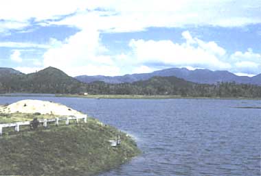
Photo: R. N. Tagaarino
A. LOCATION
- Camarines Sur, the Philippines.
- 13:05N, 123:05E.
B. DESCRIPTION
Lake Buhi is a unique tropical lake serving as home of the world's smallest commercial fish The lake provides for many uses such as fishery, navigation, water reservoir for irrigation, hydroelectric power and domestic water supply. This 1,800 hectare freshwater lake sits in the valley between two ancient volcanos, Mt. Malimas and Mt. Iriga. The lake was formed in 1641 when a strong earthquake caused the side of Mt. Iriga to collapse, forming a natural dam on small streams (Q).
C. PHYSICAL DIMENSIONS (1)
| Surface area [km2] | 15-18 |
| Maximum depth [m] | 18.2 |
| Mean depth [m] | 6.8 |
D. PHYSIOGRAPHIC FEATURES
D1 GEOGRAPHICAL (Q)
- Bathymetric map: Fig. ASI-20-01.
- Names of main islands: None.
- Number of outflowing rivers and channels (name): 1 (Tabao R.).
D2 CLIMATlC (2)
- Climatic data at Legaspi*, 1952
| Jan | Feb | Mar | Apr | May | Jun | Jul | Aug | Sep | Oct | Nov | Dec | Ann. |
| Mean temp. [deg C] | 25.7 | 25.9 | 26.7 | 27.7 | 28.2 | 28.1 | 27.4 | 27.4 | 27.3 | 27.1 | 26.7 | 26.2 | 27.0 |
| Precipitation [mm] | 366 | 265 | 218 | 158 | 178 | 194 | 235 | 209 | 252 | 313 | 479 | 503 | 3,370 |
* Circa 50 km southeast from the lake.
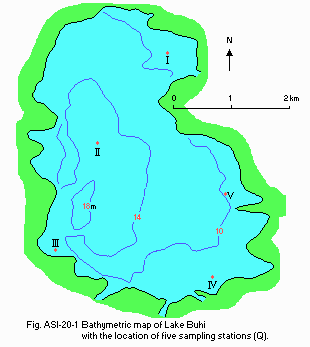
Fig. ASI-20-01
Bathymetric map with the location of five sampling stations (Q).
- Water temperature [deg C](Q)
| Iraya, October-December 1986 |
| Depth [m] | 30 Oct | 6 Nov | 17 Nov | 30 Nov | 18 Dec |
| P*1 | 28.9 | 28.6 | 28.0 | 27.8 | 27.0 |
| A*2 | 27.9 | 28.5 | 28.0 | 27.5 | 26.8 |
| Cabatuan, October-December 1986 |
| Depth [m] | 30 Oct | 6 Nov | 17 Nov | 30 Nov | 18 Dec |
| P | 28.3 | 29.3 | 28.2 | 27.8 | 27.0 |
| A | 28.2 | 29.0 | 28.0 | 27.8 | 27.0 |
| Salvacion, October-December 1986 |
| Depth [m] | 30 Oct | 6 Nov | 17 Nov | 30 Nov | 18 Dec |
| P | 29.2 | 29.9 | 28.9 | 28.1 | 28.0 |
| A | 28.3 | 29.0 | 28.0 | 28.1 | 27.2 |
| Cruz-San Buena, October-December 1986 |
| Depth [m] | 30 Oct | 6 Nov | 17 Nov | 30 Nov | 18 Dec |
| P | 28.8 | 29.3 | 28.9 | 27.5 | 27.5 |
| A | 28.2 | 29.3 | 28.0 | 27.3 | 27.5 |
| Soboc, October-December 1986 |
| Depth [m] | 30 Oct | 6 Nov | 17 Nov | 30 Nov | 18 Dec |
| P | 29.0 | 29.3 | 28.5 | 27.5 | 27.2 |
| A | 28.2 | 28.8 | 28.5 | 27.3 | 26.8 |
*1 Photic zone. *2 Aphotic zone (1 m below transparency).
E. LAKE WATER QUALITY
E1 TRANSPARENCY [m]
| Station I, October-December 1986 |
| Depth [m] | 30 Oct | 6 Nov | 17 Nov | 30 Nov | 18 Dec |
| 4.1 | 3.1 | 3.0 | 3.4 | 2.5 |
| Station II, October-December 1986 |
| Depth [m] | 30 Oct | 6 Nov | 17 Nov | 30 Nov | 18 Dec |
| 4.2 | 2.9 | 3.75 | 3.5 | 2.8 |
| Station III, October-December 1986 |
| Depth [m] | 30 Oct | 6 Nov | 17 Nov | 30 Nov | 18 Dec |
| 3.8 | 3.8 | 3.60 | 2.8 | 2.7 |
| Station IV, October-December 1986 |
| Depth [m] | 30 Oct | 6 Nov | 17 Nov | 30 Nov | 18 Dec |
| 3.3 | 2.9 | 2.8 | 3.6 | 2.6 |
| Station V, October-December 1986 |
| Depth [m] | 30 Oct | 6 Nov | 17 Nov | 30 Nov | 18 Dec |
| 3.4 | 4.4 | 4.0 | 3.2 | 2.2 |
E2 pH
| Iraya, October-December 1986 |
| Depth [m] | 30 Oct | 6 Nov | 17 Nov | 30 Nov | 18 Dec |
| P*1 | 8.15 | 8.1 | 6.9 | 8.1 | 8.5 |
| A*2 | 7.95 | 8.2 | 6.9 | 8.0 | 8.55 |
*1: Photic zone. *2: Aphotic zone (1 m below transparency).
| Cabatuan, October-December 1986 |
| Depth [m] | 30 Oct | 6 Nov | 17 Nov | 30 Nov | 18 Dec |
| P | 8.25 | 8.2 | 8.0 | 7.95 | 8.70 |
| A | 7.8 | 8.4 | 8.1 | 7.90 | 8.70 |
| Salvacion, October-December 1986 |
| Depth [m] | 30 Oct | 6 Nov | 17 Nov | 30 Nov | 18 Dec |
| P | 8.1 | 8.3 | 8.5 | 7.71 | 8.60 |
| A | 7.9 | 8.3 | 8.85 | 7.78 | 8.61 |
| Crus-San Buena, October-December 1986 |
| Depth [m] | 30 Oct | 6 Nov | 17 Nov | 30 Nov | 18 Dec |
| P | 8.3 | 8.7 | 8.7 | 7.85 | 8.5 |
| A | 8.4 | 8.7 | 8.75 | 7.90 | 8.5 |
| Soboc, October-December 1986 |
| Depth [m] | 30 Oct | 6 Nov | 17 Nov | 30 Nov | 18 Dec |
| 8.35 | 8.6 | 6.9 | 7.90 | 8.6 |
| 8.5 | 8.6 | 6.9 | 7.95 | 8.65 |
E4 DO [mg l-1]
| Station I, October-December 1986 |
| Depth [m] | 30 Oct | 6 Nov | 17 Nov | 30 Nov | 18 Dec |
| P*1 | 7.4 | 8.1 | 5.8 | 6.1 | 10.2 |
| A*2 | 7.3 | 7.2 | 6.0 | 4.5 | 10.0 |
*1 Photic zone. *2 Aphotic zone (1 m below transparency).
| Station II, October-December 1986 |
| Depth [m] | 30 Oct | 6 Nov | 17 Nov | 30 Nov | 18 Dec |
| P | 7.5 | 7.8 | 6.8 | 6.3 | 9.9 |
| A | 6.7 | 7.7 | 4.4 | 6.1 | 10.0 |
| Station III, October-December 1986 |
| Depth [m] | 30 Oct | 6 Nov | 17 Nov | 30 Nov | 18 Dec |
| P | 6.8 | 7.3 | 6.5 | 6.1 | 10.8 |
| A | 6.2 | 6.5 | 4.4 | 6.0 | 10.9 |
| Statio IV, October-December 1986 |
| Depth [m] | 30 Oct | 6 Nov | 17 Nov | 30 Nov | 18 Dec |
| P | 7.0 | 7.6 | 6.9 | 6.5 | 11.0 |
| A | 6.8 | 7.4 | 6.2 | 6.0 | 10.8 |
| Station V, October-December 1986 |
| Depth [m] | 30 Oct | 6 Nov | 17 Nov | 30 Nov | 18 Dec |
| P | 7.0 | 8.1 | 6.3 | 6.0 | 10.9 |
| A | 5.8 | 6.0 | 5.2 | 6.1 | 9.2 |
E6 CHLOROPHYLL CONCENTRATION [micro l-1]
| Station I, 1986 |
| Depth [m] | Oct | Nov | Dec |
| 0.0737 | 18.92 | 68.15 |
| Station II, 1986 |
| Depth [m] | Oct | Nov | Dec |
| 0.0338 | 33.35 | 34.8 |
| Station III, 1986 |
| Depth [m] | Oct | Nov | Dec |
| 0.2525 | 19.58 | 39.15 |
| Station IV, 1986 |
| Depth [m] | Oct | Nov | Dec |
| 0.1788 | 21.03 | 21.75 |
| Station V, 1986 |
| Depth [m] | Oct | Nov | Dec |
| 0.0748 | 6.53 | 30.45 |
E7 NITROGEN CONCENTRATION (8)
| Station I, 1986 |
| Depth [m] | 30 Oct | 6 Nov | 17 Nov | 30 Nov | 18 Dec |
| P*1 | 0.901 | 0.139 | 0.238 | 0.389 | 0.104 |
| A*2 | 0.454 | 0.104 | 0.401 | 0.421 | 0.300 |
*1 Photic zone. *2 Aphotic zone (1 m below transparency).
| Staiton II, 1986 |
| Depth [m] | 30 Oct | 6 Nov | 17 Nov | 30 Nov | 18 Dec |
| P | 0.263 | 0.295 | 0.160 | 0.170 | 0.418 |
| A | 0.617 | 0.309 | 0.125 | 0.219 | 0.575 |
| Station III, 1986 |
| Depth [m] | 30 Oct | 6 Nov | 17 Nov | 30 Nov | 18 Dec |
| P | 0.596 | 0.174 | 0.160 | 0.648 | 0.504 |
| A | 0.440 | 0.054 | 0.182 | 0.673 | 0.590 |
| Station IV, 1986 |
| Depth [m] | 30 Oct | 6 Nov | 17 Nov | 30 Nov | 18 Dec |
| P | 0.362 | 0.054 | 0.104 | 0.381 | 0.410 |
| A | 0.136 | 0.195 | 0.061 | 0.203 | 0.426 |
| Station V, 1986 |
| Depth [m] | 30 Oct | 6 Nov | 17 Nov | 30 Nov | 18 Dec |
| P | 0.341 | 0.160 | 0.132 | 0.203 | 0.394 |
| A | 0.426 | 0.182 | 0.174 | 0.227 | 0.496 |
E8 PHOSPHORUS CONCENTRATION (Q)
| Station I, 1986 |
| Depth [m] | 30 Oct | 6 Nov | 17 Nov | 30 Nov | 18 Dec |
| P*1 | 0.115 | 0.038 | 0.047 | 0.040 | 0.066 |
| A*2 | 0.095 | 0.569 | 0.059 | 0.041 | 0.038 |
*1 Photic zone. *2 Aphotic zone (1 m below transparency).
| Station II, 1986 |
| Depth [m] | 30 Oct | 6 Nov | 17 Nov | 30 Nov | 18 Dec |
| P | 0.094 | 0.077 | 0.050 | 0.088 | 0.042 |
| A | 0.095 | 0.060 | 0.047 | 0.033 | 0.035 |
| Station III, 1986 |
| Depth [m] | 30 Oct | 6 Nov | 17 Nov | 30 Nov | 18 Dec |
| P | 0.092 | 0.065 | 0.045 | 0.033 | 0.073 |
| A | 0.157 | 0.093 | 0.064 | 0.059 | 0.037 |
| Station IV, 1986 |
| Depth [m] | 30 Oct | 6 Nov | 17 Nov | 30 Nov | 18 Dec |
| P | 0.096 | 0.130 | 0.067 | 0.045 | 0.036 |
| A | 0.221 | 0.123 | 0.060 | 0.069 | 0.038 |
| Station V, 1986 |
| Depth [m] | 30 Oct | 6 Nov | 17 Nov | 30 Nov | 18 Dec |
| P | 0.143 | 0.128 | 0.057 | 0.033 | 0.040 |
| A | 0.281 | 0.120 | 0.062 | 0.034 | 0.037 |
E10 PAST TRENDS
- Watar temperature [deg C]
| 1977-1978*1 | May-Oct 1982*2 | Nov 1982-Jul 1983*2 |
| 28.5 | 27.0 | 29.0 |
*1 (3). *2 (4).
| 1977-1978*1 | 1982*2 | 1986-1987*3 |
| 0.8-4.6 | 0.4-4.0 | 2.1-4.6 |
*1 (3). *2 (4). *3 (Q).
- pH
| 1977-1978*1 | May 1982-Jul 1983*2 | 1986-1987*3 |
*1 (3). *2 (4). *3 (Q).
| 1977-1978*1 | May 1982-Jul 1983*2 |
| 8.0-11.0 | 3.45-9.95 |
*1 (3). *2 (4).
- PO4-P [mg l-1]
| 1977-1978*1 | May-Dec 1982*2 | Jun-Jul 1983*2 |
| 0.07 | 0.201 | 0.407 |
*1 (3). *2 (4).
F. BIOLOGICAL FEATURES
F1 FLORA (Q)
- Floating macrophytes: Eichhornia crassipes.
- Submerged macrophytes: Hydrilla sp., Vallisneria sp.
- Phytoplankton
Microcystis aeruginosa (perennially dominant and widely distributed).
F2 FAUNA
- Zooplankton: Protozoa, Arthropoda, Trochethninthes sp. (5).
- Benthos: Oligochaetes, Chironomus sp. (5).
- Fish: Tilapia nilotica*, mudfish, catfish (Q).
* Economically important.
F4 BIOMASS (Q)
- Total phytoplankton [g m-3]
| 1986 |
| Station | Oct | Nov | Dec |
| I | 19.3 | 8.95 | 14.0 |
| II | 15.9 | 5.65 | 11.2 |
| III | 17.8 | 7.0 | 8.2 |
| IV | 14.2 | 8.3 | 14.2 |
| V | 14.8 | 10.6 | 14.0 |
F5 FISHERY PRODUCTS
- Aunual fish catch [kg](6, 8)
1983: 55,169.
- Fishery products other than fish (Q)
Shrimps and bivalves.
F7 NOTES ON THE REMARKABLE CHANGES OF BIOTA IN THE LAKE IN RECENT YEARS
Decline in species diversity and fish yield (7, 8). Loss of migratory species
(Q).
G. SOCIO-ECONOMIC CONDITIONS
G1 LAND USE IN THE CATCHMENT AREA (7)
| 1980 |
| Area [km2] | [%] |
| Natural landscape |
| - Woody vegetation |
| Primary forest | 2,050 | 19.1 |
| Secondary forest | 2.180 | 20.3 |
| Herbaceous vegetation |
| - Active "kaingin" | 1,070 | 10.0 |
| Grassland | 710 | 6.6 |
| Agricultural land |
| - Crop field |
| Rice land | 1,807 | 16.8 |
| Coconut plantation | 2,380 | 22.1 |
| Bare areas | 555 | 5.2 |
| Total | 10,752 | 100 |
- Main types of woody vegetation
Primary and secondary forest, coconut plantation.
- Main kinds of crops
Rice, maize, sweet potato, cassava, abaca. Cropping systems: 1) relay system, 2) intercropping, 3) slash and burn farming (locally called "kaingin").
- Levels of fertilizer application on crop fields: Light.
- Trends of change in land use in recent years
Primary forest lands have diminished and being replaced by secondary forests. Annual crops such as rice and maize and perennial crops (coconut and coffee) are being planted in alienable and disposable lands. Shifting cultivation and illegal logging have become notable.
G2 INDUSTRIES IN THE CATCHMENT AREA AND THE LAKE (Q)
| No. of persons engaged | Main products or major industries |
| Primary industry |
| - Fisheries | 2,136 | Tilapia nilotica, Ophicephelus striatus, Cyprinus carpio, Palaemon sp. and bivalves |
G3 POPULATION IN THE CATCHMENT AREA (Q)
| Population | Population density [km-2] | Major cities (population) |
| Rural | 48,265 | 441 | None |
H. LAKE UTILIZATION
H1 LAKE UTILIZATION (Q)
Source of water and navigation.
I. DETERIORATION OF LAKE ENVIRONMENTS AND HAZARDS (Q)
I1 ENHANCED SILTATION
- Extent of damage: Not serious.
I3 EUTROPHICATION
- Nuisance caused by eutrophication
Unusual algal bloom: Microcystis sp.
I4 ACIDIFICATION
L. DEVELOPMENT PLANS (Q)
Hydraulic control structure in operation since 1984.
M. LEGISLATIVE AND INSTITUTIONAL MEASURES FOR UPGRADING LAKE ENVIRONMENTS
M3 RESEARCH INSTITUTES ENGAGED IN THE LAKE ENVIRONMENT STUDIES (Q)
- Program on Environmental Science and Management (PESAM)
- University of the Philippines at Los Baffos (UPLB)
N. SOURCES OF DATA
- Questionnaire filled by Dr. Marlito Lanzona Cardinas, Institute of Chemistry, University of the Philippines at Los Baiios and by Dr. Rogelto N. Tagarino, Institute of Environmental Science and Management, University of the Philippines at Los Bailos.
- PCARRD (1981) State of the Art. Lakes and Reservoirs Research, Fisheries Series No. 1. PCARRD, Los Bailos, Laguna, the Philippines.
- Flores, J. F. & Balagot, V. F. (1969) Climate of the Philippines. "World Survey of Climatology Volume 8, Climates of Northern and Eastern Asia" (ed. Arakawa, H.), pp. 177-181, Elsevier Scientific Publishing Company. Amsterdam- London-New York.
- BRBDP (1982) Annual Report. Bicol River Basin Development Program, Buhi Camarines Sur.
- Zafaralla, M. T., Cadiz, N. M., Magcale, D. B., Vidal, L. R. & Auila, L. (1986) Studies on the Phytoplankton of Lakes in Camarines Sur, the Philippines. I. Dynamics of Water Quality in Buhi in Relation to Changes in Community Structure and Primary Production. Occasional Paper No. 5. PESAM, UPLB, College, Laguna, the Philippines.
- Olatio, V. L. & Clemente, E. P. (1983) Annual Report of the Resource Assessment of Lake Buhi for 1983. Bureau of Fisheries and Aquatic Resources, Region V, Bicol Region, Philippines.
- Conway, G. R. & Sajise, P. E. (ed.)(1984) The Agroecosystems of Buhi: Problems and Opportunities, Program of Environmental Science and Management (PESAM) and BRBDP.
- Tagarino, R. N. et al. (1985) An Economic Analysis of Capture Fishery Activities in Lake Bato and Lake Buhi. Terminal Report, UPLB-PCARRD Proj. #89-320-9. UPLB, College, Laguna, the Philippines.
- Fisheries Statistics (1980) Bureau of Fisheries and Aquatic Resources (BFAR), Quezon City, the Philippines.

