
LAKE LADOGA
A view on the lakeshore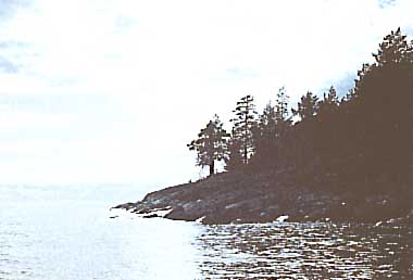 Photo: I. M. Raspopov
A. LOCATION
- Karelia, Russia.*
- 59:54-61:47N, 29:47-32:58E; 4.8 m above sea level.
* Place names are not updated.
B. DESCRIPTION
-
Lake Ladoga
is the largest freshwater body in Europe with a surface area of 18,135
km2 including the islands area of 460 km2. The volume of the lake is 908
km3, its average and maximum depths being 51 and 230 m, respectively. The
shallowest southern part has a mean depth of 13 m (the lake is divided
into four zones taking depth distribution into account).
Lake Ladoga is situated on the borderline between the crystalline Baltic shield and Great Russian Plain, and the geological history of its drainage basin (250,600 km2) is very complicated (1). Differences in the geological structure of the watershed are reflected in the structure of both shores and depressions of the lake. Seven types of bottom sediments were distinguished (2); blocks, boulders, pebbles and gravel, sand of various grain size, coarse- grained aleurite silt, fine-grained aleurite silt, and clayey silt. Clayey silt accumulates in the deepest areas of the lake. The other types of bottom sediments are characteristic of littoral and declinate zones.
The principal components of water balance are inflow and outflow, accounting for 86 and 92% of the total inputs and outputs, respectively. Since 1981 the annual inflow has varied between 77.8 and 89.0 km3 (3). Lake thermic regime is characterized by the existence of thermal bar in periods of spring warming and autumn cooling. Thermal bar divides the lake into two regions - thermoactive and thermoinert, whose water masses differ one from another by physicochemical characteristics (4). Lake Ladoga is influenced by wind waves. The maximal measured wave height amounts to 5.8 m and the maximal length to 60 m (3).
Ladoga water is poorly mineralized - average value of mineralization is 62 mg l-1. Once favorable oxygen regime is now getting worse under the influence of anthropogenic eutrophication during the last 10 years. Great attention is being paid to the preservation of water quality in Lake Ladoga. In 1984 the Council of Ministers of USSR adopted a resolution on protecting measures for Lake Ladoga and its basin. Implementing this resolution, a large pulp and paper plant in Priozersk was closed. The governmental program "Ladoga" has been elaborated and is being carried out by cooperation of several different institutions (Q).
C. PHYSICAL DIMENSIONS (3)
| Surface area [km2] | 18,135 |
| Volume [km3] | 908 |
| Maximum depth [m] | 230 |
| Mean depth [m] | 51 |
| Water level | Unregulated |
| Normal range of annual water level fluctuation [m] | 0.7 |
| Length of shoreline [km] | 1,570* |
| Residence time [yr] | 12.3 |
| Catchment area [km2] | 70,120 |
| * Not including the catchments of upstream lakes (cf. Fig. EUR-37-02). | |
D. PHYSIOGRAPHIC FEATURES
D1 GEOGRAPHICAL- Sketch map: Fig. EUR-37-02.
- Bathymetric map: Fig. EUR-37-01.
- Names of main islands
- Number of outflowing rivers and channels (name): 1 (Neva R.).
- Others
Riekkalansaari (55.3 km2), Mantsinsaari (39.4 km2) and Valaam (27.8 km2).
Physiographic zoning map: Fig. EUR-37-03.
- Climatic data at Sucho Island, 1881-1960
| Mean temp. [deg C] | ||||||||||||
| Jan | Feb | Mar | Apr | May | Jun | Jul | Aug | Sep | Oct | Nov | Dec | Ann. |
|---|---|---|---|---|---|---|---|---|---|---|---|---|
| -7.8 | -8.8 | -5.9 | -0.3 | 5.5 | 11.8 | 16.3 | 15.6 | 11.1 | 5.2 | 0.1 | -4.7 | 3.2 |
| Precipitation [mm] | ||||||||||||
| 26 | 24 | 24 | 29 | 43 | 46 | 54 | 55 | 58 | 49 | 39 | 28 | 475 |
- Number of hours of bright sunshine: 1,784 hr yr-1.
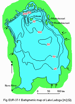
Bathymetric map [m](Q).
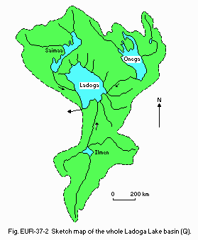
Sketch map of the whole Ladoga Lake basin (Q).
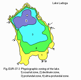
Physiographic zoning of the lake.
- Solar radiation: 9.2 MJ m-2 day-1.
- Water temperature [deg C]
| Northern part of the lake, 1959-1988 | ||||||||||||
| Depth [m] | Jan | Feb | Mar | Apr | May | Jun | Jul | Aug | Sep | Oct | Nov | Dec |
|---|---|---|---|---|---|---|---|---|---|---|---|---|
| 0.1 | 0.8 | 0.0 | - | - | 0.4 | 7.6 | 13.4 | 15.7 | 11.9 | 7.8 | 4.0 | 1.8 |
- Freezing period: February-May.
- Mixing type: Dimictic.
E. LAKE WATER QUALITY (Q)
E1 TRANSPARENCY [m]| Station 1, 1990 | ||||||||||||
| Depth [m] | Jan | Feb | Mar | Apr | May | Jun | Jul | Aug | Sep | Oct | Nov | Dec |
|---|---|---|---|---|---|---|---|---|---|---|---|---|
| 1 | - | - | - | - | 3.6 | - | 3.4 | - | - | 4.4 | - | - |
| Station 2, 1990 | ||||||||||||
| - | - | - | - | 4.0 | - | 3.3 | - | - | 3.7 | - | - | |
| Station 3, 1990 | ||||||||||||
| - | - | - | - | 3.5 | - | 3.1 | - | - | - | - | - | |
| Station 4, 1990 | ||||||||||||
| - | - | - | - | 3.5 | - | 3.5 | - | - | - | - | - | |
| Station 5, 1990 | ||||||||||||
| - | - | - | - | 5.0 | - | 3.3 | - | - | 3.3 | - | - | |
| Station 6, 1990 | ||||||||||||
| - | - | - | - | 1.8 | - | 3.1 | - | - | 3.1 | - | - | |
| Station 7, 1990 | ||||||||||||
| - | - | - | - | 3.7 | - | 3.0 | - | - | 3.3 | - | - | |
| Station 8, 1990 | ||||||||||||
| - | - | - | - | 3.6 | - | 2.5 | - | - | 3.2 | - | - | |
| Station 9, 1990 | ||||||||||||
| - | - | - | - | 1.5 | - | 2.7 | - | - | 2.7 | - | - | |
| Station 10, 1990 | ||||||||||||
| - | - | - | - | 2.8 | - | 2.7 | - | - | 1.9 | - | - | |
| Station 11, 1990 | ||||||||||||
| - | - | - | - | 1.8 | - | 2.4 | - | - | - | - | - | |
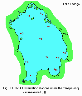
Observation stations where the transparency was measured (Q).
E2 pH
| 1981-1982 | |||
| Depth [m] | Spring | Summer | Autumn |
|---|---|---|---|
| S*1 | 7.40-8.90 | 7.25-9.50 | 7.25-7.65 |
| B*2 | 7.30-8.75 | 7.10-8.45 | 7.25-7.60 |
| *1 Surface. *2 Bottom. | |||
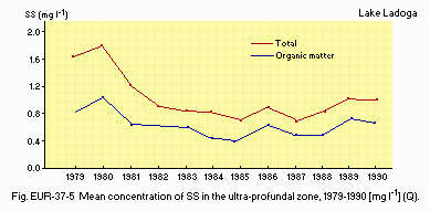
Mean concentration of SS in the ultra-profundal zone, 1979-1990 [mg l-1](Q).
E4 DO [mg l-1/%]
| Ultra-profundal zone, 1987-1988 | |||||
| 1987 | 1988 | ||||
|---|---|---|---|---|---|
| Depth [m] | Jun | Jul | Jun | Jul | Aug |
| 0 | 12.8/96 | 11.0/105 | 11.8/89 | 10.6/105 | 10.0/105 |
| 10 | 12.8/95 | 11.3/102 | 12.8/96 | 11.62/117 | 9.41/98 |
| 25 | 12.8/95 | 11.8/95 | 12.8/97 | 11.87/94 | 12.47/100 |
| 50 | - | 12.0/95 | 12.7/95 | 11.28/97 | 12.1/95 |
| 100 | 12.2/91 | 12.0/95 | 12.8/96 | 12.31/97 | 12.6/98 |
| 120 | 11.8/89 | 12.0/94 | 11.9/89 | 11.9/93 | 11.9/93 |
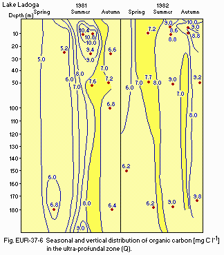
Seasonal and vertical distribution of organic carbon [mg C l-1] in the ultra- profundal zone (Q).
E6 CHLOROPHYLL CONCENTRATION: Fig. EUR-37-07 and 08.
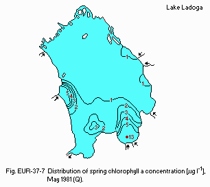
Distribution of spring chlorophyll a concentration [micro g l-1], May 1981 (Q).
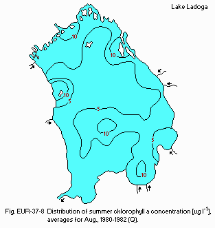
Distribution of summer chlorophyll a concentration [micro g l-1], averages for August 1980-1982 (Q).
E7 NITROGEN CONCENTRATION
- Total-N [mg l-1]
May-June*1 1986: 0.61 (0.45-0.90). July-August*2 1986: 0.60 (0.39-0.90). September-October*3 1986: 0.55 (0.42-0.91). *1 Spring. *2 Summer. *3 Autumn.
- Total-P [micro g l-1]
| Lake zone | Coastal | Declinate | Profundal | Ultraprofundal | Whole lake |
|---|---|---|---|---|---|
| 1988 | |||||
| Spring | 24 (14-59) | 25 (16-27) | 19 (15-21) | 19 (17-20) | 20 (14-59) |
| Summer | 25 (16-70) | 20 (12-36) | 19 (12-28) | 19 (14-30) | 19 (12-70) |
| Autumn | - | - | - | - | |
| 1989 | |||||
| Spring | 26 (16-40) | 24 (18-40) | 23 (18-32) | 21 (20-24) | 22 (16-40) |
| Summer | 22 (15-26) | 20 (14-27) | 19 (15-30) | 18 (13-24) | 19 (13-30) |
| Autumn | 18 (16-18) | 18 (16-26) | 18 (15-22) | 18 (15-20) | 18 (15-26) |
- DO
| Profundal zone [mg l-1 (% saturation)] | |||||||
| Depth | May | Jun | Jul | Aug | Sep | Oct | |
|---|---|---|---|---|---|---|---|
| 10 m | 1982 | - | 12.9 (97) | 10.7 (84) | 10.9 (92) | 8.8 (81) | - |
| 1983 | 8.9 (68) | - | 11.9 (105) | - | - | - | |
| 1984 | 11.9 (89) | - | 10.5 (84) | - | - | 11.0 (98) | |
| 1985 | 11.6 (109) | - | 11.8 (97) | 11.6 (97) | - | - | |
| 1986 | 12.6 (94) | - | - | 11.0 (101) | - | - | |
| 1987 | - | 12.8 (95) | 11.3 (102) | - | - | - | |
| 1988 | 12.8 (96) | 11.6 (117) | - | 9.4 (98) | - | - | |
| 50 m | 1981 | - | - | - | 12.9 (99) | - | 10.9 (96) |
| 1982 | - | 12.2 (95) | 8.9 (70) | 11.6 (92) | 10.2 (81) | - | |
| 1983 | 9.5 (72) | - | 13.0 (102) | - | - | - | |
| 1984 | 13.1 (99) | - | - | - | - | - | |
| 1985 | 12.3 (97) | - | 12.3 (97) | 12.5 (99) | - | - | |
| 1986 | 12.3 (91) | - | - | 12.0 (94) | - | - | |
| 1987 | - | - | 12.0 (95) | - | - | - | |
| 1988 | - | 12.8 (96) | 12.3 (97) | 12.6 (98) | - | - | |
| 120 m | 1981 | 12.7 (94) | - | - | 12.4 (97) | - | 12.1 (95) |
| 1982 | - | 12.2 (92) | 10.8 (85) | 10.6 (83) | 10.9 (86) | - | |
| 1983 | 8.0 (61) | - | 13.0 (102) | - | - | - | |
| 1984 | 13.2 (99) | - | 12.6 (99) | 12.5 (98) | - | 12.5 (99) | |
| 1985 | 12.6 (99) | - | 12.4 (97) | 12.5 (98) | - | - | |
| 1986 | 11.8 (89) | - | - | 11.9 (94) | - | - | |
| 1987 | - | 11.8 (89) | 12.0 (94) | - | - | - | |
| 1988 | - | 11.9 (89) | 11.9 (93) | 11.9 (93) | - | - | |
- Chlorophyll a
Mean-suspended (MS) and maximum (Max) concentrations of chlorophyll a in surface water in different seasons [micro g l-1]
| Year | Spring (May-Jun) | Summer (Jul-Aug) | Autumn (Sep-Oct) | |||
|---|---|---|---|---|---|---|
| MS | Max | MS | Max | MS | Max | |
| 1976 | 2.5 | 7.8 | 2.1 | 6.4 | - | - |
| 1977 | 1.6 | 7.0 | 2.3 | 8.2 | 0.7 | 1.5 |
| 1978 | 2.9 | 5.9 | 3.7 | 38.9 | 5.0 | 5.3 |
| 1979 | 1.6 | 1.8 | 3.3 | 25.0 | 0.4 | 1.3 |
| 1980 | 2.8 | 10.0 | 1.8 | 7.0 | 1.9 | 5.3 |
| 1981 | 2.5 | 12.6 | 3.6 | 47.0 | 1.2 | 6.0 |
| 1982 | 2.4 | 15.0 | 2.4 | 21.5 | 0.8 | 6.5 |
| 1983 | 1.8 | 8.5 | 2.5 | 35.6 | 0.7 | 1.8 |
| 1984 | 1.7 | 5.3 | 0.7 | 3.2 | 0.4 | 1.2 |
| 1985 | - | - | 2.0 | 14.5 | 0.4 | 1.3 |
| 1986 | 2.9 | 13.5 | 2.1 | 7.0 | 0.6 | 1.7 |
| 1987 | 4.2 | 17.2 | 1.7 | 4.2 | - | - |
| 1988 | 1.7 | 5.1 | 1.3 | 14.3 | 1.6 | 4.1 |
| 1989 | 2.1 | 6.3 | 2.9 | 6.4 | 3.0 | 13.0 (66.5) |
- Nitrogen concentration [mg l-1]
| Spring (May-Jun) | Summer (Jul-Aug) | Autumn (Sep-Oct) | |
|---|---|---|---|
| 1981 | 0.73 (0.60-1.20) | 0.74 (0.50-1.42) | 0.66 (0.50-0.97) |
| 1982 | 0.59 (0.45-0.95) | 0.59 (0.43-0.99) | 0.55 (0.50-0.87) |
| 1983 | 0.83 (0.71-1.44) | 0.69 10.61-1.26) | - |
| 1984 | 0.77 (0.52-1.12) | 0.53 (0.42-0.86) | 0.66 (10.55-1.12) |
| 1986 | 0.61 (0.45-0.90) | 0.60 (0.39-0.90) | 0.55 (0.42-0.91) |
- Phosphorus concentration
Total-P [micro g l-1]
| Zone | Spring | Summer | Autumn | |
|---|---|---|---|---|
| Coastal | 1981 | 42 | 37 | 49 |
| 1982 | 35 | 37 | 44 | |
| 1983 | 30 | 36 | 23 | |
| 1984 | 33 | 35 | 38 | |
| 1986 | 30 | 40 | 34 | |
| 1987 | 39 | 50 | - | |
| 1988 | 24 | 25 | - | |
| 1989 | 26 | 22 | 18 | |
| Ultra-profundal | 1981 | 21 | 29 | 21 |
| 1982 | 23 | 20 | 19 | |
| 1983 | 24 | 20 | - | |
| 1984 | 24 | 24 | 24 | |
| 1986 | 17 | 22 | 26 | |
| 1987 | 21 | 22 | - | |
| 1988 | 19 | 19 | - | |
| Whole lake | 1981 | 24 | 28 | 21 |
| 1982 | 24 | 23 | 22 | |
| 1983 | 24 | 24 | 21 | |
| 1984 | 24 | 24 | 23 | |
| 1986 | 18 | 24 | 27 | |
| 1987 | 21 | 24 | - | |
| 1988 | 20 | 19 | - | |
| 1989 | 22 | 19 | 18 |
F. BIOLOGICAL FEATURES
F1 FLORA (7, 9)- Emerged macrophytes
- Floating macrophytes
- Submerged macrophytes
- Phytoplankton
- Phytoperiphyton
Phragmites australis, Scolochloa festucacea, Glyceria maxima, Scirpus lacustris, Eleocharis palustris, Equisetum fluviatile.
Nuphar lutea, Polygonum amphibium, Potamogeton natans, Hydrocharis morsus- ranae, Stratiotes aloides, Sparganium emersum.
Potamogeton perfoliatus, P. gramineus, Elodea canadensis, Myriophyllum spicatum.
Spring (Aulacosira islandica, Asterionella formosa, Diatoma elongatum), summer (A. formosa, Fragilaria crotonensis, Tribonema affine, Oscillatoria tenuis, O. planctonica, Aphanizomenon flos-aque), autumn (Woronichinia naegeliana, Aulacosira islandica, Tribonema depauperatum, Aphanizomenon flos-aque).
Spring (Tabellaria fenestrata, Fragilaria crotonensis), summer (Oedogonium sp., Cladophora glomerata, Ulothrix zonata).
- Zooplankton
- Benthos
- Fish
- Supplementary notes on the biota
Spring (Cyclops abyssorum, Limnocalanus macrurus, Eudiaptomus gracilis, Keratella quadrata, Kellicotia longispina), summer (Asplanchna priodonta, Limnocalanus macrurus, Cyclops abyssorum, Mesocyclops olthonoides, Bosmina obtusirostris, Daphnia cristata).
Pontoporeia affinis, Lamprodrilus isoporus, Peloscolex ferox, Procladius, Cryptochironomus, Isochaetides newaensis, Trissocladius parataricus, Prodiamesa bathyphila, Polypedilum, Stylodrilus heringianus, Potamothrix hammoniensis, Pallasea quadrispinosa.
46 species: Coregonus lavaretus, C. abula, Osmerus eperlanus, Stizostedion luciperca, Perca fluviatilis, Lota lota, Salmo salar.
Relict species: Pontoporeia affinis, Pallasea quadrispinosa, Mysis oculata var. relicta, Mesidothea entomon.
| Season | Lake zone | Whole lake mean | |||
|---|---|---|---|---|---|
| Coastal | Declinate | Profundal | Ultra-profundal | ||
| Spring | 160 | 732 | 537 | 164 | 454 |
| Summer | 1,026 | 805 | 943 | 1,605 | 1,031 |
| Autumn | 623 | 119 | 252 | 168 | 275 |
| Production rates of basic seasonal complexes of phytoplankton | ||
| Complex | Chlorophyll a content [micro g l-1] | Daily production [micro g l-1] |
|---|---|---|
| - Spring | ||
| Aulacosira (thermoactive area) | 2.7 (0.4-7.2) | 324 (19-1,183) |
| Aulacosira (thermoinert area) | 0.2 (0.02-2.6) | 13 (3-36) |
| Aulacosira-Asterionella (thermoactive area) | 1.7 (0.9-3.5) | 171 (65-315) |
| Aulacosira-Diatoma (thermoinert area) | 2.1 (1.9-4.9) | 391 (109-1,050) |
| - Summer | ||
| Asterionella | 1.4 (0.5-11.7) | 45 (13-210) |
| Asterionella-Diatoma | 3.5 (1.7-8.2) | 273 (68-492) |
| Asterionella-Tribonema | 2.4 (2.3-2.5) | 123 (74-452) |
| Tribonema | 1.6 (0.6-3.3) | 180 (49-173) |
| Tribonema-Peridinea | 1.4 (0.2-3.5) | 109 (42-294) |
| Fragilaria | 1.4 (0.9-1.5) | 127 (78-177) |
| Oscillatoria | 1.6 (0.2-2.4) | 270 (120-387) |
| Aphanizomenon | 2.3 (0.2-21.3) | 117 (14-1,390) |
| Microcystis | 3.0 (0.2-6.3) | 237 (7-4,220) |
| - Autumn | ||
| Woronichinia | 0.6 (0.2-1.0) | 69 (42-96) |
| Aulacosira-Tribonema | 1.1 (0.3-1.6) | 27 (2-97) |
- Macrophytes
- Phytoperiphyton
- Zoobenthos
Mean per water surface: 3.1 [g (dry wt.) m-2]. Phragmites: 929 (529-1,820)[g m-2]. Scirpus: 280-660 [g m-2]. Potamogeton perfoliatus: 105-340 [g m-2].
Ulothrix zonata: 200-400*1 [mg cm-2]. Diatoms: ca. 1*2 [mg cm-2]. Periphyton: ca. 2.0*3 [mg cm-2]. *1 On substrata at 0.0-0.5 m depth. *2 At depths more than 0.5 m in the northern part of the lake. *3 In the southern part of the lake.
Mean: 2.5 [g (wet wt.) m-2].
- Annual fish catch [metric tons]
1986: 5,527*. * Total 8,000 including angling.
- Phytoplankton production [micro C m-2]
| Season | Year | Lake Zone | Whole lake mean | |||
|---|---|---|---|---|---|---|
| Coastal | Declinate | Profundal | Ultraprofundal | |||
| Spring | 1976 | 87 | 46 | 22 | 5 | 40 |
| 1977 | 351 | 568 | 205 | 53 | 276 | |
| 1978 | 615 | 1,090 | 388 | 100 | 511 | |
| 1981 | 526 | 711 | 85 | 16 | 232 | |
| 1982 | 262 | 728 | 51 | 34 | 210 | |
| 1983 | 1,515 | 784 | 152 | 121 | 696 | |
| 1984 | 198 | 135 | 52 | 23 | 102 | |
| 1985 | 319 | 240 | 172 | 32 | 199 | |
| 1986 | 439 | 345 | 291 | 40 | 296 | |
| 1987 | 273 | 559 | 24 | 4 | 232 | |
| 1988 | 480 | 585 | 131 | 60 | 327 | |
| 1989 | 160 | 732 | 537 | 164 | 454 | |
| Summer | 1976 | 71 | 470 | 111 | 230 | 147 |
| 1977 | 391 | 479 | 375 | 554 | 435 | |
| 1978 | 640 | 1,852 | 1,527 | 224 | 946 | |
| 1981 | 387 | 902 | 414 | 475 | 434 | |
| 1982 | 310 | 497 | 391 | 576 | 360 | |
| 1983 | 346 | 144 | 67 | 135 | 158 | |
| 1984 | 158 | 227 | 200 | 329 | 221 | |
| 1985 | 2,442 | 1,809 | 2,480 | 3,726 | 2,482 | |
| 1986 | 554 | 1,328 | 1,029 | 1,575 | 1,111 | |
| 1987 | 248 | 250 | 375 | 252 | 291 | |
| 1988 | 751 | 332 | 465 | 251 | 449 | |
| 1989 | 1,026 | 805 | 943 | 1,605 | 1,031 | |
| Autumn | 1977 | 55 | 20 | 72 | 7 | 52 |
| 1981 | 235 | 115 | 85 | 117 | 135 | |
| 1982 | 142 | 89 | 199 | 240 | 174 | |
| 1983 | 14 | 44 | 40 | 40 | 34 | |
| 1984 | 124 | 10 | 9 | 12 | 34 | |
| 1985 | 254 | 216 | 125 | 84 | 172 | |
| 1986 | 90 | 75 | 82 | 48 | 76 | |
| 1987 | 114 | 68 | 84 | 62 | 82 | |
| 1988 | 480 | 220 | 432 | 47 | 314 | |
| 1989 | 623 | 119 | 252 | 168 | 275 | |
- Trend of the average number of bacterioplankton in summer [1.0E+6 cells ml-1]
| Total No. of bacterioplankton | |||
|---|---|---|---|
| Year | Lake zone | Epilimnion | Hypolimnion |
| 1980 | Coastal | 0.84 | - |
| Declinate | 0.70 | 0.41 | |
| Profundal | 0.61 | 0.14 | |
| Ultra-profundal | 0.42 | 0.12 | |
| Whole lake | 0.67 | 0.24 | |
| 1981 | Coastal | 0.80 | - |
| Declinate | 1.00 | 0.39 | |
| Profundal | 1.00 | 0.29 | |
| Ultra-profundal | 1.20 | 0.23 | |
| Whole lake | 1.00 | 0.30 | |
| 1982 | Coastal | 1.00 | - |
| Declinate | 0.85 | 0.49 | |
| Profundal | 0.91 | 0.36 | |
| Ultra-profundal | 0.85 | 0.34 | |
| Whole lake | 0.90 | 0.40 | |
| 1983 | Coastal | 0.84 | - |
| Declinate | 0.75 | - | |
| Profundal | 0.70 | - | |
| Ultra-profundal | 0.40 | - | |
| Whole lake | 0.72 | - | |
| 1984 | Coastal | 0.50 | - |
| Declinate | 0.70 | 0.51 | |
| Profundal | 0.90 | 0.43 | |
| Ultra-profundal | 0.70 | 0.47 | |
| Whole lake | 0.72 | 0.47 | |
| 1985 | Coastal | 0.70 | - |
| Declinate | 0.90 | 0.63 | |
| Profundal | 0.90 | 0.41 | |
| Ultra-profundal | 0.90 | 0.54 | |
| Whole lake | 0.86 | 0.52 |
- Fishery production [t yr-1]
| Year | Catch |
|---|---|
| 1981 | 6,915 |
| 1982 | 6,770 |
| 1983 | 5,540 |
| 1984 | 6,461 |
| 1985 | 5,091 |
| 1986 | 5,527 |
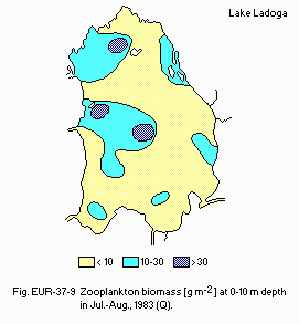
Zooplankton biomass [g m-2] at 0-10 m depth in Jul.-Aug., 1983 (Q).
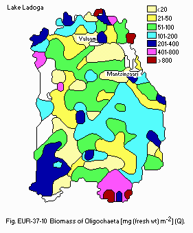
Biomass of Oligochaeta [mg (fresh wt) m-2](Q).
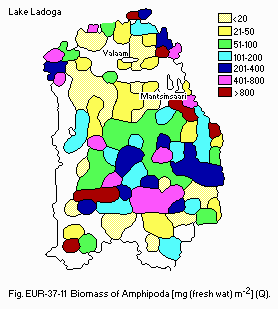
Biomass of Amphipoda [mg (fresh wt) m-2](Q).
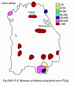
Biomass of Mollusca [mg (fresh wt) m-2](Q).
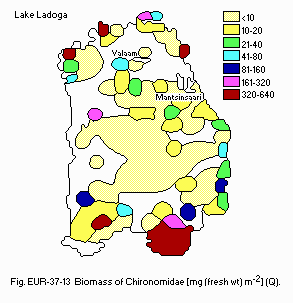
Biomass of Chironomidae [mg (fresh wt) m-2](Q).
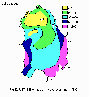
Biomass of meiobenthos [mg m-2](Q).
G. SOCIO-ECONOMIC CONDITIONS (Q)
G1 LAND USE IN THE CATCHMENT AREA| 1987 | ||
| Area [km2] | [%] | |
|---|---|---|
| - Natural landscape | ||
| Woody vegetation | 51,180 | 73.0 |
| Swamp | 7,250 | 10.3 |
| Others | 2,460 | 3.5 |
| - Agricultural land | ||
| Crop field | 2,140 | 3.1 |
| Pasture land | 960 | 1.4 |
| - Residential area | 1,420 | 2.0 |
| - Others | 4,710 | 6.7 |
| - Total | 70,120 | 100.0 |
- Types of important forest vegetation: Pine and fir.
- Types of the other important vegetation: Peat-bogs.
- Main kinds of crops and/or cropping system: Vegetable-growing.
- Levels of fertilizer application on crop fields: Moderate.
| 1987 | |||
| Population | Population density [km-2] | Major cities (population) | |
|---|---|---|---|
| Urban | 688,000 | 9.8 | Nowgorod, Tikhvin, |
| Rural | 216,000 | 3.1 | Kirishi, Volkhov, Pikalevo, Lodeynoye Pole |
| Total | 904,000 | 12.9 | |
H. LAKE UTILIZATION (Q)
H1 LAKE UTILIZATION 1990- Source of water, navigation and transportation, sightseeing and tourism,
recreation (swimming, sport-fishing, yachting) and fisheries.
| Use rate [m3 sec-1] | |
|---|---|
| - Domestic | 26.3 |
| - Irrigation | |
| Agricultural | 1.5 |
| - Industrial | 28.2 |
| - Power plant | - |
| - Others | 1.4 |
| - Total | 57.4 |
| * With calculation by Leningrad water-supply. | |
I. DETERIORATION OF LAKE ENVIRONMENTS AND HAZARDS (Q, 1, 2, 8, 9, 16)
I1 ENHANCED SILTATION- Extent of damage: Not serious.
- Present status: Detected but not serious.
- Metal concentration
| Mean/range [g l-1], 1982-1986 | |||||
| Ion/Lake zone | Coastal | Declinate | Profundal | Ultraprofundal | Whole lake |
|---|---|---|---|---|---|
| Fe | 225 | 160 | 118 | 91 | 148 |
| 45-1,150 | 45-1,730 | 33-890 | 15-250 | 15-1,730 | |
| Al | 88 | 63 | 51 | 40 | 60 |
| 12-420 | 19-240 | 12-210 | 10-150 | 10-420 | |
| Mn | 17.0 | 9.0 | 5.2 | 2.2 | 8.4 |
| 1.8-100 | 1.2-135.0 | 1.0-80.0 | 0.5-7.0 | 0.5-135.0 | |
| Cu | 6.7 | 6.7 | 5.8 | 5.7 | 6.0 |
| 1.0-22.0 | 1.0-24.5 | 1.4-15.5 | 0.5-18.9 | 0.5-24.5 | |
| Pb | 1.5 | 1.6 | 1.5 | 1.6 | 1.6 |
| 0.5-4.0 | 0.5-5.5 | 0.5-6.0 | 0.5-4.5 | 0.5-6.0 | |
- Nuisance caused by eutrophication
Unusual algal bloom (Aulacosira islandica, Diatoma elongatum, Microcystis aeruginosa, Aphanizomenon flos-aque, Woronichinia naegeliana, Tribonema affine), disturbed filtration in cleaning beds.
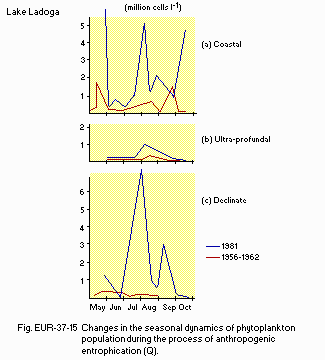
(Q) Changes in the seasonal dynamics of phytoplankton population during the process of anthropogenic eutrophication.
- Nitrogen and phosphorus loadings to the lake [t yr-1]
| 1987 | |||||||
| Sources | Industrial | Domestic | Agricultural | Aerial | Natural | Total | |
|---|---|---|---|---|---|---|---|
| T-N | - | - | - | - | - | 81,200 | |
| T-P | 2,500 | 700 | 1,400 | 400 | 1,200 | 6,200 | |
- Extent of damage
Detected but not serious (due to atmospheric transport).
J. WASTEWATER TREATMENTS (Q)
J1 GENERATION OF POLLUTANTS IN THE CATCHMENT AREA- d) Measurable pollution with limited wastewater treatment.
| T-P [%] | |
|---|---|
| - Point sources | |
| Municipal (domestic wastewater) | 11 |
| Industrial wastewater | 40 |
| - Non-point sources | |
| Agricultural runoff | 23 |
| Aerial precipitation | 6 |
| Natural sources | 20 |
| Total | 100 |
L. DEVELOPMENT PLANS (Q)
- Project "Ladoga".
M. LEGISLATIVE AND INSTITUTIONAL MEASURES FOR UPGRADING LAKE ENVIRONMENTS (Q)
M1 NATIONAL AND LOCAL LAWS CONCERNED- Names of the laws (the year of legislation)
- Principles of Water Laws for USSR and Soviet Republics, Supreme Council of the USSR (1970)
- About Measures on Protection Intensification of Baltic Sea from Pollution, Council of Ministers of USSR (1976)
- RSFSR Water Code, Supreme Council of RSFSR (1980)
- About Additional Measures on Ensuring of Protection and Rational Use of Water and Other Natural Resources in Lakes Ladoga, Onega and Ilmen, Council of Ministers of USSR (1984)
- Responsible authorities
- State Sanitary Inspection
- State Fish Inspection
- North-Western Administration of State Committee of Hydrometeorology
- USSR State Committee for Environment Protection, Leningrad Branch
- Main items of control
- Toxic substances (ions of heavy metals and others)
- Phenols, oil, pollutants of industrial, domestic and agricultural origin
- Institute of Limnology, Academy of Science of USSR, Leningrad
- State Research Institute for Fish Industry (GosNIORCH), Leningrad
N. SOURCES OF DATA
- Questionnaire filled by Dr. I. M. Raspopov, Institute of Limnology, Academy of Science of USSR, Leningrad. l) Arkhangelsky, A. D. (1947, 1948) Geological Structure and Geological History of the USSR. 415 pp. (I) and 372 pp. (II). Publ. House Ac. Sci. USSR, Moscow (In Russian).
- Semenovich, N. I. (1966) Bottom Sediments of Lake Ladoga. Publ. House Ac. Sci. USSR. 124 pp. Moscow and Leningrad (In Russian).
- Malinina, T. I. (ed.)(1966) Hydrological Regime and Balance of Lake Ladoga. 324 pp. Publ. House Ac. Sci. USSR, Leningrad (In Russian).
- Tikhomirov, A. I. (1982) Thermal Structure of Large Lakes. 232 PP. Publ. House Nauka, Leningrad (In Russian).
- Climate of USSR Reference Book (1974) Publ. House Hydrometeoizdat, Leningrad, 284 pp. (In Russian).
- Long Standing Data of Conditions and Resources of Inland Surface Waters, 1 (5)(1986) Publ. House Hydrometeoizdat, Leningrad, 688 pp. (In Russian).
- Petrova, N.A. (ed.)(1982) Anthropogenic Eutrophication of Lake Ladoga. 304 pp. Publ. House Nauka, Leningrad (In Russian).
- Petrova, N.A. & Raspletina, G. F. (eds.)(1987) Natural State of the Lake Ladoga Ecosystem. 213 pp. Publ. House Nauka, Leningrad (In Russian).
- Raspopov, I. M. (1985) Higher Auqatic Vegetation of Large Lakes in the Northwestern Area of the USSR. 200 pp. Publ. House Nauka, Leningrad (In Russian).
- Menshutkin, V. V., Slepukhina, T. D., Menshutkina, M. V. & Suvorova, T. P. (1986) Distribution of bottom invertebrates, eatable for fish in Lake Ladoga. In: Biological Characteristics of Trade Fish in Lake Ladoga and Finnish Gulf and Their Economical Use, pp. 76-89, Leningrad (In Russian).
- Fedorova, G. V. (1987) Fish catch from Lake Ladoga and causes of its fluctuations. Trudy GosNIORCH, Leningrad, 266, pp. 3-10 (In Russian).
