
LOCH LOMOND
A view on the lakeshore at Balloch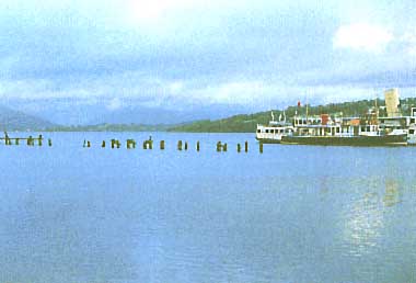 Photo: A. Kurata
A. LOCATION
- Scotland, UK.
- 56:05N, 4:35W; 7.9 m above sea level.
B. DESCRIPTION
- Of glacial origin, Loch Lomond is probably the
best known Scottish lake and is the most southerly of the five Scottish
lakes considered in this report. Its main axis is north to south and maximum
length of 36.4 km. The northern portion of the lake is long (22.3 km) and
narrow (average just over one kilometer), but south of Ross Point it opens
out and reaches a maximum width of 8.8 km. This part of lake contains many
islands. The surface area of the lake is 71.1 km2 - larger than any other
British standing water, the nearest rivals being Loch Ness (56.4 km2) and
Loch Awe (38.5 km2). The maximum depth is 189.9 m (the third deepest in
Scotland) but the mean depth is only 37.0 m, because of the influence of
the large shallow southern basin. The volume of Loch Lomond is 2,627,900,000
m3, greater than any other lakes except Loch Ness. There are two distinct
basins deeper than 30 m in the lake, one in the south of the Douglas Water
delta and one in the north and these are known to have quite distinct characteristics.
Loch Lomond's catchment is characterized by a relatively low mean altitude and gentle slopes with a high percentage of arable ground and base-rich rocks. There are far more roads than in any of the other catchments and relatively high population. The extent of arable ground and base-rich rocks gives a good indication of the potential natural richness of the lake waters draining from them. The lake, or certainly its south basin, seems likely to be the richest, comparing with the other four Scotland lakes. The lake exhibits a dimictic circulation and is rated oligotrophic in respect of chemistry, phytoplankton and macrophytes, but mesotrophic in terms of invertebrates and fish (1, 2, 4, 10).
C. PHYSICAL DIMENSIONS (1, 2, 10)
| Surface area [km2] | 71 |
| Volume [km3] | 2.6 |
| Maximum depth [m] | 189.9 |
| Mean depth [m] | 37.0 |
| Water level | Regulated |
| Normal range of annual water level fluctuation [m] | 2.0 |
| Length of shoreline [km] | 153.5 |
| Residence time [yr] | 1.9 |
| Catchment area [km2] | 696 |
D. PHYSIOGRAPHIC FEATURES
D1 GEOGRAPHICAL (2)-
Bathymetric map:
Fig. EUR-28-01.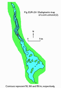
- Names of main islands: The area of island is 0.269 km2.
- Number of outflowing rivers and channels (name): 1 (R. Leven).
- Climatic data at Achnashellach (3)*
| Mean temp. [deg C] | ||||||||||||
| Jan | Feb | Mar | Apr | May | Jun | Jul | Aug | Sep | Oct | Nov | Dec | Ann. |
|---|---|---|---|---|---|---|---|---|---|---|---|---|
| 2.8 | 3.2 | 5.2 | 6.9 | 10.1 | 12.4 | 13.8 | 13.6 | 11.6 | 8.7 | 5.7 | 4.1 | 8.2 |
| Precipitation [mm] | ||||||||||||
| 232 | 177 | 127 | 156 | 93 | 114 | 148 | 150 | 189 | 234 | 196 | 242 | 2,058 |
| * 13-year mean. | ||||||||||||
- Number of hours of bright sunshine: 1,374 hr yr-1.
- Fig. EUR-28-01
Bathymetric map (2).
-
Water temperature:
Fig EUR-28-02.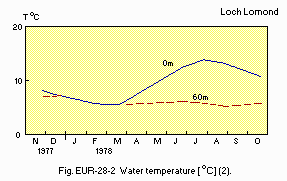
- Fig. EUR-28-02
Water temperature [deg C](2).
- Freezing period: Occasionally (2).
- Mixing type: Monomictic (2).
E. LAKE WATER QUALITY
E1 TRANSPARENCY [m](6)- November 1977 and October 1978: 4.20-6.75.
| 1977 | ||||||||||||
| Depth [m] | Jan | Feb | Mar | Apr | May | Jun | Jul | Aug | Sep | Oct | Nov | Dec |
|---|---|---|---|---|---|---|---|---|---|---|---|---|
| 0-10 | - | - | - | - | - | - | - | - | - | - | 6.2 | 6.8 |
| 1978 | ||||||||||||
| 0-10 | - | 6.8 | 6.9 | - | 6.6 | 6.7 | 6.9 | 6.7 | - | 6.7 | - | - |
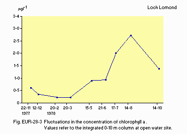
Fluctuations in the concentration of chlorophyll a. Values refer to the integrated 0-10 m column at open water site (5).
E7 NITROGEN CONCENTRATION: Fig. EUR-28-04.
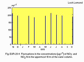
Fluctuations in the concentrations [micro g l-1] of NO3- and NO2-N in the uppermost 10 m of the water column (4).
E8 PHOSPHORUS CONCENTRATION (4)
- PO4-P [micro g l-1]
November 1977-October 1978: <10.
F. BIOLOGICAL FEATURES
F1 FLORA- Submerged macrophytes (6)
- Phytoplankton (5)
Isoetes lacustris, Littorella uniflora, Nitella opaca, Fontinalis antipyretica, Lobelia dortmanna.
Melosira islandica, M. italica subsp. subarctica, M. granulata, Asterionella formosa, Tabellaria fenestrata v. asterionelloides, T. flocculosa, Cryptomonas spp., Mallomonas spp., Rhodomonas minuta, Gymnodinium helveticum.
- Zooplankton (7)
- Benthos (8)
- Fish (9)
Bosmina coregoni, Polyhemus pediculus, Bythotrephes longimanus, Leptodora kindti, Diaptomus gracilis, Cyclops abyssorum, Diaphanosoma brachyurum, Holopedium gibberum, Daphnia hyalina, Cyclops leuckarti.
Stylaria lacustris, Ecdyonurus venosus, E. dispar, Ephemerella ignita, Diura bicaudata, Chloroperla torrentium, Tinodes waeneri, Lepidostoma hirtum.
Coregonus lavaretus, Petromyzon marinus, Lampetra fluviatilis, Salmo salar, Esox lucius, Rutilus rutilus, Noemacheilus barbatulus, Pungitius pungitius, Perca fluviatilis, Platichthys flesus.
-
Zooplankton:
Fig. EUR-28-05.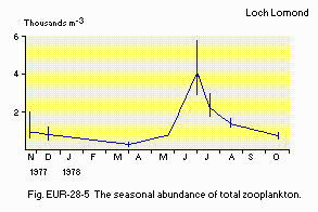
- Fig. EUR-28-05
Seasonal abundance of total zooplankton [1,000 individuals m-3].
F5 FISHERY PRODUCTS (10)
- Annual fish catch [individuals]
| 1971-1985 |
| Salmon/grilse: 318. |
| Sea trout: 1,744. |
| Brown trout: 148. |
| The mean annual numbers and the mean weights of fish caught | ||||||
| Salmon/grilse | Sea trout | Brown trout | ||||
|---|---|---|---|---|---|---|
| No. | Wt. [kg] | No. | Wt. [kg] | No. | Wt. [kg] | |
| 1956-1960 | 460 | 4.0 | 1,838 | 0.8 | 460 | 0.4 |
| 1961-1965 | 755 | 4.1 | 2,881 | 0.8 | 1,029 | 0.2 |
| 1966-1970 | 837 | 4.5 | 3,069 | 0.8 | 837 | 0.2 |
| 1971-1970 | 592 | 4.1 | 2,716 | 0.8 | 568 | 0.3 |
| 1976-1980 | 176 | 3.3 | 1,095 | 1.0 | 253 | 0.5 |
| 1981-1985 | 186 | 3.1 | 1,421 | 1.0 | 148 | 0.6 |
G. SOCIO-ECONOMIC CONDITIONS
G1 LAND USE IN THE CATCHMENT AREA (1)| 1978 | ||
| Area[km2] | [%] | |
|---|---|---|
| - Natural landscape | ||
| Woody vegetation | 76.7 | 11.0 |
| Rough | 481.5 | 69.2 |
| - Agricultural land | 116.0 | 16.7 |
| - Residential area | 10.8 | 1.6 |
| - Others | 10.5 | 1.5 |
| - Total | 695.5 | 100.0 |
| 1975 | |||
| Population | Population density [km-2] | Major cities (population) | |
|---|---|---|---|
| Total | 12,218 | 17.6 | None (18,000 tourists during summer season) |
H. LAKE UTILIZATION (10)
H1 LAKE UTILIZATION- Source of water, navigation (ferries), tourism and recreation (swimming,
sport-fishing, yachting, cruising, rowing, canoeing).
| 1988 | |
| Use rate [m3 Sec-1] | |
|---|---|
| Domestic | 2.0 |
| Industrial | 1.0 |
I. DETERIORATION OF LAKE ENVIRONMENTS AND HAZARDS (4)
I1 ENHANCED SILTATION- Extent of damage: None.
- Present status: Not detected.
- Nuisance caused by eutrophication: None.
- Extent of damage: None.
J. WASTEWATER TREATMENTS (1, 10)
J1 GENERATION OF POLLUTANTS IN THE CATCHMENT AREA- c) limited pollution with wastewater treatment.
- Municipal wastewater treatment systems
- Industrial wastewater treatment systems
No. of municipal wastewater treatment systems: 17.
No. of industrial wastewater treatment systems: 2.
L. DEVELOPMENT PLANS (10)
- A comprehensive development plan was produced in 1982 by the Loch lomond
Planning Group. This plan was adopted in August, 1986 by the four local
authorities involved and now awaits central government commitment to the
financial implications.
M. LEGISLATIVE AND INSTITUTIONAL MEASURES FOR UPGRADING LAKE ENVIRONMENTS (10)
M3 RESEARCH INSTITUTES ENGAGED IN THE LAKE ENVIRONMENT STUDIES- Clyde River Purification Board
- Central Scotland Water Development Board
- North of Scotland Hydro-Electric Board
- University of Glasgow
- University of St. Andrews
- Loch Lomond Angling Improvement Association
- Loch lomond Association
- The Friends of Loch Lomond
N. SOURCES OF DATA
- Maitland, P. S. (1981) Introduction and catchment analysis. The Ecology of Scotland's Largest lochs, Lomond, Awe, Ness, Morar and Shiel (ed. Maitland, P. S.), pp. 1-27. Dr. W. Junk Publishers, The Hague.
- Smith, I. R., Lyle, A. A. & Rosie, A. J. (1981) Comparative physical limnology. Ibid., pp. 29-65.
- Muller, M. J. (1982) Selected Climatic Data for a Global Set of Standard Stations for Vegetation Science. 306 pp. Dr. W. Junk Publishers, The Hague.
- Bailley-Watts, A. E. & Duncan, P. (1981) Chemical characterisation, a one-year comparative study. The Ecology of Scotland's Largest Lochs, lomond, Awe, Ness, Morar and Shiel (see above), pp. 67-89.
- --- (1981) The phytoplankton. Ibid., pp. 91-118.
- --- (1981) A review of macrophyte studies. Ibid., pp. 119-134.
- Maitland, P. S., Smith, B. D. & Dennis, G. M. (1981) The crustacean zooplankton. Ibid., pp. 135-154.
- Smith, B. D., Maitland, P. S., Young, M. R. & Carr, M. J. (1981) Ibid., pp. 155-203.
- Maitland, P. S., Smith, B. D. & Adair, S. M. (1981) The fish and fisheries. Ibid., pp. 223-251.
- Hamilton, J. D. (1988) Verh. Internat. Verein. Limnol., 23: 403-413.
