
LAGO LACAR (LAKE LACAR)
A view from the lakeside hill
Photo: A.Mariazzi
A. LOCATION
- Neuquen, Argentina.
- 40:11S, 71:32W; 630 m above sea level.
B. DESCRIPTION
-
Lake Lacar is located at approximately 40 degrees of south latitude and 71 degrees of west longitude in the province of Neuquen. The lake is embeded in the Andes Mountains Range and surrounded by a mountainous region, ranging 1,600 to 1,900 m. This stretched area contains in its interior the lake, which is a lacustrine hollow that occupies the lowest zone.
The basin of the lake extends towards the east up to San Martin de los Andes and Maipu. Towards the west the Nonthue lake forms its natural prolongation, being separated from the principal flow by a narrow valley. Towards the northwest it extends through the valley of Hua-Hum River, which cross the boundary with the Republic of Chile and goes into the Chilean territory.
Lake Lacar, as well as other basins which have a glacial origin, is characterized by the typical erosion of the ice in its surroundings. Its water surface is placed at 630 m above sea level.
Several rivers and streams come from the mountainous zone which is adjacent to the drawdown occupied by the lake and they come out through the Hua-Hum River. It has been estimated that the hydrographic basin of this drawdown has an area of 1,048 km2. No flux measurements are made in this river as it turns impossible to reach it by land. The only information available is the estimation made by Engineer Figueroa Bunge (CFI, 1961) who said that it had a mean flux of 50 m3 sec-1 at the boundary between Argentina and Chile.
The drainage basin of the lake is almost uninhabited, with the only exception of the northeast coast where San Martin de los Andes city is located. This city has about 12,000 inhabitants and its economy is based on tourism. The main activities are sport and recreational, the most important of them are hunting, fishing, sailing, ski and other aquatic sports.
C. PHYSICAL DIMENSIONS
| Surface area [km2] | 55 |
| Volume [km3] | 9.2 |
| Maximum depth [m] | 277 |
| Mean depth [m] | 167 |
| Length of shoreline [km] | 69.5 |
| Residence time [yr] | 5.8 |
| Catchment area [km2] | 1,048 |
D. PHYSIOGRAPHIC FEATURES
D1 GEOGRAPHICAL- Sketch map: Fig. SAM-07-0l.
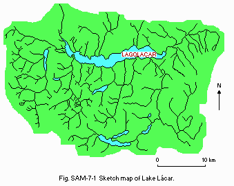
Sketch map.
D2 CLIMATIC
- Climatic data at Hotel Lacar station: Fig. SAM-07-02 and 03.
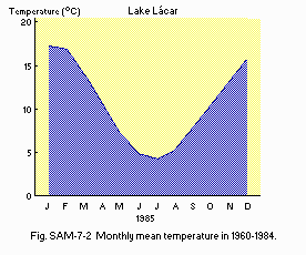
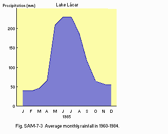
Average monthly rainfall in 1960-1984.
- Number of hours of bright sunshine (San Carlos de Bariloche, 1951-1960):
2,587 hr yr-1.
- Water temperature: Fig. SAM-07-04.
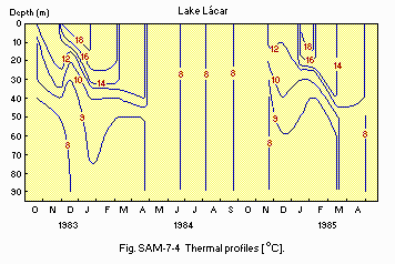
Thermal profiles [deg C].
E. LAKE WATER QUALITY
E1 TRANSPARENCY [m]| Mean value of several stations, 1984 | |||||||||||
| Jan | Feb | Mar | Apr | May | Jun | Jul | Aug | Sep | Oct | Nov | Dec |
|---|---|---|---|---|---|---|---|---|---|---|---|
| 12.9 | - | - | 14.7 | 16 | 17.8 | - | 16.6 | 9 | 9 | 11.6 | 9.1 |
| Mean value of several stations, 1984 | |||||||||||
| Jan | Feb | Mar | Apr | May | Jun | Jul | Aug | Sep | Oct | Nov | Dec |
|---|---|---|---|---|---|---|---|---|---|---|---|
| 7.5 | 7.3 | 7.4 | 7.5 | 7.4 | - | - | - | 7.7 | 7.4 | 7.5 | 7.6 |
| Mean value of several stations, 1984 | |||||||||||
| Jan | Feb | Mar | Apr | May | Jun | Jul | Aug | Sep | Oct | Nov | Dec |
|---|---|---|---|---|---|---|---|---|---|---|---|
| 11.2 | 9.3 | 9.6 | 10.8 | 11.5 | 10.8 | - | 9.3 | 10.3 | - | 9.5 | 9.1 |
| Mean of several stations, 1984 | |||||||||||
| Jan | Feb | Mar | Apr | May | Jun | Jul | Aug | Sep | Oct | Nov | Dec |
|---|---|---|---|---|---|---|---|---|---|---|---|
| - | - | - | - | - | - | - | - | - | 0.44 | 1.12 | 0.7 |
- NH4-N [micro l-1]
| Mean of several stations, 1984 | |||||||||||
| Jan | Feb | Mar | Apr | May | Jun | Jul | Aug | Sep | Oct | Nov | Dec |
|---|---|---|---|---|---|---|---|---|---|---|---|
| - | 3.3 | 1.4 | 16.4 | 23.2 | 17.7 | - | 37.3 | 12.2 | 19.8 | 10.2 | 11.4 |
- NO3-N [micro l-1]
| Mean of several stations, 1984 | |||||||||||
| Jan | Feb | Mar | Apr | May | Jun | Jul | Aug | Sep | Oct | Nov | Dec |
|---|---|---|---|---|---|---|---|---|---|---|---|
| - | - | - | - | 6.3 | 38 | - | 39 | 48 | 34 | 62 | 33 |
- PO4-P [micro l-1]
| Mean of several stations, 1984 | |||||||||||
| Jan | Feb | Mar | Apr | May | Jun | Jul | Aug | Sep | Oct | Nov | Dec |
|---|---|---|---|---|---|---|---|---|---|---|---|
| 5.1 | 2.5 | 1.4 | 3.8 | 6.4 | 2.0 | - | 2.7 | 1.8 | 6 | 2 | 3.9 |
- Total-P [micro l-1]
| Mean of several stations | ||||||||||||
| Jan | Feb | Mar | Apr | May | Jun | Jul | Aug | Sep | Oct | Nov | Dec | |
|---|---|---|---|---|---|---|---|---|---|---|---|---|
| 10.7 | 10.2 | 4.6 | 11.3 | 10 | 7.0 | - | 8.0 | 12.2 | 14.6 | 9.1 | 12.4 | |
G. SOCIO-ECONOMIC CONDITIONS
G2 INDUSTRIES IN THE CATCHMENT AREA AND THE LAKE- None.
| 1988 | |||
| Population | Population density [km-2] | Major cities (population) | |
|---|---|---|---|
| Urban | 12,000 | San Martin | |
| Total | 12,000 | 11.5 | |
H. LAKE UTILIZATION
H1 LAKE UTILIZATION- Tourism and recreation (hunting, fishing, sailing, ski and other aquatic sports).
I. DETERIORATION OF LAKE ENVIRONMENTS AND HAZARDS
I1 ENHANCED SILTATION- Extent of damage: Not serious.
- Present status: Not detected.
- Nuisance caused by eutrophication: None.
- Extent of damage: None.
J. WASTEWATER TREATMENTS
J1 GENERATION OF POLLUTANTS IN THE CATCHMENT AREA-
b) No sources of significant pollution.
K. IMPROVEMENT WORKS IN THE LAKE
-
None.
L. DEVELOPMENT PLANS
-
None.
N. SOURCES OF DATA
- Questionnaire filled by Instituto Nacional de Ciencia y Tecnica Hidricas Centro de Tecnologia Deluso del Agua, Buenos Aires, Argentina.
