CABORA BASSA RESERVOIR
A view on the lakeshore
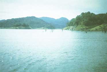
Photo: A.V.R.Massinga
A. LOCATION
- Tete Province, Mozambique.
- 15:29-16:00S, 30:25-32:44E; 314 m above sea level.
B. DESCRIPTION
Cabora Bassa, a new impoundment in the middle Zambezi River, was closed in December 1974, filling rapidly to 12 m below full supply by May 1975. The principal objective of the construction is the production of 3,870 MW of electricity, making Cabora Bassa the largest power-producing barrage in Africa.
The lake, with five basins, lies along a west-east axis almost parallel to prevailing southeasterly winds. Limnological records, from several stations along the lake axis, indicated homoisothermal conditions until September, the hot day season. From then until records ceased in December, thermocline and oxyclines were present in the deeper eastern basins. Hydrogen sulphide was recorded in hypolimnial waters towards the end of the year. Open water of the shallow, wind- and wave-swept eastern basins remained oxygenated throughout the year.
Water transparency increased five-fold from April to December, increasing too from east to west. pH was alkaline becoming more acid in cool winter months and in bottom waters of stratified basins. Conductivity ranged from 95 to 119 micro S cm-1 with higher values in shallow lake margins. Chemical content of surface waters showed little seasonal or spatial variation and was, in general, comparable with pre-impoundment levels.
Duration of the initial 'productive phase' will probably be shorter than Kariba due to more rapid lake water exchange but indications are that productivity will be higher in the maturation phase (1, 5).
C. PHYSICAL DIMENSIONS
| Surface area [km2] | 2,739 |
| Volume [km3] | 55.8 |
| Maximum depth [m] | 157 |
| Mean depth [m] | 20.9 |
| Water level | Regulated |
| Length of shoreline [km] | 246 |
| Residence time [yr] | 0.5 |
| Catchment area [km2] | 56,927 |
D. PHYSIOGRAPHIC FEATURES
D1 GEOGRAPHICAL
- Sketch map: cf. AFR-14-0l.
- Number of outflowing rivers and channels (name)
4 (Luangwa, Hunyani, Messenguerzi and Shire)(l).
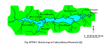
Sketch map (Q).
D2 CLIMATIC (Q)
- Climatic data at Chicoa Basin, 1978
| Jan | Feb | Mar | Apr | May | Jun | Jul | Aug | Sep | Oct | Nov | Dec | Ann. |
| Mean temp. [deg C] | 27.6 | 27.5 | 28 | 27.4 | 25.4 | 23 | 22.4 | 24.4 | 24.5 | 31.1 | 30.2 | 28.3 | 26.9 |
- Water temperature [deg C](8, 3)
| Gonge Basin |
| Depth [m] | Jan | Feb | Mar | Apr | May | Jun | Jul | Aug | Sep | Oct | Nov | Dec | Ann. |
|---|
| 0.5 | - | - | - | - | - | 24.1 | 24.3 | 23.2 | 23.3 | 24.3 | 26.3 | 30.4 | 27 |
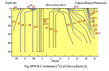
Isotherms [deg C] at Chicoa Basin (3).
E. LAKE WATER QUALITY (Q, 3)
E1 TRANSPARENCY [m]
| Gonge Basin, 1982-1983 |
| Jan | Feb | Mar | Apr | May | Jun | Jul | Aug | Sep | Oct | Nov | Dec |
|---|
| Depth [m] | 2.2 | 3.0 | 2.0 | 1.2 | 1.3 | 1.8 | 0.7 | 0.75 | 0.75 | 1.0 | 1.8 | 1.3 |
E2 pH
| Gonge Basin, 1976 |
| Depth [m] | Jan | Feb | Mar | Apr | May | Jun | Jul | Aug | Sep | Oct | Nov | Dec |
|---|
| 0.5 | - | - | - | - | - | - | 6.9 | 7.0 | 7.7 | 8.3 | 8.7 | 8.0 |
E4 DO [mg l-1]
| Gonge Basin, 1982-1983 |
| Depth [m] | Jan | Feb | Mar | Apr | May | Jun | Jul | Aug | Sep | Oct | Nov | Dec |
|---|
| 5 | 7 | 6 | 8 | 6 | 7 | 7 | 7 | - | - | 7 | 7 | 7-8 |
| 10 | 4 | 4-3 | 5 | 6-5 | - | - | - | - | - | - | 6 | 6 |
| 15 | 3 | - | - | - | - | - | - | - | - | - | - | - |
| 20 | 3 | 2 | 2 | 6-5 | - | - | - | - | - | - | 6 | 4-5 |
| 25 | 3 | - | - | - | - | - | - | - | - | - | - | - |
| 30 | 2-3 | 1-2 | 1 | 6-5 | - | - | - | - | - | - | 5-6 | 4-5 |
| 35 | 2-3 | - | - | - | - | - | - | - | - | - | - | - |
| 40 | 2-3 | 1-2 | 1 | 6-5 | - | - | - | - | - | - | 5-6 | 4-5 |
E7 NITROGEN CONCENTRATION
| Gonge Basin, 1981-1983 |
| Depth [m] | Jan | Feb | Mar | Apr | May | Jun | Jul | Aug | Sep | Oct | Nov | Dec |
|---|
| S* | - | 0.0 | - | 0.01 | 0.0 | - | 0.50 | - | - | 0.18 | - | 0.15 |
* Surface.
E8 PHOSPHORUS CONCENTRATION
| Gonge Basin, 1982-1983 |
| Depth [m] | Jan | Feb | Mar | Apr | May | Jun | Jul | Aug | Sep | Oct | Nov | Dec |
|---|
| 0.5 | - | - | - | 0.02 | 0.13 | - | - | - | - | - | - | - |
F. BIOLOGICAL FEATURES
F1 FLORA
- Floating macrophytes: Eichhornia crassipes, Salvinia molesta (Q, 3).
- Phytoplankton (Q)
June-October, diatoms (Melosira spp., Synedra sp.), green algae (Eudorina sp., Tetrastrum sp., Scenedesmus sp.), flagellates (Trachelomonas sp.); November- December, blue green algae (Mycrocystis sp., Sphaerocystis sp., Anabaena sp., Oscillatoria spp., Lyngbya sp.).
F2 FAUNA (Q, 2, 4, 5, 6)
- Zooplankton
Cladocera (Bosmina longirostris, Diaphanosoma excisum, Ceriodaphnia sp., Daphnia lumholtzi, Moina sp.), Copepoda (Mesocyclops leukarti, Diofsmus sp.), Rotifera (Brachionus calyciflorus, Polyarthra spp., Filinia longiseta, Keratella cochlearis, Keratella sp., Gastropus sp., Kellicottia longispina).
- Fish (Q)
Mormyrus deliciosus*, M. longirostris*, Gnathonemus marcrolepidotus, Hippopotamyrus discorhynopus, Limnothrissa miodon, Anguilla mossambicus, Hydrocynus vittatus*. * Economically important.
F5 FISHERY PRODUCTS (Q)
- Annual sport fish catch [metric tons]
1982: 4,343.
- Fishery products other than fish: None.
G. SOCIO-ECONOMIC CONDITIONS (Q)
G1 LAND USE IN THE CATCHMENT AREA
- Types of important forest or scrub vegetation
Mojave (Colophospermum mojave) and Baobab (Adansonia digitata).
- Main kinds of crops: Maize and cassava.
- Levels of fertilizer application on crop fields: None.
G2 INDUSTRIES IN THE CATCHMENT AREA AND THE LAKE
| No. of person engaged | No. of establishments | Main products or major industries |
|---|
| Primary industry Fisheries | 1,590* | N.A. | N.A. |
* Mainly individual fishermen.
- Number of domestic animals in the catchment area: N.A.
G3 POPULATION IN THE CATCHMENT AREA
| 1987 |
| Population | Population density [km-2] | Major cities (population) |
|---|
| Urban | - | - | Songo |
| Rural | - | - | |
H. LAKE UTILIZATION (Q)
H1 LAKE UTILIZATION
Source of water, navigation and transportation, fisheries and power generation.
I. DETERIORATION OF LAKE ENVIRONMENTS AND HAZARDS (Q)
I1 ENHANCED SILTATION
I2 TOXIC CONTAMINATION
I3 EUTROPHICATION
No eutrophication.
I4 ACIDIFICATION
- Extent of damage: No information.
J. WASTEWATER TREATMENTS (Q)
J1 GENERATION OF POLLUTANTS IN THE CATCHMENT AREA
(a) Pristine lake environments.
J3 SANITARY FACILITIES AND SEWERAGE
- Percentage of municipal population in the catchment area provided with adequate sanitary facilities (on-site treatment systems) or public sewerage: 1%.
K. IMPROVEMENT WORKS IN THE LAKE (Q)
None.
L. DEVELOPMENT PLANS (8, 4, 5, 6)
The construction of a small fishery enterp rise is planned for the near future.
M. LEGISLATIVE AND INSTITUTIONAL MEASURES FOR UPGRADING LAKE ENVIRONMENTS (Q)
M3 RESEARCH INSTITUTES ENGAGED IN THE LAKE ENVIRONMENT STUDIES
- Fisheries Research Institute (1982)
N. SOURCES OF DATA
- Questionnaire filled by Dr. A. V. R. Massinga, Fisheries Research Institute, Maputo, Mozambique.
- Hall, A., Valente, Isabel Maria, C. B. S. & Davis, B. R. (1977) Freshwater Biol., 7: 187-206.
- Bond, W. J., Coe, N., Jackson, P. B. N. & Rogers, K. H. (1978) Ibid., 8: 433-447.
- Bond, W. J. & Roberts, M. G. (1978) Hydrobiologia, 60 : 243-259.
- Branacseic, G. M. & Lopes, S. (1984) Mozambique investigation into the fisheries and limnology of Cabora Bassa Reservoir seven years after dam closure. Sweden Funds-in-Trust, FAO/GCP/MOT/DOG/SWE, Field Document 9.
- Gliwice, Z. M. (1984) Mozambique, limnological study of Cabora Bassa Reservoir with special record to sardine fishery expansion, Sweden Funds in-Trust, FAO/GCP/MOT/DOG/SWE, Field Document 10.
- 6) Vostradvsky, J. (1984) Mozambique, fishery investigations of Cabora Bassa Reservoir. Sweden Funds-in-Trust, FAO/GCP/MOT/DOG/SWE, Field Document 11.

