LAKE GUIERS
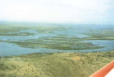
An aerial view of the southern reigon

Photo: F.X.Cogels
A. LOCATION
- Senegal.
- 15:55-16:25N, 15:45-16:00W; 0 m above sea level.
B. DESCRIPTION
The lake is located on the left bank of the Senegal River. It is the largest reserve of surface freshwater in the country.
Embankments have been built at the northern and southern extremities. The lake is connected with the Senegal River by a canal. Its hydrological regime was submitted to the fluvial rising, but is now regulated by the dams constructed on the river.
Its principal uses are: irrigation for sugar cane and production of drinking water. In the future the lake could serve as starting point of a canal to Dakar (250 km) for supplying water the town.
This shallow lake has a lot of similarities with Lake Chad, but its size permits an easier study of the ecosystem (Q).
C. PHYSICAL DIMENSIONS
| Surface area [km2] | 175-280 |
| Volume [km3] | 0.18-0.65 |
| Maximum depth [m] | 2.5 |
| Mean depth [m] | 1.3 |
| Water level | Regulated |
| Normal range of annual water level fluctuation [m] | 2.5 |
| Length of shoreline [km] | 150 |
| Residence time [yr] | 0.5 |
D. PHYSIOGRAPHIC FEATURES
D1 GEOGRAPHICAL (Q)
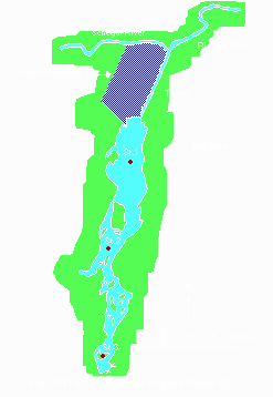
- Sketch map: Fig. AFR-09-0l.
- Number of outflowing rivers and channels (name): 1 (Taoue-canal).
D2 CLIMATIC (Q)
- Climatic data at Richard-Toll*1, 1977-1982
| Jan | Feb | Mar | Apr | May | Jun | Jul | Aug | Sep | Oct | Nov | Dec | Ann. |
| Mean temp. [deg C] | 23 | 24 | 27 | 29 | 30 | 30 | 30 | 29 | 30 | 30 | 26 | 23 | 28 |
| Precipitation [mm]*2 | 3 | 2 | 1 | 4 | 0 | 5 | 43 | 100 | 110 | 5 | 0 | 2 | 275 |
*1 10 km north of the lake. *2 Very irregular.
- Number of hours of bright sunshine: 3,450 hr yr-1.

Sketch map of the lake (Q).
- Water temperature [deg C]
| Station 2, 1977-1982 |
| Depth [m] | Jan | Feb | Mar | Apr | May | Jun | Jul | Aug | Sep | Oct | Nov | Dec |
|---|
| 0.5 | 19 | 21 | 22 | 23 | 24 | 25 | 26 | 28 | 29 | 27 | 23 | 20 |
- Mixing type: Polymictic.
- Notes on water mixing and thermocline formation
Shallow lake and hard wind cause uncommon thermocline formation.
E. LAKE WATER QUALITY
E1 TRANSPARENCY [m](1, 2)
Station 2, 1979-1982: 0.2-0.4*.
* Through out the year.
E2 pH (Q)
| Depth [m] | Jan | Feb | Mar | Apr | May | Jun | Jul | Aug | Sep | Oct | Nov | Dec |
|---|
| Station 1, 1979-1982 |
| 0.5 | - | 7.2 | - | 7.5 | - | 7.1 | - | 7.7 | - | 7.0 | - | 6.9 |
| Station 2, 1979-1982 |
| 0.5 | - | 7.9 | - | 7.3 | - | 7.6 | - | 8.5 | - | 7.2 | - | 7.5 |
| Station 3, 1979-1982 |
| 0.5 | - | 8.3 | - | 7.9 | - | 7.9 | - | 8.4 | - | 7.9 | - | 8.2 |
E3 SS [mg l-1](Q)
| Depth [m] | Jan | Feb | Mar | Apr | May | Jun | Jul | Aug | Sep | Oct | Nov | Dec |
|---|
| Station 1, 1979-1982 |
| 0.5 | - | 75 | - | - | 89 | - | - | - | - | 45 | - | - |
| Statopn 2, 1979-1982 |
| 0.5 | - | 65 | - | - | 60 | - | - | - | - | 48 | - | - |
| Station 3, 1979-1982 |
| 0.5 | - | 30 | - | - | 31 | - | - | - | - | 15 | - | - |
E7 NITROGEN CONCENTRATION [mg l-1](Q)
- Everywhere
NO3-N<2.
NH4-N<0.l.
E8 PHOSPHORUS CONCENTRATION [mg l-1](Q)
E9 CHLORIDE CONCENTRATION [mg l-1](Q)
| Depth [m] | Jan | Feb | Mar | Apr | May | Jun | Jul | Aug | Sep | Oct | Nov | Dec |
|---|
| Station 1, 1979-1982 |
| 0.5 | - | 36 | - | 48 | - | 140 | - | 4 | - | 4 | - | 18 |
| Station 2, 1979-1982 |
| 0.5 | - | 37 | - | 53 | - | 185 | - | 83 | - | 23 | - | 24 |
| Station 3, 1979-1982 |
| 0.5 | - | 240 | - | 325 | - | 1,329 | - | 650 | - | 245 | - | 225 |
- Other ion concentration [mg l-1](Q)
| Depth [m] | Cl- | SO42- | HCO3- | Ca2+ | Mg2+ | Na+ | K+ |
|---|
| 0.50 | 140 | 38 | 167 | 27 | 23 | 95 | 11 |
| 1.00 | 66 | 15 | 111 | 19 | 13 | 44 | 7 |
| 1.50 | 41 | 9 | 85 | 15 | 9 | 26 | 5 |
F. BIOLOGICAL FEATURES
F1 FLORA (1, 3)
1979-1983
- Emerged macrophytes
Aeschynomene elaphroxylon, Vetiveria nigritana, Typha australis, Tamarix
senegalensis, Phragmites australis, Parkinsonia aculeata.
- Floating macrophytes
Nymphaea lotus, Pistia stratiotes, Ludwigia adscendens, Echinochloa stagnina,
Nymphoides ezannoi, Vossia cuspidata.
- Phytoplankton
Ulothrix sp., Euglena sp., Pediastrum clathratum, Anabaena sp., Nitzschia
acicularis, Navicula accomoda, Scenedesmus quadricauda, Merismopedia sp.
F2 FAUNA (1)
1979-1983
- Fish
Tilapia nilotica*, T. aurea*, Clarias senegalensis*, Lates niloticus, Alestes
dentex, Heterotis niloticus, Citharinus citharus, Hydrocyon forskalii, Labeo
senegalensis, Hemichromis bimaculatus.
* Eeconomically important.
- Supplementary notes on the biota
Intermediate host snails of schistosomes: Bulinus guernei, B. forskalii,
Gyraulus sp., Biomphaloria sp., Lymnaea natal.
F5 FISHERY PRODUCTS (1)
- Annual fish catch [metric tons]
1982: 1,650.
- Fishery products other than fish: None.
F7 NOTES ON THE REMARKABLE CHANGES OF BIOTA IN THE LAKE IN RECENT YEARS
Decrease of the fish population has been caused by bad spawning conditions and over-fishing.
G. SOCIO-ECONOMIC CONDITIONS (Q)
G2 INDUSTRIES IN THE CATCHMENT AREA AND THE LAKE
| 1988 |
| No. of persons engaged | No. of establishments | Main products or major industries |
|---|
| Primary industry Fisheries | 280* | | |
| Secondary industry | 8,000 | 1 | Sugar |
* Professional and semi-professional.
G3 POPULATION IN THE CATCHMENT AREA
| Population | Population density [km-2] | Major cities (population) |
|---|
| Urban | N.A. | N.A. | Richard-Toll |
| Rural | 40,000 | N.A. | |
H. LAKE UTILIZATION (Q)
H1 LAKE UTILIZATION
Source of water.
H2 THE LAKE AS WATER RESOURCE
| 1988 |
| Use rate [mill. m3 yr-1] |
|---|
| Domestic | 15 |
| Irrigation | 285 |
I. DETERIORATION OF LAKE ENVIRONMENTS AND HAZARDS (Q)
I1 ENHANCED SILTATION
- Extent of damage: None.
- Supplementary notes: 1 [mm yr-1].
I2 TOXIC CONTAMINATION
- Present status: No information.
L. DEVELOPMENT PLANS (4)
Two new dams have been constructed to regulate the water supply of the Senegal River. That will influence the hydrological regime of the lake. The recent agricultural development (300,000 ha) in the valley will have effects on water quality of the river and of the lake. Any future strategy for managing the quantity and quality of the lake's water should try to reconcile the various interests involved while reducing negative effects as far as possible. A water management mathematical model has been prepared.
M. LEGISLATIVE AND INSTITUTIONAL MEASURES FOR UPGRADING LAKE ENVIRONMENTS
M3 RESEARCH INSTITUTES ENGAGED IN THE LAKE ENVIRONMENT STUDIES
- Institut des Sciences de l'Environnement, Universite de Dakar, Senegal
- Fondation Universitaire Luxembourgeoise, Arlon, Belgium
- ORSTOM, Dakar, Senegal
N. SOURCES OF DATA
- Questionnaire filled by Dr. F. X. Cogels, Fondation Universitaire,Luxembourgeoise, Arlon, Belgium.
- Cogels, F. X. (1984) Etude limnologique d'un lac sahelien, le lac de Guiers (Senegal). Ph. D. Thesis FUL, Arlon, Belgium. 329 pp.
- Cogels, F. X. & Gac, J. Y. (1986) Etude chimique des eaux du lac de Guiers et de leur evolution annuelle. Geodynamique, 1 (2): 121-134.
- Dia, A. (1982) Le phytoplancton du lac de Guiers, approche qualitative et quantitative. Cah. ORSTOM, ser. Biol., 45: 35-47.
- Gac, J. Y. & Cogels, F. X. (1986) An assessment of the impact on Lac de Guiers by dam construction on the Senegal River. Water Quality Bulletin, 11 (2): 82-87.


