
LAKE VICTORIA
Fishing boats on the lakeshore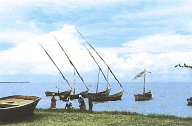
Photo: M.Nakashima
A. LOCATION
- Mara, Muwanza and West Lake, Tanzania; North Buganda, South Buganda and Busoga, Uganda; and Nyanza and Western, Kenya.
- 0:21N-3:00S, 31:39-34:53E; 1,134 m above sea level.
B. DESCRIPTION
-
Lake Victoria, the largest of all African Lakes, is also the second widest freshwater body in the world. Its extensive surface belongs to the three countries; the northern half to Uganda, the southern half to Tanzania, and part of the northeastern sector to Kenya. The lake occupies a wide depression near the equator, between the East and West Great Rift Valleys, but its drainage basin is relatively small, being slightly less than three times the lake's surface in area. The lake water is drained at a rate of about 600 m3 sec-1, at Jinja on the northern shore, into the Victoria Nile which flows northward via Lake Albert and the White Nile forming the uppermost reaches of the Nile River.
The lake shore is highly indented, and there are many isles in the lake, some of which, especially the Sesse Group, are known for their beautiful landscape, health resorts and sightseeing places. Abundant prehistoric remains found around the lake indicate the early development of agriculture. There are a number of coastal towns such as Kisumu (Kenya), Entebe (Uganda), Bukoba, Muwanza and Musoma (Tanzania), connected with each other by ship routes and also to the cities of the Indian Ocean coast by railways. The dam constructed in 1954 at Owen Falls on the Victoria Nile supplies electricity and water for various uses in Uganda and Kenya.
C. PHYSICAL DIMENSIONS (Q1, 1)
| Surface area [km2] | 68,800 |
| Volume [km3] | 2,750 |
| Maximum depth [m] | 84 |
| Mean depth [m] | 40 |
| Water level | Regulated |
| Length of shoreline [km] | 3,440 |
| Residence time [yr] | 23 |
| Catchment area [km2] | 184,000 |
D. PHYSIOGRAPHIC FEATURES
D1 GEOGRAPHICAL- Bathymetric map: Fig. AFR-05-01.
- Names of main islands: Ukerewe, Sesse, Ukara, Kome, Lolui and Mfanganu (3).
- Number of outflowing rivers and channels (name): 1 (Victoria Nile R.)(Q1).
- Climatic data at Kisumu (Q1)
| Jan | Feb | Mar | Apr | May | Jun | Jul | Aug | Sep | Oct | Nov | Dec | Ann. | |
|---|---|---|---|---|---|---|---|---|---|---|---|---|---|
| Mean temp. [deg C]*1 | 24.0 | 23.6 | 23.9 | 23.2 | 23.1 | 23.3 | 21.8 | 22.1 | 22.8 | 23.4 | 23.3 | 23.3 | 23.1 |
| Precipitation [mm]*2 | 57 | 70 | 160 | 195 | 177 | 101 | 68 | 96 | 79 | 64 | 106 | 105 | 1,278 |
- Solar radiation: 17.63 MJ m-2 day-1 (Q1).
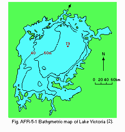
Bathymetric map (2).
- Water temperature: Fig. AFR-05-02.
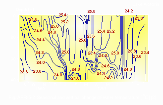
Seasonal and vertical change of water temperature [deg C](2).
- Freezing period: None (2).
- Mixing type: Monomictic (2).
- Notes on water mixing and thermocline formation
E. LAKE WATER QUALITY
E1 TRANSPARENCY [m](5)| Station 34, 1985 | |||||||||||||
| Jan | Feb | Mar | Apr | May | Jun | Jul | Aug | Sep | Oct | Nov | Dec | ||
|---|---|---|---|---|---|---|---|---|---|---|---|---|---|
| Depth [m] | - | - | - | - | - | - | - | - | 1.5 | 1.3 | - | - | |
| Depth [m] | Station 32, 1985 | ||||||||||||
| - | - | - | - | - | - | - | - | 1.9 | 1.3 | - | - | ||
| Depth [m] | Station 103, 1985 | ||||||||||||
| - | - | - | - | - | - | - | - | 2.5 | 1.6 | - | - | ||
| Depth [m] | Station 105, 1985 | ||||||||||||
| - | - | - | - | - | - | - | - | 1.2 | 0.9 | - | - | ||
| Depth [m] | Station 53, 1985 | ||||||||||||
| - | - | - | - | - | - | - | - | 0.85 | 0.5 | - | - | ||
| Station 51, 1985 | |||||||||||||
| Depth [m] | - | - | - | - | - | - | - | - | 1.1 | 0.8 | - | - | |
| Station 34, 1986 | |||||||||||||
| Depth [m] | - | 0.2 | - | - | 1.4 | - | - | - | - | - | - | - | |
| Station 32, 1986 | |||||||||||||
| Depth [m] | - | 0.6 | - | - | - | - | - | - | - | - | - | - | |
| Station 103, 1986 | |||||||||||||
| Depth [m] | - | 1.1 | - | - | 1.7 | - | - | - | - | - | - | - | |
| Station 105, 1986 | |||||||||||||
| Depth [m] | - | 0.6 | - | - | - | - | - | - | - | - | - | - | |
| Station 53, 1986 | |||||||||||||
| Depth [m] | - | 0.3 | - | - | 0.5 | - | - | - | - | - | - | - | |
| Station 51, 1986 | |||||||||||||
| Depth [m] | - | 0.4 | - | - | 0.8 | - | - | - | - | - | - | - | |
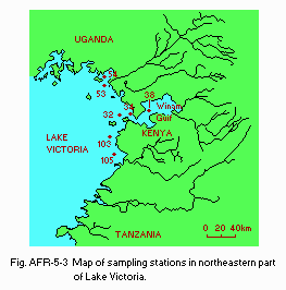
Map of sampling stations in northeastern part of Lake Victoria.
E2 pH (Q2) Winam Gulf: 8.4 (December 1976) and 8.1 (February 1977). E3 TURBIDITY [NTU](5)
| Station 34, 1985 | ||||||||||||
| Jan | Feb | Mar | Apr | May | Jun | Jul | Aug | Sep | Oct | Nov | Dec | |
|---|---|---|---|---|---|---|---|---|---|---|---|---|
| Depth [m] | - | - | - | - | - | - | - | - | 3.6 | 4.1 | - | - |
| Station 32, 1985 | ||||||||||||
| Depth [m] | - | - | - | - | - | - | - | - | 2.6 | 3.2 | - | - |
| Station 103, 1985 | ||||||||||||
| Depth [m] | - | - | - | - | - | - | - | - | 1.5 | 1.7 | - | - |
| Station 105, 1985 | ||||||||||||
| Depth [m] | - | - | - | - | - | - | - | - | 8.8 | - | - | - |
| Station 53, 1985 | ||||||||||||
| Depth [m] | - | - | - | - | - | - | - | - | 10.4 | 33.7 | - | - |
| Station 51, 1985 | ||||||||||||
| Depth [m] | - | - | - | - | - | - | - | - | 14.7 | - | - | - |
| Station 34, 1986 | ||||||||||||
| Depth [m] | - | 21.7 | - | - | 4.1 | - | - | - | - | - | - | - |
| Station 32, 1985 | ||||||||||||
| Depth [m] | - | 6.5 | - | - | - | - | - | - | - | - | - | - |
| Station 103, 1985 | ||||||||||||
| Depth [m] | - | 3.2 | - | - | 2.5 | - | - | - | - | - | - | - |
| Station 105, 1985 | ||||||||||||
| Depth [m] | - | - | - | - | 9.7 | - | - | - | - | - | - | - |
| Station 53, 1985 | ||||||||||||
| Depth [m] | - | 12.3 | - | - | 4.7 | - | - | - | - | - | - | - |
| Station 51, 1985 | ||||||||||||
| Depth [m] | - | - | - | - | 19.0 | - | - | - | - | - | - | - |
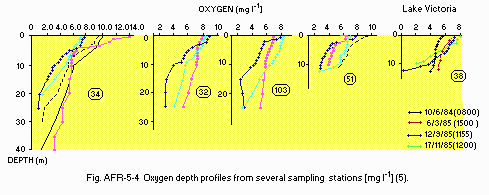
Oxygen depth profiles from several sampling stations [mg l-1](5).
E5 BOD [mg l-1](Q2)
- Winam Gulf: 16-86.
- Winam Gulf, September 1985
| Depth[m] | Station 6 | Station 31 | Station 32 |
|---|---|---|---|
| 0 | 20.3 | 15.9 | 17.5 |
| 0.5 | 15.9 | 12.9 | 13.6 |
| 1 | 22.3 | 10.4 | 13.3 |
| 2 | 20.1 | 15.9 | 10.7 |
| 3 | 23.5 | 18.5 | 7.8 |
| 4 | 19.0 | 21.4 | 5.0 |
| 10 | 10.4 | 4.7 | |
| 15 | 15.5 | 4.7 | |
| 20 | 7.3 | 2.9 | |
| 25 | 9.6 | 2.6 | |
| 30 | 1.8 |
- NH4-N [mg l-1] Winam Gulf, September 1985
| Depth [m] | Station 6 | Station 31 | Station 32 | Station 103 |
|---|---|---|---|---|
| 0 | 0.2 | 0.35 | 0.7 | 0.35 |
| 0.5 | - | - | - | 0.15 |
| 1 | - | 0.40 | - | 0.15 |
| 2 | - | - | - | |
| 3 | - | N.D. | - | |
| 4 | - | - | - | |
| 10 | - | - | ||
| 15 | 0.35 | 0.4 | ||
| 20 | 0.30 | - | ||
| 25 | - | - | ||
| 30 | - | 0.35 |
- NO3-N [mg l-1] Winam Gulf, September 1985
| Depth [m] | Station 6 | Station 31 | Station 32 | Station 103 | ||
|---|---|---|---|---|---|---|
| 0 | 0.1* | 0.1* | 0.1* | 0.1* | ||
| 0.5 | - | - | - | 0.1* | ||
| 1 | - | 0.1* | - | 0.1 | ||
| 2 | - | - | - | |||
| 3 | - | 0.1* | - | |||
| 4 | - | - | - | |||
| 10 | - | - | ||||
| 15 | 0.1 | 0.1* | ||||
| 20 | 0.1 | - | ||||
| 25 | - | - | ||||
| 30 | 0.2 |
- PO4-P [mg l-1] Winam Gulf, September 1985
| Depth [m] | Station 6 | Station 31 | Station 32 | Station 103 |
|---|---|---|---|---|
| 0 | N.D. | 0.002* | 0.002* | 0.002 |
| 0.5 | - | - | - | 0.002 |
| 1 | - | 0.002* | - | 0.006 |
| 2 | - | 0.002* | - | |
| 3 | - | 0.002* | - | |
| 4 | - | - | - | |
| 10 | - | - | ||
| 15 | 0.003 | 0.002* | ||
| 20 | 0.003 | - | ||
| 25 | - | - | ||
| 30 | 0.01 |
| Winam Gulf | |
| December 1976 | 21 |
| February 1977 | 9.5 |
F. BIOLOGICAL FEATURES
F1 FLORA (Q1)- Emerged macrophytes
Typha spp., Phragmites spp., Cyperus papyrus, Potamogeton spp. - Floating macrophytes: Vossia.
- Submerged macrophytes
Ceratophyllum demersum, Hydrilla verticillata, Polygonum spp. - Phytoplankton
Melosira nyassensis, Lyngbya contorta, Spirulina spp., Anabaena spp., scillatoria spp., Pediastrum clathratum, Fragillaria spp., Cyclotella spp., cenedesmus spp., Glenodinium spp.
- Zooplankton
Daphnia spp., Chydorus sp., Leptodora sp., Cyclops sp., Diaptomus, Caridina nilotica, Philodina spp., Keratella sp., Asplanchna brightwelli, Limnocnida victoriae. - Benthos
Melania tuberculata, Bellamysa sp., Corbicula sp., Caelatura sp., Chaoborus sp., Chironomus sp. - Fish Lates
niloticus, Tilapia spp.*, Haplochromis spp., Labeo victorianus, Alestes baremose*, Clarias spp., Bagrus docmac, Protopterus aethiopicus, Barbus*, Scibe*.
* Economically important.
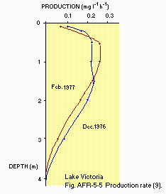
Production rate (9).
F4 BIOMASS (6)
- Fish [kg (fresh wt.) ha-1] 1974: 80.
- Annual fish catch [metric tons] 1980: 120,000.
-
An introduced species, Nile perch (Lates niloticus), dominates fishery products within the Kenyan portion of the lake. Traditional fishery have overfished tilapias and riverine species.
G. SOCIO-ECONOMIC CONDITIONS (Q2)
G1 LAND USE IN KENYAN PART OF THE CATCHMENT AREA| 1985 | ||
| Area [km2] | [%] | |
|---|---|---|
| Natural landscape | 29,500 | 62 |
| - Woody vegetation | 7,000 | 15 |
| - Herbaceous vegetation | 22,500 | 47 |
| Agricultural land | 15,500 | 32 |
| - Crop field | 11,000 | 23 |
| - Pasture land and fallow land | 4,500 | 9 |
| Residential area and others | 2,700 | 6 |
| Total | 47,700* | 100 |
- Main types of woody vegetation
Savanna woodland (Acacia, Albizzia and Butyrospermum). - Main species of herbaceous vegetation
Cymbopogon, Hyparrhenia, Londetia and Cyperus papyrus. - Main kinds of crops
Maize, cotton, sisal, tobacco, beans, sugar cane, coffee, sorghum, millet, wheat and root crops (cassava, etc.). - Levels of fertilizer application on crop fields: Light.
- Trends of change in land use
Decrease of forest areas due to very high population pressure and resultant excessive cultivation.
| 1985 | ||
| Gross product per year [mill. K£*2 | Main products ormajor industries | |
|---|---|---|
| Primary industry | ||
| -Cash crops | 89 | Value Coffee, tea, cotton, sugarcane |
| -Animal husbandry | 97 | added Milk, meat |
| -Fisheries*3 | 10 | Nile perch, tilapia |
| -Staple crops | 181 | |
| Secondary industry | 400 Gross | Coffee & tea processing, sugar, pulp, dairy product, foods, leather, textile |
| 1985 | |||
| Population | Populationdensity [km-2] | Major cities (population) | |
|---|---|---|---|
| Urban | 630,000 | ||
| Rural | 7,480,000 | Kisumu, Eldoret | |
| Total | 8,110,000 | 170 | |
H. LAKE UTILIZATION (Q2)
H1 LAKE UTILIZATION- Source of water, navigation and transportation, recreation (yachting), and fisheries.
| 1986 | |
| Use rate [m3 sec-1] | |
|---|---|
| Domestic | 0.17 (for Kisumu) |
| Irrigation | 1.7 (near Kisumu) |
I. DETERIORATION OF LAKE ENVIRONMENTS AND HAZARDS
I1 ENHANCED SILTATION- Extent of damage (Q2): Not serious.
- Supplementary notes (7): 4,000,0000 [t yr-1] from 47,000 km2 of catchment (an estimate); 0.5-1.0 [mm yr-1] as lake sediment.
- Present status (Q2): Detected but not serious.
- Main contaminants, their concentrations and sources (7) 1984
| Kisumu Bay of Winam Gulf | ||
| Name of contaminants | Concentrations [ppb] Fish* | Main Sources |
|---|---|---|
| DDE | 4.3 | Pesticide |
- Environmental quality standards for contaminants in the lake (Q2)
Now follow WHO ambient standards. - Supplementary notes (8)
Nzoia River draining into the lake is contaminated with pesticide residues; DDT 0.3 ppm, DDE 0.3 ppm, BHC 0.2 ppm, Toxaphene 0.2 ppm in 1982.
- Nuisance caused by eutrophication* (7)
Unusual algal bloom: Microcystis aeruginosa, Anabaena circinalis.
* In Winam Gulf. - Supplementary notes (8)
Mesotrophic in the main body of the lake. Although nutrient loads to the lake are not known, 400 kg m-2 yr-1 of T-N and 20 kg km-2 yr-1 of T-P are measured as averages of 24 points in the watershed of Nzoia River, a major tributary of the lake.
J. WASTEWATER TREATMENTS (Q2)
J1 GENERATION OF POLLUTANTS IN THE CATCHMENT AREA*(d)- Measurable pollution with limited wastewater treatment.
* In Kenyan part.
- Municipal wastewater treatment systems
No. of municipal wastewater treatment systems: 4 (trickling filter plants, oxidation ponds). - Industrial wastewater treatment systems
Anaerobic ponds and aerobic oxidation ponds are used by very many factories (sugar, textile, dairy and paper factories).
K. IMPROVEMENT WORKS IN THE LAKE (Q2)
- None.
L. DEVELOPMENT PLANS (Q2)
-
An integrated regional development master plan for 1987-2005 is being drawn up by the Lake Basin Development Authority (Kenya) for agricultural, industrial, livestock, fishery and infrastructure developments.
M. LEGISLATIVE AND INSTITUTIONAL MEASURES FOR UPGRADING LAKE ENVIRONMENTS (Q2)
M1 NATIONAL AND LOCAL LAWS CONCERNED*- Names of the laws
- The Water Act
- The Public Health Act
- The Poisonous Substance Act (indirect)
- The Pesticides Control Act (indirect)
- Responsible authorities
- Ministry of Water Development
- Ministry of Health
- Main items of control
- Sewage effluent and industrial effluent
- Ministry of Water Development, Nairobi, Kenya
- Marine Fishery Development, Kisumu, Kenya
- Lake Basin Development Authority, Kisumu, Kenya
* Kenya only.
- Kenya Marine Fisheries Research Institute, Kisumu
- Tanzania Freshwater Fisheries Research
- Uganda Freshwater Fisheries Research Organization, Jinja
- Lake Basin Development Authority, Kisumu
N. SOURCES OF DATA
- Questionnaire filled by Dr. P. B. 0. Ochumba, Kisumu Laboratory, Kisumu. (Q1)
- Questionnaire filled by Dr. M. Nakashima, International Development Centre, Tokyo. (Q2)
- Serruya, C. & Pollinger, U. (1983) Lakes of the Warm Belt. p. 569. Cambridge University Press, Cambridge.
- Talling, J. F. (1957) Comparative problems of phytoplankton production and photosynthetic productivity in a tropical and temperate lake. Mem. Ist. Idrobiol., 18, Suppl.: 339-424.
- Shimonaka, K. (ed.)(1984) Grand World Atlas (Sekai Dai Chizu-cho). p. 273. Heibon-sha, Tokyo.*
- Payne, A. I. (1986) The Ecology of Tropical Lakes and Rivers. John Wiley and Sons Ltd., New York.
- Ochumba, P. B. O. (1987) Water Quality Bulletin, 12(3): 119-122.
- Ssentongo, G. W., Durand, J. R. & Harbott, B. (1981) The rational exploitation of African aquatic ecosystems. The Ecology and Utilization of African Inland Waters (ed. Symoens, J. J., Burgis, M. & Gaudet, J. J.), pp. 167-175. United Nations Environment Programme, Nairobi.
- Lake Basin Development Authority (1985) The Technical Annex to the Final Report on the Current and Future Implications of Development to the Aquatic Environment of Lake Victoria.
- Chabeda, P. I. M. (1983) A Survey of Eutrophication and Water Pollution Load in Four Rivers of the Northern Half of the Lake Basin Development Authority.
- Water Quality and Pollution Control Section (1978) Limnological Investigation of Lakes in Kenya 1976-1977. Technical Report No. 6. Resource Section, Water Department of Kenya, Nairobi.
* Printed in Japanese. The title is tentatively translated into English with the original title in romanized Japanese in parentheses.
