UST-ILIMSKOYE RESERVOIR
A view of the Ship Island on the lake
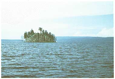
Photo: I.N.Varfolomeeva
A. LOCATION
- Irkutsk Region, Russia.
- 56:25-58:00N, 101:25-104:00E; 296 m above sea level.
B. DESCRIPTION (Q)
The Ust-Ilimskoye Reservoir is the third reservoir (after Irkutskoye and Bratskoye) of the Angara cascade of reservoirs. It is situated 837 km from the Angara mouth and consists of two parts which are located on the rivers Angara and Ilim.
The general planner of this reservoir was the Institute "Hydroproject" (Moscow). The man-made lake was filled in October 1974. The Ust-Ilimskoye Reservoir is of the channel type and has seasonal storage regulation. Its water resources are widely used for electric power production, transportation and navigation, fisheries, timber-rafting and recreation.
The drainage basin of this man-made lake is situated on the Sredne-Sibirskoye plateau. The sedimentary cover of the plateau consists of the Paleozoic, Mesozoic and Cenozoic rocks. The volcanic rocks are widely spread on the reservoir's coasts.
The total cost of the power plant with the reservoir was 1,257 million rubles, the cost of the reservoir being 127.89 million rubles (in current prices at 1974)(Q, 1).
C. PHYSICAL DIMENSIONS
| Surface area [km2] | 1,920 |
| Volume [km3] | 58.9 |
| Maximum depth [m] | 97 |
| Mean depth [m] | 30.7 |
| Water level | Regulated |
| Normal range of annual water level fluctuation [m] | 2.43 |
| Length of shoreline [km] | 4,000 |
| Residence time [yr] | 0.58 |
| Catchment area [km2] | 785,080 (49,000*) |
* The part of the catchment area between the dams of Bratsk and Ust- Ilim hydroelectric power plants.
D. PHYSIOGRAPHIC FEATURES
D1 GEOGRAPHICAL
- Bathymetric map: Fig. ASI-60-1.
- Number of outflowing rivers and channels (name): 1 (Angara R.).
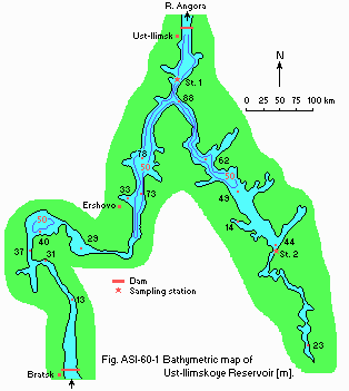
Fig. ASI-60-1
Bathymetric map [m].
D2 CLIMATIC (Q)
- Climatic data at Ershovo, 1985 1989
| Jan | Feb | Mar | Apr | May | Jun | Jul | Aug | Sep | Oct | Nov | Dec | Ann. |
| Mean temp. [deg C] | -22.9 | -20.8 | -11.5 | -1.3 | 7.0 | 13.3 | 15.6 | 14.6 | 7.7 | -0.7 | -11.0 | -19.6 | -2.6 |
| Precipitation [mm] | 20.5 | 12.3 | 18.6 | 19.3 | 33.0 | 44.8 | 64.9 | 68.5 | 26.8 | 27.1 | 23.4 | 19.6 | 379 |
- Number of hours of bright sunshine: 1,847 hr yr-1.
- Solar radiation: 10.2 MJ m-2 day 1.
- Water temperature [deg C]
| Station 1, 1985 |
| Depth [m] | Jan | Feb | Mar | Apr | May | Jun | Jul | Aug | Sep | Oct | Nov | Dec |
| 0.1 | 4.8 | 15.6 | 18.1 | 11.7 | 5.9 | - | - |
| 2 | - | - | - | - | - | 4.6 | 14.6 | 17.7 | 11.8 | 6.0 | - | - |
| 5 | - | - | - | - | - | 4.2 | 12.4 | 17.2 | 11.8 | 6.0 | - | - |
| 10 | - | - | - | - | - | 3.8 | 9.0 | 12.2 | 11.5 | 6.0 | - | - |
| 15 | - | - | - | - | - | 3.8 | 6.2 | 8.6 | 10.9 | 6.0 | - | - |
| 20 | - | - | - | - | - | 3.6 | 5.6 | 7.2 | 9.6 | 6.0 | - | - |
| 30 | - | - | - | - | - | 3.5 | 5.3 | 6.0 | 7.5 | 6.0 | - | - |
| 50 | - | - | - | - | - | 3.4 | 4.3 | 4.8 | 5.7 | 5.9 | - | - |
| 66 | - | - | - | - | - | 3.3 | 4.0 | 4.4 | 4.9 | 5.2 | - | - |
| N* | 3.0 | 3.9 | 4.2 | 4.7 | 5.1 | - | - |
* Near bottom.
| Station 2, 1985 |
| Depth [m] | Jan | Feb | Mar | Apr | May | Jun | Jul | Aug | Sep | Oct | Nov | Dec |
| 0.1 | - | 0.0 | 0.0 | 0.4 | - | 5.1 | 18.1 | 21.4 | 16.1 | 12.5 | - | 0.3 |
| 2 | - | 0.4 | 0.2 | 0.8 | - | 5.0 | 16.8 | 19.3 | 16.0 | 12.6 | - | 0.7 |
| 5 | - | 0.8 | 0.5 | 1.0 | - | 4.9 | 16.2 | 18.7 | 16.0 | 12.6 | - | 0.8 |
| 10 | - | 1.7 | 1.1 | 1.4 | - | 4.5 | 12.0 | 16.1 | 15.9 | 12.6 | - | 1.3 |
| 15 | - | 2.2 | 1.6 | 1.8 | - | 4.2 | 8.0 | 10.7 | 13.6 | 12.2 | - | 2.0 |
| 20 | - | 2.2 | 1.9 | 2.0 | - | 4.2 | 6.4 | 8.3 | 10.3 | 11.1 | - | 2.4 |
| 30 | - | 2.0 | 1.4 | 1.3 | - | 3.6 | 4.6 | 5.4 | 5.8 | 6.3 | - | 3.6 |
| N* | - | 2.1 | 1.8 | 2.0 | - | 2.6 | 4.4 | 4.8 | 5.5 | 6.2 | - | 3.7 |
* Near bottom.
- Freezing period
10 October 10 November till 20 April 10 May, 135 226 days.
- Mixing type: Dimictic.
E. LAKE WATER QUALITY
E1 TRANSPARENCY [m](2)
| Mean for the whole reservoir, 1985 |
| Spring | Summer | Autumn |
| 3.8 | 2.3 | 4.1 |
E2 pH
Mean for the whole reservoir, 1985: 7.3 7.5.
E3 SS [mg 1]
Mean for the whole reservoir, 1985: 93 315.
E4 DO [mg 1]
| Whole reservoir, 1990 |
| Mean | Min. | Max. |
| 11.1 | 2.69 | 16.4 |
E5 COD [mg 1](3)
Determined by KMnO4 method.
Mean for the whole reservoir, 1990: 2.77 35.63.
E6 CHLOROPHYLL CONCENTRATION [mg m-3](3)
Mean for the whole reservoir, 1990: 1.70 50.2.
E7 NITROGEN CONCENTRATION [mg l-1]
| Whole reservoir, 1989 |
| Mean | Min. | Max. |
| NH4-N | 0.06 | 0.00 | 0.54 |
| NO2-N | 0.002 | 0.00 | 0.028 |
| Whole reservoir, 1990 |
| Mean | Min. | Max. |
| NH4-N | 0.09 | 0.00 | 0.95 |
| NO2-N | 0.002 | 0.00 | 0.038 |
E8 PHOSPHORUS CONCENTRATION (Q)(2)
| Whole reservoir, 1978 1983 [mg l-1] |
| Mean | Min. | Max. |
| PO4-P | 0.036 | 0.001 | 0.46 |
F. BIOLOGICAL FEATURES
F1 FLORA
- Phytoplankton (dominant species)
Fragilaria crotonensis, Asterionella formosa, Stephanodiscus hantzschii, S. hantzschii var. pusillus, S. hantzschii var. hantzschii, S. astraca, Tabellaria fenestrata, Melosira granulata var. granulata, Synedra ulna var. danica, Chroomonas acuta, Ceratium hirundinella, Gymnodinium coeruleum, Cryptomonas rostrata, C. marssonii, C. reflexa, Aphanizomenon flos-aquae, Anabaena flos-aquae, A. spiroides f. meyeriana (2).
F2 FAUNA (2)
- Zooplankton
Notholca olchonensis, N. grandis, N. restospina, N. acuminata, Keratella quadrata, K. cochlearis, Kellicottia longispina, Synchaeta pectinata, S. lakowitziana, Conochilus unicornis, Polyarthra dolichoptera, P. major, Asplanchna priodonta, Cyclops kolensis, Mesocyclops leuckarti, Eudiaptomus graciloides, Heterocope appendiculata, Daphnia longispina, Bosmina longirostris, Ceriodaphnia quadrangula.
- Fish
Coregonus lavarentus, C. tugun, Thymallus arcticus arcticus, Esox lucius, Rutilus lacustris, Leuciscus leuciscus baicalensis, Phoxinus phoxinus, Lota lota, Perca fluviatilis, Gymnocephalus cernua, Cottus kessleri.
F3 PRIMARY PRODUCTION RATE [g O2 m-2 day 2](2)
Mean for the whole reservoir, 1980
| Jun-Oct |
| Net production | 722 |
| Dark respiration | 392 |
| Gross production | 1,114 |
F4 BIOMASS
- Biomass of phytoplankton (2)
| Mean for the whole reservoir [g m-3] |
| Year | Spring | Summer | Autumn |
| 1972 | 7 | 2 | 0.1 |
| 1973 | 2 | 2 | 0.5 |
| 1974 | 1 | 5 | 0.5 |
| 1975 | 10 | 90 | 10.0 |
| 1976 | 5 | 45 | 2.5 |
| 1977 | 15 | 70 | 2.5 |
| 1978 | 8 | 67 | 3.0 |
| 1979 | 15 | 73 | 4.0 |
| 1980 | 22 | 72 | 12.0 |
| 1981 | 15 | 37 | 20.0 |
| 1982 | 13 | 37 | 10.5 |
| 1983 | 20 | 34 | 11.7 |
| 1984 | 142 | 50 | 22.0 |
| 1985 | 120 | 142 | 25.0 |
| Mean for the whole reservoir, depth 10 m [mg m-3] |
| Year | Jan | Feb | Mar | Apr | May | Jun | Jul |
| 1976 | - | 6.3 | 34.6 | - | - | 924.5 | - |
| 1977 | - | - | - | - | - | 125.7 | - |
| 1979 | - | 49.0 | - | - | - | - | 1,230.5 |
| 1980 | - | - | - | - | - | 181.6 | 688.1 |
| 1982 | - | - | - | - | - | 185.5 | - |
| Year | Aug | Sep | Oct | Nov | Dec |
| 1976 | 554.1 | 327.4 | - | - | - |
| 1977 | 673.4 | - | 296.7 | - | - |
| 1979 | 996.6 | - | 525.0 | - | - |
| 1980 | 2,321.3 | 810.2 | 365.7 | - | - |
| 1982 | 1,908.6 | - | 477.4 | - | - |
F5 FISHERY PRODUCTS (3)
- Annual fish catch [kg ha-1]
1980 1984: 2 6.
G. SOCIO-ECONOMIC CONDITIONS
G1 LAND USE IN THE CATCHMENT AREA (4) (1981)
| Area [km2] | [%] |
| Natural landscape |
| - Woody vegetation | 47,530 | 97 |
| - Swamp | 1,176 | 2 |
| Agricultural land | 294 | 1 |
| Total | 49,000 | 100 |
- Types of important forest vegetation: Pine, fir, silver-fir, larch.
- Main kinds of crops: Spring wheat.
- Levels of fertilizer application on crop fields: Moderate.
G2 INDUSTRIES IN THE CATCHMENT AREA AND THE LAKE (4)
1981: 70,000 peoples are employed in industries.
G3 POPULATION IN THE CATCHMENT AREA* (7) (1984)
| Population | Population density [km 2] | Major cities |
| Urban | 105,000 |
| Rural | 34,000 | 0.68 | Ust-Ilimsk |
| Total | 139,000 | 2.84 |
* Part of the catchment area between the dams of Bratsk and Ust-Ilim hydroelectric power plants.
H. LAKE UTILIZATION
H1 LAKE UTILIZATION
Water supply of Ust-Ilimsk and Zheleznogorsk cities, navigation (3,500 passengers per year in 1984), transportation (1,170,000 tons in 1984), timber rafting (1,121,000 m3 in 1984), and recreation (capacity of long-rest resort houses, 505 persons; swimming, sport fishing).
H2 THE LAKE AS WATER RESOURCE (2) (1984)
| Use rate [1.0E+6 m3 yr-1] |
| Power plant | 99,650 |
I. DETERIORATION OF LAKE ENVIRONMENTS AND HAZARDS
I1 ENHANCED SILTATION
- Extent of damage: Not serious.
- Supplementary notes
Erosion of the banks varies from 50 m to 200 m during 25 years in different parts of the reservoir.
I2 TOXIC CONTAMINATION
- Present status: Serious.
- Main contaminants, their concentrations and sources (Q)
Mean for the whole reservoir, 1990
| Name of contaminant | Range of concentrations in water [mg l-1] | Main sources |
| Mean | Max. |
| Phenol | 0.001 | 0.012 | Submerged trees |
| Oil products | 0.13 | 1.25 | Navigation and transportation |
| BOD | 1.52 | 5.77 | Submerged trees |
| NH4 | 0.009 | 0.95 | Industry |
| NO2 | 0.002 | 0.038 | Industry |
| Methylmercaptan | 0.008 | 0.149 | Industry |
| Formaldehyde | 0.032 | 0.219 | Industry |
| Lignin | 3.96 | 29.2 | Industry |
I3 EUTROPHICATION
- Nuisance caused by eutrophication
Unusual algal bloom (dominant species of algae: Anabaena flos-aquae, Aphanizomenon flos-aquae); harms to fishery products; low concentration of O2 (hydrosulphide zones, areas with secondary pollution).
- Nitrogen and phosphorus loadings to the lake [t yr-1] (1990)
T-N: 2,946,200.
T-P: 388,700.
I4 ACIDIFICATION
J. WASTEWATER TREATMENTS
J1 GENERATION OF POLLUTANTS IN THE CATCHMENT AREA (Q)
(d) Measurable pollution with limited wastewater treatment.
J2 APPROXIMATE PERCENTAGE DISTRIBUTION OF POLLUTANT LOADS
| [%] |
| Non-point sources (submerged trees) 40 |
| Point sources |
| - Municipal | 10 |
| - Industrial | 50 |
| Total | 100 |
K. IMPROVEMENT WORKS IN THE LAKE
K3 OTHERS (Q)
Cleaning the reservoir from submerged and floating trees; reinforcing shorelines to prevent erosion.
M. LEGISLATIVE AND INSTITUTIONAL MEASURES FOR UPGRADING LAKE ENVIRONMENTS
M1 NATIONAL AND LOCAL CONCERNED
- Responsible authorities
- The administration for the rational utilization of the Ust-Ilimskoye Reservoir
- Roskomgidromet
- Ministry of Energy, Russia
- Main items of control
- Determination of permissible degrees of the parameters of water pollution.
- Monitoring of quality and quantity of surface waters.
M3 RESEARCH INSTITUTES ENGAGED IN THE LAKE ENVIRONMENT STUDIES
- The State Hydrological Institute, St. Petersburg
- Bratsk Hydrometeorological Observatory
N. SOURCES OF DATA
- Questionnaire filled by Dr. T. P. Gronskaya, Ms. T. E. Litova, Ms. I. Varfolomeeva, State Hydrological Institute, St. Petersburg, Russia.
- The Reservoirs of Siberia (Angara-Enisei drainage basin) (1987) 280 pp. Krasnoyarsk.
- Biology of the Ust-Ilimskoye Reservoir (1987) Novosibirsk.
- Geological and Ecological Predictions (1984) 250 pp. Novosibirsk.
- Atlas of the USSR (1984) 260 pp. Moscow.
* Publications cited were printed in Russian. The titles are tentatively translated into English.

