
KRASNOYARSKOYE RESERVOIR
A view on the lake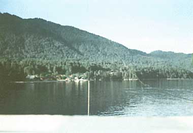
Photo: V.G.Drabkova
A. LOCATION
- Krasnoyarsky District, Russia.
- 53:40-56:00N, 90:50-92:35E; 243 m above sea level.
B. DESCRIPTION
-
Krasnoyarskoye Reservoir on the Enisei River is one of the largest man-made lakes of river origin in Siberia. It is situated at a distance of 2,502 km from the Enisei mouth. The construction of the reservoir started in 1967 and its live storage was filled in 1970. The cost of the project development and the construction of hydroelectric power plant and the reservoir was 802.66 million rubles including 132.56 million rubles for the lake itself. The back- water from the dam extends for a distance of 386 km. The Krasnoyarskoye Reservoir is of the channel type and a long-term storage regulation.
The drainage basin of the reservoir covers three natural zones, forest, forest-steppe and steppe, located in the eastern part of the Sayan Altai mountain range. Mountains are built with ancient crystalline and metamorphic rocks. The drainage network of the basin mainly consists of mountain rivers with narrow valleys, of which 35 enter Krasnoyarskoye Reservoir. The recharge water from the rivers is formed by melting snow and precipitation of summer- autumn period. The annual inflow to the reservoir changes from 60 to 120 km3 yr-1.
The water resources of the reservoir are used for electric power generation at the Krasnoyarsk hydro-electric power station (capacity 6x1.0E+6 kWh). Annual power production is 20x1.0E+9 kW. Navigation and transportation are carried out on the reservoir and its main tributaries (Enisei, Tuba and Abakan) during the ice free period. Timber rafting, commercial fishing and recreation are also among important uses of the reservoir. Further, its water is used for irrigation in the steppe region of the basin. The water supply for domestic needs is mainly met by underground water and only small remote villages utilize water from the lake.
The pollution of the reservoir is caused by the wastewater from mining industry and domestic sewage of the cities Abakan and Tchernogorsk. The projects to cope with the problems of lake shore erosion and water pollution are as follows: bank reinforcement, removal of floating and sinking timbers, sewage treatment, and filling shallow parts of the lake for agricultural development (Q, 1).
C. PHYSICAL DIMENSIONS
| Surface area [km2] | 2,000 |
| Volume [km3] | 73.3 |
| Maximum depth [m] | 105 |
| Mean depth [m] | 37 |
| Length of shoreline [km] | 1,560 |
| Residence time [yr] | 0.81 |
| Catchment area [km2] | 287,000 |
D. PHYSIOGRAPHIC FEATURES
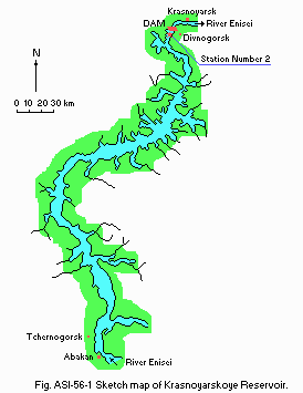
D1 GEOGRAPHICAL (Q)- Bathymetric map: Fig. ASI-56-1.
- Number of outflowing rivers and channels (name): 1 (Enisei R.).
Bathymetric map [m].
D2 CLIMATIC (Q)
- Climatic data at Krasnoyarsk, 1891 1990
| Jan | Feb | Mar | Apr | May | Jun | Jul | Aug | Sep | Oct | Nov | Dec | Ann. | |
|---|---|---|---|---|---|---|---|---|---|---|---|---|---|
| Mean temp. [deg C] | -17.2 | -16.1 | -7.4 | 2.8 | 8.4 | 16.1 | 17.9 | 14.7 | 8.7 | 0.8 | -6.8 | -14.4 | 0.5 |
| Precipitation [mm] | 14 | 11 | 12 | 24 | 44 | 60 | 81 | 75 | 47 | 38 | 29 | 19 | 455 |
- Number of hours of bright sunshine: 1,833 hr yr-1.
- Solar radiation: 11.0 MJ m-2 day 1.
- Water temperature [deg C]
| Station 2 (water depth 100 m), 1983 1987 | ||||||||||||
| Depth [m] | Jan | Feb | Mar | Apr | May | Jun | Jul | Aug | Sep | Oct | Nov | Dec |
|---|---|---|---|---|---|---|---|---|---|---|---|---|
| S*1 | - | - | - | - | 3.0 | 7.1 | 18.9 | 19.3 | 15.9 | 11.8 | - | - |
| 2 | - | - | - | - | 3.0 | 6.6 | 18.1 | 19.2 | 15.8 | 11.8 | - | - |
| 5 | - | - | - | - | 3.0 | 6.4 | 17.3 | 18.8 | 15.8 | 11.8 | - | - |
| 10 | - | - | - | - | 3.0 | 4.2 | 16.6 | 17.8 | 15.8 | 11.8 | - | - |
| 20 | - | - | - | - | 3.0 | 4.0 | 10.6 | 14.8 | 15.5 | 11.8 | - | - |
| 30 | - | - | - | - | 3.0 | 3.9 | 8.2 | 9.8 | 13.4 | 10.8 | - | - |
| 50 | - | - | - | - | 2.9 | 3.9 | 5.0 | 6.0 | 5.3 | 6.9 | - | - |
| N*2 | - | - | - | - | 2.9 | 3.9 | 4.2 | 4.5 | 4.6 | 4.3 | - | - |
- Freezing period (Station 2, 1970 1987): From 8 December to 8 May.
- Mixing type: Dimictic.
- Notes on water mixing and thermocline formation
This deep reservoir is characterized by the alternation of summer and winter stagnation separated by autumn and spring homothermal periods. The period of spring heating begins under ice cover in the first ten days of April when the positive thermal balance sets in. The stability of inverse stagnation is disturbed and vernal circulation begins. This period ends when water in the reservoir reaches the temperature of maximum density for the whole depth in the second ten days of May at the head of the reservoir and in the first ten days of June near the dam. The homothermal conditions are kept up at the head of the reservoir till the water temperature rises to 12 15 deg C. The summer stagnation begins at the time when the mean water level is reached. General cooling of water mass begins in September. The autumn homothermal condition begins at the head of the reservoir at the temperature of 10 12 deg C, while this event is observed only in the last ten days of November near the dam at the temperature of 4.5 5.5 deg C (Q).
E. LAKE WATER QUALITY (Q)
E1 TRANSPARENCY [m]| Station 2, 1983 1987 | ||||||||||||
| Depth [m] | Jan | Feb | Mar | Apr | May | Jun | Jul | Aug | Sep | Oct | Nov | Dec |
|---|---|---|---|---|---|---|---|---|---|---|---|---|
| Mean | - | - | - | - | 4.2 | 3.3 | 1.7 | 2.9 | 3.7 | 3.8 | 3.6 | - |
| Min. | - | - | - | - | 3.4 | 1.8 | 1.2 | 1.4 | 2.5 | 2.9 | 2.8 | - |
| Max. | - | - | - | - | 6.0 | 5.6 | 3.1 | 4.0 | 4.8 | 6.0 | 5.6 | - |
| Station 2, 1970 1979 | ||||
| Depth [m] | Mar-May | Jun-Aug | Sep-Nov | Dec-Feb |
|---|---|---|---|---|
| 0.1 | 7.60-8.05 | 7.40-8.40 | 7.20-8.05 | 7.50-8.05 |
| 100 | 7.60-7.85 | 7.45-8.05 | 7.20-8.10 | 7.45-8.05 |
| Station 2, 1970 1979 | ||||
| Depth [m] | Mar-May | Jun-Aug | Sep-Nov | Dec-Feb |
|---|---|---|---|---|
| 0.1 | 11.60-12.32 | 7.44-12.45 | 7.84-9.91 | 10.66-14.20 |
| 100 | 10.90-12.23 | 7.93-12.77 | 7.70-10.44 | 10.04-13.07 |
- Determined by K2Cr2O7 method.
| Station 2, 1970 1979 | ||||
| Depth [m] | Mar-May | Jun-Aug | Sep-Nov | Dec-Feb |
|---|---|---|---|---|
| 0.1 | 5.9-10.0 | 3.2-17.2 | 4.7-14.4 | 4.8-11.6 |
| 100 | 3.8-13.2 | 2.5-14.2 | 3.5-12.3 | 3.8-10.1 |
- NO3-N [mg l-1]
| Station 2, 1970 1979 | ||||
| Depth [m] | Mar-May | Jun-Aug | Sep-Nov | Dec-Feb |
|---|---|---|---|---|
| 0.1 | 0.04-0.60 | 0.02-0.80 | 0.01-0.55 | 0.02-0.75 |
| 100 | 0.04-0.075 | 0.01-1.00 | 0.01-1.00 | 0.04-0.75 |
- NH4-N [mg l-1]
| Station 2, 1970 1979 | ||||
| Depth [m] | Mar-May | Jun-Aug | Sep-Nov | Dec-Feb |
|---|---|---|---|---|
| 0.1 | 0.05-0.25 | 0.00-0.75 | 0.02-0.22 | 0.00-0.22 |
| 100 | 0.00-0.19 | 0.00-0.47 | 0.00-0.17 | 0.03-0.12 |
- NO2-N [micro l-1]
| Station 2, 1970 1979 | ||||
| Depth [m] | Mar-May | Jun-Aug | Sep-Nov | Dec-Feb |
|---|---|---|---|---|
| 0.1 | 0.0-41.0 | 0.0-27.0 | 0.0-22.0 | 0.0-25.0 |
| 100 | 2.0-32.0 | 0.0-25.0 | 0.0-72.0 | 1.0-27.0 |
- PO4-P [micro 1]
| Station 2, 1970 1979 | ||||
| Depth [m] | Mar-May | Jun-Aug | Sep-Nov | Dec-Feb |
|---|---|---|---|---|
| 0.1 | 0.0-9.0 | 0.0-23.0 | 0.0-3.0 | 0.0-7.0 |
| 100 | 0.0-67.0 | 0.0-45.0 | 0.0-16.0 | 1.0-7.0 |
F. BIOLOGICAL FEATURES
F1 FLORA (2, 3)- Phytoplankton
Melosira granulata, Microcystis sp., Aphanizomenon flos-aquae, Anabaena sp., Asterionella formosa, Merismopedia sp., Cyclotella sp., Fragilaria crotonensis, Stephanodiscus hantzschii.
The quantitative and qualitative peaks of phytoplankton development are observed in late July early August. There are 188 species and forms of phytoplankton in Krasnoyarskoye Reservoir: Chlorophyta 75, Cyanophyta 21, Bacillariophyta 73, Chrysophyta 6, Euglenophyta 4, Xanthophyta 5, Pyrrophyta 4. Two species are spread all over the reservoir water surface (Cyclotella comta and Ankistrodesmus pseudomirabilis); Synedra acus and Asterionella formosa are distributed mainly in channel part; Anabaena flos-aquae and Closterium acerosum are observed mainly in coastal parts and in bays (dominant species).
- Zooplankton
Bosmina longirostris, Daphnia longispina, Eudiaptomus graciloides, Ceriodaphnia sp.
There are 40 species of zooplankton (including Cladocera 21, Copepoda 11 and Rotatoria 5).
Bosmina, Chidorus are dominant in the head of the reservoir; Daphnia longispina, Eudiaptomus graciloides, and Diaphanosoma brachyurum in the middle part and Bosmina at the dam site (dominant species). - Benthos
Chironomidae (Lipininiella arenicola, Stictochironomus, Chironomus thummi, C. bathophilus), Limnodrilus hoffmeisteri, Tubifex tubifex, Uncinais uncinata. There are 200 species and forms of benthos. - Fish
Rutilus rutilus lacustris*, Perca fluviatilis*, Esox lucius, Leuciscus leuciscus, Phoxinus phoxinus , Gymnocephalus cernua, Abramis brama (* economically important).
| Mean for the reservoir, 1978 | |||||
| Jun | Jul | Aug | Sep | Mean for Jun Sep | |
|---|---|---|---|---|---|
| Dark respiration | 2.70 | 9.90 | 6.60 | 4.20 | 5.85 |
| Net production | 1.49 | 1.88 | 1.61 | 1.72 | 1.68 |
| Mean for the reservoir, 1979 | |||||
| Jun | Jul | Aug | Sep | Mean for Jun Sep | |
|---|---|---|---|---|---|
| Dark respiration | 4.33 | 7.18 | 6.89 | 4.33 | 5.68 |
| Net production | 0.78 | 3.08 | 1.09 | 2.04 | 1.74 |
- Biomass of phytoplankton (mean for the whole reservoir)[g m-2](3)
| Year | Jun | Jul | Aug | Sep |
|---|---|---|---|---|
| 1978 | 25.3 | 28.7 | 46.7 | 39.8 |
| 1979 | 8.8 | 20.8 | 30.7 | 33.5 |
- Biomass of zooplankton (mean for 1977 1979)[mg m-3]: 133 (2).
- Annual fish catch (mean for 1976 1980): 316 [metric tons]; 1.74 [kg ha-1](4).
- Past trend of annual fish catch [metric tons]
| Year | Fish catch |
|---|---|
| 1976 | 314.5 |
| 1977 | 292.7 |
| 1978 | 246.7 |
| 1979 | 386.0 |
| 1980 | 341.2 |
G. SOCIO-ECONOMIC CONDITIONS (Q)
G1 LAND USE IN THE CATCHMENT AREA| Area [km2] | [%] | |
|---|---|---|
| Natural landscape | ||
| - Woody vegetation | 191,900 | 66 |
| - Swamp | 2,600 | 1 |
| - Steppe | 80,030 | 28 |
| - Lakes | 3,200 | 1 |
| Agricultural land | ||
| - Crop fields* | 11,270 | 4 |
| Total | 289,000 | 100 |
- Levels of fertilizer application on crop fields: Moderate.
| Population | Population density [km 2] | Major cities | |
|---|---|---|---|
| Urban | 600,000 | - | Abakan, Minusinsk, Tchernogorsk |
| Rural | 3,000,000 | - | |
| Total | 3,600,000 | 12 |
H. LAKE UTILIZATION
H1 LAKE UTILIZATION- Source of water, irrigation, navigation (263,800 persons in 1983) and transportation (856,300 tons in 1983), sightseeing and tourism, recreation (accommodation capacity of 3,000 persons in facilities for long-term stay; swimming, sport-fishing, yachting), fisheries, electric power generation and timber rafting (Q, 4).
| Use rate [1.0E+6 m3 yr-1] | |
|---|---|
| Domestic | 38 |
| Irrigation | 0.4 |
| Industrial | 27 |
| Power plant | 86,764 |
| Special compensation flow | |
| - Transport | 39,282 |
| - Sanitary | 56,720 |
I. DETERIORATION OF LAKE ENVIRONMENTS AND HAZARDS
I1 ENHANCED SILTATION- Extent of damage: Not serious.
- Present status: Detected but not serious.
- Main contaminants, their concentrations and sources
| Name of contaminant | Range of concentrations in water [mg l-1] | Main sources | |
|---|---|---|---|
| 1987 | 1988 | ||
| BOD | 0.60-2.80 | 1.090-3.10 | |
| Phenol | 0.00-0.004 | 0.000-0.003 | Submerged trees |
| Oil products | 0.00-0.64 | 0.00-0.90 | Navigation, hydrolyzing plant, filling mill |
| NH4 | 0.02-0.16 | 0.05-0.27 | Mining |
| Fe | 0.01-0.18 | 0.01-0.20 | |
| Cu | 0.001-0.016 | 0.001-0.055 | |
- Environmental quality standards for contaminants in lake water
| Name of contaminant | Quality standard [mg l-1] |
|---|---|
| BOD | 3.0 |
| Phenol | 0.001 |
| Oil products | 0.05 |
| NH4 | 0.39 |
| Fe | 0.50 |
| Cu | 0.001 |
J. WASTEWATER TREATMENTS
J1 GENERATION OF POLLUTANTS IN THE CATCHMENT AREA- (c) Limited pollution with wastewater treatment.
| [%] | |
|---|---|
| Non-point sources (natural sources and dispersed settlements) | 10 |
| Point sources | |
| - Municipal | 10 |
| - Industrial (including navigation) 80 | |
| Total | 100 |
K. IMPROVEMENT WORKS IN THE LAKE
-
The following measures are being taken by the Administration of Exploitation of Krasnoyarskoye Reservoir for the control of erosion and water pollution.
- Preventing gully formation by constructing small lakes in their drainage
basins, stopping ploughing on the borders of ravines, and planting fast- growing trees. - Reinforcing shorelines by building stone embankments, of which the total
extension is about 2,500 m in the first turn of construction. - Removal of floating and submerged trees in the reservoir.
- The construction of sewage treatment plants for the complete purification of
wastewater from Abakan industrial area.
L. DEVELOPMENT PLANS (4)
- Shallow zones less than 2 m in depth (total area about 80 km2) are going to be filled for agricultural development.
M. LEGISLATIVE AND INSTITUTIONAL MEASURES FOR UPGRADING LAKE ENVIRONMENTS
M2 INSTITUTIONAL MEASURES- Divnogorsk Hydrometeorological Observatory (1967), responsible for monitoring and control
- Administration of Exploitation of Krasnoyarskoye Reservoir (1980)
- Krasnoyarsk State University, Krasnoyarsk
- "Hydroproject"
- State Hydrological Institute, St. Petersburg
N. SOURCES OF DATA
- Questionnaire filled by the Centre for International Projects (CIP), Russia.
- Babkin, V. I., Vuglinsky, V. S., Gronskaya, T. P. & Litova, T. E. (1990) Water inflow to the reservoirs of the largest GES of the USSR. Proceedings of the 5th All-Union Hydrological Congress, 8: 137 142.
- Biological Processes and Self-purification of the Krasnoyarskoye Reservoir (1980) IGU, Krasnoyarsk. 199 pp.
- Comprehensive Investigation of Ecosystems of the Enisei River Basin (1985) KGU, Krasnoyarsk. 180 pp.
- Siberia Reservoirs; Angara-Enisei Basin. Reference Book (1987). 280 pp.
* All printed in Russian.
