
LAKE BALKHASH
A view on the lake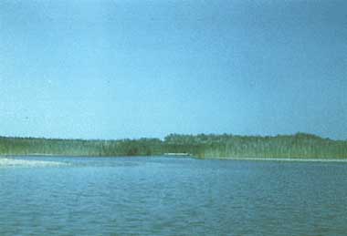
Photo: V.G.Drabkova
A. LOCATION
- Kazakhstan.
- 44:45-46:44N, 73:21-79:30E; 341.4 m above sea level.
B. DESCRIPTION
-
The closed Lake Balkhash is situated in a land depression of tectonic origin. The orography of its drainage basin is very complex: there are high mountain systems, low mountains, plains, and sands partly bordering the lake.
The Balkhash depression is under the influence of arid continental climate with annual precipitation less than 150 200 mm. There is semi-dessert vegetation along the lake shore.
T>he area and water volume of the lake vary considerably in due course depending on the large amplitude of long-term and secular fluctuations of its water level. For example during our century its water surface has changed from 15,730 km2 (1946) to 23,464 km2 (1910) and its water volume from 82.70 km3 to 163.9 km3.
The difference between the eastern and the western parts of the lake basin is essential. There are 58% of the total water surface and 46% of the lake water volume in the western part. The mean depth of the eastern part is 1.7 times more than those of the western part. The western part of the lake has fresh or slightly salty water (0.5% 1.5%) depending on the secular fluctuation of its water level, while the eastern part is characterized by rather high concentration of dissolved solids (up to 7%). The main reasons for such a difference are the inflow of a huge river to the western part and the retarded exchange of water between the two parts.
Balkhash is very important for its utilization. The water resources of the lake and its tributary rivers are used for irrigation, municipal and industrial water supply (including the supply for the Balkhash Copper Melting Plant). The fish catch in the lake is also very important for the Kazakhstan.
During the latest years, the problem of Balkhash Lake became more explicit because of the start of the filling of Kaptchagayskoye Reservoir (with a volume of 29 km3) on the River Ili. The filling of the first 14 km has resulted in negative consequences on the water level, water-salt balance and ecology of the lake. The main problem is how to harmonize natural-ecological conditions of this lake with the need of a reservoir for irrigation, water supply and hydropower production (Q).
C. PHYSICAL DIMENSIONS
| Surface area [km2] | 18,200 |
| Volume [km3] | 106 |
| Maximum depth [m] | 25.6 |
| Mean depth [m] | 5.8 |
| Water level | Unregulated |
| Normal range of annual water level fluctuation [m] | 1.6 |
| Length of shoreline [km] | 2,385 |
| Residence time [yr] | 6.8 |
| Catchment area [km2] | 413,000* |
D. PHYSIOGRAPHIC FEATURES
D1 GEOGRAPHICAL- Bathymetric map: Fig. ASI-54-1.
- Number of main islands (name and area)
Bazaral, Ortaaral, Ayakaral, Ununaral, Tasaral (total area 518 km2). - Number of outflowing rivers and channels: None.
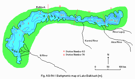
Bathymetric map [m].
D2 CLIMATIC
- Climatic data at Balkhash Hydrometeorological Observatory, 1986 1990
| Jan | Feb | Mar | Apr | May | Jun | Jul | Aug | Sep | Oct | Nov | Dec | Ann. | |
|---|---|---|---|---|---|---|---|---|---|---|---|---|---|
| Mean temp. [deg C] | -10.7 | -12.7 | 4.1 | 7.2 | 16.7 | 22.6 | 25.3 | 23.0 | 16.6 | 7.2 | -1.2 | -5.5 | 6.9 |
| Precipitation [mm] | 16.4 | 12.4 | 14.3 | 16.5 | 21.6 | 18.1 | 20.0 | 15.0 | 6.7 | 14.9 | 13.3 | 17.8 | 187 |
- Number of hours of bright sunshine: 3,130 hr yr-1.
- Solar radiation: 15.9 MJ m-2 day 1.
- Water temperature [deg C]
| Station 63, 1985 1987 | ||||||||||||
| Depth [m] | Jan | Feb | Mar | Apr | May | Jun | Jul | Aug | Sep | Oct | Nov | Dec |
|---|---|---|---|---|---|---|---|---|---|---|---|---|
| S*1 | - | -0.2 | 0.2 | - | 13.9 | 19.0 | 23.4 | 23.2 | 17.2 | 11.4 | - | - |
| 2 | - | 0.4 | - | - | 13.4 | 17.7 | 22.7 | 23.2 | 17.2 | - | - | - |
| 5 | - | 0.7 | - | - | 12.0 | 17.2 | 22.4 | 23.0 | - | - | - | - |
| 10 | - | 1.0 | - | - | 10.8 | 16.7 | 21.7 | 22.8 | - | - | - | - |
| 15 | - | 1.6 | - | - | 9.3 | 16.3 | 19.9 | 22.8 | - | - | - | - |
| N*2 | - | 1.7 | 1.9 | - | 8.9 | 13.7 | 14.6 | 19.7 | 17.1 | 11.5 | - | - |
| Station 74, 1985 1987 | ||||||||||||
| S*1 | - | 0.0 | 0.8 | 6.7 | 13.3 | 20.5 | 24.7 | 22.7 | 16.6 | 7.8 | 2.0 | - |
| N*2 | - | 0.3 | 2.2 | 6.5 | 13.1 | 19.6 | 24.1 | 22.6 | 16.5 | 7.4 | 2.0 | - |
- Freezing period: From late November to early April, 141 days.
- Mixing type: Polymictic (western part), dimictic (eastern part).
- Notes on water mixing and thermocline formation
The vertical thermal stratification develops only incompletely, owing to the wind-driven convection of the lake water masses. The spring change from winter to summer stagnation is observed in the second ten days of May. The autumn homothermal condition develops in the first ten days of October. The winter stagnation lasts from early October to middle May.
E. LAKE WATER QUALITY
E1 TRANSPARENCY [m]| Station 63, 1981 1983 | ||||||||||||
| Depth | Jan | Feb | Mar | Apr | May | Jun | Jul | Aug | Sep | Oct | Nov | Dec |
|---|---|---|---|---|---|---|---|---|---|---|---|---|
| - | 4.2 | 6.0 | - | 7.9 | - | 12.0 | - | - | 3.0 | - | - | |
| Station 74, 1981-1983 | ||||||||||||
| - | 1.3 | - | 0.4 | 0.4 | 0.6 | 0.9 | 0.7 | 0.6 | 0.4 | 0.5 | - | |
| Station 63, 1981 1983 | ||||||||||||
| Depth [m] | Jan | Feb | Mar | Apr | May | Jun | Jul | Aug | Sep | Oct | Nov | Dec |
|---|---|---|---|---|---|---|---|---|---|---|---|---|
| S*1 | - | 9.0 | 8.8 | - | 9.0 | - | 9.0 | - | - | 9.0 | - | - |
| N*2 | - | 9.0 | 8.8 | - | 9.0 | - | 9.0 | - | - | 9.0 | - | - |
| Station 74, 1981 1983 | ||||||||||||
| S | - | 8.6 | 8.6 | 8.6 | 8.6 | 8.6 | 8.5 | 8.6 | - | 8.6 | 8.6 | - |
| N | - | 8.6 | 8.6 | 8.6 | 8.6 | 8.6 | 8.5 | 8.6 | - | 8.6 | 8.6 | - |
| Station 74, 1983 | ||||||||||||
| Depth [m] | Jan | Feb | Mar | Apr | May | Jun | Jul | Aug | Sep | Oct | Nov | Dec |
|---|---|---|---|---|---|---|---|---|---|---|---|---|
| 0.1 | - | 112 | - | - | 47.6 | 26.0 | 58.4 | 36.8 | - | 24.8 | 32 | - |
| Station 63, 1983 | ||||||||||||
| Depth [m] | Jan | Feb | Mar | Apr | May | Jun | Jul | Aug | Sep | Oct | Nov | Dec |
|---|---|---|---|---|---|---|---|---|---|---|---|---|
| 0.1 | - | 13.4 | - | 14.5 | 9.4 | - | 10.1 | - | - | 9.9 | - | - |
| N*1 | - | 11.5 | - | 9.4 | 10.6 | - | 9.9 | - | - | 9.9 | - | - |
| Station 74, 1983 | ||||||||||||
| S*2 | - | 14.2 | 10.9 | 12.0 | 9.7 | - | 8.6 | 7.7 | 8.8 | 11.0 | 13.0 | - |
| N | - | 14.4 | 13.5 | 11.0 | 10.0 | - | 7.9 | 7.6 | 8.8 | 11.7 | 13.0 | - |
- Total-N [mg l-1]
| Station 63, 1983 | ||||||||||||
| Depth [m] | Jan | Feb | Mar | Apr | May | Jun | Jul | Aug | Sep | Oct | Nov | Dec |
|---|---|---|---|---|---|---|---|---|---|---|---|---|
| 0.1 | - | 0.01 | 0.0 | - | 0.0 | - | 0.0 | - | - | 0.0 | - | - |
| N* | - | 0.0 | 0.01 | - | 0.0 | - | 0.0 | - | - | 0.0 | - | - |
| Station 74, 1983 | ||||||||||||
| 0.1 | - | 0.0 | 0.0 | - | 0.11 | - | 0.0 | 0.15 | 0.0 | 0.0 | 0.0 | - |
| N | - | 0.0 | 0.01 | - | 0.01 | - | 0.0 | 0.13 | 0.0 | 0.02 | 0.0 | 0.0 |
- Total-P [micro l-1]
| Station 63, 1983 | ||||||||||||
| Depth [m] | Jan | Feb | Mar | Apr | May | Jun | Jul | Aug | Sep | Oct | Nov | Dec |
|---|---|---|---|---|---|---|---|---|---|---|---|---|
| 0.1 | - | 16 | - | - | 24 | - | 11 | - | - | 61 | - | - |
| N* | - | 18 | - | - | 15 | - | 13 | - | - | 65 | - | - |
| Station 74, 1983 | ||||||||||||
| 0.1 | - | 20 | - | - | 36 | - | 36 | - | - | 57 | - | - |
| N | - | 13 | - | - | 26 | - | 67 | - | - | 51 | - | - |
| Station 63, 1983 | ||||||||||||
| Depth [m] | Jan | Feb | Mar | Apr | May | Jun | Jul | Aug | Sep | Oct | Nov | Dec |
|---|---|---|---|---|---|---|---|---|---|---|---|---|
| 0.1 | - | 1,184 | - | - | 1,159 | - | 1,179 | - | - | 1,184 | - | - |
| N* | - | 1,184 | - | - | 1,145 | - | 1,187 | - | - | 1,181 | - | - |
| Station 74, 1983 | ||||||||||||
| 0.1 | - | 492.8 | - | - | 391.0 | - | 407.4 | - | - | 404.2 | - | - |
| N | - | 489.3 | - | - | 391.0 | - | 407.3 | - | - | 390.0 | - | - |
| * Near bottom. | ||||||||||||
F. BIOLOGICAL FEATURES
F1 FLORA- Emerged macrophytes (1)
Phragmites australis, Typha angustata, Scirpus littoralis, S. lacustris, S. kasachstanicus . - Submerged macrophytes (1)
Myriophyllum spicatum, M. verticillatum, Potamogeton lucens , P. perfoliatus, P. crispus, P. pectinatus, P. macrocarpus, Utricularia vulgaris, Ceratophyllum demersum, Najas marina , N. minor. - Phytoplankton (dominant species)(2)
Region I: Melosira granulata, Microcystis flos-aquae, Lyngbya.
Region II: M. granulata, Ceratium, Conscinodiscus, Microcystis.
Region III: Peridinium latum, Gomphosphaeria lacustris, Nodularia spumigena, Microcystis, Campylodiscus clypeus.
Region IV: Nodularia, Glenodinium borgei, Campylodiscus clypeus.
Region V: Chaetoceros sp.
- Zooplankton
Codonella cratera, Synchaeta sp., Filinia longiseta, F. longiseta var. limnetica, Polyarthra platyptera, Pompholyx sulcata, Keratella quadrata, K. quadrata var. valga, K. cochlearis, K. cochlearis var. tecta, Anapus testudo, Hexarthra oxyure, Arctodiaptomus salinus, Mesocyclops crassus, M. leuckarti, Daphnia cristata, Diaphanosoma brachyurum, Chydorus sphaericus, Leptodora kindtii. - Benthos (dominant species)
Chironomidae (Chironomus salinarius, C. plumosus, Parachironomus, Prochironomus, Endochironomus nymphoides, Stictochironomus, Cryptochironomus, Protenthes, Tanypus, Harnischia), Oligochaeta. - Fish
Perca schrenki*+, Schizothorax argentatus*+, S. pseudoksaiensis*, Acipenser nudiventis, Leuciscus leuciscus natio, Phoxinus poljakowi, Barbus branchicephalus, Abramis brama orientalis*, Cyprinus carpio*, Carassius auratus gibelio, Nemachilus strauchi, N. labiatus*+, Lucioperca lucioperca, Silurus glanis (* economically important; + endemic species).
- 1985
- Biomass of phytoplankton: 1.127 [g l-1].
- Biomass of zooplankton: 1.87 [g l-1].
- Biomass of benthos [g m-2]
For the western part: 3.07.
For the eastern part: 3.75.
- Annual fish catch [metric tons]
1979: 13.1.
G. SOCIO-ECONOMIC CONDITIONS
G1 LAND USE IN THE CATCHMENT AREA (4, 5)| 1981 | ||
| Area [km2] | [%] | |
|---|---|---|
| Natural landscape | ||
| - Woody vegetation | 35,000 | 8.5 |
| - Steppe & Semi-desert | 63,000 | 15.4 |
| - Lake and reservoir | 7,600 | 1.8 |
| Agricultural land | ||
| - Pasture | 184,000 | 44.4 |
| - Irrigated crop-field | 55,000 | 13.3 |
| - Hay-making land | 6,000 | 1.3 |
| Others | 450 | 0.2 |
| In the territory of China | 61,950 | 15.0 |
| Total | 413,000 | 100 |
- Main species in forest and scrub vegetation (2)
Picea schrenkiana, Fraxinus sogdiana, Acer semenovii, Lonicera hispida, Berberis heteropoda, Euonimus semenovii, Hippophae rhamnoides, Tamarix ramosissima, Haloxyon ammodendon. - Main species in herbaceous vegetation (2)
Anabasis salsa, Nanophyton erinaceum, Halocnemum strobilaceum, Artemisia terrae alba, Salsola arbuscula, reeds. - Main kinds of crops (3)
Fodder crop (44%), cereal crop (25%), technical crops (mainly sugar beet and tobacco) (9%), orchard, vineyard, vegetable and melon field. - Levels of fertilizer application on crop fields: Moderate.
- 1981
- Number of domestic animals in the catchment area
Cattle 600,000, sheep 6,000,000, swine 240,000.
| 1981 | |||
| Population [x1.0E+6] | Population density [km 2] | Major cities | |
|---|---|---|---|
| Rural | 1.0 | - | Taldy-Kurgan |
| Urban | 1.5 | - | Alma-Ata, Balkhash |
| Total | 2.5 | 7.7 | |
H. LAKE UTILIZATION
H1 LAKE UTILIZATION- Source of water, fishery, navigation and transportation.
I. DETERIORATION OF LAKE ENVIRONMENTS AND HAZARDS
I2 TOXIC CONTAMINATION- Present status: Serious with respect to Cu.
- Main contaminants, their concentrations and sources (20)
| Name of contaminant | Range of concentrations in water [mg l-1] | Main sources | ||
|---|---|---|---|---|
| 1987 | 1988 | 1989 | ||
| Oil products | 0.000-0.780 | 0.000-0.320 | 0.000-0.670 | Navigation |
| Phenol | 0.000-0.004 | 0.000-0.000 | 0.000-0.009 | Copper melting plant |
| Cu | 0.012-0.058 | 0.017-0.051 | 0.003-0.048 | Copper melting plant |
- Environmental quality standards for contaminants in lake water
| Name of contaminant | Quality standard [mg l-1] |
|---|---|
| Oil products | 0.05 |
| Phenol | 0.001 |
| Cu | 0.001 |
J. WASTEWATER TREATMENTS
J1 GENERATION OF POLLUTANTS IN THE CATCHMENT AREA- (e) Severe pollution with no wastewater treatment (for Cu pollution only).
- Supplementary notes
The severe Cu pollution is caused by the wastewater from a Copper melting plant.
| [%] | |
|---|---|
| Non-point sources | 5 |
| Point source Industrial | 95 |
| Total | 100 |
K. IMPROVEMENT WORKS IN THE LAKE
- Stopping the further filling of Kaptchagayskoye Reservoir, purification of wastewater of the copper melting plant, reducing irretrievable losses of water resources used for irrigation, etc. are suggested.
M. LEGISLATIVE AND INSTITUTIONAL MEASURES FOR UPGRADING LAKE ENVIRONMENTS
M3 RESEARCH INSTITUTES ENGAGED IN THE LAKE ENVIRONMENT STUDIES- Balkhash Hydrometeorological Observatory, Balkhash
- Kazakh Hydrometeorological Institute, Alma-Ata
- The Institute of Limnology, St. Petersburg
- The State Hydrological Institute, St. Petersburg
- Kazakh Institute of Fishery, Alma-Ata and Balkhash
N. SOURCES OF DATA
- Influence of Industrial Activity on Biological Resources of Reservoirs in Kazakhstan. (1989) "Nauka", Alma-Ata. 100 pp.
- Abrosov, V. N. (1973) Balkhash Lake. "Nauka", Leningrad. 180 pp.
- Natural Resources of Big Lakes in the USSR and Their Possible Changes (1984) "Nauka", Leningrad. 286 pp.
- Hydrological and Water-industrial Aspects of Ili-Balkhash Problem (1989) "Hydrometeoizdat", Leningrad. 310 pp.
- Geographic Atlas of the USSR (1981) Moscow.
* All printed in Russian.
