
LAKE HUBSUGUL
A view on the lakeshore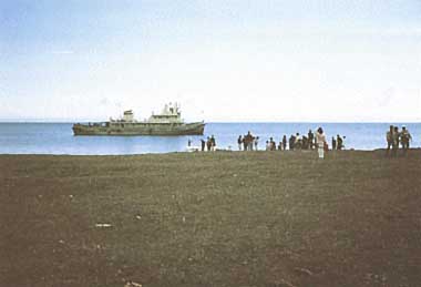
Photo: P.Nyamjav
A. LOCATION
- Hubsugul Aimag, Mongolia.
- 50:27-51:37N, 100:51-101:47E; 1,645 m above sea level.
B. DESCRIPTION
-
Lake Hubsugul is the largest freshwater lake in Central Asia. The landscape complex around the lake is unique and inimitable in its beauty. The lake basin consists largely of highlands, where underground permafrost layers, sometimes as deep as 100-200 m, are widespread.
The climate is severely continental with 300-430 mm of mean annual precipitation. Between the lake shore and the top of high mountains reaching 3,491 m in altitude, there is a series of alternating vegetation zones from steppe, through forest-steppe, forest and forest-tundra, to alpine tundra zone. Forests of larch, cedar, pine and birch predominate on permafrost, together with tundra. The lake basin supports 60 species of mammals including 32 game animals and 800 species of plants of which more than 50% are grasses and herbs.
The lake has three tributaries, while a single river, the Egyn-gol flows out toward Lake Baikal. There are petroleum fields in Hatafal and Hanh on the north and the south side of the lake. More than 30 phosphorite beds have also been exploited.
It is of prime importance for this lake as a natural treasure how to maintain its crystal-clean water against the impact from industrial developments. The exploitation of phosphorite beds may disrupt surrounding environments, Lake Hubsugul, and eventually Lake Baikal via the Egyn. Local authorities are making efforts to cope with the problem, but the processes and extent of industrial influence on the environment still remain unknown because of the lack of comprehensive ecological research on the complex system of the lake, its surroundings, rivers and springs (Q1).
C. PHYSICAL DIMENSIONS (Q1, 2)
| Surface area [km2] | 2,770 |
| Volume [km3] | 381 |
| Maximum depth [m] | 267 |
| Mean depth [m] | 138 |
| Water level | Unregulated |
| Normal range of annual water level fluctuation [m] | 0.5-2.0 |
| Length of shoreline [km] | 414 |
| Catchment area [km2] | 4,940 |
D. PHYSIOGRAPHIC FEATURES (Q1)
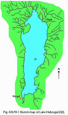
D1 GEOGRAPHICAL- Bathymetric map: Fig. ASI-51-01.
- Names of main islands: Modon Khui and Khadan Khui.
- Number of outflowing rivers and channels (name): 1 (Egyn-gol).
- Climatic data at Hatgal, 1980-1989
| Jan | Feb | Mar | Apr | May | Jun | Jul | Aug | Sep | Oct | Nov | Dec | Ann. | |
|---|---|---|---|---|---|---|---|---|---|---|---|---|---|
| Mean temp. [deg C]*1 | -22.7 | -21.2 | -13.1 | -2.5 | 5.5 | 9.2 | 11.4 | 10.4 | 4.6 | -3.8 | -14.2 | -20.4 | -4.8 |
| Precipitation [mm]*2 | 0.8 | 0.3 | 2 | 8 | 17 | 77 | 90 | 71 | 31 | 11 | 10 | 0.4 | 319 |
- Number of hours of bright sunshine: 2,773 hr yr-1.
Bathymetric map [m](Q1).
- Water temperature [deg C]
| Depth [m] | Jan | Feb | Mar | Apr | May | Jun | Jul | Aug | Sep | Oct | Nov | Dec |
|---|---|---|---|---|---|---|---|---|---|---|---|---|
| 0.5 | - | - | - | - | 5.1 | 9.9 | 13.4 | 13.6 | 9.5 | 3.8 | - | - |
- Freezing period: ca. 15 June-25 October.
E. LAKE WATER QUALITY (Q1)
E1 TRANSPARENCY [m]| Depth [m] | Jan | Feb | Mar | Apr | May | Jun | Jul | Aug | Sep | Oct | Nov | Dec |
|---|---|---|---|---|---|---|---|---|---|---|---|---|
| 30 | 30 | - | - | - | - | 19 | 13 | 24 | - | 30 | 30 |
| Depth [m] | Jan | Feb | Mar | Apr | May | Jun | Jul | Aug | Sep | Oct | Nov | Dec |
|---|---|---|---|---|---|---|---|---|---|---|---|---|
| Station 1, Hatgal, 1986-1990 | ||||||||||||
| 0.5 | 7.9 | 7.6 | 7.8 | 7.4 | 6.9 | 7.9 | 7.9 | 7.9 | 8.0 | 7.8 | 8.0 | 7.6 |
| Station 2, Hanh, 1986-1990 | ||||||||||||
| 0.5 | 7.9 | 7.9 | 8.0 | 7.5 | 7.6 | 8.2 | 7.4 | 7.9 | 7.7 | 7.5 | 8.1 | 7.8 |
| Hanh, 1986 | ||||||||||||
| Depth [m] | Jan | Feb | Mar | Apr | May | Jun | Jul | Aug | Sep | Oct | Nov | Dec |
|---|---|---|---|---|---|---|---|---|---|---|---|---|
| 0.5 | 7.7 | 7.7 | 10.3 | 10.9 | 8.4 | 7.0 | 9.0 | 8.3 | 9.4 | - | - | - |
| Determined by KMnO4 method. | ||||||||||||
| Depth [m] | Jan | Feb | Mar | Apr | May | Jun | Jul | Aug | Sep | Oct | Nov | Dec |
|---|---|---|---|---|---|---|---|---|---|---|---|---|
| Station 1, 1986-1990 | ||||||||||||
| 0.5 | 1.1 | 2.7 | 2.3 | 2.1 | 0.9 | 2.1 | 1.8 | 3.1 | 1.9 | 2.7 | 2.4 | 1.5 |
| Station 2, 1986-1990 | ||||||||||||
| 0.5 | 1.4 | 2.0 | 3.2 | 1.8 | 1.5 | 3.7 | 2.2 | 1.5 | 3.3 | 1.4 | 2.2 | 2.6 |
- The content of chlorophyll a of the lake water is very low, being 0.35 micro l-1 in average for the layer of 0-100 m.
- NO3-N [mg l-1]
| Depth [m] | Jan | Feb | Mar | Apr | May | Jun | Jul | Aug | Sep | Oct | Nov | Dec |
|---|---|---|---|---|---|---|---|---|---|---|---|---|
| Station 1, 1986-1990 | ||||||||||||
| 0.5 | 0.05 | 0.19 | 0.17 | 0.32 | 0.12 | 0.19 | 0.20 | 0.22 | 0.08 | 0.11 | 0.06 | 0.02 |
| Station 2, 1986-1990 | ||||||||||||
| 0.5 | 0.18 | 0.20 | 0.27 | 0.10 | 0.11 | 0.19 | 0.67 | 0.10 | 0.10 | 0.21 | 0.05 | 0.02 |
- NH4-N [mg l-1]
| Depth [m] | Jan | Feb | Mar | Apr | May | Jun | Jul | Aug | Sep | Oct | Nov | Dec |
|---|---|---|---|---|---|---|---|---|---|---|---|---|
| Station 1, 1986-1990 | ||||||||||||
| 0.5 | 0.14 | 0.16 | 0.14 | 0.21 | 0.16 | 0.05 | 0.18 | 0.30 | 0.15 | 0.04 | 0.10 | 0.11 |
| Station 2, 1986-1990 | ||||||||||||
| 0.5 | 0.11 | 0.14 | 0.18 | 0.13 | 0.28 | 0.19 | 0.24 | 0.14 | 0.14 | 0.04 | 0.08 | 0.08 |
- Total-P [micro g l-1]
| Depth [m] | Jan | Feb | Mar | Apr | May | Jun | Jul | Aug | Sep | Oct | Nov | Dec |
|---|---|---|---|---|---|---|---|---|---|---|---|---|
| Station 1, 1986-1990 | ||||||||||||
| 0.5 | 46 | 12 | 14 | 4 | 8 | 5 | 7 | 13 | 20 | 15 | 8 | 7 |
| Station 2, 1986-1990 | ||||||||||||
| 0.5 | 14 | 2 | 9 | 9 | 6 | 18 | 18 | 4 | 16 | 11 | 23 | 9 |
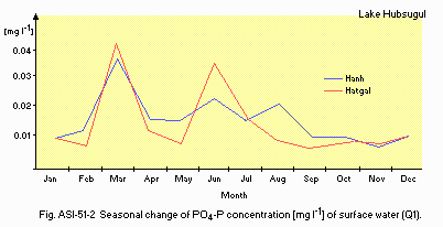
Seasonal change of PO4-P concentration [mg l-1] of surface water (Q1).
E10 PAST TRENDS
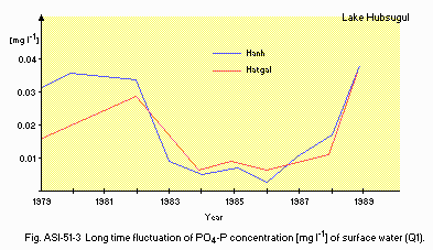
Long time fluctuation of PO4-P concentration [mg l-1] of surface water (Q1).
F. BIOLOGICAL FEATURES
F1 FLORA (6)- There are 55 species of floating aquatic plant, 33 species of submerged macrophyte, 2 species of moss and about 10 species of phytoplankton in the lake.
- Emerged macrophytes: Poaceae, Asteraceae, Cyperaceae (Q2).
- Phytoplankton (Q2)
Cyclotella ocellata, Gymnodinium fuscum, Oocystis sobitaria, O. mongolica, Dictyosphaerium pulchellum, Chroomonas sp., Crucigenia quadrata, Glenodinium sp.
- Zooplankton
Mixodiaptomus incrassatus, Cyclops abyssorum, Daphnia longispina hyalina, Kellicottia longispina, Filinia longiseta, Conochilus unicornis (total 69 species). - Benthos
Hydra, Phabdococcida, Planaridae, Nematoda, Oligochaeta, Ostracoda, Gammaridae (total 170 species). - Fish
Brachymystax lenok, Coregonus autumnalis migratorius, Thymallus arcticus, T. nigrescens, Rutilus lacustris, Lota vulgaris, Lota lota, Perca fluviatilis (total 9 species).
- Phytoplankton (8)
| Whole lake | |||
| No. of samples | No. [1,000 l-1] Mean (range) | Biomass [mg m-3] Mean (range) | |
|---|---|---|---|
| Jun.-Aug. 1972 | 50 | 812 (355-1,650) | 166 (64-301) |
| Mar. 1973 | 21 | 1,399 (99-2,806) | 212 (22-453) |
| Pelagic water, Hanh region (Q1) | |||||
| Date | Biomass [mg m-3] | ||||
|---|---|---|---|---|---|
| Cyclotella ocellata | Dictyosphaerium pulchellum | Total | |||
| 1976 | Jun. 16 | 17 | 61 | 113 | |
| Jul. 8 | 30 | 58 | 135 | ||
| Jul. 20 | 46 | 31 | 179 | ||
| Jul. 29 | 57 | 28 | 140 | ||
| Aug. 9 | 92 | 33 | 172 | ||
| Aug. 20 | 96 | 34 | 204 | ||
| Sep. 18 | 67 | 2 | 95 | ||
| Sep. 25 | 104 | 2 | 140 | ||
| Oct. 21 | 37 | 7 | 81 | ||
| Dec. 22 | 160 | 25 | 226 | ||
| 1977 | Feb. 28 | 36 | 25 | 85 | |
| Mar. 21 | 36 | 57 | 137 | ||
| Mar. 27 | 50 | 73 | 173 | ||
| May. 13 | 22 | 78 | 144 | ||
| Mean | 61 | 37 | 145 | ||
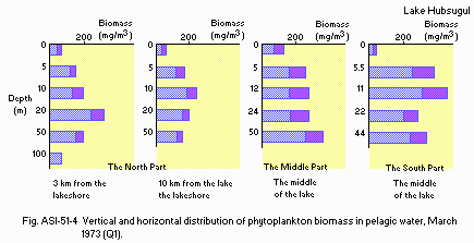
Vertical and horizontal distribution of phytoplankton biomass in pelagic water, March 1973 (Q1).
- Zooplankton (9)
| Whole lake survey | |||||
| Date | No. of samples | Mean No. (range)[1,000 l-1] | |||
|---|---|---|---|---|---|
| Copepoda | Cladocera | Rotatoria | Total | ||
| Jun.-Aug. 1978 | 18 | 9.2 (1.7-21.6) | 0.66 (0.1-2.4) | 0.32 (0.1-0.9) | 10.1 (1.9-22.4) |
| Jul. 1979 | 9 | 8.3 (5.1-10.1) | 0.44 (0.1-0.7) | 0.54 (0.1-1.1) | 9.3 (5.8-11.4) |
| Date | No. of samples | Mean No. (range)[mg m-3] | |||
|---|---|---|---|---|---|
| Copepoda | Cladocera | Rotatoria | Total | ||
| Jun. -Aug. 1978 | 18 | 158.2 (11.4-362.0) | 11.0 (0.3-34.6) | 0.31 (0.1-1.0) | 168.4 (11.8-373.4) |
| Jul. 1979 | 9 | 183.6 (78.0-283.0) | 8.0 (3.0-16.0) | 0.69 (0.1-1.0) | 192.2 (82.0-299.2) |
- Zoobenthos (8)
| Whole lake survey | ||
| Zone (depth) | Mean No. [m-2] | Mean biomass [g m-2] |
|---|---|---|
| Open water | ||
| - Littoral (0-20 m) | 4,304 | 4.8 |
| - Sublittoral (20-50 m) | 4,267 | 5.4 |
| - Upper abyssal (50-90 m) | 1.322 | 0.8 |
| - Lower abyssal (>90 m) | 303 | 0.2 |
| Bays | ||
| - Alagasair | 7,190 | 4.5 |
| - Turugsky | 5,350 | 6.5 |
| - Khankhinsky | 10,862 | 3.8 |
| - Mongorinsky | 5,903 | 10.3 |
| Hanh region | |||
| Date | No. of samples | No. [m-2] | Biomass [g m-2] |
|---|---|---|---|
| Aug. 1971 | 6 | 2,399 | 1.8 |
| Jun. 1972 | 15 | 7,570 | 3.8 |
| Jul. 1976 | 2 | 9.570 | 5.7 |
| Aug. 1976 | 8 | 8,053 | 2.7 |
| Sep. 1976 | 4 | 5,252 | 1.8 |
- Total biomass of the whole lake system (Q)
| Zone | [g m-3] | [g m-2] | [1,000 t/zone] | |
|---|---|---|---|---|
| Littoral & sublittoral (15% of total lake area) | Phytobenthos | - | 0.6-3.5 | |
| Zoobenthos | - | 5.0 | 2,070 | |
| Abyssal (85%) | Zoobenthos | - | 0.5 | 1,173 |
| Whole water column | Bacterioplankton | 0.03 | 3.48 | 9,605 |
| Photic zone (mean depth 16 m) | Phytoplankton | 0.17 | 19.72 | 54,427 |
| Zooplankton | 0.10 | 11.60 | 32,016 |
- Annual fish catch [metric tons]
- 1990: 300.
G. SOCIO-ECONOMIC CONDITIONS
G1 LAND USE IN THE CATCHMENT AREA| Area [km2](Q1) | [%](Q2) | |
|---|---|---|
| Natural landscape | ||
| - Woody vegetation | - | 30-60 |
| - Herbaceous vegetation | - | 20-30 |
| - Swamp | - | 5-10 |
| - Others | - | 5-10 |
| Agricultural land | ||
| - Crop field | (9.2) | |
| - Pasture land | 2.7 | 25-30 |
| Residential area | 6.5 | |
| Total | 4,920 | 100 |
- Types of important forest vegetation (Q1, Q2)
Larix sibirica and Betula platyphylla, with Lonicera altaica, Ledum palustre, Vaccinium vitis-idaea, Calamagrostis obtusata, Aconitum septentrionale, Hylocomium proliferum, etc. - Types of other important vegetation (Q1, Q2)
High mountain lichen-moss tundra (Cladonia alpestris, Cetraria cuculata). - Main kinds of crops: No crop field.
- Numbers of domestic animals in the catchment area (Q2)
Cattle 8,466, sheep 6,650, others 1,434.
| 1990 | |||
| Population | Population density [km-2] | Major cities (population) | |
|---|---|---|---|
| Urban | 5,473 | - | |
| Rural | 1,163 | - | Hatgal |
| Total | 6,636 | 1.3 | |
H. LAKE UTILIZATION
H1 LAKE UTILIZATION (Q1)- Source of water, navigation and transportation (20,000-30,000 tons of cargo per year during 1953-1990; it will be stopped in the second half of 1991), sightseeing and recreation.
- Use rate of domestic water: 1.43 [m3 sec-1].
I. DETERIORATION OF LAKE ENVIRONMENTS AND HAZARDS (Q2)
I1 ENHANCED SILTATION: None. I2 TOXIC CONTAMINATION- Present status: None.
- Extent of damage: None.
J. WASTEWATER TREATMENTS (Q2)
J1 GENERATION OF POLLUTANTS IN THE CATCHMENT AREA-
b) No sources of significant pollution.
M. LEGISLATIVE AND INSTITUTIONAL MEASURES FOR UPGRADING LAKE ENVIRONMENTS (Q1)
M1 NATIONAL AND LOCAL LAWS CONCERNED- The Government had closed the wool-washing factory from July 1988, and also has decided to remove the petroleum reserve to Muren town within 1991.
- Hubsugul Lake Protection Foundation
- The administration for the Hubsugul Lake protection.
- Soviet Union and Mongol joint expeditions for the Hubsugul Lake study.
N. SOURCES OF DATA
- Questionnaire filled by Dr. P. Nyamjav, Head, Surface Water Resource Sector, State Committee for Environmental Control Institute of Water Problems, Ulaanbaatar, Mongolia. (Q1)
- Questionnaire filled by Mr. Ts. Baldorj, Newspaper of the MPR Government (UNEN), Ulaanbaatar, Mongolia. (Q2)
- Tserensodnom, J. (1970) Lakes of Mongolia. Ulaanbaatar.
- Dulmaa, A. (1985) Life in the Lake. Ulaanbaatar.
- Gira, E. (1985) Climatic Reference Book of the MPR. Vol. 1, Solar Energy Cadastre. Ulaanbaatar.
- Erbaev, E. A. & Kojova, 0. M. (1990) The problems of zoobenthos study of the Hubsugul Lake. Natural condition and resources of some regions of the MPR. Theses of the talks and conferences, XVII International Scientific Conference on the Results of the Mongolian and the Soviet Union Complex Expedition Work of the Hubsugul Lake.
- Dulmaa, A. & Tserensambuu, S. (1990) General Estimation of Primary Productivity of the MPR's Lakes. Ulaanbaatar.
- --- & --- (1990) The Hubsugul Lake monitoring. "Problems of Nature and Environmental Protection of the Hubsugul Lake and the Selenge River Basins." Ulaanbaatar.
- Kojova, 0. M. & Zagorencko, G. F. (1976) Winter phytoplankton of the Hubsugul Lake. "Natural Condition and Resources of Prikhubsugul, Proceedings of the USSR and MPR Complex Expedition of the Hubsugul", Issue 3-4. Irkutsk-Ulaanbaatar.
- Kojova, 0. M., Zagorencko, G. E., Pomazkova, G. I., Putyatina, T. N., Erbaev, E. A. & Izmesteva, L. R. (1978) Hydrological regime of the Hubsugul Lake. "Hydrobiological and Ichtiological Studies in the East Siberia." Irkutsk.
- Pomazkova, G. I. & Shyagina, E. V. (1982) Distribution of zooplankton in the Hubsugul Lake in summer, 1978-1979. "Natural Condition and Resources of Prikhubsugul, The Proceedings of the Research Talks, ISU, MSU."
- Tsengel, T. (1990) The principal characteristics of the Hubsugul Lake. "Problems of Nature and Environment Protection of the Hubsugul Lake and the Selenge River Basins, The Proceedings of the Research Conference." Ulaanbaatar.
