
PARAKRAMA SAMUDRA (LAKE PARAKRAMA)
A view of the lakeside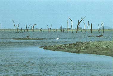
Photo: P.Newrkla
A. LOCATION
- North Central, Sri Lanka.
- 7:55N, 81:00E; 58.5 m above sea level.
B. DESCRIPTION
-
Parakrama Samudra, the Sea of King Parakrama as the name literally means, is a shallow reservoir with a surface area of 22.6 km2. It consists of three separate reservoirs connected only by narrow channels at low water. The northernmost reservoir is the oldest and referred to as Topa wewa (Sinhalese wewa=lake or reservoir). The middle section is Eramudu wewa and the southernmost portion at the highest elevation is Dumbutula wewa. Topa wewa was built around A.D. 386. The other sections were added and the reservoir expanded during the reign of King Parakrama Bahu the Great (A.D. 1153-1183).
Lake Parakrama forms one of the larger reservoirs of an ancient, intricate and sophisticated water storage system for the irrigation of rice fields in Sri Lanka. During the twelfth century A. D. it was situated in the capital of Sri Lanka and in a densely populated area, judging from the extensive ruins of a magnificent civilization. Later the area was abandoned, the city reverted to jungle, and the lake was drained due to damage to the dam. The reservoir was restored to its present status about thirty years ago, and the surrounding area has attracted increasing numbers of immigrants, mainly rice cultivators and more recently fishermen.
Lake Parakrama has a catchment of about 75 km2. This consists mainly of a forest reserve which is limited by high ground in the west. The reservoir is supplied by water from rainfall in its catchment carried by small streams and also by a channel running north from a small river. Water from the river traverses a distance of about 8 km before reaching the lake. Considerable amounts of silt are deposited in the channel and do not reach the reservoir. The stored water is supplied mainly for the irrigation of rice fields. There has been encroachment on the forest reserve by fishermen in the last twenty years.
Human use of water for domestic purposes has grown with settlement of a large number of immigrants in the vicinity of the lake. The lake receives a considerable load of faecal pollution from the human population in the vicinity. During the low water season when large areas of the lake bed are exposed, cattle graze on the lush growth of grass and leave considerable quantities of faeces behind, enriching the lake (1).
C. PHYSICAL DIMENSIONS (1, 2, 3)
| Surface area [km2] | 23 |
| Volume [km3] | 0.1273 |
| Maximum depth [m] | 12.7 |
| Mean depth [m] | 5.0 |
| Water level | Regulated |
| Normal range of annual water level fluctuation [m] | ca. 4.4 |
| Catchment area [km2] | ca. 75 |
D. PHYSIOGRAPHIC FEATURES
D1 GEOGRAPHICAL- Bathymetric map: Fig. ASI-45-01 (2).
- Number of outflowing rivers and channels (name): 3 (2).
- Climatic data at Parakrama Samudra (3)
| Jan | Feb | Mar | Apr | May | Jun | Jul | Aug | Sep | Oct | Nov | Dec | Ann. | |
|---|---|---|---|---|---|---|---|---|---|---|---|---|---|
| Mean temp. [deg C] | 24.9 | 26.2 | 28.1 | 28.7 | 28.6 | 28.8 | 28.7 | 28.7 | 28.4 | 27.4 | 26.6 | 25.0 | 27.5 |
| Precipitation [mm] | 218 | 141 | 99 | 140 | 63 | 16 | 57 | 64 | 86 | 211 | 326 | 430 | 1,849 |
- Solar radiation: 19.1 MJ m-2 day-1.
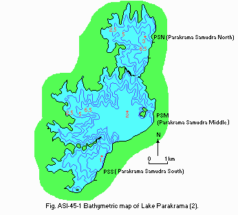
Bathymetric map (2).
- Water temperature [deg C](4)
| Station 3, 3 August 1980 | ||||||
| Depth [m] | Daytime | |||||
|---|---|---|---|---|---|---|
| 0600 | 0850 | 1230 | 1520 | 1830 | 2340 | |
| 0.0 | 30.0 | 31.0 | 33.8 | 34.2 | 31.6 | 30.6 |
| 0.5 | 30.2 | 30.5 | 32.3 | 34.0 | 31.8 | 30.7 |
| 1.0 | 30.2 | 30.3 | 32.0 | 32.1 | 31.6 | 30.7 |
| 1.5 | 30.2 | 30.2 | 31.2 | 31.8 | 31.3 | 30.7 |
| 2.0 | 30.2 | 30.2 | 30.8 | 31.2 | 31.0 | 30.6 |
| 2.5 | 30.1 | 29.6 | 30.6 | 30.4 | 31.1 | 30.6 |
| 3.0 | 29.3 | 29.4 | 30.3 | 29.2 | 31.1 | 30.6 |
| 3.5 | 29.1 | 29.3 | 30.0 | 29.2 | 30.6 | 30.6 |
| 3.8 | 29.0 | 29.3 | 30.0 | 29.2 | 29.9 | 30.6 |
| Inflow | 9,933 |
| Outflow | 10,067 |
| Precipitation | 1,849 |
| Evaporation | 1,786 |
| Change in storage | -133 |
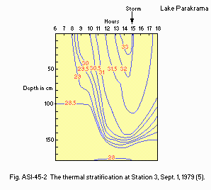
The thermal stratification at Station 3, 1 September 1979 (5).
E. LAKE WATER QUALITY
E2 pH (6)- Station 1: 8.6 (8.2-9.1).
Station 2: 8.4 (8.1-8.7).
Station 3: 8.6 (8.3-8.9).
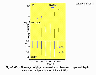
The ranges of pH, concentration of dissolved oxygen and depth penetration of light at Station 3, 1 September 1979 (5).
E6 CHLOROPHYLL CONCENTRATION [micro l-1](7)
- March-April 1980
Station 1: 20.0 (13.5-24.0).
Station 2: 14.1 (9.6-23.4).
Station 3: 16.3 (9.6-19.8).
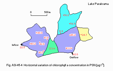
Horizontal variation of chlorophyll a concentration in PSN [micro l-1].
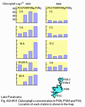
Chlorophyll a concentration in PSN, PSM and PSS. Location of each station is shown in the map.
E7 NITROGEN CONCENTRATION (6)
- Total-N [mg l-1]
Station 1, March-April 1980: 0.51 (0.39-0.62).
Station 2, March-April 1980: 0.59 (0.35-0.83).
Station 3, March-April 1980: 0.72 (0.49-0.95).
- Total-P [micro l-1]
March-April 1980
Station 1: 67 (51-81).
Station 2: 76 (48-91).
Station 3: 78 (48-107).
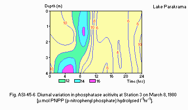
Diurnal variation in phosphatase activity at Station 3 on March 8, 1980 [u mol PNPP (p-nitrophenyl phosphate) hydrolysed l-1 hr-1].
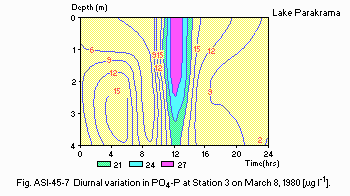
Diurnal variation in PO4-P at Station 3 on March 8, 1980 [micro l-1].
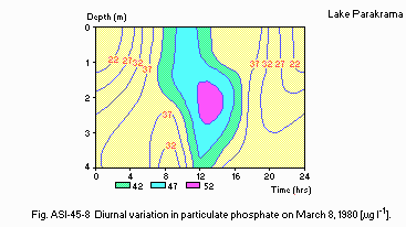
Diurnal variation in particulate phosphate on March 8, 1980 [micro l-1].
F. BIOLOGICAL FEATURES
F1 FLORA (8)- Phytoplankton
Anabaenopsis raciborskii, Lyngbya circumcreta, Melosira granulata, Synedra acus, Merismopedia punctata, Microcystis spp., Monoraphidium irregulare, Peridinium inconspicuum, Scenedesmus spp., Ankistrodesmus bibraianus, Coelastrum microporum, Pediastrum duplex, Tetraedron incus, Tetrastrum heteracanthum, Cosmarium depressum, Mougeotia sp., Staurastrum sp.
- Zooplankton (9)
Anuraeopsis coelata, Brachionus angularis, B. calyciflorus, B.falcatus, B. quadridentatus, B. rubens, Collotheca ornata, Filinia longiseta, Keratella tropica, Lecane bulla, Mytilina ventralis, Trichocerca similis, Diaphanosoma excisum, Ceriodaphnia cornuta, Alona verrucosa, Chydorus barroisi, Mesocyclops leuckarti, Phllodiaptomus annae, Arcella sp., Difflugia sp. - Fish (10)
Ehira fluviatilis, Amblypharyngodon melettinus, Danio aequipinnatus, Puntius sarana, P. dorsalis, P. filamentosus, Rasbora daniconius, Ompok bimaculatus, Mystus vittatus, Labeo dussumieri, Sarotheradon mossambicus, Etroplus suratensis, Glossogobius giuris, Mastacembelus armatus.
- Phytoplankton count, fresh-weight biomass and chlorophyll a concentration
for selected samples from 1979 and 1980 (7)
| Phytoplankton count [cells l-1 x1.0E+6] | Fresh wt. biomass [mg l-1] | Chlorophyll a [micro l-1] | |
|---|---|---|---|
| 1979 | 25.15-71.79 | 6.4-29.50 | 26.2-105.0 |
| 1980 | 8.42-129.99 | 1.99-20.53 | 5.3-20.8 |
- Diurnal changes in the abundance of the total rotifer community (5)
| Station 3, 1 September 1979 | ||
| Time of day | Numbers mill. m-2 | Numbers mill. m-3 |
|---|---|---|
| 0600 | 8.381 | 5.278 |
| 0800 | 8.832 | 5.514 |
| 1000 | 9.179 | 5.737 |
| 1200 | 6.233 | 3.896 |
| 1400 | 3.784 | 2.365 |
| 1600 | 5.792 | 3.622 |
| 1745 | 10.036 | 6.272 |
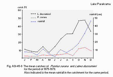
The mean catches of Puntius sarana and Labeo dussumieri for the period of 1975-1979. Also indicated is the mean rainfall in the catchment for the same period.
| List of species found in different habitats of the lake (10) | |||||
| Species | 1 | 2 | 3 | 4 | 5 |
|---|---|---|---|---|---|
| Ehirava fluviatilis | ++ | ++ | +++ | ++ | |
| Amblypharyngodon melettinus | ++ | +++ | + | +++ | |
| Danio aequipinnatus | ++ | +++ | |||
| Esomus danrica thermoicos | ++ | ||||
| Labeo dussumieri | + | + | + | ||
| Puntius chola | + | + | +++ | + | ++ |
| Puntius dorsalis | +++ | +++ | +++ | ++ | ++ |
| Puntius filamentosus | +++ | ++ | ++ | +++ | +++ |
| Puntius sarana | ++ | ++ | |||
| Rasbora daniconius | ++ | +++ | ++ | + | +++ |
| Ompok bimaculatus | + | + | + | + | |
| Heteropneustes fossilis | + | + | |||
| Mystus keletius | + | ++ | |||
| Mystus vittatus | + | + | ++ | + | + |
| Anquilla bicolor bicolor | + | ||||
| Anquilla nebulosa nebulosa | + | ||||
| Hemiramphidae sp. | ++ | + | ++ | ++ | |
| Ophiocephalus striatus | + | ||||
| Sarotherodon mossambicus | +++ | +++ | +++ | +++ | ++ |
| Etroplus maculatus | + | ||||
| Etroplus suratensis | ++ | + | + | ||
| Glossogobius giuris | ++ | ++ | + | + | ++ |
| Mastacembelus armatus | + | + | + | + | |
G. SOCIO-ECONOMIC CONDITIONS
G1 LAND USE IN THE CATCHMENT AREA (2)- Mostly covered by tropical rain forest.
H. LAKE UTILIZATION
H1 LAKE UTILIZATION (2)- Source of water (domestic use and irrigation) and fishery.
I. DETERIORATION OF LAKE ENVIRONMENTS AND HAZARDS (2)
I1 ENHANCED SILTATION- Extent of damage: Not serious.
- Present status: Suspected but no information.
- No evidence of progressive eutrophication.
J. WASTEWATER TREATMENTS (2)
J1 GENERATION OF POLLUTANTS IN THE CATCHMENT AREA- (e) Severe pollution with no wastewater treatment.
K. IMPROVEMENT WORKS IN THE LAKE (2)
- None.
L. DEVELOPMENT PLANS (2)
- The Mahaweli River Diversion Scheme is planned. This programme aims to improve and expand rice cultivation in the dry zone as well as increase hydro- electric power and control flooding. The scheme will make available an additional 200 km2 of reservoir area and change the hydrological regime of some of the major existing reservoirs, for example, Parakrama Samudra. Within the programme - a long-term project to improve irrigation within the Mahaweli basin - water from the Mahaweli is diverted via the Polgolla tunnel to Amban Ganga which is the largest river of Sri Lanka. Thus the actual catchment area comprises a broad spectrum of geographical regions.
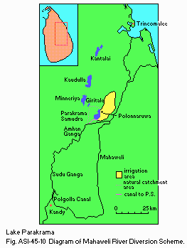
Diagram of the Mahaweli River Diversion Scheme.
M. LEGISLATIVE AND INSTITUTIONAL MEASURES FOR UPGRADING LAKE ENVIRONMENTS
M3 RESEARCH INSTITUTES ENGAGED IN THE LAKE ENVIRONMENT STUDIES (2)- University of Colombo
- University of Kelaniya
- Ruhuna University
- Ceylon Institute for Scientific and Industrial Research (CISIR)
N. SOURCES OF DATA
- Fernando, C. H. (1984) Reservoirs and lakes of Southeast Asia (Oriental region). "Ecosystems of the World 23, Lakes and Reservoirs" (ed. Taub, F. B.), pp. 411-446. Elsevier, Amsterdam-Oxford-New York-Tokyo.
- Schiemer, F. (1983) 1. The Parakrama Samudra Project: scope and objectives. "Limnology of Parakrama Samudra - Sri Lanka" (ed. Schiemer, F.), pp. 1-17. Dr. W. Junk Publishers, The Hague-Boston-London.
- Dobesch, H. (1983) 2. Energy and water budget of a tropical man-made lake. Ibid., pp. 19-26.
- Bauer, K. (1983) 3. Thermal stratification, mixis, and advective currents in the Parakrama Samudra Reservoir, Sri Lanka. Ibid., pp. 27-34.
- Duncan, A. & Gulati, R. D. (1983) 8. A diurnal study of the planktonic rotifer populations in Parakrama Samudra Reservoir, Sri Lanka. Ibid., pp. 95-106.
- Gunatilaka, A. (1983) 4. Phosphorus and phosphatase dynamics in Parakrama Samudra based on diurnal observations. Ibid., pp. 35-47.
- Dokulil, M., Bauer, K. & Silva, I. (1983) 5. An assessment of the phytoplankton biomass and primary productivity of Parakrama Samudra, a shallow man-made lake in Sri Lanka. Ibid., pp. 49-76.
- Rott, E. (1983) 20. A contribution to the phytoplankton species composition of Parakrama Samudra, an ancient man-made lake in Sri Lanka. Ibid., pp. 210-232.
- Fernando, C. H. & Rajapaksa, R. (1983) 6. Some remarks on long-term and seasonal changes in the zooplankton of Parakrama Samudra. Ibid., pp. 77 84.
- Schiemer F. & Hofer, R. (1983) 12. A contribution to the ecology of the fish fauna of the Parakrama Samudra Reservoir. Ibid., pp. 135-154.
- De Silva, S. S. (1983) 17. Reproductive strategies of some major fish species in Parakrama Samudra Reservoir and their possible impact on the ecosystem - a theoretical consideration. Ibid., pp. 185-191.
