NOJIRI-KO (LAKE NOJIRI)
Looking down the lake from the east
with mt.Kurohime in the background
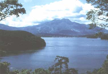
Photo: A.Kurata
A. LOCATION
- Nagano Prefecture, Japan.
- 36:49N, 138:13E; 654 m above sea level.
B. DESCRIPTION
Lake Nojiri is a dammed lake formed by the debris ejected from the volcano Mt. Kurohime located to the west of the lake. The southern part of this picturesque mountain lake, resembling a hibiscus flower in its outline, began to develop into a resort area as early as in the Taisho era (1912-1926). The lakeshore has become further intensively used to accommodate resort facilities and recreational activities, and now accepts 750,000 visitors annually.
The lake water flows out through the R. Ikejiri, which has been a source of irrigation water since 17th century. It is also one of the water sources of Nagano City, supplying 10,000 tons day-1 of water to the city since 1954 except for the summer season between June and September. The fishery on the lake provides rich fish harvest including wakasagi (Hypomesus transpacificus) and dace (Leuciscus hakonensis). Aside from water supply, fishery and recreation, power generation is also an important use of the lake water. The fossils of Naumann elephant, known to have lived some 20,000 years ago, are excavated frequently from the lake's shallow bottom.
The lake has no large inflowing stream and is mainly fed by underground water. Therefore, the lake had long remained oligotrophic, but the use of the lake water for hydroelectric power generation led to a wide range of water level fluctuation, and this, together with lakeshore development, is mainly responsible for increasing trend of pollution.
C. PHYSICAL DIMENSIONS (Q)
| Surface area [km2] | 5 |
| Volume [km3] | 0.095676 |
| Maximum depth [m] | 38.5 |
| Mean depth [m] | 21 |
| Water level | Regulated |
| Normal range of annual water level fluctuation [m] | 6.4 |
| Length of shoreline [km] | 13.6 |
| Residence time [yr] | 2.0 |
| Catchment area [km2] | 8 |
D. PHYSIOGRAPHIC FEATURES
D1 GEOGRAPHICAL (Q)
- Bathymetric map: Fig. ASI-43-01.
- Names of main islands: Biwa-Jima (13,494 m2).
- Number of outflowing rivers and channels (name): 1 (Ikejiri R.).
D2 CLIMATIC (6)
- Climatic data at Shinano-cho, 1971-1982
| Jan | Feb | Mar | Apr | May | Jun | Jul | Aug | Sep | Oct | Nov | Dec |
| Mean temp. [deg C] | -3.2 | -2.7 | 0.5 | 7.9 | 13.2 | 17.6 | 21.6 | 22.2 | 17.6 | 11.2 | 5.4 | -0.2 |
| Precipitation [mm] | 146 | 119 | 107 | 85 | 94 | 149 | 152 | 153 | 125 | 85 | 90 | 114 |
- Number of hours of bright sunshine: 2,112 hr yr-1.
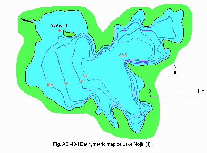
Fig. ASI-43-01
Bathymetric map [m](1).
- Water temperature [deg C](2)
| Station 1, 1983-1985 |
| Depth [m] | Jan | Feb | Mar | Apr | May | Jun | Jul | Aug | Sep | Oct | Nov | Dec |
| 0.5 | 1.3 | - | 1.6*1 | 7.0 | 13.7 | 18.8 | 22.8 | 24.8 | 20.5 | 14.5 | 9.4 | 3.6 |
| *2 | 1.3 | - | 1.2*3 | 6.2 | - | - | 21.9 | - | - | 13.9 | - | - |
*1 1984-1985. *2 3.2-6.9. *3 1985.
- Freezing period: January-March.
- Mixing type: Dimictic.
E. LAKE WATER QUALITY (2)
E1 TRANSPARENCY [m]
| Station 1, 1983-1985 |
| Depth [m] | Jan | Feb | Mar | Apr | May | Jun | Jul | Aug | Sep | Oct | Nov | Dec |
| 3.8 | - | 4.0* | 3.8 | 3.9 | 5.4 | 5.3 | 3.9 | 5.1 | 4.2 | 5.3 | 4.0 |
* 1984-1985.
E2 pH
| Station 1, 1983-1985 |
| Depth [m] | Jan | Feb | Mar | Apr | May | Jun | Jul | Aug | Sep | Oct | Nov | Dec |
| 0.5 | 7.5 | - | 5.0*1 | 7.2 | 7.8 | 7.8 | 7.8 | 7.6 | 7.7 | 7.8 | 7.5 | 7.4 |
| *2 | 7.4 | - | 4.2*3 | 7.2 | - | - | 7.8 | - | - | 7.8 | - | - |
*1 1984-1985. *2 3.2-6.9. *3 1985.
E3 SS [mg l-1]
| Station 1, 1983-1985 |
| Depth [m] | Jan | Feb | Mar | Apr | May | Jun | Jul | Aug | Sep | Oct | Nov | Dec |
| 0.5 | 2 | - | <1*1 | 2 | 2 | 1 | 1 | 1 | 2 | 1 | 1 | 3 |
| *2 | 2 | - | <1*3 | 2 | - | - | 2 | - | - | 2 | - | - |
*1 1984-1985. *2 3.2-6.9. *3 1985.
E4 DO [mg l-1]
| Station 1, 1983-1985 |
| Depth [m] | Jan | Feb | Mar | Apr | May | Jun | Jul | Aug | Sep | Oct | Nov | Dec |
| 0.5 | 11 | - | 12*1 | 10 | 9.9 | 8.3 | 8.0 | 7.0 | 7.8 | 9.3 | 10 | 9.7 |
| *2 | 11 | - | 11*3 | - | - | - | 7.9 | - | - | 9.4 | - | - |
* 1984-1985. *2 3.2-6.9. *3 1985.
E5 COD [mg l-1]
Determined by KMnO4 method.
| Station 1, 1983-1985 |
| Depth [m] | Jan | Feb | Mar | Apr | May | Jun | Jul | Aug | Sep | Oct | Nov | Dec |
| 0.5 | 1.5 | - | 1.5*1 | 1.3 | 1.6 | 1.1 | 1.4 | 1.7 | 1.3 | 1.3 | 1.8 | 1.4 |
| *2 | 1.4 | - | 1.5*3 | 1.4 | - | - | 1.6 | - | - | 1.6 | - | - |
*1 1984-1985. *2 3.2-6.9. *3 1985
E7 NITROGEN CONCENTRATION
| Station 1, 1983-1985 |
| Depth [m] | Jan | Feb | Mar | Apr | May | Jun | Jul | Aug | Sep | Oct | Nov | Dec |
| 0.5 | - | - | .12*1 | - | - | - | .12 | - | - | - | - | - |
| *2 | - | - | - | - | - | - | .13 | - | - | - | - | - |
*1 1983 and 1985. *2 3.2-6.9.
E8 PHOSPHORUS CONCENTRATION
| Station 1, 1983-1985 |
| Depth [m] | Jan | Feb | Mar | Apr | May | Jun | Jul | Aug | Sep | Oct | Nov | Dec |
| 0.5 | - | - | .018*1 | - | - | - | .008 | - | - | - | - | - |
| *2 | - | <.005 | - | - | - | - | .015 | - | - | - | - | - |
*1 1984-1985. *2 3.2-6.9.
F. BIOLOGICAL FEATURES
F1 FLORA (4)
- Phytoplankton
Melosira italica, M. variano, Fragilaria crotonensis, Asterionella spp., Tabellaria fenestrata, Cyclotella spp., Chlamydomonas spp., Staurastrum spp.
F2 FAUNA
- Zooplankton (4)
Ceratium hirundinella, Difflugia bacillifera, Pseudodiffugia horrida, Keratella cochlearis, Polyarthra trigla.
- Benthos: Chironomus plumosus (3).
- Fish (Q)
Hypomesus transpacificus, Carassius carassius, Cyprinus carpio, Anguilla japonica, Leuciscus (Tribolodon) hakonensis.
F5 FISHERY PRODUCTS (Q)
- Annual fish catch [metric tons]
1985: 6.8.
- Fishery products other than fish: None.
F6 PAST TRENDS: Fig. ASI-43-02 (Q).
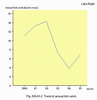
Fig. ASI-43-02
Trend of annual fish catch.
F7 NOTES ON REMARKABLE CHANGES OF BIOTA IN THE LAKE IN RECENT YEARS (4)
Water plants were extinguished because of Ctenopharyngodon idella released in
1978.
G. SOCIO-ECONOMIC CONDITIONS
G1 LAND USE IN THE CATCHMENT AREA (Q) (1985)
| Area [km2] | [%] |
| Natural landscape |
| - Woody vegetation | 184,19 | 91.8 |
| - Herbaceous vegetation |
| - Swamp |
| - Others |
| Agricultural land |
| - Crop field | 4.549 | 2.3 |
| - Pasture land |
| Others | 11.841 | 5.9 |
| Total | 200.58 | 100.0 |
- Types of important woody vegetation (5)
Deciduous broadleaf forest (Quercus serrata, Q. mongolica v. grosseserrata), pine forest (Pinus densiflora), conifer plantation (Cryptomenia japonica, Chamaecyparis obtusa, C. pisifera).
- Main kinds of crops: Rice and vegetable (5).
- Numbers of domestic animals in the catchment area: Cattle 381 (1).
G3 POPULATION IN THE CATCHMENT AREA (1) (1986)
| Population | Population density [km-2] | Major cities (population) |
| Total | 3,576 | 17.8? | None |
H. LAKE UTILIZATION
H1 LAKE UTILIZATION (Q)
Source of water, tourism (no. of visitor in 1985: 748,000), recreation (swimming, sport-fishing, yachting) and fisheries.
H2 THE LAKE AS WATER RESOURCE (1985)
| Use rate [m3 sec-1] |
| Domestic | 0.111 |
| Irrigation | 1.070 |
| Power plant | 2.850 |
I. DETERIORATION OF ENVIRONMENTS AND HAZARDS (Q)
I3 EUTROPHICATION
- Nuisance caused by eutrophication
Clogging of sand filters in water treatment systems.
J. WASTEWATER TREATMENTS (Q)
J3 SANITARY FACILITIES AND SEWERAGE
- Municipal wastewater treatment systems: 1.
L. DEVELOPMENT PLANS (Q)
The health resort plan (total area: 113.3 ha) has been carried out by a private enterprise around the lake from 1984 to 1987.
M. LEGISLATIVE AND INSTITUTIONAL MEASURES FOR UPGRADING LAKE ENVIRONMENTS
M1 NATIONAL AND LOCAL LAWS CONCERNED (1)
- Names of the laws (the year of legislation)
- For national laws see "Biwa-ko".
- Nagano Prefecture Environmental Pollution Control Ordinance
- Responsible authorities
- Nagano Prefectural Government
M3 RESEARCH INSTITUTES ENGAGED IN THE LAKE ENVIRONMENT STUDIES
- Nagano Research Institute for Health and Pollution
N. SOURCES OF DATA
- Questionnaire filled by Nagano Prefectural Government.
- Tanaka, A. (1929) Study on Lake Nojiri (Nojiri-ko no Kenkyu). 636 pp. Shinano Kyoiku-kai.
- Nagano Prefectural Government. Water Quality Monitoring Results of Public Water Bodies ( Kokyo Yosuiiki Suishitsu Sokutei Kekka ), 1983-1985.*
- Nagano Prefectural Government (1985) The Third Baseline Survey of the State of Natural Environment Conservation, Report Lake Research (Dai 3-kai Shizenkankyo Hozen Kiso Chosa, Kosho Chosa Hokokusho), pp. 33-38.*
- Ochiai, T. (1984) Lakes in Shinshu (Shinshu no Kosho), pp. 130-147. Shinano Kyoiku-kai.*
- Nagano Prefectural Government (1973, 1974) Vegetation Map of Nagano Prefecture Vol. I, II (Nagano-ken no Shokusei-zu Dai 1, 2 shu).*
- Uchida, E., Asakura, T. & Kawamura, T. (ed.) Meteorological Survey of Japan, II (Nihon Kisho Soran Gekan), 1060 pp. Toyo Keizai Shinpo-sha, Tokyo.*
* Printed in Japanese. The titles are tentatively translated into English with the original titles in romanized Japanese in parentheses.

