OZE-NUMA (LAKE OZE)
An aerial view of the whole lake with Mt.Hiuchi
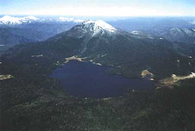
Photo: Fukushima Prefectural Government
A. LOCATION
- Gunma and Fukushima Prefectures, Japan.
- 36:56N, 139:18E; 1,665 m above sea level.
B. DESCRIPTION
The Oze district is a wilderness area composed of Lake Oze or Oze-numa and Ozegahara moorland. Oze-numa is a small montane lake with a total shoreline length of about 7 km and a surface area of 1.7 km2. It is located at an altitude of 1,665 m across the prefectural boundary between Fukushima and Gunma, while Ozegahara moor extends over the three prefectures, Fukushima, Gunma and Niigata. The entire Oze area was designated as the 4th National Park of Japan in 1924, the 12th Wildlife Reserve Area in 1953, and a Special Natural Monument in 1960, based on the Cultural Properties Protection Law.
Some eleven thousand years ago, the eruption of Mt. Hiuchi, a volcano to the NE of the present lake, emitted a vast amount of ejecta eastward blocking the Tadami River to form a lake called Old Ozegahara Lake, which has since been filled up and turned into Ozegahara moor. The present Oze-numa was produced later toward the end of the volcanic activity by the southward lava flow that blocked the Numajiri River. The lake is believed to have been much deeper originally, but sediment loads eroded from Mt. Hiuchi made it shallower and produced an extensive marshy area around the lake.
The Oze area is one of the cores of Nikko National Park, and is known as the symbol of nature protection movement in Japan. It is blessed with fascinating natural beauty and is called the treasure box of mountain flora. Over nine million tourists visit this area annually, particularly during the blooming season of wild plants. However, the increase of visitors due to improved transportation in recent years, together with the wastewater discharge from tourist lodges and the invasion of an exotic waterweed Elodea canadensis into the lake, has resulted in the progressive disruption of pristine environments to a serious extent (Q1, Q2).
C. PHYSICAL DIMENSIONS (Q1)
| Surface area [km2] | 2 |
| Volume [km3] | 0.0066 |
| Maximum depth [m] | 9.5 |
| Mean depth [m] | 4.1 |
| Water level | Regulated |
| Normal range of annual water level fluctuation [m] | 3 |
| Length of shoreline [km] | 6.0 |
| Residence time [yr] | 0.3 |
| Catchment area [km2] | 13 |
D. PHYSIOGRAPHIC FEATURES (Q1)
D1 GEOGRAPHICAL
- Bathymetric map: Fig. ASI-41-01.
- names of main islands: None.
- Number of outflowing rivers and channels (name)
2 (Numajiri R. and Katashina R. (outlet to power plant)).
D2 CLIMATIC
- Climatic data at Hinoemata, 1984-1986
| Jan | Feb | Mar | Apr | May | Jun | Jul | Aug | Sep | Oct | Nov | Dec | Ann. |
| Mean temp. [deg C] | -6.1 | -5.3 | -1.8 | 4.7 | 11.2 | 15.4 | 19.3 | 20.8 | 15.6 | 8.4 | 3.2 | -1.5 | 7.0 |
| Precipitation [mm] | 108 | 128 | 87 | 86 | 82 | 140 | 207 | 108 | 143 | 127 | 97 | 95 | 1,408 |
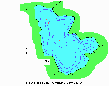
Fig. ASI-41-01
Bathymetric map (Q1).
- Water temperature [deg C]
| Station 1 |
| Depth [m] | Jan | Feb | Mar | Apr | May | Jun | Jul | Aug | Sep | Oct | Nov | Dec |
| 0.5 | - | - | - | - | 5.0 | 13.1 | 17.8 | 22.6 | 19.3 | 12.9 | - | - |
| 3.0 | - | - | - | - | 4.7 | 12.3 | 16.4 | 21.0 | 19.1 | 12.6 | - | - |
| 6.0 | - | - | - | - | 4.6 | 8.1 | 10.7 | 12.4 | 14.2 | 12.1 | - | - |
- Freezing period: December-May.
- Mixing type: Dimictic.
E. LAKE WATER QUALITY
E1 TRANSPARENCY [m](Q1)
| Station 1, 1984-1986 |
| Depth [m] | Jan | Feb | Mar | Apr | May | Jun | Jul | Aug | Sep | Oct | Nov | Dec |
| - | - | - | - | 3.0 | 3.8 | 4.7 | 4.1 | 4.4 | 3.2 | - | - |
E2 pH (Q1)
| Station 1, 1984-1986 |
| Depth [m] | Jan | Feb | Mar | Apr | May | Jun | Jul | Aug | Sep | Oct | Nov | Dec |
| 0.5 | - | - | - | - | 6.9 | 7.1 | 6.9 | 7.0 | 7.1 | 7.3 | - | - |
| 3.0 | - | - | - | - | 6.8 | 7.0 | 6.8 | 6.8 | 7.0 | 7.2 | - | - |
| 6.0 | - | - | - | - | 6.7 | 6.6 | 6.4 | 6.3 | 6.5 | 7.0 | - | - |
E3 SS [mg l-1](Q1)
| Station 1, 1984-1986 |
| Depth [m] | Jan | Feb | Mar | Apr | May | Jun | Jul | Aug | Sep | Oct | Nov | Dec |
| 0.5 | - | - | - | - | 2 | 2 | 1 | 1 | 2 | 3 | - | - |
| 3.0 | - | - | - | - | 4 | 2 | 1 | 1 | 2 | 3 | - | - |
| 6.0 | - | - | - | - | 1 | 3 | 2 | 2 | 3 | 4 | - | - |
E4 DO [mg l-1](Q1)
| Station 1, 1984-1986 |
| Depth [m] | Jan | Feb | Mar | Apr | May | Jun | Jul | Aug | Sep | Oct | Nov | Dec |
| 0.5 | - | - | - | - | 8.8 | 9.1 | 7.8 | 7.7 | 7.8 | 8.3 | - | - |
| 3.0 | - | - | - | - | 8.7 | 9.0 | 7.9 | 7.6 | 7.5 | 8.4 | - | - |
| 6.0 | - | - | - | - | 8.5 | 8.2 | 7.4 | 5.8 | 5.9 | 8.2 | - | - |
E5 COD [mg l-1](Q1)
| Station 1, 1984-1986 |
| Depth [m] | Jan | Feb | Mar | Apr | May | Jun | Jul | Aug | Sep | Oct | Nov | Dec |
| 0.5 | - | - | - | - | 2.4 | 2.5 | 2.9 | 3.1 | 2.4 | 3.8 | - | - |
| 3.0 | - | - | - | - | 2.6 | 2.6 | 2.8 | 3.9 | 3.0 | 4.0 | - | - |
| 6.0 | - | - | - | - | 2.6 | 2.5 | 2.7 | 2.5 | 2.3 | 3.9 | - | - |
E6 CHLOROPHYLL CONCENTRATION [micro l-1](Q2)
| Station 1, 1986 |
| Depth [m] | Jan | Feb | Mar | Apr | May | Jun | Jul | Aug | Sep | Oct | Nov | Dec |
| 0 | - | - | - | - | 2.7 | 1.4 | 2.4 | 1.1 | 4.0 | 3.0 | - | - |
| 3.0 | - | - | - | - | 1.9 | 3.0 | 2.8 | 1.2 | 3.0 | 3.9 | - | - |
| 6.0 | - | - | - | - | 0.9 | 9.5 | 2.4 | 3.7 | 2.6 | 3.9 | - | - |
E7 NITROGEN CONCENTRATION (Q1)
| Station 1, 1984-1986 |
| Depth [m] | Jan | Feb | Mar | Apr | May | Jun | Jul | Aug | Sep | Oct | Nov | Dec |
| 0.5 | - | - | - | - | 0.20 | 0.26 | 0.17 | 0.11 | 0.09 | 0.19 | - | - |
| 3.0 | - | - | - | - | 0.26 | 0.29 | 0.14 | 0.14 | 0.15 | 0.18 | - | - |
| 6.0 | - | - | - | - | 0.21 | 0.23 | 0.17 | 0.20 | 0.09 | 0.19 | - | - |
E8 PHOSPHORUS CONCENTRATION (Q1)
| Station 1, 1984-1986 |
| Depth [m] | Jan | Feb | Mar | Apr | May | Jun | Jul | Aug | Sep | Oct | Nov | Dec |
| 0.5 | - | - | - | - | 0.007 | 0.007 | 0.015 | 0.008 | 0.010 | 0.010 | - | - |
| 3.0 | - | - | - | - | 0.009 | 0.014 | 0.007 | 0.007 | 0.008 | 0.010 | - | - |
| 6.0 | - | - | - | - | 0.008 | 0.006 | 0.010 | 0.012 | 0.009 | 0.010 | - | - |
F. BIOLOGICAL FEATURES
F1 FLORA
- Emerged macrophytes: Phragmites communis (Q2).
- Floating macrophytes: Nymphaea tetragona, Brasenia schreberi.
- Submerged macrophytes (Q1, Q2)
Elodea nuttallii, Potamogeton oxyphyllus, P. perfoliatus, P. maackianus, Hippuris vulgaris, Chara delicatula.
- Phytoplankton (Q2)
Selenastrum sp., Chlamydomonas sp., Melosira sp., Peridinium sp.
F2 FAUNA
- Zooplankton (Q2)
Bosmina longirostris, Honopedium gibberum, Asplanchna sp., Graptoleberis testudinaria.
- Benthos (Q2)
Austropeplea olulla, Goera japonica, Molanna falcata, Chironomus plumosus, Tubifex hattai, Hydridae.
- Fish (Q1, Q2)
Salvelinus leucomaenis f. pluvius, Onchorhynchus masou masou, Salmo gairdneri, Carassius auratus, Cyprinus carpio, Phoxinus lagowskii f. steindachneri, Hypomesus pretiosus, Misgurnus fossilis anguillicaudatus.
F7 NOTES ON THE REMARKABLE CHANGES OF BIOTA IN THE LAKE IN RECENT YEARS (Q2)
Elodea nuttallii from North America has been conspicuous since 1982. Measures are being taken to meet its dominance among submerged plants.
G. SOCIO-ECONOMIC CONDITIONS (Q1)
G1 LAND USE IN THE CATCHMENT AREA
- Main types of woody vegetation: Evergreen conifer forest (Abies mariesii).
- Main types of herbaceous vegetation
Swamp (Sphagnum, Vaccinium oxycoccus, Moliniopsis japonica).
G3 POPULATION IN THE CATCHMENT AREA (Q1) (1979)
| Population | Population density [km-2] | Major cities (population) |
| Total | 62 | 4.6 | None |
H. LAKE UTILIZATION (Q1)
H1 LAKE UTILIZATION
Source of water for hydroelectric power generation and tourism (no. of visitors in 1986: 550,000).
H2 THE LAKE AS WATER RESOURCE
- Use rate for power plant in 1986 [m3 sec-1]: 0.480.
I. DETERIORATION OF LAKE ENVIRONMENTS AND HAZARDS
I1 ENHANCED SILTATION (Q1, Q2)
- Extent of damage: Not detected.
I2 TOXIC CONTAMINATION (Q2)
- Present status: Not available.
I4 ACIDIFICATION (Q2)
J. WASTEWATER TREATMENTS (Q2)
J1 GENERATION OF POLLUTANTS IN THE CATCHMENT AREA
(f) Discharge from tourist lodges has become unnegligible.
J2 APPROXIMATE PERCENTAGE DISTRIBUTION OF POLLUTANT LOADS
| [%] |
| Natural fall | 70.2 |
| Discharge from cottages 29.8 |
| Total | 100 |
M. LEGISLATIVE AND INSTITUTIONAL MEASURES FOR UPGRADING LAKE ENVIRONMENTS (Q2)
M1 NATIONAL AND LOCAL LAWS CONCERNED
- Names of the laws (the year of legislation)
- For national laws see "Biwa-ko"
- Gunma Prefectural Pollution Control Ordinance (1971)
- Responsible authorities
- Gunma Prefectural Government
- Main items of control
pH, COD, SS, no. of coliform groups
M3 RESEARCH INSTITUTES ENGAGED IN THE LAKE ENVIRONMENT STUDIES
- Gunma Institute of Public Health
N. SOURCES OF DATA
- Questionnaire filled by Fukushima Prefectural Government. (Q1)
- Questionnaire filled by Gunma Prefectural Government. (Q2)
- Japanese Environment Agency (1987) Report of the 3rd National Survey on the Natural Environment; Lakes and Reservoirs survey, Gunma Prefecture (Dai-3-kai Shizen Kankyo Hozen Kiso Chosa, Kosho Chosa Hokoku-sho, Gunma ken).*
- Gunma Institute of Public Health (1986) Annual Report of Gunma Institute of Public Health for 1985 (Showa 60-nendo Gunma-ken Eisei Kogai Kenkyusho Nenpo), 17: 152-164.*
* Printed in Japanese. The titles are tentatively translated into English with the original titles in romanized Japanese in parentheses.

