
LAKE SAGULING
A view on the lake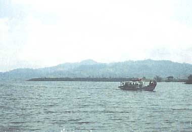
Photo: E. Brotoisworo
A. LOCATION
- Jawa Barat, Indonesia.
- 6:50S, 107:25E; 643 m above sea level.
B. DESCRIPTION
-
The Saguling is an artificial lake. It is located about 40 km from Bandung city, or about 12 km to the south of the main road from Bandung to Jakarta, and about 90 km at the upstream of the Jatiluhur Lake. The lake was built on the Citarum River, the largest river in West Java Province, in February 1985.
Originally, the Saguling was planned for a single purpose dam to generate electricity. At the first stage the plant was built with an installed capacity of 700 MW, but if the demand of electricity might increasing in the future the plant could be extended to produce 1,400 MW. The responsible body in charge of construction is "Proyek Induk Pembangkit Hidro" abbreviated as PIKITDRO (Main Project of Hydroelectric Development) of the State Electrical Company, of the Ministry of Mining and Energy. Later, considering the environmental problems of the area, the Saguling was re-planned as a multipurpose dam, which included the use of the lake created by the project for other development purposes such as fisheries, agri-aquaculture, tourism and their multiple effects. But, at present, the lake is also used for domestic purposes such as bathing and washing, or also for toilet.
The surrounding area of Lake Saguling is hilly, while the river has many tributaries at this location. This makes the shape of Lake Saguling very irregular or dendritic, with many extended bays. The lake area was formerly densely populated by farmer population with extensive agricultural lands. The catchment areas of the lake or the upper Citarum River basin are faced with high population pressure. This is because over 50% of the population consists of farmers with a high annual growth rate (2.34% is the national average). The growth of farmer population has caused the decrease of landholding and this condition forced them to extend their agricultural land by forest clearing and utilize marginal lands. As a consequence, there is a prevailing problem of floods accompanied by accelerated soil erosion in rainy seasons. The Institute of Ecology at Bandung has been studying the area since 1978, dealing with basic conditions of the area and also environmental monitoring and management for enhancing the living standard of the population.
Due to the high population density in the upper catchment of the lake, extensive agricultural land, soil erosion and the presence of industries,the lake water became polluted and eutrophic. The growth of aquatic weeds has been accelerated,with frequent blooms of Microcystis algae. The water is also contaminated by heavy metals, pesticides, etc. An extensive growth of water- hyacinth is maintained by fencing to reduce pollutant contents of water at inlets of the Citarum River (Q).
C. PHYSICAL DIMENSIONS (1)
| Surface area [km2] | 53 |
| Volume [km3] | 2.75 |
| Maximum depth [m] | 92 |
| Water level | Regulated |
| Normal range of annual water | |
| - level fluctuation [m] | 20 |
| Length of shoreline [km] | 417 |
| Catchment area [km2] | 452 |
D. PHYSIOGRAPHIC FEATURES
D1 GEOGRAPHICAL- Bathymetric map: Fig. ASI-39-01.
- Names of main islands: Pasir Banteng (0.4 km2).
- Number of outflowing rivers and channels (name): 1 (Citarum R.).
- Climatic data (2)
| Jan | Feb | Mar | Apr | May | Jun | Jul | Aug | Sep | Oct | Nov | Dec | Ann. | |
|---|---|---|---|---|---|---|---|---|---|---|---|---|---|
| Mean temp. [deg C]*1 | 22.6 | 22.6 | 22.9 | 23.2 | 23.4 | 23.0 | 22.6 | 22.9 | 23.2 | 23.3 | 22.9 | 22.8 | 23.0 |
| Precipitation [mm]*2 | 261 | 236 | 261 | 255 | 216 | 63 | 69 | 57 | 119 | 226 | 294 | 256 | 2,313 |
- Number of hours of bright sunshine: 2,226 hr yr-1.
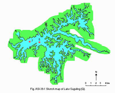
Bathymetric map (Q).
- Water temperature [deg C](Q)
| Station 5, 1986 | ||||||||||||
| Depth [m] | Jan | Feb | Mar | Apr | May | Jun | Jul | Aug | Sep | Oct | Nov | Dec |
|---|---|---|---|---|---|---|---|---|---|---|---|---|
| 0 | 30.0 | - | 30.0 | - | 25.0 | - | 28.0 | 26.5 | 27.5 | 31.0 | 27.5 | - |
| 5 | 28.1 | - | 26.3 | - | 28.6 | - | 26.2 | 25.9 | 26.2 | 27.5 | 27.0 | - |
| Station 7, 1986 | ||||||||||||
| Depth [m] | Jan | Feb | Mar | Apr | May | Jun | Jul | Aug | Sep | Oct | Nov | Dec |
|---|---|---|---|---|---|---|---|---|---|---|---|---|
| 0 | 26.7 | - | 34.0 | - | 25.0 | - | 27.5 | 27.0 | 27.0 | 26.0 | 31.5 | - |
| 5 | 26.2 | - | 27.0 | - | 26.9 | - | 26.1 | 25.9 | 26.0 | 27.0 | 26.2 | - |
- Freezing period: None.
- Mixing type: Oligomictic.
E. LAKE WATER QUALITY (Q)
E1 TRANSPARENCY [m]| Station 5, 1986 | ||||||||||||
| Depth [m] | Jan | Feb | Mar | Apr | May | Jun | Jul | Aug | Sep | Oct | Nov | Dec |
|---|---|---|---|---|---|---|---|---|---|---|---|---|
| 1.3 | - | 0.7 | - | 2.0 | - | 1.3 | 1.3 | 1.5 | 1.5 | 2.0 | - | |
| Station 7, 1986 | ||||||||||||
| Depth [m] | Jan | Feb | Mar | Apr | May | Jun | Jul | Aug | Sep | Oct | Nov | Dec |
|---|---|---|---|---|---|---|---|---|---|---|---|---|
| 0.8 | - | 1.5 | - | - | - | - | - | 1.5 | 1.5 | 2.0 | - | |
| Station 5, 1986 | ||||||||||||
| Depth [m] | Jan | Feb | Mar | Apr | May | Jun | Jul | Aug | Sep | Oct | Nov | Dec |
|---|---|---|---|---|---|---|---|---|---|---|---|---|
| 0 | 7.3 | - | 8.0 | - | 8.0 | - | 7.8 | 7.2 | 7.7 | 7.4 | 6.3 | - |
| 5 | 7.2 | - | 7.2 | - | 7.7 | - | 6.6 | 6.7 | 7.4 | 6.4 | 6.2 | - |
| Station 7, 1986 | ||||||||||||
| Depth [m] | Jan | Feb | Mar | Apr | May | Jun | Jul | Aug | Sep | Oct | Nov | Dec |
|---|---|---|---|---|---|---|---|---|---|---|---|---|
| 0 | 7.6 | - | 8.2 | - | 8.3 | - | 7.7 | 8.4 | 7.6 | - | 7.2 | - |
| 5 | 7.2 | - | 7.4 | - | 7.9 | - | 7.5 | 7.4 | 7.0 | - | 7.4 | - |
| Station 5, 1986 | ||||||||||||
| Depth [m] | Jan | Feb | Mar | Apr | May | Jun | Jul | Aug | Sep | Oct | Nov | Dec |
|---|---|---|---|---|---|---|---|---|---|---|---|---|
| 0 | 8.7 | - | 11.0 | - | 6.9 | - | 7.9 | 7.9 | 8.0 | 7.8 | 7.8 | - |
| 5 | 6.9 | - | 4.7 | - | 6.8 | - | 1.5 | 6.3 | 2.2 | 7.8 | 5.1 | - |
| Station 7, 1986 | ||||||||||||
| Depth [m] | Jan | Feb | Mar | Apr | May | Jun | Jul | Aug | Sep | Oct | Nov | Dec |
|---|---|---|---|---|---|---|---|---|---|---|---|---|
| 0 | 7.2 | - | 7.4 | - | 7.5 | - | 8.8 | 9.6 | 6.7 | 8.1 | 8.5 | - |
| 5 | 7.2 | - | 1.3 | - | 5.5 | - | 3.7 | 3.4 | 1.6 | 3.9 | 2.8 | - |
-
Determined by KMnO4 method.
| Station 5, 1986 | ||||||||||||
| Depth [m] | Jan | Feb | Mar | Apr | May | Jun | Jul | Aug | Sep | Oct | Nov | Dec |
|---|---|---|---|---|---|---|---|---|---|---|---|---|
| 0 | 29.8 | - | 29.6 | - | 18.4 | - | 24.5 | 22.3 | 24.8 | 20.9 | 24.5 | - |
| 5 | 31.4 | - | 26.4 | - | 16.9 | - | 16.9 | 13.2 | 24.8 | 21.7 | 32.7 | - |
| Station 7, 1986 | ||||||||||||
| Depth [m] | Jan | Feb | Mar | Apr | May | Jun | Jul | Aug | Sep | Oct | Nov | Dec |
|---|---|---|---|---|---|---|---|---|---|---|---|---|
| 0 | 28.1 | - | 28.0 | - | 12.3 | - | 18.4 | 18.4 | 27.9 | 17.4 | 24.5 | - |
| 5 | 42.1 | - | 15.6 | - | 15.4 | - | 15.3 | 15.3 | 27.9 | 27.9 | 35.4 | - |
- Total-N [mg l-1]
| Station 5, 1986 | ||||||||||||
| Depth [m] | Jan | Feb | Mar | Apr | May | Jun | Jul | Aug | Sep | Oct | Nov | Dec |
|---|---|---|---|---|---|---|---|---|---|---|---|---|
| 0 | 1.1 | - | - | - | 0.6 | - | 1.3 | 1.3 | 1.5 | 1.5 | - | - |
| 5 | 1.3 | - | - | - | 0.7 | - | 1.4 | 1.2 | 2.4 | 0.6 | - | - |
| Station 7, 1986 | ||||||||||||
| Depth [m] | Jan | Feb | Mar | Apr | May | Jun | Jul | Aug | Sep | Oct | Nov | Dec |
|---|---|---|---|---|---|---|---|---|---|---|---|---|
| 0 | 1.6 | - | - | - | 1.2 | - | 1.2 | 1.4 | 1.1 | 0.4 | 0.4 | - |
| 5 | 0.9 | - | - | - | 1.1 | - | 1.3 | 0.8 | 1.4 | 0.2 | 0.4 | - |
- Total-P [mg l-1]
| Station 5, 1986 | ||||||||||||
| Depth [m] | Jan | Feb | Mar | Apr | May | Jun | Jul | Aug | Sep | Oct | Nov | Dec |
|---|---|---|---|---|---|---|---|---|---|---|---|---|
| 0 | 0.2 | - | 0.2 | - | 1.0 | - | 0.5 | 0.4 | 0.1 | 0.4 | 0.3 | - |
| 5 | 0.2 | - | 0.1 | - | 0.8 | - | 0.2 | 0.5 | 0.2 | 0.4 | 0.2 | - |
| Station 7, 1986 | ||||||||||||
| Depth [m] | Jan | Feb | Mar | Apr | May | Jun | Jul | Aug | Sep | Oct | Nov | Dec |
|---|---|---|---|---|---|---|---|---|---|---|---|---|
| 0 | 0.2 | - | 0.3 | - | 0.6 | - | 0.5 | 0.4 | 0.1 | 0.3 | 0.3 | - |
| 5 | 0.2 | - | 0.2 | - | 0.5 | - | 0.4 | 0.5 | 0.2 | 0.4 | 0.3 | - |
F. BIOLOGICAL FEATURES
F1 FLORA- Emerged macrophytes (3)
Ipomoea aquatica, Ludwigia ascendens, Scirpus grossus, Cyperus rotundus. - Floating macrophytes (3)
Eichhornia crassipes, Salvinia molesta, Pistia stratiotes, Azolla pinnata, Lemna sp. - Submerged macrophytes: Hydrilla verticillata, Ceratophyllum demersum (3).
- Phytoplankton (Q)
Anabaena sp., Bacillaria paradoxa, Ceratium hirundinella, Euglena acus, Microcystis aeruginosa, Oscillatoria tenuis, Peridinium cinctum, Staurastrum leptocladium, Synedra ulna.
- Zooplankton (Q)
Arcella discoides, Brachionus caudatus, Ceriodaphnia cornuta, Chaetonotus formosus, Coleps hirtus, Difflugia lebes, Filinia opoliensis, Keratella procurva, Lecane depressa, Notholca acuminata. - Fish (4)
Hampala macrolepidota, Osteochillus hasselti, Cyprinus carpio*, Oreochromis niloticus*, Puntius binotatus, Rasbora argyrotaenia, Mocrones nemurus, Anabas testudineus, Ophiocephalus striatus, Clarias batrachus, Oxyeleotris marmorata. * Economically important.
- Fishery products other than fish: Bellamya javanica.
-
There is a decrease in species diversity of fish due to the change of aquatic
environment from flowing water (river) to relatively stagnant water
(reservoir). The number of fish species before the impoundment was 16
species. After the reservoir was established the number of fish species was
reduced to 11 species. There is also a remarkable spreading of aquatic weed
species particularly Eichhornia crassipes and Hydrilla verticillata. They are
mostly occupying the inner part of the reservoir's bays where the water is
more stagnant.
G. SOCIO-ECONOMIC CONDITIONS
G1 LAND USE IN THE CATCHMENT AREA (4)| 1970 | |||
| Area [km2] | [%] | ||
|---|---|---|---|
| Natural landscape | |||
| - Forest | 64.09 | 14.2 | |
| Agricultural land | |||
| - Rice field | 99.34 | 22.0 | |
| - Dry land crop | 15.59 | 3.4 | |
| - Mixed garden | 239.73 | 53.0 | |
| Residential area | 8.85 | 1.9 | |
| Others | |||
| - Estate/plantation | 8.60 | 1.9 | |
| - Bare lands | 16.12 | 3.6 | |
| Total | 452.32 | 100.0 | |
- Main types of woody vegetation (3)
Tropical rain forest (natural); plantation forest (Pinus merkusii); scrub (dominated by Lantana camara, Chromolaena odorata, Melastoma malabatricum, etc.). - Types of the other important vegetation (3)
Agroforests or mixed gardens: Dominant species among others Arenga pinnata, bamboo (Bambusa apus), coconut (Cocos nucifera), banana (Musa paradisiaca), etc. - Main kinds of crops (5)
Rice field; main crop is rice. Dry land agriculture; main crops are maize, cassava, sweet potato, groundnut and soybean. - Levels of fertilizer application on crop fields (6)
Mostly moderate but in some areas or some kinds of crop using high level. - Trends of change in land use (7)
The forest area has been decreasing. This is mostly due to deforestation done by farmers. The farmer population having a high annual growth rate results in decreasing land holdings. Recent movements of population from the inundated area to the upper catchment have significantly reduced land holdings per capita and this caused increasing population pressure on land.
| Gross product per year t yr-1 | No. of establishments | Main productsor major industries | |
|---|---|---|---|
| Primary industry | 116,029 | - | Rice |
| 61,583 | - | Cassava | |
| 14,359 | - | Sweet potato | |
| 2,724 | - | Maize, groundnut and soy bean | |
| Secondary industry | - | 25 | Chalk |
| - | 14 | Stone powder | |
| - | 19 | Citronella oil | |
| - | 24 | Clay brick | |
| - | 65 | Knitting, printing, dyeing, traditional food, hat handicraft, etc. |
- Numbers of domestic animals in the catchment area (2)
Cattle 26, water buffalo 4,840, horse 590, sheep 20,410, poultry 250,250, duck 5,520.
| 1983 | |||
| Population | Population density [km-2] | Major cities (population) | |
|---|---|---|---|
| Urban | 72,250 | 1,475 | Padalarang, Cililin, Sindangkerta and Batujajar |
| Rural | 377,750 | 915 | |
| Total | 450,000 | 1,000 | |
H. LAKE UTILIZATION (Q)
H1 LAKE UTILIZATION-
Source of water, fisheries, sightseeing and tourism, navigation and
transportation.
H2 THE LAKE AS WATER RESOURCE
| Use rate [m3 sec-1] | |
|---|---|
| Domestic | N.A. |
| Irrigation | 0 |
| Industrial | 0 |
| Power plant | 220 |
I. DETERIORATION OF LAKE ENVIRONMENTS AND HAZARDS (Q)
I1 ENHANCED SILTATION (8)- Extent of damage: Serious.
- Supplementary notes
About 17% of the total catchment area are subject to severe erosion. There are four major sub-catchments of the reservoir, i.e. Cijambu, Cihaur, Cilanang and Ciminyak, with erosion rates of 0.56 [mm yr-1], 2.4 [mm yr-1], 2.55 [mm yr-1] and 1.91 [mm yr-1], respectively. The erosion has resulted in the loss of fertile top soil, the formation of rills and even gullies in some parts of the catchment.
- Present status: Detected, but not serious.
- Main contaminants, their concentrations and sources
| Station 1, 1986 | ||
| Name of contaminants | Concentration in water [mg l-1] | Main sources |
|---|---|---|
| Pb | 0.03 | Industry |
| Cr | 0.04 | Industry |
| Cd | 0.003 | Industry |
| Cu | 0.02 | Industry |
| Zn | 0.001 | Industry |
- Supplementary notes
There are many industries (particularly textile)situated around Bandung city, which is not within the Saguling catchment area, but the waste may flow into the Citarum River and then enter Saguling Reservoir. Many of the industries have no water treatment plants, or wastewater is only poorly treated. By the recent Environmental Act No. 4/1982 and Government Regulation No. 29/1986, all of industries and other pollution generating plants must keep the environment clean, otherwise they will get penalty.
- Nuisance caused by eutrophication (Q)
Unusual algal bloom: Microcystis aeruginosa. - Nitrogen and phosphorus loadings to the lake (10)
| Sources | Total* [t yr-1] |
|---|---|
| T-N | 976.30 |
| T-P | 570.75 |
- Extent of damage: None.
J. WASTEWATER TREATMENTS (Q)
J1 GENERATION OF POLLUTANTS IN THE CATCHMENT AREA-
e) Severe pollution with little or no wastewater treatment.
L. DEVELOPMENT PLANS (4)
-
Aquaculture (particularly floating net fisheries) is presently being developed
in the reservoir to accommodate the inhabitants displaced by the inundation of
land due to the reservoir development. It uses only 1% of the total extent of
the reservoir (about 50 ha) and will not deteriorate the water quality
further. At this extent, floating net fisheries can accommodate 1,500
families.
M. LEGISLATIVE AND INSTITUTIONAL MEASURES FOR UPGRADING LAKE ENVIRONMENTS (Q)
M1 NATIONAL AND LOCAL LAWS CONCERNED- Names of the laws (the year of legislation)
- Indonesian Act No. 8, Basic Provision on Environmental Management (1982)
- Government Regulation No. 29 on Environmental Impact Assessment (1986)
- Government Regulation 1979 on Water Quality Criteria
- Ministry of Health's Regulation No. 01/BIRHUKMAS/I/75 on Conditions and Control on Drinking Water Quality
- Ministry of Health Regulation No. 173/Men. Kes/Per/VIII/77 on Water Pollution Control on Water Body for Various Uses Related to Health
- Governor of West Java Decree No. 660.31/SK/694-BKPMD/82 on Control Procedure and Environmental Pollution Criteria due to Industrial Activities
- Responsible authorities
- Central Government
- Provincial Government of West Java with its bodies/agencies
N. SOURCES OF DATA
- Questionnaire filled by Dr. E. Brotoisworo, Institute of Ecology, Padjadjaran University, Bandung, Indonesia. l) State Electricity Corporation. Saguling Hydroelectric Power Project. Ministry of Mines & Energy. Jakarta.
- Institute of Ecology (1979) Environmental Impact Analysis of the Saguling Dam. Bandung, Indonesia.
- Institute of Ecology (1985) Environmental Impact Analysis of the Saguling Dam: Monitoring and Studies for Management of Environmental Impact. Bandung, Indonesia.
- Soemarwoto, 0., et al. (1988) Pemukiman kembali penduduk Saguling dan Cirata melalui pengembangan perikanan (Resettlement of People from Saguling and Cirata through Fishery Development) Institute of Ecology, Bandung, Indonesia.
- Henky Isnawan, Karyono Nusyirwan, J. P. Thijsse (1980) Current Situation and Prospects of Agriculture in the Saguling Area. Institute of Ecology, Padjadjaran University, Bandung and Royal Tropical Institute, Amsterdam.
- Institute of Ecology (1984) Environmental Impact Analysis of the Saguling Dam: Studies for Implementation of Mitigation of Impact and Monitoring. Bandung, Indonesia.
- Institute of Ecology (1983) Environmental Impact Analysis of the Saguling Dam: Studies for Implementation of Mitigation of Impact and Monitoring. Bandung, Indonesia.
- Institute of Ecology (1982) Environmental Impact Analysis of the Saguling Dam: Studies for Implementation of Mitigation of Impact and Monitoring. Bandung, Indonesia.
- Institute of Ecology (1986) Laporan Akhir: Studi Dampak Lingkungan Tahap VII (Final Report: Environmental Impact Studies Stage VII). Bandung, Indonesia.
- Institute of Ecology (1980) Environmental Impact Analysis of the Saguling Dam: Studies for Implementation of Mitigation of Impact and Monitoring. Bandung, Indonesia.
