
DAL LAKE
A lake view with house boats on the lake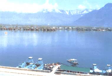
Photo: D.P. Zutshi
A. LOCATION
- Jammu and Kashmir, India.
- 34:18N, 74:91E; 1,583 m above sea level.
B. DESCRIPTION
-
Dal is a Himalayan urban lake which is mainly used for tourism. Fishery is of secondary importance. The lake comprises five basins and a myriad of inter- connecting channels. It is one of the most beautiful lakes of India and the second largest lake in the State of Jammu and Kashmir. The lake is surrounded by mountains on its three sides. A large number of gardens and orchards have been laid along the shores. Dal Lake is unique in having hundreds of house boats which afford an opportunity to tourists to reside on the lake in an atmosphere of peace and tranquility. The boats are served by Shikaras which more or less resemble the gondolas of Venice but are smaller in size and are tastefully decorated. Besides the Moghul monuments the campus of the University of Kashmir is also located along the shores of the lake. Overlooking the lake are two hillocks which house the famous temples of Shankaracharya and Hari Parbat. A perennial inflow channel enters the lake from the north and supplies about 80% of the water. Towards the southwest side an outflow channel drains the lake water into a tributary of the River Jhelum. Parallel to this exit is a stone-lined canal which connects the lake with the tributary. This channel is used for movement of boats in and out of the lake and prevents inundation of floating gardens during high floods.
The famous Moghul gardens around the lake have been laid during 16-17th century and their number was about five hundred but now only a few of these have survived. The origin of the lake has remained unresolved. It is believed by some geologists that the Dal Lake is the remnant of a Pleistocene oligotrophic lake which once covered the entire valley of Kashmir. There are other geologists who believe Dal to be a flood plain lake.
The lake water is being used for irrigation of vegetable fields which have grown in number and extent during recent years. The present maximum depth of the lake is 6 m (Nagin basin). Many aquatic plants growing in the lake are used as food, fodder and compost.
The water quality of Dal Lake has deteriorated considerably in the last two decades. Large peripheral areas have been reclaimed and converted into floating gardens. With the increase in the tourist influx a large number of residential buildings, restaurants and hotels have come up along the lake front. The number of house boats has also been increasing at an alarming rate. As a result of rapid and unplanned urbanization, large quantities of raw sewage are discharged in the lake water, which might pose health problems in the near future.
The main environmental issues are excessive weed growth, reduction in water clarity, enrichment of waters and high microbial activity. A Dal Development Project was formulated in 1978 and the State Government of Jammu and Kashmir adopted it with some modifications. The main thrust of the project is to improve the lake environment by using both physical and biological approaches. The work is in progress (Q).
C. PHYSICAL DIMENSIONS (Q)
| Surface area [km2] | 21*1 |
| Volume [km3] | 0.00983 |
| Maximum depth [m] | 6 |
| Mean depth [m] | 1.4*2 |
| Water level | Regulated |
| Normal range of annual water | |
| - level fluctuation [m] | 0.7 |
| Length of shoreline [km] | 15.5 |
| Catchment area [km2] | 316 |
*2 Nagin Basin.
D. PHYSIOGRAPHIC FEATURES (Q)
D1 GEOGRAPHICAL- Sketch map: Fig. ASI-38-01.
- Bathymetric map: Fig. ASI-38-02.
- Names of main islands: Sona Lank and Rupa Lank.
- Number of outflowing rivers and channels (name)
2 (Dal Gate and Nalla Amir Khan).
- Climatic data at Srinagar, 1977
| Jan | Feb | Mar | Apr | May | Jun | Jul | Aug | Sep | Oct | Nov | Dec | Ann. | |
|---|---|---|---|---|---|---|---|---|---|---|---|---|---|
| Mean temp. [deg C] | 0 | 3 | 9 | 14 | 18 | 22 | 24 | 23 | 20 | 14 | 3 | 5 | - |
| Precipitation [mm] | 70 | 75 | 92 | 90 | 60 | 36 | 55 | 62 | 40 | 26 | 11 | 38 | 655 |
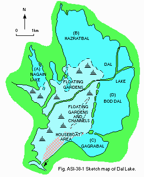
Sketch map.
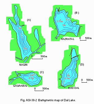
Bathymetric map.
- Water temperature [deg C]
| Hazratbal, 1983-1984 | ||||||||||||
| Depth [m] | Jan | Feb | Mar | Apr | May | Jun | Jul | Aug | Sep | Oct | Nov | Dec |
|---|---|---|---|---|---|---|---|---|---|---|---|---|
| 0 | 3 | 6 | 19 | 21 | 23 | 26 | 25 | 24 | 21 | 15 | 9 | 7 |
- Freezing period: January (only during severe winters).
- Mixing type: Polymictic.
- Notes on water mixing and thermocline formation@
Thermocline has been observed in Nagin basin.
E. LAKE WATER QUALITY (Q)
E1 TRANSPARENCY [m]| Hazratbal, 1983-1984 | ||||||||||||
| Depth [m] | Jan | Feb | Mar | Apr | May | Jun | Jul | Aug | Sep | Oct | Nov | Dec |
|---|---|---|---|---|---|---|---|---|---|---|---|---|
| 0.89 | 0.95 | 0.53 | 0.95 | 1.8 | 1.9 | 1.95 | 1.5 | 1.3 | 1.1 | 1.0 | 0.98 | |
| Hazratbal, 1983-1984 | ||||||||||||
| Depth [m] | Jan | Feb | Mar | Apr | May | Jun | Jul | Aug | Sep | Oct | Nov | Dec |
|---|---|---|---|---|---|---|---|---|---|---|---|---|
| 0 | 9.8 | 8.0 | 8.4 | 7.3 | 8.2 | 7.3 | 8.4 | 7.8 | 7.2 | 8.6 | 7.7 | 9.4 |
| Hazratbal, 1983-1984 | ||||||||||||
| Depth [m] | Jan | Feb | Mar | Apr | May | Jun | Jul | Aug | Sep | Oct | Nov | Dec |
|---|---|---|---|---|---|---|---|---|---|---|---|---|
| 0 | 4.4 | 7.8 | 3.6 | 4.0 | 5.6 | 6.4 | 4.8 | 1.4 | 9.6 | 12.3 | 10.2 | - |
-
Determined by KMnO4 method.
| Hazratbal, 1983-1984 | ||||||||||||
| Depth [m] | Jan | Feb | Mar | Apr | May | Jun | Jul | Aug | Sep | Oct | Nov | Dec |
|---|---|---|---|---|---|---|---|---|---|---|---|---|
| 0 | 4.7 | 0.9 | 0.52 | 0.43 | 1.48 | 4.2 | 5.0 | 2.3 | 1.5 | 2.0 | 2.0 | 0.28 |
- NO3-N [micro l-1]
| Hazratbal, 1983-1984 | ||||||||||||
| Depth [m] | Jan | Feb | Mar | Apr | May | Jun | Jul | Aug | Sep | Oct | Nov | Dec |
|---|---|---|---|---|---|---|---|---|---|---|---|---|
| 0 | 175 | 73 | 73 | 80 | 380 | 22 | 1315 | 95 | 94 | 88 | 219 | 285 |
- Total-P [micro l-1]
| Hazratbal, 1983-1984 | ||||||||||||
| Depth [m] | Jan | Feb | Mar | Apr | May | Jun | Jul | Aug | Sep | Oct | Nov | Dec |
|---|---|---|---|---|---|---|---|---|---|---|---|---|
| 0 | 104 | 69 | 81 | 46 | 138 | 35 | 577 | 138 | 69 | 58 | 162 | 46 |
| Hazratbal | |||
| 1965-1966 | 1980-1981 | 1983-1984 | |
|---|---|---|---|
| > pH | 7.9 | 8.6 | 8.8 |
| > PO4-P [micro l-1] | 20 | 92.6 | 115 |
| > NO3-N [micro l-1] | 105 | 556 | 780 |
| > NH4-N [micro l-1] | 250 | 730 | 850 |
F. BIOLOGICAL FEATURES (Q)
F1 FLORA- Emerged macrophytes: Typha angustifolia, Phragmites australis.
- Floating macrophytes
Salvinia natans, Hydrocharis dubia, Nymphoides peltata, Nymphaea sp., Nelumbo nucifela, Potamogeton natans. - Submerged macrophytes
Myriophyllum spicatum, Ceratophyllum demersum, Potamogeton crispus, P. lucens. - Phytoplankton
Navicula radiosa, Nitzschia accicularis, Fragilaria crotonensis, Diatoma elongatum, Scenedesmus bijuga, Pediastrum duplex, Tetraedron minimum, Microcystis aeruginosa, Merismopedia elegans.
- Zooplankton
Keratella cochlearis, K. serrulata, Polyarthra vulgaris, Brachionus plicatilis, Monostyla bulla, Alona monocantha, Cyclops ladakanus, Mesocyclops leukarti. - Benthos: Chironomus sp., Tubifex sp.
- Fish
Cyprinus carpio specularis*, C. carpio communis, Schizothorax niger, S. esocinus, S. curviformis, Crossochelius latius. * Economically important. - Supplementary notes on the biota
Cyprinus which was introduced in the lake during early sixties has become dominant and the indigenous species Schizothorax is gradually declining in number.
| Hazratbal, 1981 | |||||||||||
| Jan | Feb | Mar | Apr | May | Jun | Jul | Aug | Sep | Oct | Nov | Dec |
|---|---|---|---|---|---|---|---|---|---|---|---|
| - | - | - | - | 22.2 | 89.8 | 253.4 | 194.2 | 145.4 | 57.4 | - | - |
| Nagin, 1981 | |||||||||||
| Jan | Feb | Mar | Apr | May | Jun | Jul | Aug | Sep | Oct | Nov | Dec |
|---|---|---|---|---|---|---|---|---|---|---|---|
| - | - | - | - | 262.8 | 593.4 | 281.4 | 348.2 | 370.2 | 393.0 | - | - |
| Coverage | Organic matter production | |||
|---|---|---|---|---|
| Macrophyte | [ha] | [%] | [g m-2 day-1] | [t ha-1 yr-1] |
| Helophytes | 50 | 5 | 10.5-15.0 | 27.6 |
| Floating forms | 280 | 25-30 | 1.24-5.4 | 8.81 |
| Submerged | 680 | 55-65 | 0.77-2.4 | 4.62 |
-
Reduction in the number of Chara species since 1934.
Increase in the area covered by Salvinia since 1937.
Tendency to develop monospecific communities of submerged macrophytes, e.g.
Ceratophyllum and Myriophyllum.
G. SOCIO-ECONOMIC CONDITIONS (Q)
G1 LAND USE IN THE CATCHMENT AREA| 1985 | ||
| Area [km2] | [%] | |
|---|---|---|
| Natural landscape | ||
| - Woody vegetation | 103.00 | 37.4 |
| - Scrub | 36.26 | 13.2 |
| Agricultural land | ||
| - Crop field | 66.52 | 24.2 |
| - Pasture land | 31.25 | 11.4 |
| Residential area | 31.89 | 11.6 |
| Horticulture | 6.28 | 2.3 |
| Total | 275.20 | 100 |
- Main types of woody vegetation
Melia, Ailanthus, Robinia, Daphne, Celtis, Rosa, Ephedra. - Types of the other important vegetation
Introduced trees (Pinus roxburghii, P. halepensis, P. gerardiana, Cupressus torrulosa, C. arizonica). - Main kinds of crops: Rice, wheat, brassica.
- Levels of fertilizer application on crop fields: Moderate.
- Trends of change in land use
Agricultural land being converted into settlement area. Construction of residential and commercial buildings. Some crop land being brought under horticulture.
| 1977 | |||
| Population | Population density [km-2] | Major cities (population) | |
|---|---|---|---|
| Urban | 137,000 | ||
| Rural | 54,000 | 604 | |
| Total | 191,000 | ||
H. LAKE UTILIZATION (Q)
H1 LAKE UTILIZATION-
Source of water, sightseeing and tourism, recreation (swimming), fisheries and
harvesting of food and fodder plants.
I. DETERIORATION OF LAKE ENVIRONMENTS AND HAZARDS (Q)
I1 ENHANCED SILTATION- Extent of damage: Serious.
- Supplementary notes
The total volume of settled silt deposited in Dal Lake in 1976 through inflow Channel Telbal was 36,200 m3. This represents an area of 3.6 ha with a depth of 1 m.
- Nuisance caused by eutrophication: Excessive weed growth.
- Nitrogen and phosphorus loadings to the lake [t yr-1]
| 1977 | |||||
| Sources | Industrial | Domestic | Agricultural | Natural | Total |
|---|---|---|---|---|---|
| T-N | 0 | 359 | 275 | 0 | 634 |
| T-P | 0 | 39.9 | 6.4 | 0 | 46.3 |
- Supplementary notes
Over the years as a result of urbanization and tourist influx the lake is getting rapidly eutrophied. The measures that are being implemented for rehabilitation include mechanical harvesting of weeds, removal of barricades to facilitate water circulation, moratorium on house boat construction and control on unlawful encroachments.
J. WASTEWATER TREATMENTS (Q)
J1 GENERATION OF POLLUTANTS IN THE CATCHMENT AREA-
e) Severe pollution with no wastewater treatment. Human wastes and kitchen refuse are released from house boats into the lake water without any treatment.
| [%] | |
|---|---|
| Non-point Sources | 55 |
| Point sources | 25 |
| House boats and hotels | 20 |
| Total | 100 |
K. IMPROVEMENT WORKS IN THE LAKE (Q)
Kl RESTORATION-
Construction of siltation tank, mechanical deweeding, regrouping of house
boats, deepening of outflow channel, etc.; part of the work is in progress.
Removal of bunds and barricades including some floating gardens; part of the
work has been already done.
K3 OTHERS
-
Moratorium on new construction works close to lake front, no new house boats
to be added to the lake, and shifting of population from the lake front.
L. DEVELOPMENT PLANS (Q)
-
Reafforestation of catchment area to reduce movement of silt and erosion,
control of grazing, and construction of bunds and pedestrian mall to stop
further ingression on lake area (some work has already been done). These
plans are to be executed in the near future. They have already been
recommended for implementation. There is plan for sewage treatment also.
M. LEGISLATIVE AND INSTITUTIONAL MEASURES FOR UPGRADING LAKE ENVIRONMENTS (Q)
M1 NATIONAL AND LOCAL LAWS CONCERNED- Names of the laws (the year of legislation)
- The Environment Protection Act (1986)
- Responsible authorities
- The Government of India
- Main items of control
Planning execution of a nation-wide programme for the prevention, control and abatement of environmental pollution. Laying down standards for the quality of environment and its various aspects. Examination of such manufacturing processes, materials and substances which are likely to cause environmental pollution. - Supplementary notes
Inspection of any premise, equipment,machinery, manufacturing or other processes, materials or substances and giving, by order, of such directions to such authorities, officers or persons as it may consider necessary to take steps for the prevention, control and abatement of environmental pollution.
- Urban Environment Engineering Department, Jammu and Kashmir Government
- Department of Environment, Ecology, Science and Technology, Jammu and Kashmir Governments
- Centre of Research for Development, University of Kashmir
N. SOURCES OF DATA
- Questionnaire filled by Prof. D. P. Zutshi, Centre of Research for Development, University of Kashmir, Srinagar, India.
- Vass, J. K. & Zutshi, D. P. (1979) J. Inld, Fish. Soc., 11: 12-21.
- Zutshi, D. P. & Vass, K. K. (1978) Indian J. Ecol., 5: 90-97.
- Zutshi, D. P. & Vass, K. K. (1982) Proc. Indian Natn. Sci. Acad. B., 48: 234-241.
- Vass, K. K. & Zutshi, D. P.(1983) Arch. Hydrobiol., 97: 39-59.
- Zutshi, D. P. (1987) Impact of human activities on the evolution of Dal Lake environment. In: Pangtey, Y. P. S. and Joshi, S. C. (eds.) Western Himalaya: Environment, Problems and Development, pp. 565-577. Nainital, India.
- Enex (1978) Study of the Pollution of Dal Lake, Srinagar, Kashmir, India. A report prepared for the Common wealth Fund for Technical Cooperation by Enex of New Zealand Inc.
- Urfi, S. (1985) Physical, Chemical and Trace Metal Analysis of Dal Lake. M. Phil dissertation of Kashmir University. 87 pp. (unpublished).
