
KASUMIGAURA (LAKE KASUMIGAURA)
A view at the lake center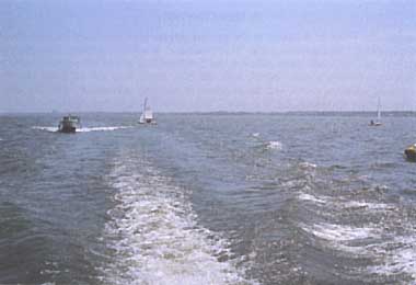
Photo: A. Kurata
A. LOCATION
- Ibaraki Prefecture, Japan.
- 35:52-36:09N, 140:13-140:38E; 0.16 m above sea level.
B. DESCRIPTION
- >Kasumi-ga-ura (lake of Kasumi) is the second largest
lake of Japan located about 60 km northeast of Tokyo. The general name
"Kasumigaura" is used to include altogether the main lake (Nishiura), two
attached lakes (Kitaura and Sotonasakaura) and the rivers connecting them.
These lakes once formed a deep marine bay, but have since been cut off
from the sea by the sedimentation of adjacent rivers and the progress of
tectonic subsidence since the late tertiary period. The present maximum
depth is only 7 m in both Nishiura and Kitaura.
The lake water has long been used for irrigation of paddy fields in the surrounding alluvial plain and upland fields on diluvial terraces covered by thick deposits of volcanic ash. With the increase in population and industrialization around the lake's drainage basin in recent years, however, the need for rational and effective use of its water resource of some 850 million tons became pressing. The Kasumigaura Development Project thus started in 1971 for water use and flood control, and was followed by another program for improving river head areas of the lake. These enabled supplies of the lake water to the Kashima Coastal Industrial Zone, the Tokyo metropolitan area, and other new needs.
Since shallow lakes are liable to rapid eutrophication, Kasumigaura is also suffering from severe blooms of Microcystis every summer which have seriously damaged carp culture in the lake and caused foul smelling of tap water annually. Ibaraki Prefectural Government legislated the Eutrophication Prevention Act in 1981, and is making efforts to check further progress of eutrophication by reducing nitrogen and phosphorus loadings of the lake. Kasumigaura was appointed to a "designated lake" in December 1985 based on the Law Concerning Special Measures for Preserving Lake Water Quality, and measures for water quality improvement have been stepped up (Q).
C. PHYSICAL DIMENSIONS
| Surface area [km2] | 220 |
| Volume [km3] | 0.848 |
| Maximum depth [m] | 7 |
| Mean depth [m] | 4 |
| Water level | Regulated |
| Normal range of annual water | |
| - level fluctuation [m] | 0.2-0.3 |
| Length of shoreline [km] | 252 |
| Residence time [yr] | 0.6 |
| Catchment area [km2] | 1,915 |
D. PHYSIOGRAPHIC FEATURES
D1 GEOGRAPHICAL- Bathymetric map: Fig. ASI-35-01.
- Number of outflowing rivers and channels (name): 1 (Hitachitone R.).
- Climatic data at Tsuchiura, 1973-1982
| Jan | Feb | Mar | Apr | May | Jun | Jul | Aug | Sep | Oct | Nov | Dec | Ann. | |
|---|---|---|---|---|---|---|---|---|---|---|---|---|---|
| Mean temp. [deg C] | 3.2 | 4.1 | 7.1 | 12.9 | 17.4 | 20.7 | 23.9 | 25.5 | 21.9 | 16.6 | 11.1 | 5.6 | 14.1 |
| Precipitation [mm] | 36 | 45 | 80 | 108 | 129 | 127 | 118 | 101 | 168 | 154 | 80 | 27 | 1,172 |
- Number of hours of bright sunshine (Tsuchiura, 1979-1982): 2308 hr yr-1.
- Solar radiation (Tateno, 1974-1980): 13.0 MJ m-2 day-1.
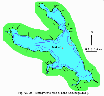
Bathymetric map (1).
- Water temperature [deg C](Q)
| Station 1, 1986 | ||||||||||||
| Depth [m] | Jan | Feb | Mar | Apr | May | Jun | Jul | Aug | Sep | Oct | Nov | Dec |
|---|---|---|---|---|---|---|---|---|---|---|---|---|
| S* | 5.0 | 3.0 | 4.0 | 13.0 | 17.0 | 21.0 | 21.0 | 27.0 | 27.0 | 21.0 | 14.0 | 9.0 |
- Freezing period: None.
- Mixing type: Monomictic.
- Notes on water mixing and thermocline formation
The thermocline formation is none.
E. LAKE WATER QUALITY
E1 TRANSPARENCY [m](Q)| Station 1, 1986 | ||||||||||||
| Depth [m] | Jan | Feb | Mar | Apr | May | Jun | Jul | Aug | Sep | Oct | Nov | Dec |
|---|---|---|---|---|---|---|---|---|---|---|---|---|
| 1.1 | 2.0 | 1.2 | 0.9 | 0.8 | 0.9 | 0.9 | 0.7 | 0.6 | 0.3 | 0.6 | 0.6 | |
| Station 1, 1986 | ||||||||||||
| Depth [m] | Jan | Feb | Mar | Apr | May | Jun | Jul | Aug | Sep | Oct | Nov | Dec |
|---|---|---|---|---|---|---|---|---|---|---|---|---|
| S* | 7.6 | 7.5 | 7.5 | 7.8 | 8.3 | 8.5 | 8.1 | 8.9 | 9.2 | 8.6 | 7.8 | 7.9 |
| Station 1, 1986 | ||||||||||||
| Depth [m] | Jan | Feb | Mar | Apr | May | Jun | Jul | Aug | Sep | Oct | Nov | Dec |
|---|---|---|---|---|---|---|---|---|---|---|---|---|
| S* | 4 | 3 | 5 | 12 | 14 | 9 | 13 | 15 | 14 | 28 | 22 | 21 |
| Station 1, 1986 | ||||||||||||
| Depth [m] | Jan | Feb | Mar | Apr | May | Jun | Jul | Aug | Sep | Oct | Nov | Dec |
|---|---|---|---|---|---|---|---|---|---|---|---|---|
| S* | 10.0 | 11.0 | 12.0 | 9.1 | 9.8 | 9.5 | 7.4 | 8.5 | 7.9 | 9.0 | 10.0 | 10.0 |
| Station 1, 1986 | ||||||||||||
| Depth [m] | Jan | Feb | Mar | Apr | May | Jun | Jul | Aug | Sep | Oct | Nov | Dec |
|---|---|---|---|---|---|---|---|---|---|---|---|---|
| S* | 6.2 | 5.8 | 6.2 | 6.5 | 7.9 | 7.2 | 7.4 | 10.0 | 12.0 | 11.0 | 9.0 | 8.7 |
| Station 1, 1986 | ||||||||||||
| Depth [m] | Jan | Feb | Mar | Apr | May | Jun | Jul | Aug | Sep | Oct | Nov | Dec |
|---|---|---|---|---|---|---|---|---|---|---|---|---|
| S* | 15.0 | 8.0 | 28.0 | 36.0 | 64.0 | 29.0 | 53.0 | 75.0 | 65.0 | 87.0 | 60.0 | 42.0 |
- Total-N [mg l-1]
| Station 1, 1986 | ||||||||||||
| Depth [m] | Jan | Feb | Mar | Apr | May | Jun | Jul | Aug | Sep | Oct | Nov | Dec |
|---|---|---|---|---|---|---|---|---|---|---|---|---|
| S* | 1.1 | 1.1 | 1.0 | 0.72 | 0.87 | 0.95 | 0.88 | 1.4 | 1.4 | 1.4 | 1.5 | 1.4 |
- Total-P [mg l-1]
| Station 1, 1986 | ||||||||||||
| Depth [m] | Jan | Feb | Mar | Apr | May | Jun | Jul | Aug | Sep | Oct | Nov | Dec |
|---|---|---|---|---|---|---|---|---|---|---|---|---|
| S* | 0.02 | 0.02 | 0.02 | 0.05 | 0.06 | 0.05 | 0.05 | 0.07 | 0.1 | 0.1 | 0.03 | 0.04 |
| Station 1, 1986 | ||||||||||||
| Depth [m] | Jan | Feb | Mar | Apr | May | Jun | Jul | Aug | Sep | Oct | Nov | Dec |
|---|---|---|---|---|---|---|---|---|---|---|---|---|
| S* | 46.0 | 42.0 | 42.0 | 50.0 | 47.0 | 47.0 | 48.0 | 24.0 | 37.0 | 40.0 | 41.0 | 45.0 |
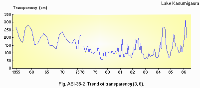
Trend of transparency (3, 6).

Trend of total COD (6).
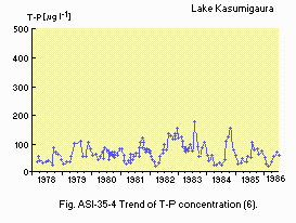
Trend of T-P concentration (6).
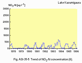
Trend of NO3-N concentration (6).
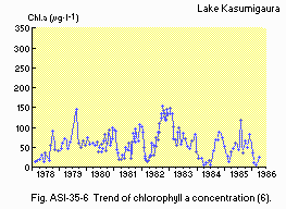
Trend of chlorophyll a concentration (6).
F. BIOLOGICAL FEATURES
F1 FLORA (4)- Emerged macrophytes
- Floating macrophytes
- Submerged macrophytes
- Phytoplankton
Phragmites communis, Typha latifolia, Zizania latifolia, Monochoria korsakowii.
Nymphoides indica, N. peltata, Hydrocharis dubia, Spirodela polyrhiza.
Potamogeton perfoliatus, P. malaianus, P. maackianus, Vallisneria asiatica.
Melosira spp., Microcystis aeruginosa, Anabaena flos-aquae, A. spiroides, Synedra rumpens, Hormidium sp.
- Zooplankton
- Benthos
- Fish
Filinia longiseta, Trichocera birostris, Bosmina fatalis, Vorticella spp.
Chironomus plumosus, Tokunagayusurika akamusi, Macrobrachium nipponensis, Neomysis intermedia, Tubifex sp., Limnodrilus sp.
Cyprinus carpio, Mugil cephalus, Hypomesus olidus, Anguilla japonica, Carassius gibelio.
| Station 1, January-December | ||||
| 1977*1 | 1978*1 | 1979*1 | 1982*2 | |
|---|---|---|---|---|
| Gross production | 470 | 570 | 990 | 740 |
| Respiration | (140)*3 | (170) | (300) | 220 |
| Net production | (330) | (400) | (690) | 520 |
- Annual fish catch [metric tons]
1980-1985: 8,745.
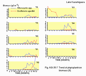
Trend of phytoplankton biomass (9).
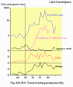
Trend of fishery production (10).
G. SOCIO-ECONOMIC CONDITIONS
G1 LAND USE IN THE CATCHMENT AREA (Q)| 1985 | ||
| Area[km2] | [%] | |
|---|---|---|
| Natural landscape | ||
| - Highlands | 861 | 45.0 |
| Agricultural land | ||
| - Paddy field | 466 | 24.3 |
| - Farm | 367 | 19.2 |
| Residential area | 221 | 11.5 |
| Total | 1,915 | 100.0 |
- Types of important forest (5)
- Types of important herbaceous vegetation: Grassland and swamp (5).
- Main kinds of crops
- Levels of fertilizer application on crop fields: Heavy to moderate.
- Trends of change in land use
Deciduous broad leaf forest (Quercus serrata, Q. acutissima, Castanea crenata, Carpinus spp.); pine forest (Pinus densiflora); evergreen broad leaf forest (Castanopsis cuspidata, Quercus spp.); evergreen conifer plantation (Pinus densiflora, P. thunbergii, Cryptomeria japonica, Chamaecyparis obtusa).
Rice, cucumber, eggplant, peanut, watermelon, melon, Chinese cabbage, pumpkin, tomato, sweet potato, lotus rhizome.
Wide area of watershed forest has been turned into housing lots due to the damage on pine forest by pine wilting disease and the progress of urbanization.
| 1985 | ||||
| Gross product during the year [mill. yen] | No. of persons engaged | No. of establishments | Main products or major industries | |
|---|---|---|---|---|
| Primary industry | - | 109,000 | N.A. | |
| - Agriculture | 190,400 | 379,000 | 76,966 | 1) |
| - Animal husbandry | 94,800 | - | - | 2) |
| - Fisheries | 5,100 | - | 1,112 | |
| Secondary industry | - | 169,700 | ||
| - Manufacturing | 1,932,300 | 105,000 | 3,459 | 3) |
| Tertiary industry | N.A. | 262,000 | - | 4) |
- 1) Rice, vegetables and fruits.
2) Smelt, white bait, carp and freshwater pearl.
3) Machinery, electric wire, brewing, building stone, soy, etc.
4) Construction.
| 1985 | |||
| Population | Population density [km-2] | Major cities (population) | |
|---|---|---|---|
| Total | 848,000 | 443 | Tsuchiura, Tsukuba, Ishioka, Ushiku, Ryugasaki, Shimodate |
H. LAKE UTILIZATION
H1 LAKE UTILIZATION (Q)- Source of water, fisheries, navigation, tourism and recreation (sport-fishing,
yachting).
H2 THE LAKE AS WATER RESOURCE (Q)
| 1985 | |
| Use rate [m3 sec-1] | |
|---|---|
| Domestic | 1.86 |
| Irrigation | 47.96 |
| Industrial | 6.08 |
| Others | |
| - Fish culture | 0.16 |
I. DETERIORATION OF LAKE ENVIRONMENTS AND HAZARDS (Q)
I1 ENHANCED SILTATION- Extent of damage: None.
- Supplementary note
The sedimentation rate is estimated to be 1,000,000 [m3 yr-1]. The sediment has been dredged at a rate of 100,000 [m3 yr-1].
- Present status: None.
- Nuisance caused by eutrophication (Q)
- Nitrogen and phosphorus loadings to the lake [t yr-1](Q)
Unusual bloom of Microcystis. Disturbed filtration in cleaning bed. Foul smell of tap water. Harm on fishes (1973-1974), damage to fish culture (carp).
| 1981 | |||||
| Sources | Industrial | Domestic | Agricultural | Natural | Total |
|---|---|---|---|---|---|
| T-N | 219.0 | 1,299.4 | 2,098.8 | 631.5 | 4,248.7 |
| T-P | 120.5 | 124.1 | 164.3 | 47.5 | 456.4 |
- Supplementary notes
The Ibaraki Prefectural Ordinance for the Prevention of Eutrophication of Lake Kasumigaura was enacted in 1982. The Basic Plan for Prevention of Eutrophication was also prepared at the same time to help implementation of the ordinance. A series of legislative efforts including ban on the use and selling of phosphate-containing synthetic detergents, control of nitrogen and phosphorus contents in effluent of factories, etc. has been carried out for decreasing nitrogen and phosphorus loads.
- Extent of damage: None.
J. WASTEWATER TREATMENTS (Q)
J1 GENERATION OF POLLUTANTS IN THE CATCHMENT AREA- d) Measurable pollution with limited wastewater treatment.
| 1985 | ||
| Source | COD [t day-1] | ratio [%] |
|---|---|---|
| Non-point sources | 23.81 | 75.0 |
| (agricultural, natural and dispersed settlements) | ||
| Point sources | ||
| - Public sewerage | 0.16 | 0.5 |
| - Industrial | 1.56 | 4.9 |
| - Animal husbandry | 3.81 | 12.0 |
| - Fish culture | 2.40 | 7.6 |
| Total | 31.74 | 100 |
- Percentage of population in the catchment area provided with public
- Municipal wastewater treatment systems
sewerage: 18%.
No. of tertiary treatment systems: 2 (activated sludge). No. of secondary treatment systems: 3 (activated sludge). Rate of treatment: 23,000 m3 day-1.
K. IMPROVEMENT WORKS IN THE LAKE (Q)
Kl RESTORATION- Dredging work is being carried out in the lake (100,000 ton yr-1) and
at estuaries of main inflowing rivers.
K3 OTHERS
- Waters from Naka River and Tone River will be led into Lake Kasumigaura
for purifying lake water from 1993 onward.
L. DEVELOPMENT PLANS (Q, 3)
Tsukuba Research Complex has been developed within the lake's catchment area under the support by Japanese Government, Housing and Urban Development Corporation and etc. since 1963 to concentrate national experiment stations and research institutes in a metropolis. The area of the complex is 2,700 ha and the total cost of this plan is about 1,500 billion yen.M. LEGISLATIVE AND INSTITUTIONAL MEASURES FOR
UPGRADING LAKE ENVIRONMENTS(Q)
M1. NATIONAL AND LOCAL LAWS CONCERNED
*Names of the laws(the year of legislation)
(1) The Ibaraki Prefectural Eutrophication Prevention
Act (1981)
(2) Law Concerning Special Measures
for Improving Riverhead Areas (1973)
(3) Law Concerning Special Measured
for Preserving Lake Water Quality (1984)
* Responsible authorities
(1) Ibaraki Prefectural Government
(2) and (3) National Government
* Main items of control
(1) Water Quality (P, N)
(3) Water Quality (COD)
M2 INSTITUTIONAL MEASURES
(1) Kasumigaura Section, Bureau
of Environmental Protection, Ibaraki Prefectural Government, Mito (Established
in 1980)
(2) Lake Kasumigaura Work Office,
Ministry of Construction, Itako (established in 1967)
(3) The National Institute for
Environmental Studies, Tsukuba (established in 1974)
M3 RESEARCH INSTITUTES ENGAGED IN THE LAKE ENVIRONMENT
STUDIES
(1) The National Institute for
Environmental Studies
(2) Public Works Research Institute,
Ministry of Construction
(3) Tsukuba University
(4) Ibaraki University
N. SOURCES OF
DATA
*Printed in Japanese. The titles are tentatively
translated into English with the original titles in romanized Japanese
in parentheses.
** In Japanese with English summary.
(Q) Questionnaire filled by Ibaraki Prefectural Government.
(1) Japan Map Center (ed.) 1982
Maps of Japanese Lakes (Nihon no Kosho Zushu). Technical Data D1-No.221,
Geogr. Survey Inst., Ministry of Construction, Tsukuba.*
(2) Uchida, E., Asakura, T. & Kawamura, T. (ed.)
(1983) Handbook of Japanese Weather Vol.2 (Nihon Kisho Soran, Gekan). 1060
pp. Toyo Keizai Shinposha, Tokyo. *
(3) Ibaraki Prefectural Government (1979) Report
of Lake Survey (Kosho Chosa Hokokusho). 78pp, Mito. *
(4) Lake Kasumigaura Work Office, Ministry of Construction
(1980) Organisms in Lake Kasumigaura (Kasumigaura no Seibutsu). 174pp,
Itako.*
(5) Environment Agency (1981) The
2nd National Survey on the Natural Environment (Vegetation); Actual Vegetation
Map, Ibaraki (Dai-2-Kai Shizen-Kankyo Hozen Kiso-chosa (Shokusei chosa);
Genzon Shokusei-zu, Ibaraki-ken). Japan Wildlife Institut, Tokyo. *
(6) Aizaki, M., Fukushima, T., Ebise, S., Hozomi,
M., Iwakuma, T., Hanazato, T., Takamura, N., Nohara, S., Otski, A., Kawai,
M., Shiraishi, H. & Nojiri, Y. (1988) Limnological Data in Lake Kasumigaura
(Kokuritsu Kogai Kenkyusho Chosa Shiryo). B-33: 1-18. *
(7) Takamura. N., Iwakuma, T. & Yasuno, M. (1984)
The biomass and production of phytoplankton in Lake Kasumigaura during
1981-83. Res. Rep. Natl. Inst. Environ. Stud. Jun., 51: 11-56.**
(8) Statistics and Information Department, Economic
Affairs Bureau, Japanese Ministry of Agriculture and Forestry (1986)
Annual Report on Agriculture, Forestry and Fisheries Statistics (Norin
Suisan Tokei Nenpo). Tokyo.*
(9) Takamura, N., Iwakura, T. & Yasuno, M. (1987)
Primary production in Lake Kasumigaura, 1981-1985. Jap J. Limnol., 48 (Special
Issue): S13-38.
(10) Kasuga, S. (1987) Water Quality management through
biomanipulation (Kosho no Dobutsuso-Kanri ni yoru Suishitsu-Hozen). Journal
of Environmental Pollution Control (Kogai to Taisaku),23:857-863.*
