SHUMARINAI-KO (LAKE SHUMARINAI)
A lake view from the eastern hill-side
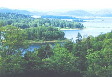
Photo: A. Kurata
A. LOCATION
- Hokkaido, Japan.
- 44:20N, 142:13E; 285 m above sea level.
B. DESCRIPTION
Lake Shumarinai is the only man-made lake in Hokkaido, Japan. It was formed by the construction of Uryu Dam in the upstream of Uryu River to serve as a reservoir for hydroelectric power generation. The lake is called generally Shumarinai-ko, but it is also called formally the First Uryu Reservoir. The dam construction was initiated in 1937 and completed in 1943 by Hokkaido Electric Company. The lake now supplies irrigation water at an average rate of 9.73 m3 sec-1 only for summer season from May to August together with hydroelectric power. It also plays an important role to prevent flood in the downstream area at the time of spring thaw.
The lake is located about 20 km west of Nayoro City. With 13 islands, the lake is irregularly arborescent in shape. The area surrounding the lake is designated as a prefectural natural park for preserving wildlife and other natural resources. Not only hunting and capture of animals but also deforestation are strictly prohibited.
The climate of Lake Shumarinai is characterized by severe, long winter and dry, short summer. The lake freezes regularly from late autumn to late spring. Horokanai Town located on the shore of this lake is so famous as one of the coldest places in Japan; an air temperature of -41.2deg C was recorded in the town in 1978.
The catchment area of reservoir (312.1 km2) is sparsely populated and largely covered by dense forest, containing only a small part of agricultural land. The water has remained oligotrophic, chlorophyll and total phosphorus concentration being very low (Q, 1).
C. PHYSICAL DIMENSIONS (Q)
| Surface area [km2] | 24 |
| Volume [km3] | 0.2447 |
| Water level | Regulated |
| Normal range of annual water |
| - level fluctuation [m] | 11 |
| Length of shoreline [km] | 83.5 |
| Residence time [yr] | 68 |
| Catchment area [km2] | 312 |
D. PHYSIOGRAPHIC FEATURES (Q)
D1 GEOGRAPHICAL
- Sketch map: Fig. ASI-33-01.
- Names of main islands: Fujiwara-jima and Kitao-shima.
- Number of outflowing rivers and channels (names): 1 (Uryu R.).
D2 CLIMATIC
- Climatic data at the lake side, 1975-1976
| Jan | Feb | Mar | Apr | May | Jun | Jul | Aug | Sep | Oct | Nov | Dec | Ann. |
| Mean temp. [deg C] | -11.3 | -12.0 | -5.8 | 2.3 | 8.8 | 14.9 | 18.7 | 18.3 | 14.1 | 7.5 | 0.1 | -6.2 | 4.1 |
| Precipitation [mm] | 80 | 45 | 63 | 69 | 70 | 84 | 83 | 197 | 152 | 169 | 134 | 82 | 1,228 |
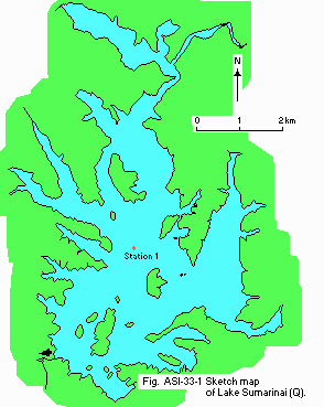
Fig. ASI-33-01
Sketch map (Q).
- Water temperature [deg C]
| Several stations, 1982 |
| Depth [m] | Jan | Feb | Mar | Apr | May | Jun | Jul | Aug | Sep | Oct | Nov | Dec |
| 0 | - | - | - | - | - | 16.3 | - | - | - | - | - | - |
| 5 | - | - | - | - | - | 14.9 | - | - | - | - | - | - |
| 30 | - | - | - | - | - | 6.5 | - | - | - | - | - | - |
- Freezing period: November-May.
E. LAKE WATER QUALITY (Q)
E1 TRANSPARENCY [m]
| Station 1, 1982 |
| Depth [m] | Jan | Feb | Mar | Apr | May | Jun | Jul | Aug | Sep | Oct | Nov | Dec |
| - | - | - | - | - | 5.0 | - | - | - | - | - | - |
E2 pH
| Station 1, 1982 |
| Depth [m] | Jan | Feb | Mar | Apr | May | Jun | Jul | Aug | Sep | Oct | Nov | Dec |
| 0 | - | - | - | - | - | 7.2 | - | - | - | - | - | - |
| 5 | - | - | - | - | - | 7.1 | - | - | - | - | - | - |
| 25 | - | - | - | - | - | 6.6 | - | - | - | - | - | - |
E3 SS [mg l-1]
| Station 1, 1982 |
| Depth [m] | Jan | Feb | Mar | Apr | May | Jun | Jul | Aug | Sep | Oct | Nov | Dec |
| 0 | - | - | - | - | - | 2 | - | - | - | - | - | - |
| 5 | - | - | - | - | - | 2 | - | - | - | - | - | - |
| 25 | - | - | - | - | - | 8 | - | - | - | - | - | - |
E4 DO [mg l-1]
| Station 1, 1982 |
| Depth [m] | Jan | Feb | Mar | Apr | May | Jun | Jul | Aug | Sep | Oct | Nov | Dec |
| 0 | - | - | - | - | - | 9.0 | - | - | - | - | - | - |
| 5 | - | - | - | - | - | 9.1 | - | - | - | - | - | - |
| 25 | - | - | - | - | - | 8.1 | - | - | - | - | - | - |
E5 COD [mg l-1]
Determined by KMnO4 method.
| Station 1, 1982 |
| Depth [m] | Jan | Feb | Mar | Apr | May | Jun | Jul | Aug | Sep | Oct | Nov | Dec |
| 0 | - | - | - | - | - | 1.6 | - | - | - | - | - | - |
| 5 | - | - | - | - | - | 1.7 | - | - | - | - | - | - |
| 25 | - | - | - | - | - | 1.8 | - | - | - | - | - | - |
E6 CHLOROPHYLL CONCENTRATION [micro l-1]
| Station 1, 1982 |
| Depth [m] | Jan | Feb | Mar | Apr | May | Jun | Jul | Aug | Sep | Oct | Nov | Dec |
| 0 | - | - | - | - | - | 1.32 | - | - | - | - | - | - |
| 5 | - | - | - | - | - | 1.02 | - | - | - | - | - | - |
| 25 | - | - | - | - | - | 0.72 | - | - | - | - | - | - |
E7 NITROGEN CONCENTRATION
| Station 1, 1982 |
| Depth [m] | Jan | Feb | Mar | Apr | May | Jun | Jul | Aug | Sep | Oct | Nov | Dec |
| 0 | - | - | - | - | - | 0.11 | - | - | - | - | - | - |
| 5 | - | - | - | - | - | 0.13 | - | - | - | - | - | - |
| 25 | - | - | - | - | - | 0.38 | - | - | - | - | - | - |
E8 PHOSPHORUS CONCENTRATION
| Station 1, 1982 |
| Depth [m] | Jan | Feb | Mar | Apr | May | Jun | Jul | Aug | Sep | Oct | Nov | Dec |
| 0 | - | - | - | - | - | 0.008 | - | - | - | - | - | - |
| 5 | - | - | - | - | - | 0.013 | - | - | - | - | - | - |
| 25 | - | - | - | - | - | 0.007 | - | - | - | - | - | - |
F. BIOLOGICAL FEATURES (1)
F2 FAUNA
- Fish
Oncorhynchus masou, Tribolodon hakonensis, Cyprinus carpio, Hypomesus transpacificus nipponensis, Salvelinus leucomaenis, Hucho Perryi, Gasterosteus aculeatus aculeatus.
F5 FISHERY PRODUCTS
- Annual fish catch [metric tons]
1982: 17.3.
G. SOCIO-ECONOMIC CONDITIONS (1)
G1 LAND USE IN THE CATCHMENT AREA
| Area[km2] | [%] |
| Natural landscape |
| - Woody vegetation | 225.58 | 72.3 |
| Agricultural land | 4.80 | 1.53 |
| Residential area | 0.13 | 0.04 |
| Others | 81.57 | 26.13 |
| Total | 312.08 | 100 |
- Main types of woody vegetation
Evergreen forest (Abies sachalinensis); deciduous forest (Ulmus davidiana, Sorbus commixta, Acer mono, Fraxinus mandshurica, Alnus maximowiczii, Morus bombycis).
G2 INDUSTRIES IN THE CATCHMENT AREA AND THE LAKE
- Numbers of domestic animals in the catchment area: Cattle 438.
G3 POPULATION IN THE CATCHMENT AREA
| 1981 |
| Population | Population density [km-2] | Major cities (population) |
| Total | 152 | 0.5 | None |
H. LAKE UTILIZATION
H1 LAKE UTILIZATION (1)
Source of water, fisheries and sight-seeing.
H2 THE LAKE AS WATER RESOURCE (2)
| 1984 |
| Use rate [m3 sec-1] |
| Irrigation | 9.73 | (May-August) |
| Power plant | 12.0 (0-44.2) |
I. DETERIORATION OF LAKE ENVIRONMENTS AND HAZARDS
I1 ENHANCED SILTATION: No information.
I2 TOXIC CONTAMINATION (1): None.
I3 EUTROPHICATION (1): None.
I4 ACIDIFICATION (1): None.
J. WASTEWATER TREATMENTS (1)
J1 GENERATION OF POLLUTANTS IN THE CATCHMENT AREA
a) Pristine lake environments.
J3 SANITARY FACILITIES AND SEWERAGE
- Percentage of rural population with adequate sanitary facilities (on-site
treatment systems): 100%.
M. LEGISLATIVE AND INSTITUTIONAL MEASURES FOR UPGRADING LAKE ENVIRONMENTS
M1 NATIONAL AND LOCAL LAWS CONCERNED
For national laws see "Biwa-ko".
N. SOURCES OF DATA
- Questionnaire filled by the Prefectural Government of Hokkaido.
- The editor's observation.
- The First Uryu Dam Control Office of Hokkaido Electric Co., Ltd. Personal communication.

