
KIZAKI-KO (LAKE KIZAKI)
Yachting on the lake in summer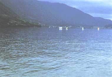
Photo: A. Kurata
A. LOCATION
- Nagano Prefecture, Japan.
- 36:33N, 137:50E; 764 m above sea level.
B. DESCRIPTION
-
The so-called "Nishina Three Lakes", L. Aoki, L. Nakatsuna and L. Kizaki, are a chain of tectonic lakes about 30,000 years old. They are situated at the eastern foot of the Japanese Northern Alps along the remarkable tectonic zone or Fossa Magna which traverses the main island (Honshu) of Japan. L. Aoki (maximum depth 58 m) is oligotrophic, L. Nakatsuna (maximum depth 12 m) is eutrophic, and L. Kizaki (maximum depth 29.5 m) is mesotrophic, although these lakes are arranged linearly from north to south along the same water system. The trophic level of the water is apparently inversely correlated with depth. Since such nutritional dynamics lend themselves to comparative limnology, many studies have been carried out on the Nishina Three Lakes since the first voluminous work by A. Tanaka, "Studies on the Lakes of the Japanese Northern Alps (1930)".
The water level of L. Aoki in winter has been lowered by about 20 m since 1954, owing to the use of its water for power generation. Provision was also made to introduce cold water from a neighboring river running down from the Japanese Alps, thus radically changing the aquatic environment of L. Aoki. The water level of L. Kizaki also becomes lower by about 3 m in winter, and is recovered in spring by channeling water from L. Aoki. The transparency in L. Kizaki averaged about 5 m until 1950, but decreased to approximately 3 m since 1970. From the end of the 1970's, Anabaena has bloomed annually in July- August, and the coloration of surface water has also become frequent due to the increase of microorganisms which graze upon Anabaena. These evidences suggest that the trophic level of this lake has recently changed from mesotrophic to eutrophic.
C. PHYSICAL DIMENSIONS (Q)
| Surface area [km2] | 1 |
| Volume [km3] | 0.025 |
| Maximum depth [m] | 29.5 |
| Mean depth [m] | 17.9 |
| Water level | Regulated |
| Normal range of annual water | |
| - level fluctuation [m] | 3 |
| Length of shoreline [km] | 7.0 |
| Residence time [yr] | 0.5 |
| Catchment area [km2] | 22 |
D. PHYSIOGRAPHIC FEATURES
D1 GEOGRAPHICAL- Bathymetric map: Fig. ASI-32-01.
- Number of outflowing rivers and channels (name): 1 (Nougu R.).
- Climatic data at Aoki-ko, 1972-1980 (Q)
| Jan | Feb | Mar | Apr | May | Jun | Jul | Aug | Sep | Oct | Nov | Dec | Ann. | |
|---|---|---|---|---|---|---|---|---|---|---|---|---|---|
| Mean temp. [deg C] | -3.5 | -3.4 | 0.2 | 7.1 | 13.0 | 17.1 | 21.0 | 21.5 | 17.1 | 11.0 | 4.8 | -0.5 | 8.8 |
| Precipitation [mm] | 184 | 171 | 148 | 160 | 136 | 218 | 180 | 179 | 164 | 112 | 144 | 157 | 1,953 |
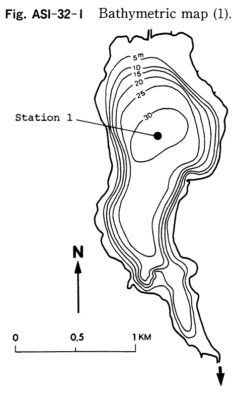
Bathymetric map (1).
- Water temperature [deg C](5)
| Station 1, 1985 | ||||||||||||
| Depth [m] | Jan | Feb | Mar | Apr | May | Jun | Jul | Aug | Sep | Oct | Nov | Dec |
|---|---|---|---|---|---|---|---|---|---|---|---|---|
| 0.5 | - | - | - | 11.5 | 14.4 | 19.7 | 20.7 | 28.0 | 21.1 | 16.1 | 9.9 | 5.9 |
| 29 | - | - | - | 6.8 | 5.4 | 5.7 | 5.8 | 5.8 | 5.9 | 5.9 | 5.9 | 5.7 |
- Freezing period: January-March.
- Mixing type: Dimictic.
- Notes on water mixing and thermocline formation
The thermocline is formed from May to October.
E. LAKE WATER QUALITY
E1 TRANSPARENCY [m](5)| Station 1, 1985 | ||||||||||||
| Depth [m] | Jan | Feb | Mar | Apr | May | Jun | Jul | Aug | Sep | Oct | Nov | Dec |
|---|---|---|---|---|---|---|---|---|---|---|---|---|
| - | - | - | 2.5 | 4.0 | 3.5 | 3.5 | 6.5 | 7.5 | 7.5 | 10 | 5.0 | |
| Station 1, 1985 | ||||||||||||
| Depth [m] | Jan | Feb | Mar | Apr | May | Jun | Jul | Aug | Sep | Oct | Nov | Dec |
|---|---|---|---|---|---|---|---|---|---|---|---|---|
| 0.5 | - | - | - | 7.4 | 7.3 | 9.2 | 7.2 | 7.5 | 7.4 | 7.7 | 7.8 | 6.8 |
| 29 | - | - | - | 6.6 | 6.6 | 6.5 | 6.4 | 7.6 | 6.4 | 6.5 | 7.8 | 6.8 |
| Station 1, 1985 | ||||||||||||
| Depth [m] | Jan | Feb | Mar | Apr | May | Jun | Jul | Aug | Sep | Oct | Nov | Dec |
|---|---|---|---|---|---|---|---|---|---|---|---|---|
| 0.5 | - | - | - | <1 | 2 | 2 | 2 | 1 | 3 | 2 | 2 | 1 |
| 29 | - | - | - | <1 | 2 | <1 | 4 | 4 | 4 | 3 | 4 | 2 |
| Station 1, 1985 | ||||||||||||
| Depth [m] | Jan | Feb | Mar | Apr | May | Jun | Jul | Aug | Sep | Oct | Nov | Dec |
|---|---|---|---|---|---|---|---|---|---|---|---|---|
| 0.5 | - | - | - | 11 | 10 | 9.9 | 9.6 | 8.5 | 8.6 | 9.4 | 9.5 | 8.9 |
| 29 | - | - | - | 8.5 | 8.6 | 6.1 | 3.1 | 0.8 | 0.9 | 1.0 | 0.2 | 6.2 |
-
Determined by KMnO4 method.
| Station 1, 1985 | ||||||||||||
| Depth [m] | Jan | Feb | Mar | Apr | May | Jun | Jul | Aug | Sep | Oct | Nov | Dec |
|---|---|---|---|---|---|---|---|---|---|---|---|---|
| 0.5 | - | - | - | 2.3 | 2.1 | 3.0 | 1.2 | 1.6 | 1.3 | <0.5 | 1.0 | 0.9 |
| 29 | - | - | - | 1.5 | 1.1 | 1.8 | 1.3 | 0.8 | 1.1 | 1.6 | 2.3 | 1.0 |
| Station 1, 1981 | ||||||||||||
| Depth [m] | Jan | Feb | Mar | Apr | May | Jun | Jul | Aug | Sep | Oct | Nov | Dec |
|---|---|---|---|---|---|---|---|---|---|---|---|---|
| 0 | - | - | - | - | 0.5 | - | 0.5 | 2.1 | 6.4 | 7.8 | 0.4 | 2.1 |
| 2 | - | - | - | - | 1.0 | - | 1.8 | 1.7 | 6.0 | 14.6 | 1.0 | 2.0 |
| 5 | - | - | - | - | 0.9 | - | 4.4 | 0.9 | 1.8 | 1.3 | 1.2 | 2.2 |
| 10 | - | - | - | - | 0.5 | - | 2.7 | 0.9 | 0.5 | 0.6 | 0.7 | 2.1 |
| 20 | - | - | - | - | 0.5 | - | 1.0 | 0.3 | 0.4 | 1.1 | 0.5 | 1.0 |
- Total-N [mg l-1]
| Station 1, 1985 | ||||||||||||
| Depth [m] | Jan | Feb | Mar | Apr | May | Jun | Jul | Aug | Sep | Oct | Nov | Dec |
|---|---|---|---|---|---|---|---|---|---|---|---|---|
| 0.5 | - | - | - | 0.47 | 0.49 | 0.36 | 0.27 | <0.29 | 0.19 | 0.14 | 0.15 | 0.44 |
| 29 | - | - | - | 0.71 | 0.72 | 0.90 | 0.88 | 0.58 | 0.56 | 0.44 | 1.2 | 0.47 |
- Total-P [mg l-1]
| Station 1, 1985 | ||||||||||||
| Depth [m] | Jan | Feb | Mar | Apr | May | Jun | Jul | Aug | Sep | Oct | Nov | Dec |
|---|---|---|---|---|---|---|---|---|---|---|---|---|
| 0.5 | - | - | - | .012 | .015 | .007 | .005 | .035 | .006 | .005 | .004 | .008 |
| 29 | - | - | - | .009 | .009 | .015 | .011 | .005 | .010 | <.003 | .057 | .008 |
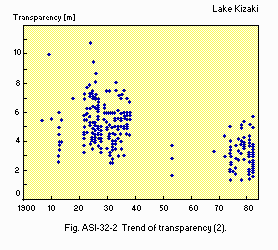
Trend of transparency (2).
F. BIOLOGICAL FEATURES
F1 FLORA (Q)- Emerged macrophytes
Nelumbo nucifera, Zizania latifolia, Eleocharis kurokuwai, Phragmites communis. - Floating macrophytes: Nymphoides peltata, N. tetragona, Trapa japonica.
- Submerged macrophytes
Ceratophyllum demersum, Hydrilla verticillata, Elodea nuttallii. - Phytoplankton: Anabaena sp., Fragilaria crotonensis, Melosira sp.
- Zooplankton
Conochilus sp., Cyclops vicinus, Alona quadrangularis, Colurella sp. - Benthos
Chironomus plumosus, Chaoborus sp., Tubifex sp.,m Tanytarsus sp. - Fish
Leuciscus hakonensis, Zacco platypus, Hypomessua transpacificus, Carassius sp.
- Annual fish catch [metric tons]: ca. 10.
G. SOCIO-ECONOMIC CONDITIONS
G1 LAND USE IN THE CATCHMENT AREA (3)| Area [km2] | [%] | |
|---|---|---|
| Natural landscape | ||
| - Woody vegetation and | 18.61 | 84.4 |
| - Herbaceous vegetation | ||
| Agricultural land | 1.12 | 5.1 |
| Residential area | 0.65 | 2.9 |
| Others | 1.67 | 7.6 |
| Total | 22.05 | 100.0 |
- Main types of woody vegetation (4)
Deciduous broadleaf forest (Fagus crenata, Quercus serrata, Q. mongolica var. grosseserrata, Betula ermanii); evergreen conifer forest (Thuja standishii, Tsuga diversifolia, Abies marieseii); conifer plantation (Larix kaempferi, Cryptomeria japonica). - Main types of herbaceous vegetation: Grassland and alpine plant communities.
| 1980 | ||||
| Population | Population density [km-2] | Major cities (population) | ||
|---|---|---|---|---|
| Total | 1,500 | 63 | None | |
H. LAKE UTILIZATION
H1 LAKE UTILIZATION (Q)-
Fisheries, tourism and recreation (swimming, sport-fishing, yachting).
I. DETERIORATION OF LAKE ENVIRONMENTS AND HAZARDS (Q)
I3 EUTROPHICATION- Nitrogen and phosphorus loadings to the lake [t yr-1](3)
| Sources | Industrial | Domestic | Agricultural | Natural | Others | Total |
|---|---|---|---|---|---|---|
| T-N | 0.66 | 0.96 | 3.42 | 5.87 | 3.23 | 14.14 |
| T-P | 0.05 | 0.16 | 0.16 | 0.23 | 0.19 | 0.79 |
- Extent of damage: None.
J. WASTEWATER TREATMENTS (Q)
J3 SANITARY FACILITIES AND SEWERAGE- Municipal wastewater treatment systems: Not present.
M. LEGISLATIVE AND INSTITUTIONAL MEASURES FOR UPGRADING LAKE ENVIRONMENTS
M1 NATIONAL AND LOCAL LAWS CONCERNED- Names of the laws (the year of legislation)
- For national laws see "Biwa-ko".
- Prefectural Government Code for Prevention of Public Nuisances
- Responsible authorities
- Nagano Prefectural Government
N. SOURCES OF DATA
- Questionnaire filled by Nagano Prefectural Government.
- Horiuchi, S., Anbe, Y. & Obata, H. (1963) Survey of Lake Kizaki basin with an ultrasonic detector (Gyogun-tanchiki ni yoru Kizaki-ko no kobon chosa). J. Geogr. (Chigaku Zasshi), 72: 126-130.*
- Funakoshi, M. (Shinshu University) Personal communication.
- Nagano Prefecture Anti-Public Nuisance Management Association (1985) Study on Nishina-sanko Water Quality Improvement Measures.
- Nagano Prefecture Vegetation Map Study Group (1975) Vegetation Map and Phytosociological Study of Nagano Prefecture, Vol. 2 (Nagano-ken no Shokusei-zu, Shokubutsushakaigakuteki Kenkyu, 2). Nagano Prefectural Government, Nagano.*
- Nagano Prefectural Government (1985) Results of Water Quality Monitoring in Public Water Bodies (Kokyo-suiiki Suishitsu Sokutei Kekka).*
* Printed in Japanese. The titles are tentatively translated into English with original titles in romanized in parentheses.
