OZERO BAYKAL (LAKE BAIKAL)
A coastal view from the cruising vessel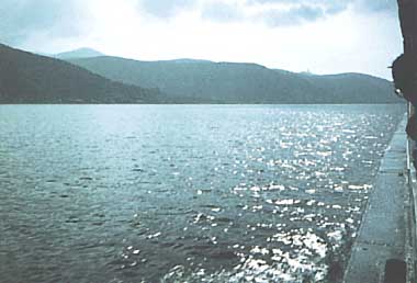
Photo: A. Kurata
A. LOCATION
- Buryat A.S.S.R. and Irkutsk, Russia*
- 51:29-55:46N, 103:40-109:55E; 456 m above sea level.
* Place names are not updated.
B. DESCRIPTION
-
Lake Baikal is the deepest lake in the world. The bottom of the lake lies 1,285 m below sea level, and is the deepest continental rift on the earth. Its water volume is approximately equal to the total volume of the Great Lakes of North America, or to about 20% of the total freshwater on the earth. It is also known as one of the most ancient in geological history, and there are few lakes in the world to compete with this lake in biotic diversity. As many as 852 species and 233 varieties of algae and 1,550 species and varieties of animals have been known to inhabit L. Baikal. The world-famous Baikal seal, the only mammal living on the lake, is found throughout the whole area of the lake to this day.
The lake is completely surrounded by mountains, and there are 22 small islands over the lake. The lake water is fed by some 300 inflowing rivers, and is drained through the single outlet, the Angara River. The climate of the drainage basin is extremely continental with long, very cold and dry winters and short cool summers. The climax vegetation under the climate is the coniferous forest largely dominated by larch. The nutritional level of the lake water is typically oligotrophic as indicated by the highest transparency in the world, though an industrial pulp complex built in the early 1960's near the lake's southern end is said to have caused considerable pollution.
C. PHYSICAL DIMENSIONS (1, 2)
| Surface area [km2] | 31,500 |
| Volume [km3] | 23000 |
| Maximum depth [m] | 1,741 |
| Mean depth [m] | 740 |
| Water level | Unregulated |
| Length of shoreline [km] | 2,000 |
| Catchment area [km2] | 560,000 |
D. PHYSIOGRAPHIC FEATURES
D1 GEOGRAPHICAL- Bathymetric map: Fig. ASI-27-01.
- Names of main islands
Olkhon (ca. 730 km2) and Greater Ushkany (9.4 km2)(2). - Number of outflowing rivers and channels (name): 1 (Angara R.)(1).
- Climatic data at Irkutsk, 1951-1980
| Jan | Feb | Mar | Apr | May | Jun | Jul | Aug | Sep | Oct | Nov | Dec | Ann. | |
|---|---|---|---|---|---|---|---|---|---|---|---|---|---|
| Mean temp. [deg C] | -19.7 | -17.6 | -8.4 | 1.0 | 8.9 | 15.4 | 17.7 | 15.2 | 8.5 | 0.8 | -9.4 | -17.1 | -0.4 |
| Precipitation [mm] | 15 | 8 | 11 | 19 | 27 | 69 | 109 | 86 | 46 | 27 | 17 | 20 | 453 |
- Number of hours of bright sunshine: 2,046 hr yr-1.
- Solar radiation: 11.96 MJ m-2 day-1.
- Snowfall: 0.28 m.
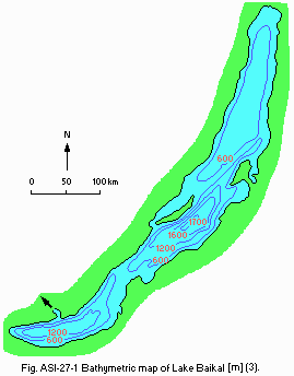
Bathymetric map [m](3).
- Water temperature: Fig. ASI-27-02 and 03.
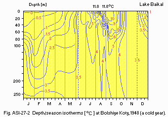
Depth/season isotherms [deg C] at Bolshiye Koty, 1948 (a cold year).
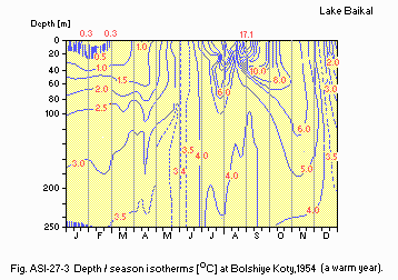
Depth/season isotherms [deg C] at Bolshiye Koty, 1954 (a warm year)(2).
- Freezing period: January-May.
- Mixing type: Dimictic.
- Notes on water mixing and thermocline formation
Usually the thermocline is formed from July to August; the water tends to be homothermy at all depths in June and November.
E. LAKE WATER QUALITY
E1 TRANSPARENCY: Fig. ASI-27-04.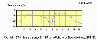
Transparency [m] 1.5 km offshore of Bolshiye Koty, 1956 (2).
E2 pH (1)
-
Surface water
Open area: 7.2-7.8.
Maloye More: 7.3-8.5.
Posolsky Sor: 6.8-8.3.
E4 DO [mg l-1](2)
| Bolshiye Koty, 1952 | ||||
| Depth [m] | Mar | Apr | Aug | Sep |
|---|---|---|---|---|
| 0 | 12.76 | 12.90 | 10.83 | 11.14 |
| 25 | 12.94 | 12.98 | 10.97 | 11.30 |
| 50 | 11.55 | 11.70 | 10.67 | 10.86 |
| 100 | 10.78 | 10.83 | 10.78 | 10.96 |
| 250 | 10.59 | 10.51 | 10.43 | 10.42 |
| 500 | 10.48 | 10.46 | 10.30 | 10.30 |
| 600 | 10.04 | 10.10 | - | - |
| 750 | - | - | 10.20 | 10.17 |
| 800 | 9.92 | 9.87 | - | - |
| 1,000 | 9.74 | 9.77 | 10.14 | 10.08 |
| 1,200 | 9.62 | 9.71 | 10.03 | 10.00 |
| 1,350 | 9.56 | 9.63 | - | - |
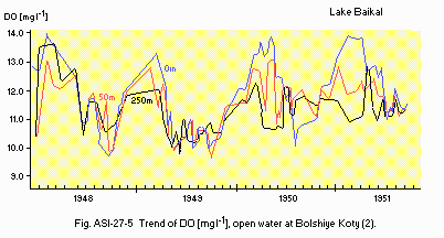
Trend of DO [mg l-1], open water at Bolshiye Koty (2).
F. BIOLOGICAL FEATURES
F1 FLORA (2)- Emerged macrophytes: Phragmites, Scirpus, Sparganium, Sagittaria.
- Floating macrophytes: Lemna, Nuphar, Nymphaea.
- Submerged macrophytes: Potamogeton, Myriophyllum, Ceratophyllum.
- Phytoplankton
Perdinium baicalense, Gymnodinium baicalense, G. coeruleum, Ceratium hirundinella, Glenodinium sp., Mallomonas spp., Uroglena sp., Dinobryon cylindricum, Anabaena flos-aquae, A. limmermannii, Aphanizomenon flos-aquae, Gloeotrichia echnulata, Epichrysis melosirae, Fragillaria crotonensis, Melosira baicalensis, Asterionella formosa, Tabellaria fenestrata, Ceratoneis arcus, Stephanodiscus binderanus, Cyclotella baicalensis, C. minuta, Synedraulna var. danica.
- Zooplankton
Epischura baicalensis, Macrohectopus branickii, Diaptomus graciloides, Heterocope appendiculata, Cyclops kolensis, C. baicalensis, Hislopia placoides, Daphinia longispina, Bosmina longirostris, Keratella quadrate, K. cochlearis, Kellicotia logispina, Filinia terminalis, Collotheca sp., Conochilus sp., Vorticella sp. - Benthos (2)
Spongia (Swartschewskia papyracea, Lumbomirskia baicalensis), Polychaeta (Manayunkia baicalensis), Oligochaeta (Peloscolex inflatus), Mollusca (Benedictia baicalensis, Baicalia angarensis, Pseudancylastrum sibiricum, Valvata baicalensis, Choanomphalus maackii), Turbellaria (Baicalarctia gulo, Sorocelis nigrofasciata, Blellocephala angarensis, Thysanoplana papaillosa), Crustacea (Bathynella baicalensis, B. magna, Asellus anquaticus, Abyssogrammarus sarmatus, Crypturopus pachytus) Insecta (Sergentia l. koschowi, Diamesa baicalensis). - Fish (2)
Comephorus baicalensis, Procottus jettelesi, Cottocomephorus grewingki, Asprocottus kozhowi, Paracottus kneri, P. kessleri, Abysscottus pallidus, Coregonus autumnalis migratorius, C. lavaretus baicalensis, Thymallus arcticus baicalensis, T. arcticus brevipinnis, Hucho taimen, Salvelinus alpinus erithrinus, Brachymystax lenok, Rutilus rutilus lacustris, Leuciscus leuciscus baicalensis, L. idus. - Mammal: Phoca sibirica (2).
- Annual productivity of pelagic organism (1)
| Production rate [mg m-2 yr-1] | Productivity/biomass ratio (P/B) | |
|---|---|---|
| Phytoplankton | 2,100 | 304 |
| Bacteria | 748 | 32 |
| Zooplankton, phytophagous | 178 | 13.5 |
| Zooplankton, carnivorous | 10 | 11 |
| Fish, non-commercial | 4.1 | 0.8-1 |
| Fish, commercial | 0.15 | 0.2 |
| Seal | 0.01 | 0.12 |
- Primary production rate: Fig. ASI-27-06.
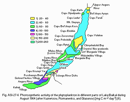
Photosynthetic activity of the phytoplankton in different parts of Lake Baikal during August 1964 (after Kuznetsov, Romanenko, and Glazunov)[mg C m-2 day- 1](6).
F4 BIOMASS
- Benthic animals [g (fresh wt.) m-2](2)
| Littoral | Sublittoral and supra-abyssal | |||||||
|---|---|---|---|---|---|---|---|---|
| Substratum | Sand | Sand | Sand black | with silt | Black silt | Brown silt | Sand | Silt |
| Depth [m] | 1-10 | 10-20 | 6-17 | 2-10 | 1.5-4 | 20-30 | 40-50 | 20-250 |
| Gammaridae | 4.24 | 3.78 | 15.60 | 12.20 | 5.80 | 0.85 | 5.65 | 2.01 |
| Oligochaeta & | 5.89 | 4.26 | 22.40 | 7.90 | 0.60 | 0.86 | 20.13 | 3.24 |
| Polychaeta | ||||||||
| Mollusca | 16.81 | 21.15 | 10.40 | 9.30 | 2.50 | 10.50 | 0.10 | 0.03 |
| Turbellaria | 2.13 | 0.09 | 0.20 | 0.30 | 0.40 | - | 0.88 | - |
| Hirudinea | 0.04 | - | 1.50 | 3.20 | 2.20 | 0.08 | 0.04 | - |
| Insecta | 0.16 | 0.38 | - | 0.80 | 0.50 | - | - | - |
| Total | 29.27 | 29.96 | 50.10 | 33.70 | 12.00 | 12.29 | 26.79 | 5.28 |
- Faunal [metric tons per lake](7)
Zooplankton: 462,000. Zoobenthos: ca. 700,000. Fish: ca. 230,000.
- Mean perennial indices of biomass, production and fish catch (B. K.
| Biomass | Production | Catch | |||||||
|---|---|---|---|---|---|---|---|---|---|
| kt. | % | kg/ha | kt. | % | kg/ha | kt. | % | kg/ha | |
| Omul | 30.0 | 13.4 | 9.7 | 10.0 | 5.1 | 3.2 | 7.3 | 55.7 | 2.3 |
| Sor fish | 20.0 | 8.9 | 6.5 | 8.0 | 4.1 | 2.6 | 4.0 | 30.5 | 1.3 |
| Other food-fish | 4.0 | 1.8 | 1.3 | 1.2 | 0.6 | 0.4 | 1.0 | 7.6 | 0.3 |
| Bottom bullheads | 10.0 | 4.5 | 3.2 | 10.0 | 5.1 | 3.2 | - | - | - |
| Pelagic bullheads | 10.0 | 4.5 | 3.2 | 15.0 | 7.7 | 4.8 | 0.8 | 6.1 | 0.3 |
| Golomyanka | 150.0 | 67.0 | 48.4 | 150.0 | 77.3 | 48.0 | - | - | - |
| Total | 224.0 | 100 | 72.4 | 194.2 | 100 | 62.4 | 13.1 | 100 | 4.2 |
- Annual fish catch [metric tons]
1946-1955: 12,000-13,000.
- Perennial dynamics of phytoplankton (spring survey, maximum, 25 m layer)(8)
| Southern Baikal | Central Baikal | Northern Baikal | ||||
|---|---|---|---|---|---|---|
| Year | mg m-3 | mg m-2 | mg m-3 | mg m-2 | mg m-3 | mg m-2 |
| 1964 | 2,830.5 | 70,762.5 | 1,972.3 | 49,307.5 | 250.8 | 6,270.0 |
| 1965 | 1,277.7 | 31,942.5 | 236.0 | 5,900.0 | 467.8 | 11,690.0 |
| 1966 | 84.0 | 2,100.0 | 2,425.0 | 6,062.5 | 29.2 | 730.0 |
| 1967 | 31.3 | 782.5 | 846.1 | 22,152.5 | 1,561.9 | 39,047.5 |
| 1968 | 4,163.4 | 104,085.0 | 1,859.1 | 46,477.5 | 894.6 | 22,365.0 |
| 1969 | 828.1 | 20,702.5 | 109.8 | 2,745.3 | 22.3 | 556.3 |
| 1970 | 46.0 | 1,150.5 | 70.8 | 1,770.5 | 13.7 | 341.3 |
| 1971 | 204.0 | 5,100.0 | 574.4 | 14,360.0 | 245.0 | 6,125.5 |
| 1972 | 426.0 | 10,650.3 | 148.8 | 3,720.8 | 338.1 | 8,453.5 |
| 1973 | 67.7 | 1,691.5 | 491.8 | 12,294.8 | 3,075.0 | 768.8 |
| 1974 | 2,379.5 | 59,487.5 | 311.4 | 7,785.0 | 97.4 | 2,435.8 |
| 1975 | 370.6 | 9,263.8 | 717.0 | 17,923.8 | 127.8 | 3,194.3 |
| 1976 | 1,575.3 | 39,381.8 | 687.7 | 17,193.8 | 778.2 | 19,456.0 |
| 1977 | 512.6 | 12,812.8 | 486.5 | 12,162.0 | 106.6 | 2,666.0 |
| 1978 | 226.3 | 5,657.5 | 551.5 | 13,788.0 | 103.3 | 2,581.3 |
| 1979 | 2,365.8 | 59,146.0 | 11,809.0 | 29,523.5 | 1,222.1 | 30,552.5 |
| 1980 | 628.8 | 15,720.5 | 602.0 | 15,048.8 | 52.8 | 131.9 |
| 1981 | 58.2 | 1,454.0 | 434.5 | 10,863.3 | 23.0 | 396.5 |
| 1982 | 1,394.3 | 34,857.5 | 2.341.8 | 58,543.8 | 176.4 | 4,409.5 | Mean perennial |
| 1,024.7 | 25,618.3 | 729.7 | 18,243.3 | 344.3 | 8,608.3 |
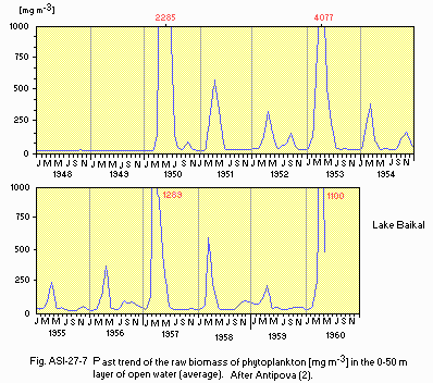
Past trend of the raw biomass of phytoplankton [mg m-3] in the 0-50 m layer of open water (average). After Antipova (2).
G. SOCIO-ECONOMIC CONDITIONS
G1 LAND USE IN THE SURROUNDING TERRITORIES (9)| Area [km2] | |
|---|---|
| Agricultural land | 5,442.48*1 |
| - Crop field | 145.04*2 |
| - Hay land and Pasture land | 4,140.44*2 |
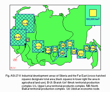
Industrial development areas of Siberia and the Far East (cross-hatched squares designate total area; black squares in lower right the area in agricultural land use). B-UI: Bratsk-Ust'-Ilimsk territorial-production complex. U-L: Upper Lena territorial-production complex. NB: North Baikal territorial.production complex. Ud: Udokan economic node.
- Numbers of domestic animals in B-Ul, U-L, NB and Ud areas: Cattle 41,600,
poultry 450,000. - Trends of change in land use
Siberia and the Soviet Far East are currently the scene of ambitious resource development programs: territorial-production complexes are being built up as the nuclei for the intensive industrial development of what were until recently virtually uninhabited areas, and a region rich in raw materials is to be opened up in the east by the construction of the Baikal-Amur Mainline. Manpower is being shifted to these pioneering areas, and new towns are rising in the taiga and in the wooded steppe. An increasingly urgent issue that arises in connection with the growth of population in the eastern regions is the provision of food, especially perishables such as potatoes, vegetables, milk and meat. The situation is to be remedied, especially with regard to the continuing growth of population, through implementation of the Soviet Union's Food Program, whose objectives have been outlined through the year 1990.
| 1985 | ||||||
| Population | Population density [km-2] | Major cities (population) | ||||
|---|---|---|---|---|---|---|
| Urban | 3,655,000 | - | Irkutsk (597,000), | |||
| Rural | 1,395,000 | 9.0 | Ulan-Ude (335,000), | |||
| Total | 5,060,000 | 9.0 | Ulan-Bator | |||
I. DETERIORATION OF LAKE ENVIRONMENTS AND HAZARDS
I3 EUTROPHICATION- Nuisance caused by eutrophication (11): None.
- Nitrogen and phosphorus loadings to the lake [t yr-1](12)
T-N: 286,000, T-P: 62,000.
J. WASTEWATER TREATMENTS (12)
J3 SANITARY FACILITIES AND SEWERAGE- Number of Industrial wastewater treatment systems: 1.
N. SOURCES OF DATA
- Limnological Institute of the Siberian Branch, Academy of Sciences of the USSR (1979) Lake Baikal-Guidebook. 76 pp. Publishing Office "Nauka", Moscow.
- Kozhov, M. (1963) Lake Baikal and Its Life. 344 pp. Dr. W. Junk Publishers, The Hague.
- Hutchinson, G. E. (1975) A Treatise on Limnology, Vol.1. Part 1, Geography and Physics of Lakes. 540 pp. Wiley-Interscience, New York.
- Tokyo Astronomical Observatory (1986) Chronological scientific Tables (Rika Nenpyo). 1007 pp. Maruzen Co., Tokyo.*
- Okamoto, K. & Horie, S. (1983) On the Zooplankton of Lake Baikal: A Preliminary Report. Jap. J. Limnol., 44(1): 59-64.
- Kuznetsov, S. I. (1970) The Microflora of Lakes and Its Geochemical Activity (ed. Oppenheimer, C. H.), pp. 503. University of Taxas press, Austin and London.
- Galazy, G. I. (1980) Lake Baikal and Its Protection. Abstracts of the 21st Congress of International Association of Theoretical and Applied Limnology: 104.
- Galazy, G. I. & Linevich, A. A. (1988) Ecosystem of Lake Baikal. Report to the UNCRD/ILEC/UNEP Expert Group Workshop on River/Lake Basin Approach to Environmentally Sound Management of Water Resources, Otsu and Nagoya, February 1988, 18 pp.
- Wein, N. (1984) Agriculture in the Pioneering Regions of Siberia and the Far East: Present Status, Problems and Prospects. Soviet Geography, 25 (8): 592-620.
- Hausladen, G. (1987) Recent Trends in Siberian Urban Growth. Ibid, 28 (2): 71-89.
- Ghilarov, A. M. (1983) Report on Eutrophication Studies in the U.S.S.R. Water Res., 17 (6): 607-611.
- Olga Kojeva (1983) Present condition of environmental protection of Lake Baikal and other Siberian lakes (include reservoirs)(Baikaru-ko o hajimeto suru shiberia no kosho (chosuichi o fukumu) no kankyo hogo no genjo). Water Purification and Liquid Wastes Treatment. 24 (11): 889 893.*
* Printed in Japanese with the original titles in romanized Japanese in parentheses.


