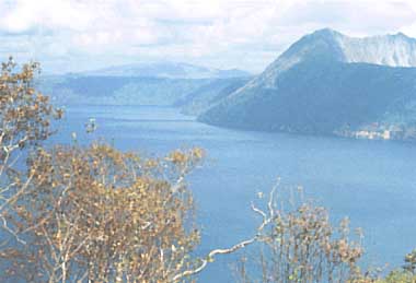
Lake Mashu is located in the eastern part of Akan National Park and is known as a mysterious scenic spot. The "mystery" is attributed to the fact that the lake can be rarely seen in the summer tourist season due to frequent heavy fog. The Environment Agency prohibits entry to the lakeshore area and allows only viewing from observation towers.
It is a beautiful crater lake with its steep encircling wall in complete shape. There is a 300 meter high overhanging cliff in the western part of the crater wall. In the center of the lake there is an oval-shaped small island, Bentenjima (Kamuisshu in Ainu language), 70 m x 50 m in size. The central portion of the island stands 25 m above the water surface. The maximum depth of the lake is 211.5 m and the lake bottom is almost flat and covered by pumice deposits.
There are two inflowing streams, but no observable outlet from the lake exists. It is believed that the lake water seeps out through porous bottom sediments, since the water level remains fairly constant. The lake is oligotrophic and the lake water appears indigo-blue. The transparency of 41.6 m measured in August 31,1931 was said to be the highest in the world, surpassing that of Lake Baikal at that time (40.5 m). The transparency has, however, decreased substantially in recent years (Q).
C. PHYSICAL DIMENSIONS (Q)
Surface area [km2]
19
Volume [km3]
2.7
Maximum depth [m]
211.5
Mean depth [m]
141.3
Length of shoreline [km]
19.8
Catchment area [km2]
33
D. PHYSIOGRAPHIC FEATURES (Q)
D1 GEOGRAPHICAL
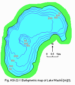
Bathymetric map: Fig. ASI-22-01.
Names of main islands: Bentenjima (70 m x 50 m).
Number of outflowing rivers and channels (name): None.
G1 LAND USE IN THE CATCHMENT AREA
Natural landscape 100%.
Main types of woody vegetation
Evergreen conifer forest (Picea jezoensis, Abies sachalinensis); birch forest (Betula ermanii).
G3 POPULATION IN THE CATCHMENT AREA
None.
H. LAKE UTILIZATION
H1 LAKE UTILIZATION
No direct uses; sightseeing.
J. WASTEWATER TREATMENTS
J1 GENERATION OF POLLUTANTS IN THE CATCHMENT AREA
a) Pristine lake environments.
M. INSTITUTIONAL MEASURES
M3 RESEARCH INSTITUTES ENGAGED IN THE LAKE ENVIRONMENT STUDIES
Hokkaido Research Institute for Environmental Pollution, Sapporo
National Institute for Environmental Studies, Tsukuba
N. SOURCES OF DATA
Questionnaire filled by Hokkaido Research Institute for Environmental Pollution.
Geogr. Survey. Inst., Ministry of Construction (1986) 1:10,000 Map of Lake Mashu (1:10,000 Kosho zu, Mashu-ko).* * Printed in Japanese. The title is tentatively translated into English with the original title in romanized Japanese in parentheses.