
AKAN-KO (LAKE AKAN)
Near the southeastern end of the lake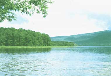
Photo: T. Kira
A. LOCATION
- Hokkaido, Japan.
- 43:27N, 144:06E; 420 m above sea level.
B. DESCRIPTION
-
Lake Akan in eastern Hokkaido is a dammed lake formed approximately 6,000 years ago by volcanic activity in a caldera depression that dates back to the middle Pleistocene. Its complicated shoreline is characteristic of dammed lakes. The lake is famous as the only native habitat of "Marimo" or fine ball-like masses of the alga, Aegagropila sauteri, 2-15 cm in diameter. It is believed that the globular shape is formed by the aggregation of filamentous alga and the rotary motion due to water turbulence. Similar kinds of spherical algal mass are observed in a few other lakes of Japan, but they are more irregular in shape. L. Akan is also known as the original home of kokanee salmon (Oncorhynchus nerka).
Transparency in the early 1930's was 8-9 m throughout the year, but the lake has recently been eutrophicated to a considerable extent owing to the inflowing waste water from the hot-spring town on the coast in spite of its cool and deep water. The eutrophication exerted a profound influence on the benthic fauna, which had once consisted of Chironomidae, Tubificidae, Chaoborus and Pisidium in its deepest bottom. According to the result of a general limnological survey made in 1973, however, the dissolved oxygen concentration in bottom water was only around 5% of saturation and no organisms were observed beyond a depth of 30 m (1, 2, 3).
C. PHYSICAL DIMENSIONS (Q, 4, 5)
| Surface area [km2] | 13 |
| Volume [km3] | ca. 0.23 |
| Maximum depth [m] | 44.8 |
| Mean depth [m] | 17.8 |
| Length of shoreline [km] | 25.9 |
| Catchment area [km2] | 148 |
D. PHYSIOGRAPHIC FEATURES
D1 GEOGRAPHICAL- Bathymetric map: ASI-21-01.
- Number of outflowing rivers and channels (name): 1 (Akan R.).
- Climatic data on the shore, 1982-1983
| Jan | Feb | Mar | Apr | May | Jun | Jul | Aug | Sep | Oct | Nov | Dec | Ann. | |
|---|---|---|---|---|---|---|---|---|---|---|---|---|---|
| Mean temp. [deg C] | -10.4 | -12.2 | -5.4 | 3.2 | 8.9 | 9.7 | 14.8 | 18.0 | 12.7 | 6.5 | 0.6 | -6.1 | 3.4 |
| Precipitation [mm] | 57 | 11 | 73 | 82 | 70 | 100 | 69 | 166 | 106 | 138 | 95 | 47 | 1,014 |
- Number of hours of bright sunshine (L. Akan): 2,218 hr yr-1.
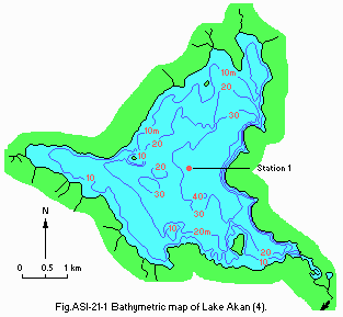
Bathymetric map (4).
- Water temperature [deg C](Q)
| Station 1, 1981-1983 | ||||||||||||
| Depth [m] | Jan | Feb | Mar | Apr | May | Jun | Jul | Aug | Sep | Oct | Nov | Dec |
|---|---|---|---|---|---|---|---|---|---|---|---|---|
| 0 | - | - | - | - | 8.4 | 12.6 | 18.5 | 19.3 | 18.1 | 12.9 | - | - |
| 5 | - | - | - | - | 8.8 | 12.5 | 17.3 | 18.7 | 17.9 | 12.7 | - | - |
- Freezing period: December-April.
- Mixing type: Dimictic.
E. LAKE WATER QUALITY (Q)
E1 TRANSPARENCY [m]| Station 1, 1981-1983 | ||||||||||||
| Depth [m] | Jan | Feb | Mar | Apr | May | Jun | Jul | Aug | Sep | Oct | Nov | Dec |
|---|---|---|---|---|---|---|---|---|---|---|---|---|
| - | - | - | - | 3.4 | 4.4 | 3.5 | 3.8 | 3.1 | 2.4 | - | - | |
| Station 1, 1981-1983 | ||||||||||||
| Depth [m] | Jan | Feb | Mar | Apr | May | Jun | Jul | Aug | Sep | Oct | Nov | Dec |
|---|---|---|---|---|---|---|---|---|---|---|---|---|
| 0 | - | - | - | - | 7.7 | 7.9 | 8.3 | 8.2 | 8.0 | 7.7 | - | - |
| 5 | - | - | - | - | 7.8 | 7.9 | 8.2 | 8.2 | 8.1 | 7.7 | - | - |
| Station 1, 1981-1983 | ||||||||||||
| Depth [m] | Jan | Feb | Mar | Apr | May | Jun | Jul | Aug | Sep | Oct | Nov | Dec |
|---|---|---|---|---|---|---|---|---|---|---|---|---|
| 0 | - | - | - | - | 1 | 1 | 2 | 1 | 1 | 3 | - | - |
| 5 | - | - | - | - | 2 | 1 | 2 | 1 | 1 | 3 | - | - |
| Station 1, 1981-1983 | ||||||||||||
| Depth [m] | Jan | Feb | Mar | Apr | May | Jun | Jul | Aug | Sep | Oct | Nov | Dec |
|---|---|---|---|---|---|---|---|---|---|---|---|---|
| 0 | - | - | - | - | 9.9 | 8.8 | 9.3 | 8.1 | 9.1 | 8.2 | - | - |
| 5 | - | - | - | - | 9.4 | 8.7 | 9.0 | 7.9 | 8.3 | 8.1 | - | - |
| Station 1, 1981-1983 | ||||||||||||
| Depth [m] | Jan | Feb | Mar | Apr | May | Jun | Jul | Aug | Sep | Oct | Nov | Dec |
|---|---|---|---|---|---|---|---|---|---|---|---|---|
| 0 | - | - | - | - | 2.1 | 2.3 | 3.0 | 2.8 | 2.9 | 3.0 | - | - |
| 5 | - | - | - | - | 2.4 | 2.3 | 3.0 | 2.7 | 3.4 | 3.1 | - | - |
- Total-N [mg l-1]
| Station 1 1981-1983 | ||||||||||||
| Depth [m] | Jan | Feb | Mar | Apr | May | Jun | Jul | Aug | Sep | Oct | Nov | Dec |
|---|---|---|---|---|---|---|---|---|---|---|---|---|
| 0 | - | - | - | - | 0.14 | 0.13 | 0.14 | 0.17 | 0.15 | 0.38 | - | - |
| 5 | - | - | - | - | 0.12 | 0.18 | 0.15 | 0.31 | 0.15 | 0.44 | - | - |
- Total-P [mg l-1]
| Station 1, 1981-1983 | ||||||||||||
| Depth [m] | Jan | Feb | Mar | Apr | May | Jun | Jul | Aug | Sep | Oct | Nov | Dec |
|---|---|---|---|---|---|---|---|---|---|---|---|---|
| 0 | - | - | - | - | 0.036 | 0.024 | 0.025 | 0.035 | 0.054 | 0.049 | - | - |
| 5 | - | - | - | - | 0.041 | 0.029 | 0.015 | 0.032 | 0.035 | 0.052 | - | - |
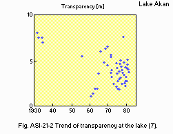
Trend of transparency at the lake centre (7).
F. BIOLOGICAL FEATURES (Q)
F1 FLORA- Emerged macrophytes: Phragmiltes communis.
- Floating macrophytes: Nuphar sp.
- Submerged macrophytes
Potamogeton crispus, Hydrilla verticillata, Myriophyllum verticillatum, Vallisneria gigantea. - Phytoplankton: Melosira italica, Asterionella formosa, Synedra sp.
- Zooplankton: Daphnia longiremis, Bosmina coregoni, Eurytemora affinis.
- Benthos: Chironomus plumosus, Tubificidae.
- Fish
Oncorhynchus nerka, Cyprinus carpio, Carassius sp., Hypomesus olidus, Leuciscus hakonensis.
- Annual fish catch [metric tons]
1979: 139.
G. SOCIO-ECONOMIC CONDITIONS (Q)
G1 LAND USE IN THE CATCHMENT AREA| Area [km2] | [%] | |
|---|---|---|
| Natural landscape | ||
| - Woody vegetation | 147 | 99.3 |
| Residential area | 1 | 0.7 |
| Total | 148 | 100.0 |
- Main types of woody vegetation (8)
Deciduous broadleaf forest (Betula ermanii, Quercus mongolica var. grosseserrata, Acer mono, Cercidiphyllum japonicum); evergreen conifer forest (Picea jezoensis, Abies sachalinensis).
| No.of establishments | Main products or major industries | |
|---|---|---|
| Primary industry | ||
| Fisheries | - | Kokanee salmon, smelt and carp |
| Tertiary industry | Several facilities for tourists | |
| 1982 | |||
| Population | Population density [km-2] | Major cities (population) | |
|---|---|---|---|
| Rural | 2,100 | - | |
| Total | 2,100 | 14.4 | |
H. LAKE UTILIZATION
H1 LAKE UTILIZATION-
Tourism, recreation (sport-fishing, yachting) and fisheries.
M. LEGISLATIVE AND INSTITUTIONAL MEASURES FOR UPGRADING LAKE ENVIRONMENTS
M1 NATIONAL AND LOCAL LAWS CONCERNED-
For national laws see "Biwa-ko".
N. SOURCES OF DATA
- Questionnaire filled by the Prefectural Government of Hokkaido.
- Imada, K., Ito, T., Yoshizumi, Y. & amp;Yonekawa, T. (1981) Fluctuations of transparency, COD and several dissolved ions in Lake Akan (1973-1980). Sci. Rep. Hokkaido Fish Hatchery, 36: 33-50.*
- Miyadi, D. (1932) Studies on the bottom fauna of Japanese Lakes VII. Lakes of Hokkaido. Jap. J. Zool., 4: 223-252.
- Kitagawa, N. (1976) Studies on the benthos fauna of four lakes (Kussharo, Akan, Toro, Shikaribetsu) in the eastern part of Hokkaido. Jap. J. Limnol., 37: 37-41.*
- Japan Map Centre, (ed.)(1982) Collection of Maps on Japanese Lakes (Technical Data of National Geographical Institute, D 1-No.221). National Geographical Institute, Tsukuba.*
- Horie, M. (1956) Morphometry of Japanese lakes. Jap. J. Limnol., 18: 1 28.
- Uchida, E., Asakura, T. & Kawamura, T., (ed.)(1983) Meteorological Data of Japan. 1060 pp. Toyo-keizaishinpo-sha, Tokyo.*
- Yoshizumi, Y., Ito, T., Imada, K., Awakura, T. & Okamoto, M. (1976) Water quality of Lake Akan and inflowing rivers (1972-1976). Sci. Rep. Hokkaido Fish Hatchery, 31: 113-154.*
* Printed in Japanese. The titles are tentatively translated into English.
