
BUNG BORAPHET (BORAPED RESERVOIR)
Fishing boats on the lake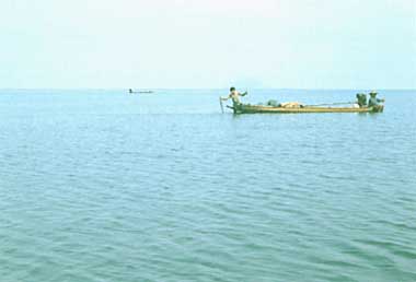
Photo: T. Kira
A. LOCATION
- Nakhon Sawan Province, Thailand.
- 15:50N, 100:10E; 23.8 m above sea level.
B. DESCRIPTION
-
Bung (= big pond) Boraped is a half man.made reservoir originating from a natural retarding basin situated close to the city of Nakhon Sawan, where the two rivers, Mae Nam Nan and Mae Nam Ping. unite into Mae Nam Chao Phraya (sometimes erroneously called the Menam River). The lake area had been a vast retarding basin known as the Boraped Swamp, which formed a big lake of 600 km2 in seasons of high water level while turning into a grass-covered plain with scattered ponds and swampy depressions during the dry season. A dam was built at the head of the main outflowing channel (Klong Boraped) by the Fishery Department of Thailand in 1926-30 mainly for increasing fish production. Part of the swamp thus turned into a lake which has since been known as Bung Boraped. The present lake area is about 106 km2 at the spill level, but it varies extensively owing to the water level fluctuation, amounting to as much as 300 km2 in time of floods.
The majority of some 30,000 people living around the lake gain their livelihood from both farming and fishing. Since the lake is the largest source of fishery products for central Thailand, the Nakhon Sawan Fishery Station was established at Klong Boraped for the study of fish biology and for stocking the lake with artificially grown fry. Bung Boraped and surrounding swampy areas form one of the non-hunting nature reserves established by the Royal Thai Forest Department. Two development projects have been drafted for tourism development, upgrading aquaculture and utilizing the lake as sources of irrigation and domestic water supply (Q, 1, 2, 3).
C. PHYSICAL DIMENSIONS
| Surface area [km2] | 106 |
| Volume [km3] | 0.2764 |
| Maximum depth [m] | 5.8 |
| Mean depth [m] | 2 |
| Water level | Regulated |
| Normal range of annual water | |
| - level fluctuation [m] | 1-1.2 |
| Length of shoreline [km] | 53-62.5* |
| Catchment area [km2] | 4,200 |
D. PHYSIOGRAPHIC FEATURES
D1 GEOGRAPHICAL- Sketch map: Fig. ASI-19-01.
- Number of outflowing rivers and channels (name): 1 (Klong Boraped).
- Climatic data at Nakhon Sawan, 1951-1970
| Jan | Feb | Mar | Apr | May | Jun | Jul | Aug | Sep | Oct | Nov | Dec | Ann. | |
|---|---|---|---|---|---|---|---|---|---|---|---|---|---|
| Mean temp. [deg C] | 24.9 | 27.7 | 30.2 | 31.4 | 30.5 | 29.4 | 28.9 | 28.5 | 28.0 | 27.6 | 26.3 | 24.4 | 28.2 |
| Precipitation [mm] | 12 | 25 | 43 | 72 | 141 | 134 | 144 | 167 | 264 | 152 | 30 | 6 | 1,187 |
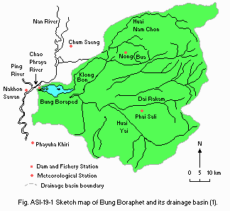
Sketch map of Bung Boraped and its drainage basin (1).
- Water temperature [deg C](2)
| Open water area, 1975 | ||||||||||||
| Depth [m] | Jan | Feb | Mar | Apr | May | Jun | Jul | Aug | Sep | Oct | Nov | Dec |
|---|---|---|---|---|---|---|---|---|---|---|---|---|
| S* | 29.0 | 28.0 | 28.0 | 33.5 | 34.0 | 31.0 | 29.0 | 28.0 | 30.0 | 31.0 | 29.0 | 29.0 |
- Freezing period: None.
- Mixing type: Polymictic.
- Notes on water mixing and thermocline formation
The thermocline is not formed.
E. LAKE WATER QUALITY
E1 TRANSPARENCY [m](2)| Open water area, 1975 | |||||||||||||
| Depth [m] | Jan | Feb | Mar | Apr | May | Jun | Jul | Aug | Sep | Oct | Nov | Dec | |
|---|---|---|---|---|---|---|---|---|---|---|---|---|---|
| 1.4 | 1.7 | 1.2 | 1.8 | 1.5 | 1.3 | 1.3 | 1.1 | 1.1 | 1.3 | 1.2 | 1.2 | ||
| 1975 | ||||||||||||
| Depth [m] | Jan | Feb | Mar | Apr | May | Jun | Jul | Aug | Sep | Oct | Nov | Dec |
|---|---|---|---|---|---|---|---|---|---|---|---|---|
| S* | 7.6 | 7.4 | 7.4 | 7.0 | 7.4 | 7.0 | 7.2 | 7.3 | 6.7 | 6.6 | 7.0 | 6.9 |
-
Surface water*, 1981: 14.8 (July), 2.0 (August).
* Mean of five sampling points.
| 1975 | ||||||||||||
| Depth [m] | Jan | Feb | Mar | Apr | May | Jun | Jul | Aug | Sep | Oct | Nov | Dec |
|---|---|---|---|---|---|---|---|---|---|---|---|---|
| S*1 | 8.0 | 8.0 | 8.0 | 6.0 | 8.0 | 7.0 | 9.0 | 8.0 | 3.0 | 8.0 | 8.0 | 7.0 |
| B*2 | 7.0 | 5.0 | 7.0 | 6.0 | 6.0 | 6.0 | 9.0 | 7.0 | 3.0 | 8.0 | 7.0 | 7.0 |
-
Determined by KMnO4 method.
Surface water*, 1981: 40.5 (July), 22.4 (August).
* Mean of five sampling points.
E6 CHLOROPHYLL CONCENTRATION
-
No information.
E7 NITROGEN CONCENTRATION [mg l-1](1)
-
Mean of five sampling points, 1981
Surface water
- NH4-N: 0.50 (July), 0.01 (August).
- Org-N: 1.5 (July), 1.0 (August).
- PO4-P [mg l-1]
| 1975*1 | ||||||||||||
| Depth [m] | Jan | Feb | Mar | Apr | May | Jun | Jul | Aug | Sep | Oct | Nov | Dec |
|---|---|---|---|---|---|---|---|---|---|---|---|---|
| S*2 | 0.07 | 0.10 | 0.13 | 0.13 | 0.07 | 0.07 | 0.07 | 0.07 | 0.10 | 0.13 | 0.07 | 0.10 |
*2 Surface.
F. BIOLOGICAL FEATURES (Q, 2, 4, 5)
F1 FLORA- Emerged macrophytes
Phragmites karka, Colocasia esculenta, Nelumbo nucifera, Coix aquatica, Isachne globosa, Leesia hexandra. - Floating macrophytes
Salvinia cucullata, Eichhornia crassipes, Pistia stratiotes, Nymphaea stellata. - Submerged macrophytes
Utricularia flexuosa, Potamogeton sp., Hydrila verticillata, Najas graminea, Ceratophyllum demersum. - Phytoplankton
Sphaerozosma vertebratum, Oedogonium sp., Micrasterias foliacea, Synedra ulina, Volvox aureus.
- Zooplankton
Bosmina excisum, Bosminopsis deitersi, Heliodiaptomus kikuchii, Keratella valga. - Benthos
Chironomids, Oligochaeta, Mollusca (Ensidens ingallsianus, Unio thaiensis, Corbicula larnaudieri, C. petiti, Mekongia hainesiana), Crustacea (including a big prawn, Macrobrachium rosenbergii). - Fish
Pristolepsis fasciatus, Notopterus notopterus, Osteochei hasselti, Hampala microlepidota, Ambasis siamensis, Cyclochcilichthys armatus, Mystus vittatus, Ophiocephalus striatus, Clupeoides hypselosoma, Labiobarbus liniatus.
-
No information.
| Wet weight | Dry weight | |
|---|---|---|
| Phytoplankton | 146,000 | 0.143 |
| Zooplankton | 245,300 | 0.104 |
| Total Biomass | 0.247 |
- Population density (open water area, Sep.-Nov., 1981)(1).
Phytoplankton 4.847.5 [l-1]; zooplankton 76.5 [l-1]; benthos 248 [m-2].
- Annual fish catch [metric tons]
1975: 723,048.
G. SOCIO-ECONOMIC CONDITIONS
G1 LAND USE IN THE CATCHMENT AREA* (1)| 1980 | ||||
| Area [km2] | [%] | |||
|---|---|---|---|---|
| Natural landscape | ||||
| - Woody vegetation | 1,734 | 16.3 | ||
| - Swamp | 104 | 1.0 | ||
| - Others (open water) | 213 | 2.0 | ||
| Agricultural land | 7.258 | 68.3 | ||
| Residential area | 1.314 | 12.4 | ||
| Total | 10,622 | 100.0 | ||
- Main types of woody vegetation (4)
Secondary forests derived from the original semi-deciduous seasonal forest. - Main kinds of crops
Rice, sugarcane, sorghum, maize, cassava, soybean, tobacco, sesame and lotus. - Levels of fertilizer application on crop fields: Light.
- Trends of change in land use in recent years (Q)
Increasing number of acreage is now being allocated to fish ponds and livestock raising. Area used as fish ponds amounts to 2.78% of the catchment area.
| No. of persons engaged | No. of establishments | Main products or major industries | ||
|---|---|---|---|---|
| Primary industry | ||||
| - Agriculture | 521,800 | N.A. | ||
| Secondary industry | ||||
| - Manufacturing | 114,900 | 831*2 | Sugar, cement. matches Marble, gypsum,iron, lime | |
| - Mining | 6,437*3 | N.A. | ||
| Tertiary industry | 22,700 | N.A. | ||
*2 Besides there are 401 rice mills.
*3 Including the number of persons engaged in commerce.
| 1980 | |||
| Population | Population density [km-2] | Major cities (population) | |
|---|---|---|---|
| 979,200 | 92.19?*2 | Nakhon Sawan (86,000) | |
*2 Population density for the subdistricts around Bung Boraped: 153.8 km-2.
H. LAKE UTILIZATION
H1 LAKE UTILIZATION (Q)-
Sources of water, fisheries, navigation and tourism.
H2 THE LAKE AS WATER RESOURCE (Q)
-
1980
Domestic: 300 [m3 day-1].
I. DETERIORATION OF LAKE ENVIRONMENTS AND HAZARDS
I1 ENHANCED SILTATION (Q)- Extent of damage: Not serious.
- Supplementary notes
Heavy rainfall in the later part of the year and resultant soil erosion cause high turbidity of water and reduction of plankton, benthos and fish populations.
I3 EUTROPHICATION (Q)
- Nuisance caused by eutrophication: Foul smell of tap water.
J. WASTEWATER TREATMENTS (Q)
J1 GENERATION OF POLLUTANTS IN THE CATCHMENT AREA-
f) Limited pollution without wastewater treatment.
-
No information.
J3 SANITARY FACILITIES AND SEWERAGE
- Public sewerage system: Not present.
L. DEVELOPMENT PLANS (Q)
-
The policy of Department of Fisheries (DOF) in the rehabilitation and
development of these swamps is directed toward optimizing fish production by
controlling floods, ensuring domestic water supply and sanitary facilities,
and allowing limited water use for agricultural purposes.
M. LEGISLATIVE AND INSTITUTIONAL MEASURES FOR UPGRADING LAKE ENVIRONMENTS
M1 NATIONAL AND LOCAL LAWS CONCERNED (Q)- Names of the laws (the year of legislation)
- Fisheries Act BE 2490
- Land Law
- Forestry Law
- Environmental Act
- Responsible authorities
- Department of Fisheries
- Land Department
- The Royal Forestry Department
- National Environment Board
- Main items of control
- Conservation of fishery resources and control of fishing gears
- Control of land use development
- Conservation of forestry and wildlife
- Control of environmental quality
- Department of Fisheries
- Nakhon Sawan Fishery Station, Department of Fisheries, Klong Boraped
N. SOURCES OF DATA
- Questionnaire filled by the Office of the National Environment Board of Thailand, Bangkok.
- Asian Institute of Technology (1982) Rehabilitation and Development of Bung Boraped and Mong Han. Vol. 1. Bung Boraped. 196pp. Office of the National Economic and Social Development Board, Bangkok.
- Suraswadi, Plodprasop (1976) Newly covered grass as a habitat for fish in Bung Boraped, Thailand. Ph. D. Thesis, Department of Zoology, University of Manitoba, Canada.
- Dobias, R. J. (1982) The Shell Guide to the National Parks of Thailand. 137pp. The Shell Company of Thailand, Ltd., Bangkok.
- The editors' observation.
- Mizuno, T. & Mori, S. (1970) Preliminary hydrobiological survey of Southeast Asian inland waters. Biol. J. Limnol., Soc., 22: 11-117.
- Department of Fisheries (1985) Large Swamps Inland Fisheries Project (LSIFP). Bangkok.
