TOYA-KO (LAKE TOYA)

Western part of the lake with Usu volcanos

Photo.
Photo: A. Kurata


A. LOCATION

  • Hokkaido, Japan.
  • 42:36N, 140:51E; 84 m above sea level.

B. DESCRIPTION

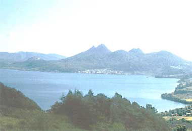
    Lake Toya is a caldera lake in the western part of Shikotsu-Toya National Park in southern Hokkaido. There are Toya Hot Springs and Usu Volcano Group on the southern shore. The lake is more or less circular in shape and has a group of islands at its centre. The bottom is covered by pyroclastic sediments.
    There are some 30 inflowing streams, but their discharge rates are very small except that of R. Horobetsu. R. Sibetsu is the sole outflowing river. Since 1937, however, R. Oru became a new outlet through the diversion of the lake water for hydroelectric power generation and flood control.
    The lake water became acidic since 1937 owing to the inflow of mining wastewater until pH 5 is reached around 1970, but the acidity has recently been improved to pH 6.8-7.0 after the neutralizing treatment in 1972.


C. PHYSICAL DIMENSIONS (Q)

    Surface area [km2] 70
    Volume [km3] 8.19
    Maximum depth [m] 179
    Mean depth [m] 116
    Water level Regulated
    Length of shoreline [km] 36
    Catchment area [km2] 173

D. PHYSIOGRAPHIC FEATURES

D1 GEOGRAPHICAL (Q)
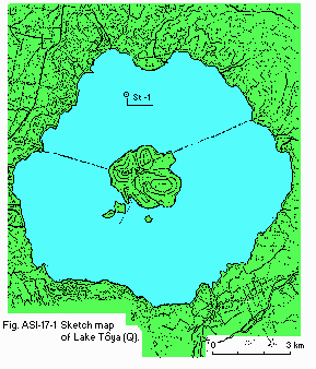
  • Sketch map: Fig. ASI-17-01.
  • Names of main islands: Naka-jima and Kannon-jima.
  • Number of outflowing rivers and channels (name)
    2 (Sobetsu R. and Water Intake).
D2 CLIMATIC (Q)
  • Climatic data at Otaki, 1982-1983
    Jan Feb Mar Apr May Jun Jul Aug Sep Oct Nov Dec Ann.
    Mean temp. [deg C] -6.9 -8.5 -3.2 4.1 9.6 11.8 16.5 19.6 13.8 6.7 1.7 4.9 5.8
    Precipitation [mm] 113 69 71 177 79 128 58 162 149 219 124 94 1,443

    Fig. ASI-17-01
    Sketch map of the lake (Q).

  • Water temperature [deg C]
    Station 1, 1981-1983
    Depth [m] Jan Feb Mar Apr May Jun Jul Aug Sep Oct Nov Dec
    0.5 - - - 4.7 7.8 14.4 22.4 - 20.8 15.2 - -
    5 - - - 4.2 7.3 11.8 19.7 - 20.5 14.7 - -
  • Freezing period: None.
  • Mixing type: Dimictic.

E. LAKE WATER QUALITY (Q)

E1 TRANSPARENCY [m]
    Station 1, 1981-1983
    Depth [m] Jan Feb Mar Apr May Jun Jul Aug Sep Oct Nov Dec
    - - - 10 11 13 20 - 13 8 - -
E2 pH
    Station 1, 1981-1983
    Depth [m] Jan Feb Mar Apr May Jun Jul Aug Sep Oct Nov Dec
    0.5 - - - 6.5 6.5 6.6 6.6 - 6.8 6.4 - -
    5 - - - 6.4 6.6 6.7 6.6 - 6.7 6.5 - -
E3 SS [mg l-1]
    Station 1, 1981-1983
    Depth [m] Jan Feb Mar Apr May Jun Jul Aug Sep Oct Nov Dec
    0.5 - - - <1.0 1.0 1.0 1.0 - 1.0 3.0 - -
    5 - - - 1.0 <1.0 1.0 <1.0 - 1.0 2.0 - -
E4 DO [mg l-1]
    Station 1, 1981-1983
    Depth [m] Jan Feb Mar Apr May Jun Jul Aug Sep Oct Nov Dec
    0.5 - - - 12 11 10 8.4 - 9.3 9.8 - -
    5 - - - 12 11 11 9.8 - 9.3 9.8 - -
E5 COD [mg l-1]
    Station 1, 1981-1983
    Depth [m] Jan Feb Mar Apr May Jun Jul Aug Sep Oct Nov Dec
    0.5 - - - <0.5 <0.5 <0.5 0.7 - 0.7 1.1 - -
    5 - - - <0.5 0.6 0.7 0.7 - 0.9 1.0 - -
E7 NITROGEN CONCENTRATION
  • Total-N [mg l-1]
    Station 1, 1981-1983
    Depth [m] Jan Feb Mar Apr May Jun Jul Aug Sep Oct Nov Dec
    0.5 - - - 0.32 0.29 0.33 0.30 - 0.37 0.28 - -
E8 PHOSPHORUS CONCENTRATION
  • Total-P [mg l-1]
    Station 1, 1981-1983
    Depth [m] Jan Feb Mar Apr May Jun Jul Aug Sep Oct Nov Dec
    0.5 - - - <.005 <.005 <.005 <.005 - <.005 <.005 - -

F. BIOLOGICAL FEATURES

F2 FAUNA
  • Fish
    Salmo nerka, Salmo mykiss, Zacco platypus, Cyprinus carpio, Carassius gibelio langsdorfi, Leuciscus (Tribolodon) ezoe, Hypomesus olidus.

G. SOCIO-ECONOMIC CONDITIONS

G1 LAND USE IN THE CATCHMENT AREA (Q)
    1983
    Area [km2] [%]
    Natural landscape
    - Woody vegetation 333.4 92.1
    Agricultural land 19.9 5.5
    Residential area 2.8 0.8
    Others 5.8 1.6
    Total 361.9 100.0

M. LEGISLATIVE AND INSTITUTIONAL MEASURES FOR UPGRADING LAKE ENVIRONMENTS

M1 NATIONAL AND LOCAL LAWS CONCERNED
    For national laws see "Biwa-ko".

N. SOURCES OF DATA

  1. Questionnaire filled by the Prefectural Government of Hokkaido.