
DONGTING-HU (LAKE DONGTING)
On the Yueyang Bay,East Lake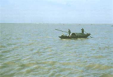
Photo: T. Kira
A. LOCATION
- Hunan Province, P.R. China.
- 28:30-30:20N, 111:40-113:10E; 33.5 m above sea level.
B. DESCRIPTION
-
Lake Dongting, in northeastern Hunan, is the second largest freshwater lake of China, with an extensive catchment area including the whole of Hunan and parts of the neighboring provinces, Hubei, Sichuan and Guizhou. It serves as a great retarding basin for the Chang Jiang (Yangtse River), from which flood water pours into the lake in July-September. The inflow from the Chang Jiang amounts to more than a half of the total water influx to L. Dongting, and carries with it a tremendous sediment load of 140,000,000 m3 yr-1 on average.
One hundred and fifty years ago, the lake was much bigger (6,200 km2) than it is now (2,740 km2), but the rapid progress of sedimentation and land reclamation works have since reduced its size, resulting in the formation of three more or less separate basins, West, South and East Dongting. In the summer flooding season, however, the three lakes unite into a single water body of about 3,900 km2 surface area. The water from the Chang Jiang flows mainly into the West and East Lake through three channels, and is drained from the northeastern corner of East Lake at Yueyang directly into the Chang Jiang again. The annual range of water level fluctuation in normal years ranges between 6.5 m (W. Lake) and 17.8 m (E. Lake).
The greatest environmental problem for L. Dongting is the rapid sedimentation fat a rate of ca. 5 cm yr-1 on a whole lake average) that causes trouble for surface transportation by boats, diminishes the lake's capacity for water storage and flood control, and affects fishery production through changes in the aquatic ecosystem. The Provincial Ordinance for Environmental Protection formulated in 1981, therefore, allows for no further reclamation work in or around the lake.
The heavy application of pesticides to rice fields as well as industrial development in recent years has caused local contamination of rivers and small attached lakes with BHC, heavy metals and organic wastes, but the main lake as a whole maintains fairly good water quality, with a mesotrophic nutrient level.
C. PHYSICAL DIMENSIONS
| Surface area [km2] | 2,740* |
| Volume [km3] | 17.8 |
| Maximum depth [m] | 30.8 |
| Mean depth [m] | 6.7 |
| Water level | Unregulated |
| Normal range of annual water | |
| level fluctuation [m] | 6.5-17.8 |
| Catchment area [km2] | 259,430 |
| * At the low water level. |
D. PHYSIOGRAPHIC FEATURES
D1 GEOGRAPHICAL- Sketch map: Fig. ASI-11-01.
- Names of main islands: None.
- Number of outflowing rivers and channels (name) Directly connected with the Chang Jiang (Yangtse R.) at Chenglingji in Yueyang.
- Climatic data at Yuanjiang, 1980-1982
| Jan | Feb | Mar | Apr | May | Jun | Jul | Aug | Sep | Oct | Nov | Dec | Ann. | |
|---|---|---|---|---|---|---|---|---|---|---|---|---|---|
| Mean temp. [deg C] | 4.5 | 5.7 | 10.3 | 16.2 | 22.3 | 25.0 | 28.8 | 27.2 | 22.5 | 18.0 | 18.2 | 7.3 | 16.7 |
| Precipitation [mm] | 77 | 78 | 176 | 149 | 162 | 170 | 123 | 177 | 48 | 91 | 116 | 11 | 1,369 |
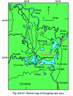
Sketch map of Dongting Lake area.
- Water temperature [deg C]
| Chenglingji, 1982 | ||||||||||||
| Depth [m] | Jan | Feb | Mar | Apr | May | Jun | Jul | Aug | Sep | Oct | Nov | Dec |
|---|---|---|---|---|---|---|---|---|---|---|---|---|
| 0.5 | 11 | 4 | 9.8 | 13.1 | 21.2 | 23.8 | 26.8 | 28.4 | 25.3 | 23.3 | 18.3 | 17.9 |
E. LAKE WATER QUALITY
E1 TRANSPARENCY [m]- NH4-N
- NO3-N
- Total-P [mg l-1]*
- Emerged macrophytes: Phragmites communis, Polygonum hydropiper, etc.
- Floating macrophytes: Lemna minor, Pistia stratiotes, etc.
- Submerged macrophytes: Vallisneria spiralis, Potamogeton crispus, etc.
- Phytoplankton: Chroococcus sp., Ceratium sp., etc.
- Fish
Coilia ectenes, Mylophoryngodon piceus, Ctenopharyngodon idellus, Hypophthalmichthys molitrix, Cyprinus carpio, Aristichthys nobilis, Megalobrama spp., Sinipera spp., Anguilla japonica, etc. (total number of fish species 114). - Phytoplankton: 48-164 [cell no ml-1].
- Zooplankton: 1.9-5.7 [cell no ml-1].
- Aquatic macrophytes: 66 [g m-2].
- Benthos: 78 [g m-2].
- Annual fish catch [metric tons]
- Main types of woody vegetation
Tree groves around villages (Pterocarya stenoptera, Salix babylonica, Cedrela sinensis, Populus canadensis, etc.); pine (Pinus massoniana) forest and plantations of pine and some other trees on low hills. - Main kinds of crops
Rice, cotton, ramie, jute, rapeseed, tobacco, sugar-cane, tea, citrus, mulberry, etc. - Rice, cotton, rapeseed oil, jute, ramie, etc.
- Machinery, electricity, chemicals, metal smelting, etc.
- Lead, zinc, antimony, tangsten and other metals, coal, etc.
- Nuisance caused by eutrophication: Not apparent.
- Municipal wastewater treatment systems
No. of secondary treatment systems: 1 (activated sludge,60,000 m3 day-1). - Names of the laws (the year of legislation)
- Environment Protection Law (1979, tentative)
- Ordinance for Environment Protection of Hunan Province (1981, tentative)
- Responsible authorities
- Bureau of Environment Protection, Ministry of Urban & Rural Construction and Environment Protection, National Government
- Managing Office for Environment Protection, Committee for Basic Construction and Environment Protection, Provincial Government of Hunan > Main items of control
- DO, pH, SS, COD, BOD, NH4-N, NO3-N, Hg, Cd, Pb, radioactive U, chlorinated hydrocarbons, etc.
- Research Institute for Environmental Science of Hunan Province, Changsha
| Chenglingji, 1982 | ||||||||||||
| Depth [m] | Jan | Feb | Mar | Apr | May | Jun | Jul | Aug | Sep | Oct | Nov | Dec |
| - | 0.24 | 0.25 | 0.12 | - | 0.16 | 0.11 | 0.21 | 0.20 | 0.24 | 0.22 | 0.26 | 0.26 |
| E2 pH | ||||||||||||
| Chenglingji, 1982 | ||||||||||||
| Depth [m] | Jan | Feb | Mar | Apr | May | Jun | Jul | Aug | Sep | Oct | Nov | Dec |
|---|---|---|---|---|---|---|---|---|---|---|---|---|
| 0.5 | 7.9 | 7.9 | 8.0 | 7.9 | 8.0 | 7.8 | 7.8 | 7.9 | 7.9 | 8.1 | 8.0 | 8.0 |
E4 DO [mg l-1]
| Chenglingji, 1982 | ||||||||||||
| Depth [m] | Jan | Feb | Mar | Apr | May | Jun | Jul | Aug | Sep | Oct | Nov | Dec |
|---|---|---|---|---|---|---|---|---|---|---|---|---|
| 0.5 | - | - | - | - | 7.7 | - | - | 7.9 | - | - | 8.4 | - |
E5 COD [mg l-1]
| Chenglingji, 1983 | ||||||||||||
| Depth [m] | Jan | Feb | Mar | Apr | May | Jun | Jul | Aug | Sep | Oct | Nov | Dec |
|---|---|---|---|---|---|---|---|---|---|---|---|---|
| 0.5 | 1.3 | 1.4 | 1.7 | 1.7 | 1.4 | 1.6 | 1.3 | 1.5 | 1.0 | 0.9 | 1.2 | 1.1 |
E7 NITROGEN CONCENTRATION [mg l-1]
| Chenglingji, 1983 | ||||||||||||
| Depth [m] | Jan | Feb | Mar | Apr | May | Jun | Jul | Aug | Sep | Oct | Nov | Dec |
|---|---|---|---|---|---|---|---|---|---|---|---|---|
| 0.5 | - | - | - | - | 0.12 | - | - | 0.38 | - | - | 0.3 | - |
| Depth [m] | Jan | Feb | Mar | Apr | May | Jun | Jul | Aug | Sep | Oct | Nov | Dec |
|---|---|---|---|---|---|---|---|---|---|---|---|---|
| 0.5 | - | - | - | - | 0.30 | - | - | 0.35 | - | - | 0.43 | - |
E8 PHOSPHORUS CONCENTRATION
| Chenglingji, 1982 | ||||||||||||
| Depth [m] | Jan | Feb | Mar | Apr | May | Jun | Jul | Aug | Sep | Oct | Nov | Dec |
|---|---|---|---|---|---|---|---|---|---|---|---|---|
| 0.5 | .001 | .004 | .000 | .005 | .003 | .001 | .000 | .000 | .002 | .000 | .005 | .000 |
F. BIOLOGICAL FEATURES
F1 FLORAF2 FAUNA
F4 BIOMASS
F5 FISHERY PRODUCTS
1981: ca. 70,000.
F7 NOTES ON THE REMARKABLE CHANGES OF BIOTA IN THE LAKE IN RECENT YEARS
-
Gradual decrease of economically important fish species and migratory fishes, and the increase of sedentary fishes.
G. SOCIO-ECONOMIC CONDITIONS
G1 LAND USE IN THE CATCHMENT AREA*| Area [km2] | [%] | |
|---|---|---|
| Natural landscape | ||
| Woody vegetation | 7,990 | 25.9 |
| Herbaceous vegetation | 2,120 | 6.9 |
| Swamp | 4,938 | 16.0 |
| Agricultural land | 8,900 | 28.8 |
| Residential area | 4,559 | 13.2 |
| Others | 2,837 | 9.2 |
| Total | 31,344 | 100.0 |
| 1982 | |||||
| Gross product during the year [yuan] | No of persons engaged | No. of establishments | Main products or | major industries | |
|---|---|---|---|---|---|
| Primary industry | 322,000 | 4,725,000 | N.A. | ||
| Agriculture | 230,000 | N.A. | N.A. | 1) | |
| Fisheries | 6,000 | N.A. | |||
| Others | 86,000 | N.A. | |||
| Secondary industry | 250,000 | 640,000 | 2,280 | ||
| Manufacturing | N.A. | N.A. | N.A. | 2) | |
| Mining | N.A. | N.A. | N.A. | 3) | |
| Tertiary industry | N.A. | N.A. | N.A. | ||
G3 POPULATION IN THE CATCHMENT AREA
| 1982 | |||
| Population | Population density [km-2] | Major cities (population) | |
|---|---|---|---|
| Total | 11,754,000 | 381.0? | Changsha (ca. 800,000), Yueyang. |
H. LAKE UTILIZATION
H1 LAKE UTILIZATION-
Source of water, fisheries, navigation (passengers 2-3 millions per year; cargo 15-19 million tons per year), tourism and recreation (swimming).
H2 THE LAKE AS WATER RESOURCE
-
Used as the sources of tap water in some cities and industrial water.
I. DETERIORATION OF LAKE ENVIRONMENTS AND HAZARDS
I3 EUTROPHICATIONJ. WASTEWATER TREATMENTS
J1 GENERATION OF POLLUTANTS IN THE CATCHMENT AREA-
d) Measurable pollution with limited wastewater treatment.
J3 SANITARY FACILITIES AND SEWERAGE
K. IMPROVEMENT WORKS IN THE LAKE
K3 OTHERS-
3.4 million tons of bottom sediments are annually dredged in the four main inflowing rivers and part of the lake. The improvement of the course of a river has reduced the influx of mud into the lake by 28,400,000 t yr-1. About 147 million trees have been planted for erosion control during the last 30 years.
M. LEGISLATIVE AND INSTITUTIONAL MEASURES FOR UPGRADING LAKE ENVIRONMENTS
M1 NATIONAL AND LOCAL LAWS CONCERNEDN. SOURCES OF DATA
-
All the data are based on the questionnaire filled by the Managing Office for Environment Protection, Provincial Government of Hunan. Some other information was also supplied from the Research Institute for Environmental Science of Hunan Province.
