
DANAU TOBA (LAKE TOBA)
A bird-eye view of the lake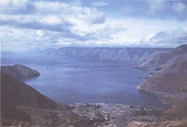
Photo: H. Haerumen Js
A. LOCATION
- North Sumatra Province, Indonesia.
- 2:21-2:56N, 98:26-99:15E; 905 m above sea level.
B. DESCRIPTION
-
Lake Toba lies in the northern part of Barisan Mountain Range, which is volcanic and traverses Sumatra Island from northwest to southeast as its backbone.
The laketrough is surrounded by precipitous cliffs 400-1,200 m high. Based on the topographic feature and the wide distribution of volcanic ejecta around the lake, some geologists and valcanologists have considered it to be a giant caldera or cauldron.
The water surface of L. Toba is 905 m above sea level and about 1,100 km2 wide. The total area of the lake, including the areas of Samosir and Paradapur Islands, amounts to 1,780 km2. The mountains around the lake are called Batak Highlands. The only draining river from L. Toba, the Asahan, flows southeastwards dissecting the gentle slopes of the pyroclastic plateau.
C. PHYSICAL DIMENSIONS (Q)
| Surface area [km2] | 1,100 |
| Volume [km3] | 1,258 |
| Maximum depth [m] | 529 |
| Water level | Unregulated |
| Normal range of annual water | |
| level fluctuation [m] | 1.5 |
| Catchment area [km2] | 3,440 |
D. PHYSIOGRAPHIC FEATURES (Q)
D1 GEOGRAPHICAL- Sketch map: Fig. ASI-10-01.
- Names of main islands: Samosir (640 km2) and Paradapur (7 km2).
- Number of outflowing rivers and channels (name): 1 (Asahan R.).
- Climatic data at Parparean, 1961-1980
| Jan | Feb | Mar | Apr | May | Jun | Jul | Aug | Sep | Oct | Nov | Dec | Ann. | |
|---|---|---|---|---|---|---|---|---|---|---|---|---|---|
| Mean temp. [deg C] | 19.3 | 19.0 | 18.9 | 19.3 | 19.4 | 19.1 | 19.0 | 18.8 | 19.0 | 19.4 | 19.4 | 19.1 | 19.1 |
| Precipitation [mm] | 100 | 105 | 115 | 132 | 124 | 102 | 83 | 110 | 148 | 174 | 182 | 178 | 1,732 |
- Solar radiation: 15.7 MJ m-2 day-1.
- Water temperature [deg C]
| Station | Surface |
|---|---|
| Haranggaul | 27 |
| Tigaras | 27 |
| Tomok | 26 |
| Simanindo | 27 |
| Pangururan | 27 |
| Nainggolan | 27 |
| Prapat | 27 |
| Porsea | 26 |
- Freezing period: None.
- Notes on water mixing and thermocline formation
Mizuno observed an extremely homogeneous vertical distribution of water temperature from the surface down to 300 m depth on 23 January 1976 (13).
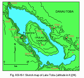
Sketch map (altitude in ft)(14).
E. LAKE WATER QUALITY (Q)
E2 pH, 1979| Station | Surface |
|---|---|
| Lotung | 8.4 |
| Situmeang | 7.9 |
| Bukit | 8.4 |
| Tongging I | 7.0 |
| Tongging II | 7.9 |
| Onan Runggu | 7.6 |
| Prapat | 8.2 |
| Station | Surface |
|---|---|
| Lotung | 6.7 |
| Situmeang | 6.8 |
| Bukit | 9.3 |
| Tongging I | 6.3 |
| Tongging II | 7.0 |
| Onan Runggu | 7.0 |
| Prapat | 8.0 |
| Determined by KMnO4 method. | |
| Station | Surface |
|---|---|
| Haranggaul | 2.30 |
| Prapat | 2.80 |
| Mogang | 2.24 |
| Onan Runggu | 2.15 |
| Porsea | 2.06 |
| Hashinggahan | 1.30 |
| Tomok | 1.53 |
| Sabulan | 1.72 |
| Muara | 1.36 |
| Balige | 1.24 |
- Total-P [mg l-1], 1979
| Station | Surface |
|---|---|
| Haranggaul | 0.31 |
| Hasinggahan | 0.32 |
| Tomok | 0.66 |
| Station | Surface |
|---|---|
| Haranggaul | 8.6 |
| Prapat | 8.3 |
| Mogang | 10.1 |
| Onan Runggu | 10.4 |
| Porsea | 10.3 |
| Hasinggahan | 11.8 |
| Tomok | 11.0 |
| Sabulan | 9.2 |
| Muara | 9.6 |
| Balige | 9.5 |
F. BIOLOGICAL FEATURES (Q)
F1 FLORA- Emerged macrophytes: Nelumbo nucifera, Nymphaea sp.
- Floating macrophytes:Eichhornia crassipes, Lemna minor, Azolla pinnata, Spirodella polyrhiza.
- Submerged macrophytes:Potamogeton malaianus, P. polygonifolius, Myriophyllum spicatum, Ceratophyllum demersum, Hydrilla verticillata, Chara sp.
- Phytoplankton:Amphora, Cocconema, Asterionella, Synedra, Gomphonema, Orthosira, Navicula,Mastogloia, Pleurosigma, Nitzschia, Genicularia, Botryococcus, Synechococcus,Anabaena, Oscillatoria.
- Zooplankton: Cyclops, Cladocera.
- Benthos: Macrobrachium sintangensis, Brotia costula, Thiara scabra, Melanoidestuberculata, Melanoides granifera, Anentome helena, Lymnaea brevispira, L.rubiginosa, Physastra sumatrana, Corbicula tobae.
- Fish: Tilapia mossambica, Aplocheilus pachax, Lebistes reticulatus, Osphronemus goramy, Trichogaster trichopterus, Channa striata, C. gachua, Clarias batrachus, C. nieuhofi, C. sp., Nemachilus fasciatus, Cyprinus carpio, Puntius javanicus, P. binotatus, Osteochilus nasselti, Lissochilus sp., Labeobarbus sora, Rasbora sp.
- Submerged macrophytes [g (wet wt.) m-2]
| Station | Potamogeton sp. | Myriophyllum spicatum | Others | Total |
|---|---|---|---|---|
| Lotung | 2,470 | 130 | <25 | 2,600 |
| Onan Runggu | 2.800 | 150 | 0 | 2,950 |
| Parbaloan Urat | 1,833 | 310 | 520 | 2,663 |
| Tongging | 1,947 | 157 | <25 | 2,104 |
| Lumban Sitorus | 150 | 1,640 | 0 | 1,750 |
- Annual fish catch [metric tons]
1978: 2,820.
- Annual fish catch [metric ton]
| Year | Production | |||
|---|---|---|---|---|
| Tilapia mossambica | Cyprinus carpio | Others | Total | |
| 1967 | 1,039 | 207.8 | 831.2 | 2,078 |
| 1976 | - | - | - | 2,211 |
| 1977 | - | - | - | 2,569 |
| 1978 | 2,175.1 | 4.6 | 640.2 | 2,820 |
-
Increasing: Tilapia mossambica. Decreasing: Cyprinus carpio.
G. SOCIO-ECONOMIC CONDITIONS (Q)
G1 LAND USE IN THE CATCHMENT AREA| 1981 | ||
| Area [km2] | [%] | |
|---|---|---|
| Natural landscape | ||
| Grass (alang-alang) | 955 | 40.6 |
| Scrub | 59.24 | 2.5 |
| Forest | 159.66 | 6.8 |
| Reforestation | 388.70 | 16.6 |
| Regreening | 228.28 | 9.7 |
| Agricultural land | 512.08 | 21.8 |
| Plantation | 20.88 | 0.9 |
| Others | 23.56 | 1.1 |
| Total | 2,347.50 | 100 |
- Main types of woody vegetation:Tropical high mountain forest; Pinus merkusii forest; Macadamia hildebrandii
forest. - Main types of herbaceous vegetation:Imperata cylindrica with Rhodomyrtus tomentos, Melastoma sp. and Gleichenia linearis.
- Main kinds of crops: Rice, sweet potato, maize, vegetables.
- Levels of fertilizer application on crop fields: Moderate.
-
No information.
G3 POPULATION IN THE CATCHMENT AREA
| 1980 | ||||
| District | Area[km2] | Population | Family | Population density [km-2] |
|---|---|---|---|---|
| Tapanuli Utara | 2,420.5 | 309,111 | 66,744 | 128 |
| Tanah Karo | 63.0 | 3,901 | 731 | 62 |
| Dairi | 45.0 | 9,011 | 1,810 | 200 |
| Total | 2,528.5 | 322,023 | 69,285 | 127 |
H. LAKE UTILIZATION
H1 LAKE UTILIZATION (Q)-
Source of water, navigation and transportation (amount of cargo in 1978: 1,922
metric tons), sightseeing and tourism (no. of visitors in 1978: 44,625).
recreation (yachting), fisheries.
H2 THE LAKE AS WATER RESOURCE : No information.
I. DETERIORATION OF LAKE ENVIRONMENTS AND HAZARDS (Q)
I1 ENHANCED SILTATION- Extent of damage: Not serious.
I3 EUTROPHICATION: No information.
I4 ACIDIFICATION
- Extent of damage: None.
J. WASTEWATER TREATMENTS (Q)
J1 GENERATION OF POLLUTANTS IN THE CATCHMENT AREA-
f) Measurable pollution without wastewater treatment.
- Percentage of municipal population in the catchment area provided with adequate sanitary facilities (on-site treatment system) or public sewerage: None.
- Percentage of rural population with adequate sanitary facilities (on-site treatment systems): None.
- Municipal wastewater treatment systems: None.
- Industrial wastewater treatment systems: None.
K. IMPROVEMENT WORKS IN THE LAKE
-
None.
L. DEVELOPMENT PLANS (Q)
- Integrated management on Toba Lake catchment area.
- Hydroelectric power plant under construction.
M. LEGISLATIVE AND INSTITUTIONAL MEASURES FOR UPGRADING LAKE ENVIRONMENTS (Q)
M1 NATIONAL AND LOCAL LAWS CONCERNED- Names of the laws (the year of legislation)
- Act of the Republic of Indonesia No 4 concerning Basic Provisions for the Management of the Living Environment (1982)
- State Regulation of the Republic of Indonesia No.29 on Environmental Impact Assessment (1986)
- Responsible authorities
- & (2) The State Minister for Population and Environment. Ministry of Home Affairs, Ministry of Public Works, Ministry of Forestry and Local (Provincial) Governments
- The State Minister for Population and Environment responsible for coordinating environmental managements
- Ministry of Public Works responsible for lake utilization
- Ministry of Home affairs responsible for regional development
- Ministry of Forestry responsible for forest management and soil conservation
- Centre of Environmental Studies (University)
- Institute of Hydraulic Engineering Agency of Resources and Development
N. SOURCES OF DATA
- Questionnaire filled by Dr. Herman Haerumen is, Ministry of State for Popula tion and Environment, Indonesia, based on the following literature (1)-(12).
- Abdullah Angaedi (1980) Studi Perencanaan Perbaikan Keadaan Danau Toba,Suma tra Utara, PT. Indah Karya & Ministry of Public Works.
- Asahan Development Authority (1984) Laporan Penyelesaian Pelaksanaan Pemban gunan Proyek Asahan.
- Directorate of Forest Planning & Programme (1981) Pola Pengelolaan Catchmen t Area Danau Toba, Sumatra Utara. Ministry of Agriculture.
- Hehanussa P. E. (1982) Tefra Toba. National Geology & Mining Institute. Na tional Institute of Sciences.
- --- (1982) Penanggalan Radiometri Formasi Samosir Tefra Toba.National Geology & Mining Institute, National Institute of Sciences.
- --- (1983) Tefra Toba disekitar Danau Toba, Sumatra Utara.National Geology & Mining Institute, National Institute of Sciences.
- ---, Fujii, S. & Yokoyama, T. (1983) New dates of fluvio-iacustrine deposits from Lake Toba, Indonesia.
- Ibnu Fajar (1983) Laporan Penyelidikan Geologi Lingkungan Daerah Tadah Danau Toba, Sumatra Utara. Directorate of Environmental Planning of Geology.
- --- (1984) Laporan Penyelidikan Geologi Tata Lingkungan Daerah Aliran Sungai Asahan, Sumatra Utara. Directorate of Environmental Planning of Geology.
- University of Indonesia & Ministry of Public Works (1979) Survai Ekologi Danau Toba.
- University of Sumatra Utara & The Office of State Minister for Development Supervision & Environment (1979) Komunitas, Lingkungan Perairan & Kehidupan Biologis Danau Toba, Sumatra Utara.
- Yusron Loebis (1982) Penelitian Keseimbangan Tata Air Danau Toba.Institute of Hydraulic Engineering, Ministry of Public Works.
- Mizuno, T. (1977) Water temperature and some other environmental factors in inland waters of tropical Asia. Suion no Kenkyu, 21 (1): 12-19 (in Japanese).
- --- (1980) Lakes and Forests of Tropical Asia. 232 pp. Tokai Univ. Press, Tokyo (in Japanese).
