
RESERVOIR KUJBYSHEVSKOE
A view on the lakeshore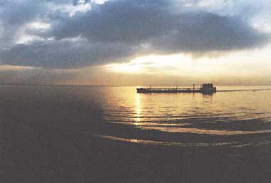
Photo: L.A.Vyhrystiuk
A. LOCATION
- Mari ASSR, Chuvash ASSR, Tatar ASSR, Ulianovsk Region and Samara Region,
Russia. - 56:10-53:20N, 47:30-51:30E; 53 m above sea level.
B. DESCRIPTION
-
Reservoir Kujbyshevskoe on the River Volga is the largest riverine water body in Europe and is one of the most important components of the Volga-Kama cascade of reservoirs. Its dam (Volzhskaya Dam) was built near the city of Zhiguliovsk in accordance with the scheme made by the Institute of Hydroproject. The construction of this reservoir was began in October 1955 and completed in May 1957. This multi-purpose artificial water body carries out seasonal, week by and daily regulations of the flows of the Volga. Water discharged through Volzhskaya Dam flows into the Reservoir Saratovskoe which is the next stair in the Volga-Kama cascade.
The reservoir is located in the eastern part of Russian Plain. The middle course of the Volga where the reservoir is situated was formed several million years ago in Pliocene, and was flooded by the water of Paleo-Caspian Sea during its transgression period.
The reservoir is more than 400 km long, and consists of several sections or reaches, of which the largest is Cheremshan Bay with a water volume of more than 1 km3. There are many inlets near inflowing river mouths. The right (western) bank is high (up to 300 m) and steep. The submerged bed of the Volga runs near the right bank, forming a zone of maximum depth.
Major tributaries are the Rivers Viatka, Sviyagha and Bolshoy Cheremshan. Ninety-nine percent of the total inflowing water come from surface runoff, precipitation on the reservoir surface accounting for only 1%. On an average, the Volga contributes 43%, the R. Kama 38%, and the R. Viatka 11% of the total water influx. The input of the Volga water to the reservoir is controlled by six upstream dams and that of the Kama by three other dams.
The climate of the region is temperate, continental and transitional from humid to semi-arid climate. The northern part of the reservoir is in the forest zone, while its southern part belongs to the forest-steppe region. After the reservoir formation, daily mean temperature in the coastal area became lower by 1.5deg C in spring, and rose by more than 2deg C in autumn.
There are a lot of cities and towns along the shore of the reservoir. Some of them such as Kazan, Ulianovsk and Tolyatty have grown into large industrial centers of the country. Irrigated lands are widely developed in the catchment area. The growth of productivity in this region is associated with the increase of water use, which, however, negatively affects the environment and sanitary condition of the reservoir's water resources in turn (1, 2, 3, 4, 5, 6).
C. PHYSICAL DIMENSIONS (1)
| Surface area [km2] | 5,900 |
| Volume [km3] | 58 |
| Maximum depth [m] | 41 |
| Mean depth [m] | 9.8 |
| Water level | Regulated |
| Normal range of annual water level fluctuation [m] | 4-6 |
| Length of shoreline [km] | 2,500 |
| Residence time [yr] | 0.24 |
| Catchment area [km2] | 1,200,000 |
D. PHYSIOGRAPHIC FEATURES
D1 GEOGRAPHICAL- Sketch map: Fig. EUR-54-1.
- Bathymetric map: Fig. EUR-54-2.
- Number of main islands (name and area): Sedelnikovsky (Reach I), Kreushinsky
(I), Sviyazhsky (I), Banny (VI), Dalnaya Dubrava (VII), Khryaschevsky (VIII). - Number of outflowing rivers and channels (name): 1 (R. Volga).
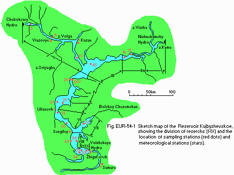
Sketch map of the reservoir, showing the division of reaches (I IX) and the location of sampling stations (black dots) and meteorological stations (stars).
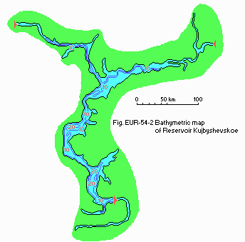
Bathymetric map [m].
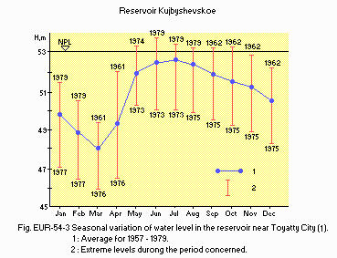
Seasonal variation of water level in the reservoir near Tolyatty City (1).
D2 CLIMATIC
- Climatic data at Kazan, 1925 1980 (7, 8)
| Jan | Feb | Mar | Apr | May | Jun | Jul | Aug | Sep | Oct | Nov | Dec | Ann. | |
|---|---|---|---|---|---|---|---|---|---|---|---|---|---|
| Mean temp. [deg C] | -13.5 | -13.1 | -6.5 | 3.7 | 12.4 | 17.0 | 19.1 | 17.5 | 11.2 | 3.4 | -3.8 | -10.4 | 3.1 |
| Precipitation [mm] | 24 | 22 | 22 | 32 | 42 | 63 | 68 | 64 | 52 | 52 | 37 | 30 | 508 |
- Sengiley, 1925 1980 (7, 8)
| Jan | Feb | Mar | Apr | May | Jun | Jul | Aug | Sep | Oct | Nov | Dec | Ann. | |
|---|---|---|---|---|---|---|---|---|---|---|---|---|---|
| Mean temp. [deg C] | -13.2 | -12.5 | -6.1 | 4.8 | 13.0 | 17.1 | 18.7 | 17.2 | 11.3 | 3.6 | -3.1 | -8.9 | 3.5 |
| Precipitation [mm] | 26 | 21 | 25 | 30 | 41 | 52 | 57 | 55 | 43 | 43 | 34 | 30 | 457 |
- Number of hours of bright sunshine [hr yr-1](1955 1980)
1,899 at Viazovie and 2,112 at Samara. - Solar radiation [MJ m-2 day 1]
10.6 at Viazovie (1952 1980) and 11.6 at Samara (1958 1980). - Water temperature [deg C], 1967 1980 (1)
| Reach I | ||||||||||||
| Depth [m] | Jan | Feb | Mar | Apr | May | Jun | Jul | Aug | Sep | Oct | Nov | Dec |
|---|---|---|---|---|---|---|---|---|---|---|---|---|
| 0.5 | - | - | - | - | 12.1 | 17.4 | 20.7 | 21.0 | 16.5 | 8.9 | 5.6 | - |
| B* | - | - | - | - | 12.0 | 12.5 | 20.2 | 20.9 | 16.4 | 8.4 | 5.1 | - |
| Reach II | ||||||||||||
| Depth [m] | Jan | Feb | Mar | Apr | May | Jun | Jul | Aug | Sep | Oct | Nov | Dec |
|---|---|---|---|---|---|---|---|---|---|---|---|---|
| 0.5 | - | - | - | - | 10.5 | 16.9 | 21.4 | 21.0 | 15.3 | 8.0 | 3.3 | - |
| B* | - | - | - | - | 10.5 | 15.4 | 20.6 | 19.9 | 15.1 | 7.7 | 3.5 | - |
| Reach III | ||||||||||||
| Depth [m] | Jan | Feb | Mar | Apr | May | Jun | Jul | Aug | Sep | Oct | Nov | Dec |
|---|---|---|---|---|---|---|---|---|---|---|---|---|
| 0.5 | - | - | - | - | 10.8 | 17.2 | 21.1 | 20.6 | 15.8 | 8.1 | 4.9 | - |
| B* | - | - | - | - | 10.1 | 15.8 | 19.2 | 20.1 | 15.7 | 8.0 | 4.9 | - |
| Reach IV | ||||||||||||
| Depth [m] | Jan | Feb | Mar | Apr | May | Jun | Jul | Aug | Sep | Oct | Nov | Dec |
|---|---|---|---|---|---|---|---|---|---|---|---|---|
| 0.5 | - | - | - | - | 11.1 | 17.4 | 21.1 | 21.0 | 16.4 | 9.0 | 4.8 | - |
| B* | - | - | - | - | 10.7 | 16.6 | 19.6 | 20.2 | 15.8 | 8.9 | 5.0 | - |
| Reach V | ||||||||||||
| Depth [m] | Jan | Feb | Mar | Apr | May | Jun | Jul | Aug | Sep | Oct | Nov | Dec |
|---|---|---|---|---|---|---|---|---|---|---|---|---|
| 0.5 | - | - | - | - | 10.8 | 18.4 | 20.7 | 21.2 | 16.8 | 9.8 | 6.0 | - |
| B* | - | - | - | - | 9.7 | 15.3 | 18.1 | 20.1 | 16.5 | 9.8 | 6.0 | - |
| Reach VI | ||||||||||||
| Depth [m] | Jan | Feb | Mar | Apr | May | Jun | Jul | Aug | Sep | Oct | Nov | Dec |
|---|---|---|---|---|---|---|---|---|---|---|---|---|
| 0.5 | - | - | - | - | 10.1 | 17.7 | 20.9 | 21.0 | 16.9 | 10.6 | - | - |
| B* | - | - | - | - | 9.8 | 15.5 | 19.6 | 19.6 | 16.7 | 9.8 | - | - |
| Reach VII | ||||||||||||
| Depth [m] | Jan | Feb | Mar | Apr | May | Jun | Jul | Aug | Sep | Oct | Nov | Dec |
|---|---|---|---|---|---|---|---|---|---|---|---|---|
| 0.5 | - | - | - | - | 16.7 | 18.4 | 21.2 | 21.5 | 17.5 | 11.2 | 3.2 | - |
| B* | - | - | - | - | 9.2 | 15.3 | 17.5 | 19.3 | 17.0 | 11.1 | 3.3 | - |
| Reach VIII | ||||||||||||
| Depth [m] | Jan | Feb | Mar | Apr | May | Jun | Jul | Aug | Sep | Oct | Nov | Dec |
|---|---|---|---|---|---|---|---|---|---|---|---|---|
| 0.5 | - | - | - | - | 9.6 | 17.9 | 20.6 | 21.1 | 17.3 | 11.4 | 6.1 | - |
| B* | - | - | - | - | 7.9 | 14.1 | 16.9 | 19.0 | 17.2 | 11.5 | - | - |
| Reach IX | ||||||||||||
| Depth [m] | Jan | Feb | Mar | Apr | May | Jun | Jul | Aug | Sep | Oct | Nov | Dec |
|---|---|---|---|---|---|---|---|---|---|---|---|---|
| 0.5 | - | - | - | - | 11.8 | 18.1 | 21.8 | 20.9 | 15.7 | 8.7 | 6.9 | - |
| B* | - | - | - | - | 9.4 | 15.5 | 18.7 | 19.7 | 15.5 | 8.6 | - | - |
- Freezing period
From 4 November to 27 April at Viazovie and from 22 November to 27 April at Tolyatty (1957 1980). - Mixing type: Polymictic.
- Notes on water mixing and thermocline formation
In the calm weather of summer heating period (May August), temporary thermocline tends to be formed more sharply in less flowing Reaches VII, VIII and IX. When wind-induced mixing takes place for several days, the thermocline is destroyed and vertical isothermy is established over the whole reservoir. In winter, inverse thermal stratification occurs under ice cover in these reaches, owing to the heat accumulation near the bottom. This heat is transferred from reservoir bed to water through the winter (1, 4).
E. LAKE WATER QUALITY
E1 TRANSPARENCY [m](8) (1981-1985)| Station | Jan | Feb | Mar | Apr | May | Jun | Jul | Aug | Sep | Oct | Nov | Dec |
|---|---|---|---|---|---|---|---|---|---|---|---|---|
| 8 | - | - | - | - | 0.9 | 1.2 | 1.4 | 1.3 | 1.5 | 1.6 | - | - |
| 21 | - | - | - | - | 0.7 | 1.0 | 1.4 | 1.0 | 1.0 | 0.9 | - | - |
| 34 | - | - | - | - | 0.9 | 1.3 | 1.9 | 1.7 | 1.7 | 1.8 | - | - |
| 34 | - | - | - | - | 1.2 | 1.5 | 1.7 | 1.4 | 1.9 | 1.5 | - | - |
| Station 8, 1981-1985 | ||||||||||||
| Depth [m] | Jan | Feb | Mar | Apr | May | Jun | Jul | Aug | Sep | Oct | Nov | Dec |
|---|---|---|---|---|---|---|---|---|---|---|---|---|
| 0.5 | - | - | - | - | 7.3 | 7.6 | 7.6 | 7.7 | 7.6 | 7.6 | - | - |
| Station 21, 1981-1985 | ||||||||||||
| Depth [m] | Jan | Feb | Mar | Apr | May | Jun | Jul | Aug | Sep | Oct | Nov | Dec |
|---|---|---|---|---|---|---|---|---|---|---|---|---|
| 0.5 | - | - | - | - | 7.5 | 7.9 | 8.5 | 7.6 | 7.8 | 7.8 | - | - |
| 29 | - | - | - | - | 7.5 | 7.8 | 7.6 | 7.6 | 7.8 | 7.8 | - | - |
| Station 34, 1981-1985 | ||||||||||||
| Depth [m] | Jan | Feb | Mar | Apr | May | Jun | Jul | Aug | Sep | Oct | Nov | Dec |
|---|---|---|---|---|---|---|---|---|---|---|---|---|
| 0.5 | - | - | - | - | 7.5 | 7.5 | 8.4 | 7.9 | 8.0 | 7.6 | - | - |
| 34 | - | - | - | - | 7.5 | 7.5 | 7.4 | 7.6 | 7.8 | 7.8 | - | - |
| Station 34, 1990 | ||||||||||||
| Depth [m] | Jan | Feb | Mar | Apr | May | Jun | Jul | Aug | Sep | Oct | Nov | Dec |
|---|---|---|---|---|---|---|---|---|---|---|---|---|
| 0.5 | - | - | - | - | 8.31 | 8.18 | 8.36 | 8.22 | 8.05 | 8.15 | - | - |
| 34 | - | - | - | - | 8.29 | 8.18 | 7.98 | 7.82 | 8.05 | 8.22 | - | - |
| Station 34, 1989 | ||||||||||||
| Depth [m] | Jan | Feb | Mar | Apr | May | Jun | Jul | Aug | Sep | Oct | Nov | Dec |
|---|---|---|---|---|---|---|---|---|---|---|---|---|
| 0.5 | - | - | - | - | 9.5 | 35.8 | 14.3 | 17.8 | 16.3 | 11.0 | - | - |
| 34 | - | - | - | - | 24.3 | 29.0 | 17.0 | 24.0 | 15.0 | 11.5 | - | - |
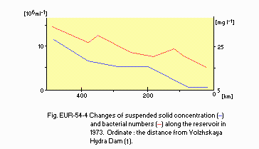
Changes of suspended solid concentration (1) and bacterial numbers (2) along the reservoir in 1973. Ordinate: the distance from Volzhskaya Hydro Dam (1).
E4 DO [mg l-1](8)
| Station 8, 1981-1985 | ||||||||||||
| Depth [m] | Jan | Feb | Mar | Apr | May | Jun | Jul | Aug | Sep | Oct | Nov | Dec |
|---|---|---|---|---|---|---|---|---|---|---|---|---|
| 0.5 | - | - | - | - | 9.7 | 7.4 | 7.8 | 7.1 | 8.1 | 10.1 | - | - |
| Station 21, 1981-1985 | ||||||||||||
| Depth [m] | Jan | Feb | Mar | Apr | May | Jun | Jul | Aug | Sep | Oct | Nov | Dec |
|---|---|---|---|---|---|---|---|---|---|---|---|---|
| 0.5 | - | - | - | - | 10.5 | 7.8 | 10.6 | 9.6 | 8.8 | 10.7 | - | - |
| 34 | - | - | - | - | 10.9 | 6.9 | 4.9 | 7.2 | 8.2 | 10.9 | - | - |
| Station 34, 1981-1985 | ||||||||||||
| Depth [m] | Jan | Feb | Mar | Apr | May | Jun | Jul | Aug | Sep | Oct | Nov | Dec |
|---|---|---|---|---|---|---|---|---|---|---|---|---|
| 0.5 | - | - | - | - | 9.9 | 10.2 | 9.1 | 8.3 | 8.9 | 10.2 | - | - |
| 34 | - | - | - | - | 9.4 | 7.8 | 5.4 | 3.9 | 7.9 | 10.3 | - | - |
| Station 34, 1990 | ||||||||||||
| Depth [m] | Jan | Feb | Mar | Apr | May | Jun | Jul | Aug | Sep | Oct | Nov | Dec |
|---|---|---|---|---|---|---|---|---|---|---|---|---|
| 0.5 | - | - | - | - | 12.0 | 9.1 | 7.6 | 8.7 | 9.1 | 10.2 | - | - |
| 34 | - | - | - | - | 10.2 | 8.6 | 4.2 | 6.2 | 8.4 | 10.1 | - | - |
- Determined by K2Cr2O7 method.
| Station 8, 1981-1985 | ||||||||||||
| Depth [m] | Jan | Feb | Mar | Apr | May | Jun | Jul | Aug | Sep | Oct | Nov | Dec |
|---|---|---|---|---|---|---|---|---|---|---|---|---|
| 0.5 | - | - | - | - | 23.4 | 25.9 | 23.1 | 24.7 | 25.8 | 21.9 | - | - |
| Station 21, 1981-1985 | ||||||||||||
| Depth [m] | Jan | Feb | Mar | Apr | May | Jun | Jul | Aug | Sep | Oct | Nov | Dec |
|---|---|---|---|---|---|---|---|---|---|---|---|---|
| 0.5 | - | - | - | - | 20.0 | 22.1 | 25.6 | 21.0 | 22.4 | 24.5 | - | - |
| 34 | - | - | - | - | 21.1 | 25.8 | 27.5 | 21.8 | 21.9 | 22.6 | - | - |
| Station 34, 1981-1985 | ||||||||||||
| Depth [m] | Jan | Feb | Mar | Apr | May | Jun | Jul | Aug | Sep | Oct | Nov | Dec |
|---|---|---|---|---|---|---|---|---|---|---|---|---|
| 0.5 | - | - | - | - | 25.0 | 23.5 | 25.0 | 26.7 | 24.0 | 23.6 | - | - |
| 34 | - | - | - | - | 25.2 | 23.4 | 24.4 | 21.8 | 24.3 | 25.0 | - | - |
| Station 34, 1990 | ||||||||||||
| Depth [m] | Jan | Feb | Mar | Apr | May | Jun | Jul | Aug | Sep | Oct | Nov | Dec |
|---|---|---|---|---|---|---|---|---|---|---|---|---|
| 0.5 | - | - | - | - | 24.3 | 24.5 | 29.4 | 30.7 | 20.0 | 21.2 | - | - |
| 34 | - | - | - | - | 24.7 | 22.8 | 22.2 | 21.0 | 21.2 | 20.2 | - | - |
| Station 34, 1989 | ||||||||||||
| Depth [m] | Jan | Feb | Mar | Apr | May | Jun | Jul | Aug | Sep | Oct | Nov | Dec |
|---|---|---|---|---|---|---|---|---|---|---|---|---|
| 0.5 | - | - | - | - | 12.6 | 13.3 | 12.6 | 39.7 | 8.8 | 12.5 | 5.9 | - |
| 34 | - | - | - | - | 11.9 | 10.6 | 4.0 | 6.3 | 13.5 | 19.6 | 4.9 | - |
| Station 34, 1990 | ||||||||||||
| Depth [m] | Jan | Feb | Mar | Apr | May | Jun | Jul | Aug | Sep | Oct | Nov | Dec |
|---|---|---|---|---|---|---|---|---|---|---|---|---|
| 0.5 | - | - | - | - | 7.5 | 5.5 | 50.4 | 14.6 | 14.3 | 3.2 | 9.4 | - |
| 34 | - | - | - | - | 9.7 | 3.9 | 21.8 | 2.8 | 2.5 | 3.0 | 9.5 | - |
| Station 39, 1989 | ||||||||||||
| Depth [m] | Jan | Feb | Mar | Apr | May | Jun | Jul | Aug | Sep | Oct | Nov | Dec |
|---|---|---|---|---|---|---|---|---|---|---|---|---|
| 0.5 | 1.6 | 0.3 | 0.3 | - | 18.6 | 15.0 | 23.3 | 44.8 | 18.5 | 19.2 | 8.9 | - |
| 9 | 1.6 | 0.3 | 0.0 | - | 14.6 | 8.3 | 10.3 | 8.2 | 11.5 | 19.2 | 8.9 | - |
| Station 39, 1990 | ||||||||||||
| Depth [m] | Jan | Feb | Mar | Apr | May | Jun | Jul | Aug | Sep | Oct | Nov | Dec |
|---|---|---|---|---|---|---|---|---|---|---|---|---|
| 0.5 | - | - | - | - | 22.5 | 3.6 | 6.5 | 18.5 | 10.2 | 4.1 | 10.7 | - |
| 9 | - | - | - | - | 19.8 | 4.2 | 5.5 | 5.1 | 6.4 | 3.9 | 10.7 | - |
- Total-N [mg l-1]
| Station 8, 1981-1985 | ||||||||||||
| Depth [m] | Jan | Feb | Mar | Apr | May | Jun | Jul | Aug | Sep | Oct | Nov | Dec |
|---|---|---|---|---|---|---|---|---|---|---|---|---|
| 0.5 | - | - | - | - | 0.90 | 1.01 | 0.74 | 1.18 | 1.24 | 1.22 | - | - |
| Station 21, 1981-1985 | ||||||||||||
| Depth [m] | Jan | Feb | Mar | Apr | May | Jun | Jul | Aug | Sep | Oct | Nov | Dec |
|---|---|---|---|---|---|---|---|---|---|---|---|---|
| 0.5 | - | - | - | - | 1.56 | 1.27 | 1.38 | 0.64 | 0.84 | 0.91 | - | - |
| Station 34, 1981-1985 | ||||||||||||
| Depth [m] | Jan | Feb | Mar | Apr | May | Jun | Jul | Aug | Sep | Oct | Nov | Dec |
|---|---|---|---|---|---|---|---|---|---|---|---|---|
| 0.5 | - | - | - | - | 1.60 | 1.06 | 0.82 | 0.92 | 0.88 | 0.92 | - | - |
| Station 34, 1990 | ||||||||||||
| Depth [m] | Jan | Feb | Mar | Apr | May | Jun | Jul | Aug | Sep | Oct | Nov | Dec |
|---|---|---|---|---|---|---|---|---|---|---|---|---|
| 0.5 | - | - | - | - | 1.67 | 1.24 | 1.35 | 1.07 | 1.01 | 1.43 | - | - |
| 34 | - | - | - | - | 1.63 | 1.05 | 0.77 | 1.17 | 0.93 | 1.07 | - | - |
- Particulate-N [mg l-1]
| Station 34, 1989 | ||||||||||||
| Depth [m] | Jan | Feb | Mar | Apr | May | Jun | Jul | Aug | Sep | Oct | Nov | Dec |
|---|---|---|---|---|---|---|---|---|---|---|---|---|
| 0.5 | - | - | - | - | 0.02 | 0.07 | 0.10 | 0.11 | 0.11 | trace | - | - |
| 34 | - | - | - | - | 0.26 | 0.09 | 0.03 | 0.02 | 0.07 | trace | - | - |
- Total-P [micro l-1]
| Station 8, 1981-1985 | ||||||||||||
| Depth [m] | Jan | Feb | Mar | Apr | May | Jun | Jul | Aug | Sep | Oct | Nov | Dec |
|---|---|---|---|---|---|---|---|---|---|---|---|---|
| 0.5 | - | - | - | - | 116 | 95 | 99 | 131 | 96 | 100 | - | - |
| Station 21, 1981-1985 | ||||||||||||
| Depth [m] | Jan | Feb | Mar | Apr | May | Jun | Jul | Aug | Sep | Oct | Nov | Dec |
|---|---|---|---|---|---|---|---|---|---|---|---|---|
| 0.5 | - | - | - | - | 110 | 119 | 83 | 104 | 103 | 91 | - | - |
| 34 | - | - | - | - | 116 | 128 | 94 | 112 | 105 | 118 | - | - |
| Station 34, 1981-1985 | ||||||||||||
| Depth [m] | Jan | Feb | Mar | Apr | May | Jun | Jul | Aug | Sep | Oct | Nov | Dec |
|---|---|---|---|---|---|---|---|---|---|---|---|---|
| 0.5 | - | - | - | - | 98 | 47 | 63 | 91 | 84 | 98 | - | - |
| 34 | - | - | - | - | 119 | 35 | 68 | 87 | 91 | 90 | - | - |
| Station 34, 1990 | ||||||||||||
| Depth [m] | Jan | Feb | Mar | Apr | May | Jun | Jul | Aug | Sep | Oct | Nov | Dec |
|---|---|---|---|---|---|---|---|---|---|---|---|---|
| 0.5 | - | - | - | - | 55 | 56 | 93 | 83 | 117 | 87 | - | - |
| 34 | - | - | - | - | 54 | 45 | 92 | 126 | 127 | 89 | - | - |
- Particulate-P [micro l-1]
| Station 34, 1989 | ||||||||||||
| Depth [m] | Jan | Feb | Mar | Apr | May | Jun | Jul | Aug | Sep | Oct | Nov | Dec |
|---|---|---|---|---|---|---|---|---|---|---|---|---|
| 0.5 | - | - | - | - | 7 | 17 | 18 | 16 | 14 | - | - | |
| 34 | - | - | - | - | 4 | 3 | 7 | 19 | 22 | - | - | |
- Supplementary notes
The ranges of water conductivity and total solid content are, respectively, 190-520 micro S and 170-600 mg l-1 in 1987.
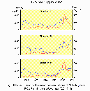
Trends of the mean concentrations of NH4-N (1) and PO4-P (2) in the surface layer (0.5 m)(8).
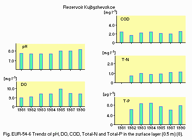
Trends of pH, DO, COD, Total-N and Total-P in the surface layer (0.5 m)(8).
F. BIOLOGICAL FEATURES
F1 FLORA (8)- Emerged macrophytes
Phragmites australis, Typha angustifolia, T. latifolia, Alisma plantago- aquatica, Carex acuta, Sagittaria sagittifolia, Eleocharis palustris, Equisetum fluviatile, Bolboschoenus maritimus, Cyperus fuscus, Epilobium palustre, Sparganium erectum. - Floating macrophytes
Spirodela polyrhiza, Lemna minor, L. trisulca, Salvinia natans, Hydrocharis morsus-ranae. - Submerged macrophytes
Potamogeton lucens, P. natans, P. pectinatus, P. perfoliatus, Najas marina, Caulinia minor, Utricularia intermedia, Elodea canadensis, Ceratophyllum demersum. - Phytoplankton
Melosira granulata, M. islandica, Cyclotella kuetzingiana, Stephanodiscus hantzschii, S. binderanus, Aphanizomenon flos-aquae, Microcystis aeruginosa, Chlamydomonas monadina, Ankistrodesmus scenedesmus.
- Zooplankton
Synchaeta pectinata, Asplanchna priodonta, Brachionus calyciflorus, Keratella quadrata, Daphnia longispina, Chydorus sphaericus, Bosmina longirostris, B. longispina, Leptodora kindtii, Cyclops kolensis, C. vicinus, Mesocyclops leuckarti, Acanthocyclops vernalis, Eudiaptomus gracilis, E. graciloides. - Benthos
Procladius jerrugineus, Chironomus plumosus, Isochaetides newaensis, I. michaelseni, Limnodrilus hoffmeisteri, Potamothrix hammoniensis, P. moldaviensis, Dikerogammarus haemobaphes, Pontogammarus obesus, Dreissena polymorpha, Amesoda solida, Viviparus viviparus, Hypania invalida. - Fish
Acipenser ruthenus*, Clupeonella delicatula caspia* (introduced), Osmerus eperlanus eperlanus (introduced), Esox lucius*, Rutilus rutilus*, Alburnus alburnus*, Blicca bjoerkna*, Abramis brama*, A. ballerus*, Pelecus cultratus*, Stizostedion lucioperca*, St. volgensis*, Perca fluviatilis, Gymnocephalus cernua, Leuciscus idus* (* economically important).
- Phytoplankton production
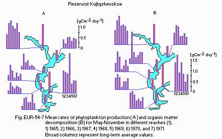
Mean rates of phytoplankton production (A) and organic matter decomposition
- for May November in different reaches (1). 1) 1965, 2) 1966, 3) 1967, 4) 1968, 5) 1969, 6) 1970, and 7) 1971 Broad columns represent long-term average values.
- Bacterial production
Bacteria production rates [g m-3 day 1] (1984) (8)
| S* | Jan | Feb | Mar | Apr | May | Jun | Jul | Aug | Sep | Oct | Nov | Dec |
|---|---|---|---|---|---|---|---|---|---|---|---|---|
| 8 | - | - | - | 1.36 | 0.54 | 0.24 | 0.64 | 0.28 | 0.13 | 0.53 | - | - |
| 21 | - | - | - | 0.51 | 0.66 | 0.59 | 0.46 | 0.20 | 0.03 | 0.41 | - | - |
| 34 | - | - | - | -0.01 | 0.36 | 0.39 | 0.25 | 0.12 | 0.12 | 0.21 | - | - |
- Bacterioplankton oxygen consumption rates [mg O2 l-1 day 1](8) (1984)
| S | Jan | Feb | Mar | Apr | May | Jun | Jul | Aug | Sep | Oct | Nov | Dec |
|---|---|---|---|---|---|---|---|---|---|---|---|---|
| 8 | - | - | - | - | 0.82 | 0.75 | 0.29 | 0.55 | - | - | - | - |
| 21 | - | - | - | - | 0.66 | 0.34 | 0.48 | 0.35 | 0.41 | 0.15 | - | - |
| 34 | - | - | - | - | - | 0.33 | 0.20 | 0.26 | 0.27 | - | - | - |
- Oxygen consumption rates in bottom sediments [mg O2 m-2 day 1](9) (1971)
| S | Jan | Feb | Mar | Apr | May | Jun | Jul | Aug | Sep | Oct | Nov | Dec |
|---|---|---|---|---|---|---|---|---|---|---|---|---|
| 21 | - | - | - | - | 210 | 430 | 210 | 80 | 170 | 230 | - | - |
| 34 | - | - | - | - | 160 | 550 | 140 | 140 | 210 | 200 | - | - |
- Infusoria production
Infusoria production rates [g m-3] (1989)(8)
| Jan | Feb | Mar | Apr | May | Jun | Jul | Aug | Sep | Oct | Nov | Dec | |
|---|---|---|---|---|---|---|---|---|---|---|---|---|
| Benthic Infusoria | - | - | - | - | - | 44.4 | 140.0 | - | 100.0 | 6.6 | - | - |
| Planktonic Infusoria | - | - | - | - | - | 42.1 | 118.0 | 69.8 | 31.4 | 10.4 | - | - |
- Supplementary notes
The organic matter decomposition at the surface of bottom sediment is estimated to be equivalent to 15 g C m-2 yr-1. It accounts for 24% of the average primary phytoplankton production and 9% of the total organic matter decomposition estimated for 1971 (9).
- Biomass of bacteria [g m-3](8)
| S* | Jan | Feb | Mar | Apr | May | Jun | Jul | Aug | Sep | Oct | Nov | Dec |
|---|---|---|---|---|---|---|---|---|---|---|---|---|
| 8 | - | - | - | - | 1.7 | 0.9 | 0.6 | 0.4 | 0.4 | 0.4 | - | - |
| 21 | - | - | - | - | 0.7 | 0.6 | 0.6 | 0.4 | 0.5 | 0.4 | - | - |
| 34 | - | - | - | - | 0.9 | 0.5 | 0.4 | 0.3 | 0.3 | 0.4 | - | - |
- Total bacterioplankton numbers [1.0E+6 ml 1]
| Station 34 , 1989 | ||||||||||||
| Depth [m] | Jan | Feb | Mar | Apr | May | Jun | Jul | Aug | Sep | Oct | Nov | Dec |
|---|---|---|---|---|---|---|---|---|---|---|---|---|
| 0 | - | - | - | - | 1.9 | 1.7 | 1.6 | 1.8 | 1.0 | 1.3 | 1.6 | - |
| 3-4 | - | - | - | - | 1.9 | 1.9 | 1.8 | 1.4 | 1.2 | 1.1 | 1.8 | - |
| 3-28 | - | - | - | - | 2.1 | 1.4 | 1.5 | 1.3 | 1.1 | 1.3 | 1.5 | - |
- Saprophytic bacteria numbers [103 ml 1]
| Station 34, 1989 | ||||||||||||
| Depth [m] | Jan | Feb | Mar | Apr | May | Jun | Jul | Aug | Sep | Oct | Nov | Dec |
|---|---|---|---|---|---|---|---|---|---|---|---|---|
| 0 | - | - | - | - | 1.5 | 0.7 | 0.2 | 3.4 | 0.7 | 0.3 | 0.3 | - |
| 3-4 | - | - | - | - | 0.5 | 0.3 | 0.2 | 2.0 | 0.3 | 0.4 | 0.1 | - |
| 3-28 | - | - | - | - | 1.0 | 0.4 | 0.3 | 0.8 | 0.3 | 0.7 | 0.1 | - |
- Biomass of phytoplankton [g m-3 (wet wt.)](8)
| Station 34, 1989 | ||||||||||||
| S*1 | Jan | Feb | Mar | Apr | May | Jun | Jul | Aug | Sep | Oct | Nov | Dec |
|---|---|---|---|---|---|---|---|---|---|---|---|---|
| B*2 | - | - | - | - | 2.36 | 2.12 | 0.08 | 1.15 | 2.85 | 4.45 | 2.90 | - |
| C*3 | - | - | - | - | 0.06 | 0.22 | 0.13 | 0.88 | 0.04 | 0.01 | 0.02 | - |
| C*4 | - | - | - | - | 0.00 | 0.42 | 1.39 | 3.80 | 0.79 | 0.22 | 0.01 | - |
| P*5 | - | - | - | - | 0.11 | 0.93 | 0.06 | 1.06 | 0.10 | 0.02 | 0.05 | - |
| Total | - | - | - | - | 2.53 | 3.69 | 1.66 | 6.89 | 3.78 | 4.70 | 2.98 | - |
| Station 34, 1990 | ||||||||||||
| S | Jan | Feb | Mar | Apr | May | Jun | Jul | Aug | Sep | Oct | Nov | Dec |
|---|---|---|---|---|---|---|---|---|---|---|---|---|
| B | - | - | - | - | 1.90 | 0.36 | 0.27 | 0.61 | 0.13 | 0.39 | 7.41 | - |
| C | - | - | - | - | 0.02 | 0.02 | 0.05 | 0.15 | 0.02 | 0.01 | 0.01 | - |
| C | - | - | - | - | 0.00 | 0.01 | 6.40 | 2.60 | 0.50 | 0.04 | 0.01 | - |
| P | - | - | - | - | 0.11 | 0.32 | 0.26 | 0.35 | 0.06 | 0.04 | 0.02 | - |
| Total | - | - | - | - | 2.03 | 0.71 | 6.98 | 3.71 | 0.71 | 0.48 | 7.44 | - |
| Station 39, 1989 | ||||||||||||
| S | Jan | Feb | Mar | Apr | May | Jun | Jul | Aug | Sep | Oct | Nov | Dec |
|---|---|---|---|---|---|---|---|---|---|---|---|---|
| B | - | - | - | - | 7.91 | 1.71 | 0.32 | 2.09 | 3.70 | 8.41 | 5.92 | - |
| C | - | - | - | - | 0.08 | 0.13 | 0.24 | 0.79 | 0.11 | 0.01 | 0.01 | - |
| C | - | - | - | - | 0.00 | 0.07 | 2.13 | 1.68 | 0.26 | 0.45 | 0.10 | - |
| P | - | - | - | - | 0.24 | 0.57 | 0.16 | 0.66 | 0.11 | 0.03 | 0.00 | - |
| Total | - | - | - | - | 8.23 | 2.48 | 2.85 | 5.22 | 4.18 | 8.90 | 6.03 | - |
| Station 39, 1990 | ||||||||||||
| S | Jan | Feb | Mar | Apr | May | Jun | Jul | Aug | Sep | Oct | Nov | Dec |
|---|---|---|---|---|---|---|---|---|---|---|---|---|
| B | - | - | - | - | 7.53 | 0.78 | 0.18 | 0.43 | 0.17 | 0.72 | 1.03 | - |
| C | - | - | - | - | 0.01 | 0.02 | 0.04 | 0.25 | 0.04 | 0.02 | 0.02 | - |
| C | - | - | - | - | 0.00 | 0.02 | 0.20 | 3.05 | 2.60 | 0.32 | 0.01 | - |
| P | - | - | - | - | 0.12 | 0.47 | 0.03 | 0.17 | 0.17 | 0.07 | 0.02 | - |
| Total | - | - | - | - | 7.66 | 1.29 | 0.45 | 3.90 | 2.98 | 1.13 | 1.08 | - |
- Biomass of benthos [g m-2 (wet wt.)](8)
| Station 34 | ||||||||||||
| Year | Jan | Feb | Mar | Apr | May | Jun | Jul | Aug | Sep | Oct | Nov | Dec |
|---|---|---|---|---|---|---|---|---|---|---|---|---|
| 1987 | - | - | - | - | - | 14.5 | 10.1 | 6.4 | 16.7 | 21.0 | 33.4 | - |
| 1988 | - | - | - | - | 36.4 | - | 6.8 | - | 35.9 | - | - | - |
| 1989 | - | - | - | - | 24.2 | 23.6 | 15.5 | 15.9 | 7.1 | 8.4 | 12.1 | - |
| Station 39 | ||||||||||||
| Year | Jan | Feb | Mar | Apr | May | Jun | Jul | Aug | Sep | Oct | Nov | Dec |
|---|---|---|---|---|---|---|---|---|---|---|---|---|
| 1988 | - | - | - | - | 6.41 | - | 2.16 | - | 3.38 | - | - | - |
| 1989 | - | - | - | - | 8.22 | 9.45 | 5.80 | 4.45 | 6.01 | 8.25 | 18.54 | - |
- Comparison of biomass of main taxa between the submerged bed of the R. Volga (station 34) and the flooded plain area (station 39)
| Group | Station 34 | Station 39 | |||
|---|---|---|---|---|---|
| 1987 | 1988 | 1989 | 1988 | 1989 | |
| Oligochaeta | 13.7 | 25.3 | 13.1 | 1.6 | 5.0 |
| Chironomidae | 1.0 | 0.9 | 1.1 | 1.0 | 0.7 |
| Polychaeta | 1.0 | - | 0.2 | 0.2 | 0.1 |
| Mollusca | 1.0 | 0.1 | 1.3 | 0.4 | 1.8 |
| Dreissena | - | - | 12.2 | 23.7 | 110.2 |
| Monodonta | 0.2 | - | - | 0.4 | - |
| Biomass of benthos in different reaches | ||||
| Reach | Station | 1983 | 1984 | 1985 |
|---|---|---|---|---|
| I | 9 | 0.7 | 2.6 | 0.9 |
| V | 21 | 48.6 | 41.3 | 37.1 |
| IX | 34 | 15.2 | 30.8 | - |
- Annual fish catch [metric tons](sport-fishing catch excluded)
1988: 5,928.
- Primary production and decomposition
Averages for the vegetation period and for the whole reservoir (8, 10, 11, 12)
| 1957 | 1958 | 1965 | 1966 | 1967 | 1968 | 1969 | 1970 | 1971 | |
|---|---|---|---|---|---|---|---|---|---|
| Phytoplankton production | 0.67 | 0.78 | 0.32 | 0.61 | 0.49 | 0.45 | 0.34 | 0.45 | 0.29 |
| Organic matter decomposition | 1.34 | 1.40 | - | 1.68 | 1.07 | 0.61 | 0.75 | 0.80 | 0.74 |
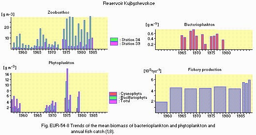
Trends of the mean biomass of bacterioplankton and phytoplankton and annual fish catch (1, 8).
- Trends of biomass [g m-3] of two phytoplankton groups* (averaged for the vegetation period and for the whole reservoir)(8)
| Year | Bacillariophyta | Cyanophyta | Total |
|---|---|---|---|
| 1975 | 5.67 | 5.12 | 11.91 |
| 1976 | 5.31 | 1.48 | 7.25 |
| 1978 | 7.49 | 1.30 | 9.25 |
| 1981 | 4.26 | 3.70 | 8.64 |
| 1982 | 3.01 | 1.95 | 5.57 |
| 1983 | 4.27 | 2.40 | 7.38 |
| 1984 | 4.57 | 3.81 | 8.74 |
G. SOCIO-ECONOMIC CONDITIONS
G1 LAND USE IN THE CATCHMENT AREA* (13) (1989)| Area [km2] | [%] | |
|---|---|---|
| Agricultural land | ||
| - Crop field | 475 | 33 |
| - Meadow | 355 | 24 |
| - Irrigated land | 61 | 4 |
| - Pasture | 560 | 39 |
| Total | 1,451 | 100 |
- Main species of forest and scrub vegetation
Salix alba, S. acutifolia, Populus nigra, P. alba, P. tremula, Ulmus laevis, Betula pendula, Viburnum opulus, Quercus robur, Abies sibirica, Picea abies, P. obovata, Pinus sylvestris, Acer tataricum (8). - Main species of herbaceous vegetation
Calamagrostis epigeios, Bromus squarrosus, Stipa pennata, Gypsophila paniculata, Helichrysum arenarium, Centaurea sumensis, Chondrilla juncea, Dianthus polymorphus, Artemisia absinthium, Salvia tesquicola, Veronica spicata, Astragalus cicer, Onobrychis arenaria, Hedysarum grandiflorum, Campanula sibirica, Scabiosa isetensis, Gurinea cyanoides, Aster amellus. - Main kinds of crops: Wheat, rye, sunflower, potato, maize.
- Main types of industries are building industry, chemical and oil processing industry, agricultural industry and municipal services.
| Population [x1.0E+3] | Population density[km-2] | Major cities | |
|---|---|---|---|
| Urban | 5,523 | - | Kazan, Ulianovsk, Naberezhnye Chelny, Tolyatty |
| Rural | 2,341 | - | |
| Total | 7,864 | 32.1 |
H. LAKE UTILIZATION
H1 LAKE UTILIZATION- Navigation and transportation, tourism and sightseeing, and recreation (swimming, sport-fishing, yachting).
| Use rate [1.0E+6 m3 yr-1] | |
|---|---|
| Domestic water | 975 |
| Industrial water | 1,753 |
| Irrigation | 915 |
| Agricultural water | 286 |
| Others | 401 |
| Total | 4,330 |
I. DETERIORATION OF LAKE ENVIRONMENTS AND HAZARDS
I1 ENHANCED SILTATION- Extent of damage: None.
- Supplementary notes
Mean sedimentation rate is 4 mm yr-1. About 60% of the reservoir bottom had been covered by silt in 1987 (14).
- Main contaminants and their concentrations
| Station 34, surface water, 1989 | |||
| Name of contaminant | Concentrations [micro l-1] | ||
|---|---|---|---|
| Sample no. | Mean | Range | |
| Cu | 6 | 3.4 | 2.4-3.8 |
| Pb | 5 | 0.5 | 0.4-1.2 |
| Ni | 6 | 4.8 | 1.3-13.8 |
| Cr | 6 | 0.05 | 0.01-0.1 |
| Zn | 6 | 10.8 | 2.4-23.1 |
| Cd | 6 | 0.01 | 0.01 |
| Station 34, bottom water, 1989 | |||
| Name of contaminant | Concentrations [micro l-1] | ||
|---|---|---|---|
| Sample no. | Mean | Range | |
| Cu | 6 | 4.0 | 2.2-5.5 |
| Pb | 6 | 0.3 | 0.1-0.3 |
| Ni | 6 | 4.9 | 1.9-9.0 |
| Cr | 6 | 0.02 | 0.01-0.1 |
| Zn | 6 | 12.8 | 4.1-29.0 |
| Cd | 5 | 0.01 | 0.01-0.1 |
| Reach IX, bottom mud, 1988 | ||||||
| Name of contaminant | Concentrations [micro g 1 (wet wt.)] | |||||
|---|---|---|---|---|---|---|
| 0.5N HCl extract | HNO3+H2O2 extract | |||||
| Sample no. | Mean | Range | Sample no. | Mean | Range | |
| Cu | 35 | 12 | 2-19 | 30 | 23 | 6-34 |
| Pb | 6 | 10 | 3-13 | 30 | 16 | 1-28 |
| Ni | 35 | 14 | 3-31 | 30 | 48 | 14-72 |
| Co | 35 | 8 | 2-12 | 30 | 13 | 5-20 |
| Cr | 35 | 8 | 2-14 | 30 | 24 | 1-50 |
| Zn | 35 | 29 | 5-61 | 30 | 65 | 19-175 |
- DDT concentrations in fish and molluscan tissues [mg kg 1](13) (1985-1986)
| Liver | Muscle | Brain | |
|---|---|---|---|
| Mollusca | |||
| - Viviparidae | - | 0.22 2.27*1 | - |
| Fish | |||
| - Stizostedion volgensis | 0.94(0.22-2.65)*2 | 0.21 (0.10-0.41) | 1.47 (0.58-4.06) |
| - Abramis ballerus | 0.68 (0.12-3.19) | 0.15 (0.11-0.18) | 6.40 (4.12-17.85) |
| - A. brama | 1.66 (0.19-6.63) | 0.27 (0.19-0.41) | 3.41 (2.28-5.17) |
*2 Mean value (range). Permissible level is 0.2 mg kg 1.
- Safety standards for contamination of foods or maximum permissible limits of
toxic substances (16)
| Name of contaminant | Maximum permissible limits [mg kg-1] | Notes |
|---|---|---|
| Cr | 0.2 | Natural wet wt. basis |
| Zn | 10.0 | |
| Ni | 0.5 | |
| Cu | 5.0 | |
| Pb | 0.5 | |
| Cd | 0.03 |
- Tends of change of contaminant concentration in water for the whole reservoir [mg l-1]
| Year | Phenol | Mineral oil | Surfactants | Zn | Fe | Cu | Cr6+ |
|---|---|---|---|---|---|---|---|
| 1986 | 0.006 | 0.08 | 0.04 | 0.004 | 0.06 | 0.012 | 0.002 |
| 1987 | 0.007 | 0.08 | 0.03 | 0.007 | 0.06 | 0.013 | 0.001 |
| 1988 | 0.005 | 0.08 | 0.02 | 0.008 | 0.07 | 0.013 | 0.001 |
| 1989 | 0.004 | 0.07 | 0.02 | 0.011 | 0.04 | 0.007 | 0.001 |
- Nuisance caused by eutrophication
Unusual algal bloom (Microcystis aeruginosa, Aphanizomenon flos-aquae). Disturbed filtration in cleaning beds for city water due to Melosira and Stephanodiscus bloom. - Nitrogen and phosphorus loadings to the reservoir [t y-1](18)
| Sources | Industrial*1 | Domestic*2 | Agricultural | Natural | Total |
|---|---|---|---|---|---|
| T-N | 528.1 | 797.3 | 3,568.5 | 2,886.4 | 7,780.3 |
| T-P | 55.1 | 103.1 | 157.2 | 77.9 | 393.3 |
*2 Municipal and settlement wastewater.
- Supplementary notes
N and P loadings from point sources were determined only for Reaches VIII and IX. Total N and P inputs to the whole water body were evaluated based on the records of inflow by rivers, precipitation and coast abrasion, and are equal to 61 g N m-2 yr-1 and 7 g P m-2 yr-1. The concentration of chlorophyll a of blue-green algae reaches 180 micro l-1 near point sources of pollutants (Q).
J. WASTEWATER TREATMENTS
J1 GENERATION OF POLLUTANTS IN THE CATCHMENT AREA- (d) Measurable pollution with wastewater treatment.
| For point sources only | |
| [%] | |
|---|---|
| Point sources | |
| - Municipal (after treatment) | 35.8 |
| - Industrial (with standard treatment) | 33.1 |
| - Conventionally treated water | 31.1 |
| Total | 100 |
- Primary treatment facilities: receiving box, gratings, quit chambers, primary settling basins.
Secondary treatment facilities: oxidation tanks.
Integrated treatment facilities: secondary settling basins, chlorine treatment.
M. LEGISLATIVE AND INSTITUTIONAL MEASURES FOR UPGRADING LAKE ENVIRONMENTS (Q)
M1 NATIONAL AND LOCAL LAWS CONCERNED- Names of the laws (the year of legislation)
- Basis of Water Laws of the USSR and Republics (1970)
- On the Protection of Nature in Russia Federation (1960)
- The Resolution of the USSR Council of Ministers "On Measures Preventing the Sewage Flow into the Basins of Rivers Volga and Ural" (1972)
- The Resolution of the USSR Council of Ministers "On Improvement of Ecological Conditions in Tolyatty " (1988)
- The Resolution of the Kujbyshev Municipality "On Municipality's Tasks on Environmental Protection and Use of the Natural Resources" (1987)
- USSR State Hydrometeorologic Service
- Committee on the River Volga Saving (formed 1989 in Moscow)
- Volga Basin and Northern Part of the Caspian Sea Ecologic Parliament (formed 1990 in Moscow)
- Volga Basin Ecology Institute of the USSR Academy of Sciences, Tolyatty
- Kazan Biology Institute, Kazan Scientific Centre of the USSR Academy of Sciences, Kazan
- Tatar Department of the Lake and River Fishery State Scientific Institute, Kazan
- Tolyatty Hydrometeorological Observatory, Goskomgydromet of USSR, Tolyatty
- Kazan State University, Kazan
- Ulianovsk Pedagogical Institute, Ulianovsk
- Volga-Kama State Reserve, Zelenodolsk
- Samara Medical Institute, Samara
- Zhiguly Reserve, Zhiguliovsk
N. SOURCES OF DATA
- Questionnaire filled by Dr. L. A. Vyhrystiuk, Volga Basin Ecology Institute of USSR Academy of Sciences, Tolyatty, USSR.
- The Reservoir Kujbyshevskoe (1983) Publishing House "Nauka", St. Petersburg. 214 pp.*
- Obedientova, G. V. (1977) The Cycles of Erosion and Formation of the Volga Valley. Moscow. 240 pp.*
- Chigirinskaya, K. P. (1963) Characteristics of the storm conditions formed in the Reservoir Kujbyshevskoe. Proc. of the First Scientific -Technical Conf. on Research of the Reservoir Kujbyshevskoe, Issue 2: 135 144. Kujbyshev.*
- Hydrometeorological Regime of the USSR Lakes and Reservoirs: Kujbyshevskoe and Saratovskoe (1978). Publishing House "Hydrometeoizdat", St. Petersburg. 269 pp.*
- Borovkova, T. N., Nikulin, P. I. & Shirokov, V. M. (1962) The Reservoir Kujbyshevskoe (Short Physiographic Characteristics), p. 92. Kujbyshev.*
- Chigirinsky, P. J. (1971) Investigation of the Hydrometeorological conditions of waves and currents formed in the Reservoir Kujbyshevskoe. Collected Articles by the Tolliatinskaya Observatory, Issue 9: 121 155. Publishing House "Hydrometeoizdat", St. Petersburg.*
- Tolliatinskaya Hydrometeorological Observatory data.
- Volga Basin Ecology Institute of USSR Academy of Sciences data.
- Evatin, A. V. (1973) The oxygen utilization and organic matter destruction in the bottom sediments of the Reservoir Kujbyshevskoe. Hydrobiologicheskij Journal, 9 (5): 40 438.*
- Salmanov, M. A. & Sorokin, Ju. I. (1962) Primary production in the Reservoir Kujbyshevskoe. Proc. USSR Acad. Sci., 4: 603 613.*
- Pyrina, I. L. (1966) Primary phytoplankton production in the Reservoirs Ivankovshoe, Rybinskoe and Kujbyshevskoe in dependence on some factors. Production and the Cycle of the Organic Matter in the Interior Reservoirs, pp. 249 270. Publishing House "Nauka", Moscow -St. Petersburg.*
- Evatin, A. V. (1974) Phytoplankton production and organic matter destruction in the Reservoir Kujbyshevskoe. Hydrobiologicheskij Journal, 10 (3): 65 69.*
- Studying the Main Components of the Water Ecosystem in the Central Part of the Reservoir Kujbyshevskoe (1989). Proc. of the Kazan Univ. 146 pp.*
- Vyhrystiuk, L. A. (1991) The current state of the bottom deposits. Landscape Dynamic in the Reservoir Kujbyshevskoe Zone, p. 22. Publishing House "Nauka", St. Petersburg.
- Data on the biology by the Inland Water Institute of the USSR Academy of Sciences, Borok.
- The sanitary norms and rules 42 123 40898 (1986). USSR Minzdrav.
- The Ecology of Phytoplankton in the Reservoir Kujbyshevskoe (1989). Publishing House "Nauka", St. Petersburg.
- Vyhrystiuk, L. A. (1989) The influence of the technogenical loading upon water quality of the Reservoir Kujbyshevskoe. Ecological Problems of the River Volga, Part I, pp. 46 48. Saratov.
* Printed in Russian.
