LAKE CHERVONOJE
A view on the lakeshore
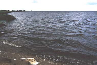
Photo: Res.Lab.Limnol., Belarus State Univ.
A. LOCATION
- Belarus.
- 52:24N, 27:58E; 136 m above sea level.
B. DESCRIPTION
Lake Chervonoje is one of the largest lakes in Belarus Republic. It is located in the watershed of the River Pripiat, a right-side tributary of the River Dnepr that drains into the Black Sea. The lake water originates partly from the seepage of groundwater in the enormous marshy lowland of Polesie.
Surface runoff from the catchment area is partially regulated by diking marsh systems and peat bogs for drainage or moisture supply. Though the shoreline is embanked, natural shores are low being sandy and peaty on the southern side of the lake. The lake water level has now been lowered by 0.4 m in comparison with the former natural level, and fluctuates with an annual range of 0.3 0.4 m. Deeper lake bottom is covered by siliceous ooze rich in decaying organic matter. An intensive sediment re-suspension due to wind force takes place in the ice-free period. Transparency of the lake water becomes as small as 0.1 m in summer. Dissolved oxygen in the lake water is exhausted at the end of the freezing period. Total mineral contents amount to 200 240 mg l-1, and the level of organic matter content is also high.
Eighteen species of macrophytes have been recorded in the lake, and 24% of its surface area are covered by their growth. There are 288 taxa of phytoplankton, their maximum biomass reaching 80 g m-3. The species number and summer biomass of zooplankton amounts to 197 and 0.8 g m-3, while those of zoobenthos to 107 and 22 g m-2, respectively.
L. Chervonoje is intensively used. The lake water is pumped up freely throughout the year for fish farming. Drainage water from diked marshes and peat plots for agricultural uses is discharged directly into the lake from pumping stations. The extraction of lake sediments for industrial uses is estimated at 100,000 t yr-1. Fish fingerlings, particularly of Carassius auratus, are released into the lake every year, and the annual fish production amounts to 15 kg ha-1. There are villages such as Puchovichi, Liachovichi, etc. along the lakeshore (1).
C. PHYSICAL DIMENSIONS (2)
| Surface area [km2] | 40 |
| Volume [km3] | 0.046 |
| Maximum depth [m] | 4.5 |
| Mean depth [m] | 1.2 |
| Water level | Regulated |
| Normal range of annual water level fluctuation [m] | 0.4 |
| Length of shoreline [km] | 30.8 |
| Residence time [yr] | 0.6 |
| Catchment area [km2] | 353 |
D. PHYSIOGRAPHIC FEATURES
D1 GEOGRAPHICAL (1)
- Bathymetric map: Fig. EUR-50-1.
- Number of main islands (name): 5 (nameless).
- Number of outflowing rivers and channels (name)
2 (Zhitkovichskij and Oziornij).
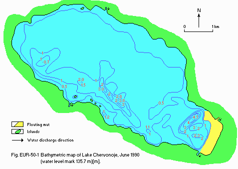
Fig. EUR-50-1
Bathymetric map, June 1990 (water level mark 135.7 m)[m].
D2 CLIMATIC
- Climatic data at Chikovichi, 1945 1989 (3)
| Jan | Feb | Mar | Apr | May | Jun | Jul | Aug | Sep | Oct | Nov | Dec | Ann. |
| Mean temp. [deg C] | -6.1 | -5.1 | -0.5 | 7.4 | 13.3 | 17.1 | 18.6 | 16.9 | 12.5 | 6.7 | 1.4 | -2.7 | 6.6 |
| Precipitation [mm] | 43 | 34 | 34 | 40 | 59 | 84 | 81 | 78 | 53 | 48 | 53 | 49 | 656 |
- Water temperature [deg C]
| Station 1, 1985-1989 |
| Depth [m] | Jan | Feb | Mar | Apr | May | Jun | Jul | Aug | Sep | Oct | Nov | Dec |
| 0 | - | - | - | 7.8 | 15.9 | 19.1 | 21.1 | 19.6 | 13.9 | 7.0 | - | - |
- Freezing period: From December to April.
- Mixing type: Polymictic.
E. LAKE WATER QUALITY (3)
E1 TRANSPARENCY
| Station 1, 1990 |
| Jan | Feb | Mar | Apr | May | Jun | Jul | Aug | Sep | Oct | Nov | Dec |
| - | - | - | 1.3 | - | 0.2 | 0.4 | - | - | - | - | - |
E2 pH
| Station , 1985-1989 |
| Depth [m] | Jan | Feb | Mar | Apr | May | Jun | Jul | Aug | Sep | Oct | Nov | Dec |
| 1 | - | - | 7.3 | 7.4 | 7.8 | - | - | - | 7.7 | - | 7.1 | - |
E3 SS [mg l-1]
| Station 1, 1985-1989 |
| Depth [m] | Jan | Feb | Mar | Apr | May | Jun | Jul | Aug | Sep | Oct | Nov | Dec |
| 0 | - | - | 14.4 | 12.5 | 10.7 | - | - | - | 39.8 | - | 20.0 | - |
E4 DO [mg l-1]
| Station 1, 1985-1989 |
| Depth [m] | Jan | Feb | Mar | Apr | May | Jun | Jul | Aug | Sep | Oct | Nov | Dec |
| 1 | - | - | 5.3 | 10.3 | 9.7 | - | - | - | 7.3 | - | 9.4 | - |
E5 COD [mg l-1]
Determined by K2Cr2O7 method.
| pcStation 1, 1985-1989 |
| Depth [m] | Jan | Feb | Mar | Apr | May | Jun | Jul | Aug | Sep | Oct | Nov | Dec |
| 1 | - | - | 33.7 | 37.9 | 36.6 | - | - | - | 33.5 | - | 26.7 | - |
E7 NITROGEN CONCENTRATION
- Total mineral-N [(NH4+NO2+NO3) N][mg l-1]
| Station 1, Average of 1986, 1987 and 1989 |
| Depth [m] | Jan | Feb | Mar | Apr | May | Jun | Jul | Aug | Sep | Oct | Nov | Dec |
| 1 | - | - | 0.53 | 0.40 | 1.11 | - | - | - | 1.00 | - | 0.41 | - |
E8 PHOSPHORUS CONCENTRATION
| Station 1, 1986-1989 |
| Depth [m] | Jan | Feb | Mar | Apr | May | Jun | Jul | Aug | Sep | Oct | Nov | Dec |
| 1 | - | - | 2.067 | 0.467 | 0.796 | - | - | - | 0.216 | - | 1.288 | - |
E10 PAST TRENDS
| Depth [m] | 1965 | 1966 | 1967 | 1968 | 1969 | 1970 | 1971 | 1972 | 1973 | 1974 | 1975 |
| 1 | 7.0 | 7.0 | 7.3 | 7.5 | 7.5 | 7.6 | 7.2 | - | 7.4 | 7.4 | 7.7 |
| Depth [m] | 1976 | 1977 | 1978 | 1979 | 1980 | 1981 | 1982 | 1983 | 1984 | 1985 | 1986 |
| 1 | 7.7 | 7.7 | 7.4 | 7.0 | 7.6 | 7.5 | 7.4 | 7.9 | 7.4 | 7.4 | 7.4 |
| Depth [m] | 1987 | 1988 | 1989 | 1990 |
| 1 | 7.4 | 7.7 | 7.7 | 7.7 |
| Depth [m] | 1976 | 1977 | 1978 | 1979 | 1980 | 1981 | 1982 | 1983 | 1984 | 1985 | 1986 |
| 1 | 8.9 | 14.9 | 21.3 | 20.3 | 12.1 | 9.3 | 11.4 | 17.8 | 14.6 | 15.2 | 23.1 |
| Depth [m] | 1987 | 1988 | 1989 |
| 1 | 16.8 | 13.2 | 20.8 |
| Depth [m] | 1973 | 1974 | 1975 | 1976 | 1977 | 1978 | 1979 | 1980 | 1981 | 1982 | 1983 |
| 1 | 7.8 | 9.5 | 9.6 | 9.0 | 9.6 | 9.8 | 8.7 | 8.9 | 8.5 | 8.3 | 12.3 |
| Depth [m] | 1984 | 1985 | 1986 | 1987 | 1988 | 1989 |
| 1 | 12.1 | 9.0 | 8.8 | 6.9 | 7.5 | 8.8 |
- COD [mg l-1]
Determined by K2Cr2O7 method.
| Depth [m] | 1965 | 1966 | 1967 | 1968 | 1969 | 1970 | 1971 | 1972 | 1973 | 1974 | 1975 |
| 1 | 100.8 | 123.4 | 99.8 | 73.8 | 76.5 | 63.4 | 88.1 | - | 86.9 | 61.2 | 68.0 |
| Depth [m] | 1976 | 1977 | 1978 | 1979 | 1980 | 1981 | 1982 | 1983 | 1984 | 1985 | 1986 |
| 1 | 77.7 | 43.7 | - | 26.9 | 42.2 | 42.1 | 47.8 | 49.6 | 43.8 | 38.6 | 31.8 |
| Depth [m] | 1987 | 1988 | 1989 |
| 1 | 42.6 | 27.7 | 31.7 |
- Total mineral-N [(NH4+NO2+NO3)-N][mg l-1]
| Depth [m] | 1965 | 1966 | 1967 | 1968 | 1969 | 1970 | 1971 | 1972 | 1973 | 1974 | 1975 |
| 1 | 0.46 | 1.74 | 1.39 | 1.25 | 0.93 | 1.30 | 0.85 | - | 0.68 | 0.93 | 2.06 |
| Depth [m] | 1976 | 1977 | 1978 | 1979 | 1980 | 1981 | 1982 | 1983 | 1984 | 1985 | 1986 |
| 1 | 0.18 | 0.97 | 0.69 | 0.82 | 0.75 | 0.55 | 0.31 | 0.19 | - | - | 0.81 |
| Depth [m] | 1987 | 1988 | 1989 |
| 1 | 0.98 | 0.14 | 0.57 |
| Depth [m] | 965 | 1966 | 1967 | 1968 | 1969 | 1970 | 1971 | 1972 | 1973 | 1974 | 1975 |
| 1 | 0.036 | 0.047 | 0.065 | 0.023 | 0.038 | 0.047 | 0.036 | - | 0.050 | 0.014 | 0.024 |
| Depth [m] | 1976 | 1977 | 1978 | 1979 | 1980 | 1981 | 1982 | 1983 | 1984 | 1985 | 1986 |
| 1 | 0.065 | 0.041 | 0.034 | 0.025 | 0.062 | 0.035 | - | - | - | 0.040 | - |
| Depth [m] | 1987 | 1988 | 1989 |
| 1 | 0.078 | 0.086 | 0.091 |
F. BIOLOGICAL FEATURES (1, 2)
F1 FLORA
- Emerged macrophytes
Phragmites australis, Scirpus lacustris, Typha angustifolia, T. latifolia, Sparganium emersum, Eleocharis acicularis.
- Floating macrophytes
Nuphar lutea, Spirodela polyrhiza, Hydrocharis morsus-ranae, Lemna trisulca, L. minor.
- Submerged macrophytes
Stratiotes aloides , Potamogeton perfoliatus, P. natans, P. crispus, P. friesii, Elodea canadensis, Ceratophyllum sp.
- Phytoplankton
Microcystis pulverea f. pulverea, Lyngbya limnetica f. limnetica, Aphanizomenon flos-aquae f. flos-aquae, Aphanothece clathrata f. clathrata, Melosira italica var. italica, Diatoma elongatum f. actinastroides, Asterionella formosa, Fragilaria crotonensis.
F2 FAUNA
- Zooplankton
Rotatoria (Asplanchna priodonta, Keratella cochlearis, K. quadrata, Polyarthra sp.); Copepoda (Mesocyclops leuckarti); Cladocera (Bosmina longirostris, Daphnia cucullata, Diaphanosoma brachyurum).
- Benthos
Chironomus plumosus, Procladius, Glyptotendipes, Einfeldia carbonaria, Tanytarsus lauterborni, Polypedilum scalaenum, Pisidium.
- Fish
Carassius auratus*, Esox lucius, Abramis brama (* economically important).
F3 PRIMARY PRODUCTION RATE [mg C l-1 day 1]
Net primary production: 0.97
Respiration: 0.44
Gross primary production: 1.41
F4 BIOMASS
- Phytoplankton, zooplankton [g m-3] and zoobenthos [g m-2] (1990)
| Plankton | Jan | Feb | Mar | Apr | May | Jun | Jul | Aug | Sep | Oct | Nov | Dec |
| P*1 | - | - | - | 11.77 | - | 66.57 | 80.62 | - | - | - | - | - |
| Z*2 | - | - | - | 1.16 | - | 0.77 | 0.83 | - | - | - | - | - |
| Z*3 | - | - | - | 11.42 | - | 7.18 | 21.49 | - | - | - | - | - |
*1 Phytoplankton. *2 Zooplankton. *3 Zoobenthos.
F5 FISHERY PRODUCTS
- Annual fish catch [metric tons]
1989: 62.
F6 PAST TRENDS
- Annual fish catch [t] and fishery production [kg ha-1 yr-1]
| 1981 | 1982 | 1983 | 1984 | 1985 | 1986 | 1987 | 1988 | 1989 |
| Fish catch | 73 | 164 | 187 | 100 | 150 | 93 | 146 | 157 | 62 |
| Fishery production | 18.3 | 41.4 | 48.2 | 29.6 | 39.2 | 24.0 | 37.9 | 40.1 | 15.7 |
- Phytoplankton biomass [g m-3]
| Year | Jan | Feb | Mar | Apr | May | Jun | Jul | Aug | Sep | Oct | Nov | Dec |
| 1949 | - | - | - | - | - | - | - | 600.0 | - | - | - | - |
| 1962 | - | - | - | - | 225.5 | 43.4 | - | - | - | - | - | - |
| 1966 | - | - | - | - | - | 159.1 | - | - | - | - | - | - |
| 1968 | - | - | 2.7 | - | - | 103.5 | - | 63.4 | - | - | - | - |
| 1974 | - | - | 0.7 | - | - | - | - | - | - | - | - | - |
| 1978 | - | 0.1 | 0.1 | 13.3 | 11.4 | 28.4 | 23.5 | 232.5 | - | 19.1 | - | - |
| 1985 | - | - | - | - | - | - | 26.7 | - | - | - | - | - |
| 1990 | - | - | - | 11.7 | - | 66.6 | 80.6 | - | - | - | - | - |
- Zooplankton biomass [g m-2]
| Year | Jan | Feb | Mar | Apr | May | Jun | Jul | Aug | Sep | Oct | Nov | Dec |
| 1962 | - | - | 3.14 | - | 4.23 | - | 4.33 | 3.27 | 2.25 | - | - | - |
| 1974 | - | - | 0.03 | - | - | - | - | - | - | - | - | - |
| 1978 | - | 0.7 | 0.5 | 0.6 | 2.9 | 12.8 | 2.2 | 1.8 | - | 2.2 | 3.2 | - |
| 1979 | 0.4 | 0.5 | - | - | - | - | - | - | - | - | - | - |
| 1985 | - | - | - | - | - | - | 0.16 | - | - | - | - | - |
| 1990 | - | - | - | 1.16 | - | 0.77 | 0.83 | - | - | - | - | - |
- Zoobenthos biomass [g m-2]
| Year | Jan | Feb | Mar | Apr | May | Jun | Jul | Aug | Sep | Oct | Nov | Dec |
| 1949 | - | - | - | - | - | - | - | 33.51 | - | - | - | - |
| 1954 | - | - | 19.86 | - | - | - | - | 11.77 | - | - | - | - |
| 1962 | - | - | 0.55 | - | 0.63 | - | 0.37 | 6.05 | 32.60 | - | - | - |
| 1966 | - | - | - | - | - | - | 0.0 | - | 0.0 | - | - | - |
| 1968 | - | - | 0.0 | - | - | 0.57 | - | 1.67 | - | - | - | - |
| 1974 | - | - | 2.81 | - | - | - | - | - | - | - | - | - |
| 1978 | - | 9.4 | 8.0 | 11.8 | 10.9 | 10.0 | 8.27 | 3.8 | - | 13.3 | 8.1 | - |
| 1979 | 16.8 | 19.0 | - | - | - | 4.5 | - | 15.0 | - | - | - | - |
| 1985 | - | - | - | - | - | - | 9.34 | - | - | - | - | - |
| 1990 | - | - | - | 11.42 | - | 7.18 | 21.49 | - | - | - | - | - |
G. SOCIO-ECONOMIC CONDITIONS (2)
G1 LAND USE IN THE CATCHMENT AREA (1990)
| Area [km 2] | [%] |
| Natural landscape |
| - Woody vegetation | 167.9 | 47.6 |
| - Grassland vegetation | 44.4 | 12.6 |
| - Swamp | 7.5 | 2.1 |
| - Others | 78.6 | 22.3 |
| Agricultural land 31.4 8.9 |
| - Crop field | 20.1 | 5.7 |
| - Pasture | 11.3 | 3.2 |
| Residential area |
| Others | 22.9 | 6.5 |
| Total | 352.7 | 100.0 |
- Main species of forest and scrub vegetation
Alnus incana, A. glutinosa, Pinus sylvestris, Quercus robur, Salix alba.
- Main species of herbaceous vegetation
Carex pilosa, C. acuta, C. leporica, C. digitata, Festuca pratensis, Poa pratensis.
- Main kinds of crops: Rye, wheat, barley, oat, sugar beet, potato.
- Levels of fertilizer application on crop fields: Heavy.
H. LAKE UTILIZATION
H1 LAKE UTILIZATION
Source of water, fisheries, extraction of bottom sediments (ooze), and water reservoir for diked marsh systems.
H2 THE LAKE AS WATER RESOURCE (3) (1987)
| Use rate [m3 day 1] |
| Water supply for fish farms | 25 |
I. DETERIORATION OF LAKE ENVIRONMENTS AND HAZARDS
I1 ENHANCED SILTATION
- Extent of damage: Serious.
I2 TOXIC CONTAMINATION
- Present status: Serious.
- Main contaminants, their concentrations and sources (2) (1989)
| Name of contaminant | Range of concentrations | Main sources in water [mg l-1] |
| Oil products | 0.06-0.20 |
| Cu | 0.003-0.012 | Agricultural activity |
| Ni | 0.003-0.004 |
| Phenols | 0.0-0.008 |
- Ecologically permissible levels of pollutants in the water environment [mg
l 1] Oil products 0.05, Cu 0.01, Ni, Zn 0.01, Pb 0.1, phenols 0.001, hexachloran, DDT 0.
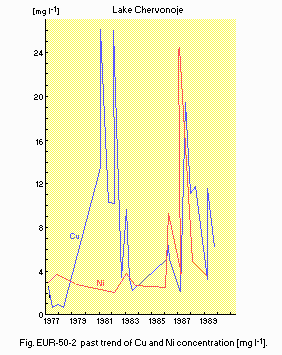
Fig. EUR-50-2
Past trend of Cu and Ni concentration [mg l-1](2).
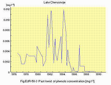
Fig. EUR-50-3
Past trend of phenols concentration [mg l-1](2).
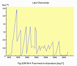
Fig. EUR-50-4
Past trend of oil products [mg l-1](2).
I3 EUTROPHICATION
- Nuisance caused by eutrophication
Unusual algal bloom (Microcystis pulverea, Lyngbya limnetica, Aphanizomenon flos-aquae, Aphanothece clathrata).
- Phosphorus loading to the lake, 1990: 19 40 [kg day 1].
I4 ACIDIFICATION
J. WASTEWATER TREATMENTS
J1 GENERATION OF POLLUTANTS IN THE CATCHMENT AREA
(f) Severe pollution with poor control of agricultural wastewater.
J2 APPROXIMATE PERCENTAGE DISTRIBUTION OF POLLUTANT LOADS (4) (1989)
| [%] |
| Non-point sources |
| - Agricultural | 13 |
| - Natural | 9 |
| Point sources |
| - Peat mining | 55 |
| - Extraction of bottom ooze | 23 |
| Total | 100 |
L. DEVELOPMENT PLANS (2)
Rates of the construction of diked marsh systems in the catchment area: 34 km2 in 1983, 29 km2 in 1987 and 6 km2 in 1989.
M. LEGISLATIVE AND INSTITUTIONAL MEASURES FOR UPGRADING LAKE ENVIRONMENTS
M1 NATIONAL AND LOCAL LAWS CONCERNED
- Names of the laws (the year of legislation)
- On Measures of Prevention of the Rivers and Other Water Bodies Pollution within the Black Sea Basin (1979)
- On Measures for Protection and Rational Using of the Water Bodies in Republic (1989)
- On Ratification of the Principle Concerning the Water Protection Zones for Belarussia Water Bodies (1989)
- Responsible authorities
- Republic Belarus State Committee for Ecology
M2 INSTITUTIONAL MEASURES
- Ecological Union of Belarus
M3 RESEARCH INSTITUTES ENGAGED IN THE LAKE ENVIRONMENT STUDIES
- Branch Scientific-Research Laboratory of Limnology, Belarus State University, Minsk
- Belarus Board of Hydrometeorology and Environmental Control
- Belarus Scientific-Research and Design Institute of Fisheries
- Institute of Problems for Natural Resources Usage and Ecology of Republic Belarus Academy of Sciences
N. SOURCES OF DATA
- Questionnaire filled by Drs. O. F. Iakushko, V. P. Romanov, L. V. Gurianova, S. F. Tumishskaya, A. H. Rachevskij, C. A. Bojkova, V. P. Vlasov, G. S .Gigevich, Z. K. Kartashevich and V. M. Samoilenko, Branch of Scientific-Research Laboratory of Limnology, Belarus State University, Minsk. The following references are all printed in Russian.
- Iakushko, O. F. (1981) Limnology, The Geography of Belarus Lakes. 223 pp. Minsk.
- Branch Scientific-Research Laboratory of Limnology (1990) Report on Measures for Restoration of the Lake Chervonoje Ecosystem (Zhitkovichskij District, Belarus). Minsk.
- Belarus Board of Hydrometeorology and Control of Environment (1991) Statistical Data for 1925 1989. Minsk.

