
LAKE BALTA ALBA
A view on the lakeshore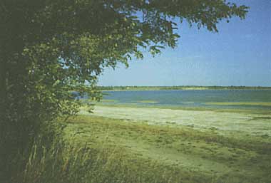
Photo: V.A.C.Bulgareanu
A. LOCATION
- Buzau and Braila Districts, Romania.
- 45:17N, 27:20E; 22.66* m above sea level.
* 1983.
B. DESCRIPTION
-
The Lake Balta Alba is located in the Ramnic Plain just south of the highway between the cities of Ramnicu-Sarat and Braila. The southern lake shore - loessial bluff up to 24 m in height - contrasts sharply with the almost flat surrounding landscape. Seen from the bluff top, the lake displays a rich- coloured palette: the yellow of loessial bluff, the white of saline efflorescences on the beach, different shades of green belonging to reed, algae and aquatic weeds dominating, the lake water mass in summer, ...
From the limnogenetic standpoint, the lake is a fluviatile "liman" formed by the alluvial damming up of an old Ramnic river bed at its confluence with the Buzau River, as a consequence of Holocene neotectonic subsidence. After the freshwater accumulation, the setting and abrasion of loess-like deposits (Upper Pleistocene - Lower Holocene) modelled the existing lake basin. The present lake, brackish, shallow, dimictic, eutrophic, and pelogenous (= with unctuous, rich-organic, therapeutical muds) is strongly influenced by freshwater inputs from precipitation and Boldu Brook, in connection with the fluctuations of steppe climate. It has only one tributary, Boldu Brook, and no outlet stream.
The sapropelic mud therapy dates back to as early as 1840, the year of the beginning of such treatments in Romania. Recent multi-disciplinary researches characterized the lake as one of the important Romanian sources of therapeutical sapropelic mud, which is recommended for the treatment of some rheumatic, articular and dermatological diseases. The therapy uses the mud itself (either by outdoor application in the camping "la Plaja" or by indoor treatments in Balta Alba Spa located ca. 2 km west of the lake) or the "Pell- Amar" extract (= saline interstitial) solution obtained by squeezing the mud (Q, 2, 3, 16).
C. PHYSICAL DIMENSIONS
| Surface area [km2] | 11 |
| Volume [km3] | 0.0118 |
| Maximum depth [m] | 2 |
| Mean depth [m] | 1.1 |
| Water level | Unregulated |
| Normal range of annual water level fluctuation [m] | 0.4-0.7 |
| Length of shoreline [km] | 17.5 |
| Residence time [yr] | 1.1* |
| Catchment area [km2] | 91.6 |
D. PHYSIOGRAPHIC FEATURES (Q, 3, 5, 7, 11)
D1 GEOGRAPHICAL- Bathymetric map: Fig. EUR-41-01.
- Names of main islands: None.
- Number of outflowing rivers and channels (name): None.
- Climatic data at Faurei, Braila district, 1896-1965
| Jan | Feb | Mar | Apr | May | Jun | Jul | Aug | Sep | Oct | Nov | Dec | Ann. | |
|---|---|---|---|---|---|---|---|---|---|---|---|---|---|
| Mean temp. [deg C] | -3.0 | -1.1 | 3.9 | 10.5 | 16.2 | 20.1 | 22.5 | 21.7 | 17.0 | 10.9 | 4.8 | -0.3 | 10.8 |
| Precipitation [mm] | 25 | 22 | 29 | 35 | 45 | 62 | 49 | 40 | 36 | 31 | 25 | 30 | 429 |
- Number of hours of bright sunshine: ca. 2,100 hr yr-1.
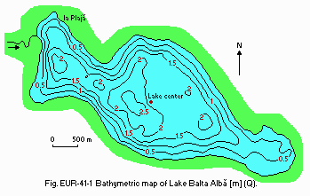
Bathymetric map [m](Q).
- Water temperature [deg C]
| Lake centre | ||||||||||||
| Depth [m] | Jan | Feb | Mar | Apr | May | Jun | Jul | Aug | Sep | Oct | Nov | Dec |
|---|---|---|---|---|---|---|---|---|---|---|---|---|
| S* | - | - | - | - | 20.8 | 24.0 | 27.0 | 26.0 | 19.6 | 13.0 | 6.0 | - |
- Freezing period: December-February (60-75 days).
- Mixing type: Dimictic.
E. LAKE WATER QUALITY (Q, 2, 3, 5, 10)
El TRANSPARENCY [m]| Lake centre, 1983-1987 | |||||||||||
| Jan | Feb | Mar | Apr | May | Jun | Jul | Aug | Sep | Oct | Nov | Dec |
|---|---|---|---|---|---|---|---|---|---|---|---|
| - | - | - | - | 0.25 | - | 0.30 | 0.29 | 0.32 | 0.33 | 0.30 | - |
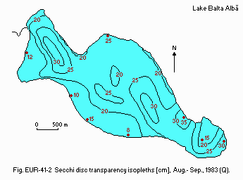
Secchi disc transparency isopleths [cm], August-September 1983 (Q).
E2 pH
| Lake centre, 1983-1987 | ||||||||||||
| Depth [m] | Jan | Feb | Mar | Apr | May | Jun | Jul | Aug | Sep | Oct | Nov | Dec |
|---|---|---|---|---|---|---|---|---|---|---|---|---|
| S* | - | - | - | - | 8.65 | 8.60 | 8.00 | 8.36 | 8.73 | 8.27 | 8.30 | - |
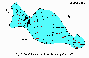
Lake water pH isopleths, August-September 1983.
E3 SS [mg l-1]
| Lake centre, 1983-1987 | ||||||||||||
| Depth [m] | Jan | Feb | Mar | Apr | May | Jun | Jul | Aug | Sep | Oct | Nov | Dec |
|---|---|---|---|---|---|---|---|---|---|---|---|---|
| S* | - | - | - | - | 35.8 | - | 47.1 | - | 28.9 | 29.9 | - | - |
- Determined by KMnO4 method.
| Lake centre, 1983-1987 | ||||||||||||
| Depth [m] | Jan | Feb | Mar | Apr | May | Jun | Jul | Aug | Sep | Oct | Nov | Dec |
|---|---|---|---|---|---|---|---|---|---|---|---|---|
| S* | - | - | - | - | 19.2 | - | 21.3 | - | 21.2 | 16.8 | - | - |
- Total-N [mg l-1]*1
| Lake centre, 1983-1987 | ||||||||||||
| Depth [m] | Jan | Feb | Mar | Apr | May | Jun | Jul | Aug | Sep | Oct | Nov | Dec |
|---|---|---|---|---|---|---|---|---|---|---|---|---|
| S* | - | - | - | - | 0 | - | 0.03 | - | 0.42 | 0.39 | - | - |
- PO4-P [mg l-1]
| Lake centre, 1983-1987 | ||||||||||||
| Depth [m] | Jan | Feb | Mar | Apr | May | Jun | Jul | Aug | Sep | Oct | Nov | Dec |
|---|---|---|---|---|---|---|---|---|---|---|---|---|
| S* | - | - | - | - | 0.03 | - | 0.10 | - | 0.06 | 0.01 | - | - |
| Lake centre, surface, 1983-1987 | ||||||||
| Na | K | Mg | Ca | Cl | SO4 | HCO3 | Total dissolved solids | |
|---|---|---|---|---|---|---|---|---|
| May | 2,825 | 32.8 | 204 | 22.8 | 3,582 | 1,238 | 946 | 8,240 |
| Jul | 2,710 | 27.8 | 177 | 38.5 | 3,452 | 1,038 | 956 | 7,970 |
| Sep | 3.578 | 35.5 | 198 | 44.3 | 6,625 | 1,546 | 1,140 | 8,840 |
| Oct | 3,110 | 32.3 | 196 | 64.1 | 3,735 | 1,273 | 695 | 9,120 |
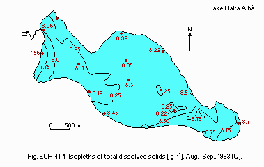
Isopleths of total dissolved solids [g l-1], August-September 1983 (Q).
E10 PAST TRENDS
- Total dissolved solids concentration: Fig. EUR-41-05.
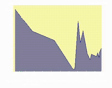
Past trend of total dissolved solids concentration [g l-1] The centre of the lake, 1847-1987 (Q).
F. BIOLOGICAL FEATURES (Q, 1, 3)
F1 FLORA- Emerged macrophytes
Phragmites australis var. communis & flavescens, Schoenoplectus lacustris. - Submerged macrophytes: Potamogeton pectinatus.
- Phytoplankton
Microcystis aeruginosa, Chlamydomonas sp., Chlorella vulgaris, Gyrosigma acuminatum, G. attenuatum, Melosira varians, Navicula rhynchocephala, Synechococcus aeruginosus, Scenedesmus quadricauda, Achnanthes lanceolata. - Attached and benthic algae
Cladophora fracta, Rhizoclonium hieroglyphicum, Enteromorpha intestinalis, Oscillatoria tenuis, O. brevis, O. limosa, Gyrosigma acuminatum, G. attenuatum, Synedra spatulata, Coloneis amphisbaena.
- Zooplankton: Arctodiaptomus salinus, Eucyclops serrulatus, Daphnia magna.
- Benthos: Tanytarsus lauterborni, Crytochironomus fridmanae, Culicoides sp.
- Fish: Cyprinus carpio*, Carassus auratus gibelio*.@
* Economically important.
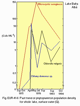
Past trend of phytoplankton population density for whole lake, surface water.
F7 NOTES ON THE REMARKABLE CHANGES OF BIOTA IN THE LAKE IN RECENT YEARS
- The extension of the reed (Phragmites australis) area; yearly invasion of the Potamogeton pectinatus/Cladophora fracta association; the fish species number decreased from 9 (1975-1976) to only 2 (1983-1984).
G. SOCIO-ECONOMIC CONDITIONS (8, 11, 14, 16)
G1 LAND USE IN THE CATCHMENT AREA (1967)- Main species of forest or scrub vegetation
Amygdalus nana, Cerasus fruticosa, Prunus spinosa. - Main species of herbaceous vegetation
Amaranthus albus, A. retroflexus, Artemisia maritima, Brassica campestris, Chenopodium album, Cynodon dactylon, Festuca valesiaca, Koeleria gracilis, Obione pedunculata, Puccinellia distans, Salicornia herbacea, Salsola ruthenica, S. soda, Stipa capillata. - Main kinds of crops
Maize, wheat, sunflower, sugar beet, potato, vegetables, vine, etc. (in decreasing order).
| Main products or major industries |
| Primary industry |
| - Crop production |
| - Fisheries (especially in the Boldu village area) |
| Secondary industry |
| - "Pell-Amar" plant (production of peloid-extract squeezed from lake muds) |
| Population | Population density [km-2] | Major cities (population) | |
|---|---|---|---|
| Rural | 9,000 | 51-100 | None |
H. LAKE UTILIZATION (Q)
H1 LAKE UTILIZATION (1990)- Indoor and outdoor balneotherapy.
By use of lake saline waters and muds, "Pell-Amar" peloid-extract production, sightseeing and tourism, sport-fishing and seasonal seine-fishing.
I. DETERIORATION OF LAKE ENVIRONMENTS AND HAZARDS (Q, 1, 2, 8, 9, 16)
I1 ENHANCED SILTATION- Extent of damage: Not serious.
- Supplementary notes
Silts originate primarily from the erosion of cliffs (since 1984 greatly reduced owing to the lowering of lake water level) and secondarily from the sediment influx via the Boldu Brook.
- Present status: No data.
- Nuisance caused by eutrophication
Unusual algal bloom (Microcystis aeruginosa); summer overgrowth of the submerged macrophyte Potamogeton Pectinatus and the floating algae Cladophora fracta and Spirogyra sp.; Death of fish (carp and "silver" crucian). - Supplementary notes
The lake eutrophication has been accelerated since 1975. Taking into account that aquatic plants and algae (especially Cladophora fracta and Spirogyra sp.) contribute to the formation of therapeutical muds, the use of algicides for other chemical agents) is strictly forbidden. For the same reason, water aeration or weed harvesting is not necessary.
- Extent of damage: None.
-
There are possibilities of degradation of therapeutical sediments by the
following processes.
- Addition of pollutants by the Boldu Brook water, though self-purification processes are detected.
- Enrichment of sandy material due to the erosion of southern shore cliffs. The rate of shore regression was up to 6.4 m yr-1 at higher lake water levels (e. g. before 1984).
- The seasonal use of seine for fishing, which sweeps lake bottom, may disturb the mud formation located within a few centimeters of sediment surface.
- Increase of plankton.consuming fish species invading the lake via the Boldu Brook.
J. WASTEWATER TREATMENTS (8, 16)
J1 GENERATION OF POLLUTANTS IN THE CATCHMENT AREA- (d) Measurable pollution with limited wastewater treatment.
The main source includes the Boldu brook water periodically polluted with the discharge of Boldu village fish ponds, domestic litter disposed by Baile village near the lakeshore, and temporary-settled sheepfolds close to the lake.
- Percentage of rural population with adequate sanitary facilities (on-site
treatment systems): Probably 30%. - Supplementary notes
The balneal spa Balta Alba is fully provided with sanitary facilities.
L. DEVELOPMENT PLANS (Q, 16)
- In order to separate the fishing and the therapeutical mud exploitation areas, the Geological & Mining Inspectorate (Ministry of Geology) proposed in 1984 the construction of an earth dam with a length of ca. 3,700 m; the northern section will be about 2/3 of the central basin and for balneotherapeutic exploitation only, the southern section will be utilized for fishing activities.
M. LEGISLATIVE AND INSTITUTIONAL MEASURES FOR UPGRADING LAKE ENVIRONMENTS (Q, 12, 15, 17)
M1 NATIONAL AND LOCAL LAWS CONCERNED- Names of the laws (the year of legislation)
- Sanitary Law No. 3 (1987)
- Official Norms for Protection of Mineral Therapeutic Resources (1982)
- Responsible authorities
- & (2) Ministry of Geology, Ministry of Health, Ministry of Tourism
- Main items of control
- To supervise all the activities concerning the lake protection and exploitation within the so-called "hydrogeological and sanitary-protected perimeter"; this last perimeter is a major portion of the catchment area, having the strongest influence upon the whole lake.
- To advice all multi-disciplinary studies concerning the lake area.
- To approve measures for upgrading lake environments and to reject inadequate works or activities within the hydrogeological and sanitary- protected perimeter.
- The monitoring, control and restoration in the lake area is carried out by the Geological and Mining Inspection (Ministry of Geology) and the Buzau County Tourism Office (Ministry of Tourism).
- Enterprise for Geological and Geophysical Prospections (I. P. G. G.), Bucharest
- Faculties of Biology, University of Bucharest and University of Cluj
- Institute of Physical Medicine, Balneoclimatology and Medical Recovery (I. M. F. B. R. M.), Bucharest
- Supplementary notes
Since 1983, most intensive studies on the lake area have been carried out by I. P. G. G. in collaboration with the biologists of the Bucharest and Cluj Universities.
N. SOURCES OF DATA
- Questionnaire filled by Geol. Eng. Valentin-Alex. C. Bulgareanu, Enterprise for Geological and Geophysical Prospections, Bucharest, based on the data obtained from the following sources.
- Bulgareanu. V.-A. C. & Teculescu, V. (1979) Uber die limnologischen Bedingungen die die invasionsartige Ausbreitung des Potamogeton pectinatus L. in einigen pelogenen Seen der Ostlichen Rumanischen Ebene begunstingen. Bulgarische Akad. Wiss., Sofia, XIX, Jubilaumstagung Donauforschung, Sep. -Oct. 1976, pp. 503-511.
- Bulgareanu, V.-A. C, Olariu, C., Enache, Gh. & Urcan, T. (1986) New data regarding the limnogeology of the brackish lake Balta Alba (Buzau and Braila districts). Rev. Roum. Geol., Geophys., Geogr., GEOLOGIE, 30: 89- 96.
- Bulgareanu V.-A. C., Ionescu, V., Nastasescu, M. & Ioanitescu, E. (in prep.) Characteristics and dynamics of the peloidogenesis processes in saline lake Balta Alba (Buzau and Braila districts, Romania). Rev. Room. Geol., Geophys., Geogr., GEOLOGIE.
- Ciumpileac, Gh. (1972) Oscillations de niveaux des limans fluviatiles de la vallee du Buzau et de la Ialomitza. Analele Univ. Bucuresti, Geogr., 21: 183-193.*
- Gastescu, P. (1963) The Lakes in P. R. of Romania; Genesis and Hydrologic Regime. 293 pp. P. R. of Romania Acad. Publ. House, Bucharest.*
- Gastescu, P. & Tatiana, N. (1980) Aspects concerning the water balance of the lakes in the north-east Romanian Plain. St. cerc. geol., geofiz., geogr., GEOGRAFIE, 27 (2): 233-242.*
- Gastescu, P. & Gruescu, I. S. (1975) Braila District. 134 pp. R. S. of Romania Acad. Publ. House, Bucharest (in Rom.).
- Ionescu-Teculescu Venera, Bulgareanu, V.-A. C. (1977) The macrophytes of pelogenous lake Balta Alba (Buzau) and their physico-chemical characteristics of the habit. St. cerc. bio., ser. Biol. veget., 29 (2): 87-92.*
- Ionescu-Teculeasu Venera, Bulgareanu V.-A. C. (1978) The development of algal flora of lake Balta Alba (Buzau) in r
