
VARNA LAKE
A lake view from the southeastern shore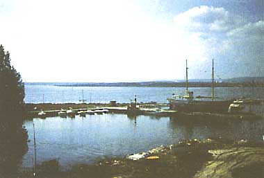 Photo: A. Kurata
A. LOCATION
- Varna, Bulgaria.
- 43:10N, 27:38E; 0.05 m above sea level.
B. DESCRIPTION
-
The Varna Lake,
a lagoon formed at the mouth of the Provadijska River, is the biggest lake
on the Bulgarian Black Sea coast. It is separated from the sea by a continuously
enlarging sand strip 2 km in width. The southern bank of the lake is high
and steep, while the northern bank is slanting. The valley bottom in which
the lake is located is covered by a thick (10-30 m) mud deposit.
The lake is a tectonic unit formed by the rise of sea-level at the end of Pleistocene. The nearby district is characterized by the occurrence of many fault valleys, 30-120 m wide and favored with rich sources of water.
Anavigation channel was constructed across the sand strip in 1909, resulting in the invasion of sea water into the lake. Later on in 1976, the lake was dredged along the river course to put another new navigation route into operation, which is 12 m deep with underwater bank slope. The linkage of the lake with Varna Bay by the two channels enhanced the exchange of water by generating slow currents between the two water bodies, and caused changes in the thermal regime, water quality and ecosystem of the lake.
The lake water level is mainly determined by the change of sea level, and partly by the inflow from the Provadijska and the Devnja River. The salinity of lake water is 11-12 on an average, and the density increases downward from the surface value of 1.0076 to 1.0114 in bottom water. H2S gas is released from bottom layers under 4-5 m depth in summer, owing to decomposition processes and strong thermal stratification.
The completion of the new channel led to the establishment of a large industrial and electric power generation complex and a railway-port-ferry boat centre on the northern bank of Lake Varna. Their impacts on the lake environments are now under study, and some changes such as the increase of anthropogenic sediments have already been recorded. A large amount of silt, containing rich organic matter, pesticides and other pollutants, are supplied via the channels to the bay causing eutrophication and spoiling sand beach recreational areas (2-6, 9).
C. PHYSICAL DIMENSIONS (1)
| Surface area [km2] | 17 |
| Volume [km3] | 0.165 |
| Maximum depth [m] | 19 |
| Mean depth [m] | 9.5 |
| Water level | Unregulated |
| Normal range of annual water level fluctuation [m] | 0.3 |
| Length of shoreline [km] | 32 |
| Residence time [yr] | 0.8 |
| Catchment area [km2] | 2,680 |
D. PHYSIOGRAPHIC FEATURES
D1 GEOGRAPHICAL- Sketch map: Fig. EUR-35-01.
- Names of main islands: None.
- Number of outflowing rivers and channels (name): 2 (navigation channels).
- Climatic data at Varna, 1931-1970
| Mean temp. [deg C] | ||||||||||||
| Jan | Feb | Mar | Apr | May | Jun | Jul | Aug | Sep | Oct | Nov | Dec | Ann. |
|---|---|---|---|---|---|---|---|---|---|---|---|---|
| 1.2 | 2.5 | 5.1 | 10.1 | 15.4 | 20.1 | 22.6 | 22.4 | 19.0 | 13.9 | 9.1 | 4.0 | 12.0 |
| Precipitation [mm] | ||||||||||||
| 37 | 35 | 30 | 38 | 42 | 53 | 38 | 36 | 28 | 39 | 52 | 52 | 480 |
- Number of hours of bright sunshine: 2,094 hr yr-1.
- Solar radiation: 24.5 MJ m-2 day-1.
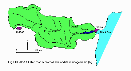
Sketch map of Varna Lake and its drainage basin (Q).
- Water temperature [deg C](8)
| Varna, 1988 | ||||||||||||
| Depth [m] | Jan | Feb | Mar | Apr | May | Jun | Jul | Aug | Sep | Oct | Nov | Dec |
|---|---|---|---|---|---|---|---|---|---|---|---|---|
| 0.5 | 8.0 | 7.2 | 14 | - | - | - | - | - | - | - | - | - |
- Mixing type: Dimictic.
- Notes on water mixing and thermocline formation
The summer thermocline is displaced 6 to 10 m below the water surface. There is an isothermal regime during the winter time.
E. LAKE WATER QUALITY
E1 TRANSPARENCY [m](8, 9)| Varna, 1987-1988 | ||||||||||||
| Depth [m] | Jan | Feb | Mar | Apr | May | Jun | Jul | Aug | Sep | Oct | Nov | Dec |
|---|---|---|---|---|---|---|---|---|---|---|---|---|
| 0.02 | - | 0.26 | 0.25 | - | 0.21 | 0.20 | - | - | 0.20 | - | 0.21 | |
| Varna, 1987-1988 | ||||||||||||
| Depth [m] | Jan | Feb | Mar | Apr | May | Jun | Jul | Aug | Sep | Oct | Nov | Dec |
|---|---|---|---|---|---|---|---|---|---|---|---|---|
| 0.5 | 7.6 | 8.4 | 9.5 | - | - | - | - | - | - | - | - | - |
| Varna, 1988 | ||||||||||||
| Depth [m] | Jan | Feb | Mar | Apr | May | Jun | Jul | Aug | Sep | Oct | Nov | Dec |
|---|---|---|---|---|---|---|---|---|---|---|---|---|
| 0.5 | 400 | 1,210 - | - | - | - | - | - | - | - | - | - | |
| Varna, 1988 | ||||||||||||
| Depth [m] | Jan | Feb | Mar | Apr | May | Jun | Jul | Aug | Sep | Oct | Nov | Dec |
|---|---|---|---|---|---|---|---|---|---|---|---|---|
| 0.5 | 5.9 | 5.6 | 8.0 | - | - | - | - | - | - | - | - | - |
- NH4-N [mg l-1]
| Varna, 1987-1988 | ||||||||||||
| Depth [m] | Jan | Feb | Mar | Apr | May | Jun | Jul | Aug | Sep | Oct | Nov | Dec |
|---|---|---|---|---|---|---|---|---|---|---|---|---|
| 0.5 | 11.3 | 28.9 | 8.0 | 9.9 | - | - | 6.8 | 6.2 | 6.5 | - | 8.6 | - |
- NO3-N [mg l-1]
| Varna, 1987-1988 | ||||||||||||
| Depth [m] | Jan | Feb | Mar | Apr | May | Jun | Jul | Aug | Sep | Oct | Nov | Dec |
|---|---|---|---|---|---|---|---|---|---|---|---|---|
| 0.5 | 7.5 | 3.7 | - | 14.5 | - | - | 3.0 | - | 2.9 | - | - | - |
| Varna, 1988 | ||||||||||||
| Depth [m] | Jan | Feb | Mar | Apr | May | Jun | Jul | Aug | Sep | Oct | Nov | Dec |
|---|---|---|---|---|---|---|---|---|---|---|---|---|
| 0.5 | - | - | - | - | 300 | - | - | - | - | - | - | - |
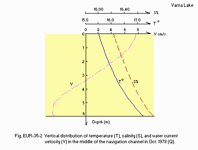
Vertical distribution of temperature (T), salinity (S), and water current velocity (V) in the middle of the navigation channel in October 1978 (Q).
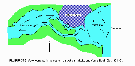
Water currents in the eastern part of Varna Lake and Varna Bay in October 1978 (Q).
F. BIOLOGICAL FEATURES
F1 FLORA- Emerged macrophytes: Phragmites communis.
- Submerged macrophytes (6)
- Phytoplankton
Zostera marina, Acrorhynchus reprobatus, Ardissonia sp., Chara spp., Cladophora spp., Enteromorpha intestinalis.
Anabaenopsis arnoldii, Cerataulina bergoni, Ceratium furca, Chaetoceros curvisetus, Erbia tripatita, Leptocylyndrus danicus, Peridinium steini, Coscinosira oestrupii, Ditylum brightwellii, Thalassiosira subsalina, Cerataulina bergonii, Exuviella cordata, Gonyaulax polyedra.
- Zooplankton
- Benthos
- Fish (1)
- Supplementary notes on the biota: Since the water salinity is 11-12 , the
Alona rectangila, Brachyonus angularis, Cercopasis pengoi, Acartia clausii, Centrogages kroervi, Oithona nana, Penila avirostris, Acartia sp., Ostoumovia inkermamica, Podon ovum, Synchaeta cecilia.
Canalus helgoglandicus, Evadne nordmanni, Oikopleura dioica, Pseudocalanus elongatus, Alona rectangula, Balanus eburneus, Campanulina pontica, Hydrobia acuta, Lindia tegusa, Nais elinguis, Rissoa lineolara.
Anguilla anguilla, Clupeonella delicatula, Engraulis encrasicholus ponticus, Lucioperca lucioperca.
lake ecosystem comprises freshwater species as well as salt and brackish water species.
- Fishery products other than fish
Shrimp, mussel, small fish, stripe.
G. SOCIO-ECONOMIC CONDITIONS
G1 LAND USE IN THE CATCHMENT AREA (2)| 1985 | ||
| Area[km2] | [%] | |
|---|---|---|
| - Agricultural land | ||
| Crop field | 2,117.3 | 79 |
| Pasture land | 80.4 | 3 |
| - Others | 482.4 | 18 |
| - Total | 2,680.1 | 100 |
| * The catchment area is highly developed. | ||
- Main types of woody vegetation: Oak, fruit gardens.
- Levels of fertilizer application on crop fields: Moderate.
| 1985 | ||
| No. of persons engaged [%] | Main products or major industries | |
|---|---|---|
| Primary industry | 51 | |
| Secondary industry | 24 | Power generation, ship building, electronics, chemistry, textile, food industry |
| Tertiary industry | 25 | Tourism |
- Number of domestic animals in the catchment area
Cattle 25,000, sheep 360,000 swine 220,000, poultry 1,300,000, bee-keeping 25,000 families.
| 1987 | |||
| Population | Population density [km-2] | Major cities (population) | |
|---|---|---|---|
| Urban | 418,000 | ||
| Rural | 82,000 | 187 | Varna, Devnja, Provadis |
| Total | 500,000 | ||
H. LAKE UTILIZATION
H1 LAKE UTILIZATION (2) 1985- Navigation and transportation (cargo 35,000,000 metric tons per year),
sightseeing (no. of visitors: 2,500,000 per year), recreation and fisheries.
I. DETERIORATION OF LAKE ENVIRONMENTS AND HAZARDS
I1 ENHANCED SILTATION- Extent of damage: Serious.
- Supplementary notes
The dredging of the lake along the river course has become necessary because of high anthropogenetic sediment inflow. The other source of sediment is very intensive surface soil erosion in the catchment area. The opening of the two navigation channels enforced meso-scale water currents by which the light particles are washed out from the lake to pollute the bay and beaches.
- Present status: Serious.
- Environmental quality standards for contaminants in the lake: Present.
- Food safety standards or tolerance limits for toxic contaminants in the
lakes: Present.
- Nuisance caused by eutrophication
- Supplementary notes
Unusual algal bloom. Cyanophyta, Chlorophyta, Chlamydomonas, Bacillariophyta.
Eutrophication is in progress year after year, giving damage to tourism. City beaches and ports are badly polluted.
- Extent of damage: None.
- Supplementary notes
There is much limestone in the catchment area.
J. WASTEWATER TREATMENTS
J1 GENERATION OF POLLUTANTS IN THE CATCHMENT AREA- d) Measurable pollution with limited wastewater treatment.
- Percentage of municipal population in the catchment area provided with
- Municipal wastewater treatment systems
- Industrial wastewater treatment systems
adequate sanitary facilities (on-site treatment systems) or public sewerage: 12%.
No. of secondary treatment systems: 3.
No. of industrial wastewater treatment systems: 2.
K. IMPROVEMENT WORKS IN THE LAKE
K1 RESTORATION- Bank protection, channel dredging.
L. DEVELOPMENT PLANS
- Since mid-sixties an intensive development plan has been put in operation.
It includes ship building and other industrial development, enlargement
of the port, etc.
M. LEGISLATIVE AND INSTITUTIONAL MEASURES FOR UPGRADING LAKE ENVIRONMENTS
M1 NATIONAL AND LOCAL LAWS CONCERNED- Names of the laws (the year of legislation)
- The law for the water, air and soil protection from pollution (1963)
- The law for the environment protection (1967) (3)The law for water (1969)
- Responsible authorities
- Local authority
- Ministry of Energetics
- Ministry of Agriculture and Forestry
- Main items of control
- The quality and quantity of water inflow
- The quality of water outflow
- The rate of sedimentation
- State Committee for Environment Protection
- Local authority
- Ministry of Health
- Bulgarian Academy of Sciences
- Institute on Oceanography, Varna
- Institute for Hydrology and Meteorology, Sofia
- Environment Protection Research Centre, Sofia
N. SOURCES OF DATA
- Questionnaire filled by Dr. G. Gergov, Institute for Hydrology and Meteorology, Sofia, Bulgaria, based on the following sources.
- Handbook of the Bulgarian Rivers, Vol. I (1957), II (1958), XVI (1964). Science and Art, Sofia.
- Statistical Year Book for Bulgaria (1986) Sofia.
- Veselinov, V. & Gergov, G. (1980) First results from studies of the bay lakes hydrocomplex in the vicinity of Varna city. J. Hydrol. & Meteorol., 4: 21-26.
- Evstatiev, D. & Manov, G. (1988) Engineering Geological Characteristics of Varna Lake Valley. 121 pp. BAS, Sofia.
- Gochev, P. (1934) Geological remarks on the Varna Lake area. J. Bulg. Geol. Soc., 6 (1): 31-65.
- Geography of Bulgaria, Physical Geography (1982) 513 pp. BAS, Sofia.
- Handbook of Bulgarian Climate, vol. I-V. Science and Art, Sofia.
- The State Committee for Environment Protection: Bulletin about the surface water condition.
- Rojdestvenski, A. (1987) The Black Sea lakes. "Black Sea", Varna.
