LAKE STECHLIN
A view on the lake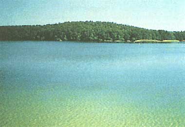
Photo: W. Scheffler
A. LOCATION
- Potsdam, East Germany.*
- 53:10N, 13:02E; 59.7 m above sea level.
* Place names are not updated.
B. DESCRIPTION
-
Lake Stechlin with its large number of bights was formed by deep melting of dead ice blocks and erosion of melt water channels after the Weichselian stage of the last glaciation. It is situated in the outwash plain immediately to the south of the terminal moraine of the Furstenberger Staffel. Formations of gravel and sand deposits reaching heights up to 84.5 m above the sea level and approaching the shores are towards the northeast of the lake.
Lake Stechlin has an area of 4.3 km2, a maximum depth of 68 m, and is stratified in summer with small hypolimnetic oxygen depletion. Towards the west and southwest, a sand plain follows at heights of 70-80 m above the sea level bordered on the east by a ground moraine. Before 1750, surface in- or effluents were virtually absent. The natural real surface catchment area amounts to 12.4 km2 of which 80% are covered by forests. The actual sub-surf ace catchment area amounts 26.0 km2. The actual water level is 59.7 m above the sea level. Before 1750, it was 60.7 m.
The lake is locally cut deeply into its environs with considerably steep shores on the northwest and northeast sides of the north bay. The Fenchelberg, the highest point (84.5 m a.s.l.) of the Lake Stechlin area, is situated immediately on its northeast shore.
The lake is divided in four basins or bays: the north basin with the maximum depth of the whole lake (68 m); the relatively shallow central basin, 59 m deep; the west basin influenced directly by the cooling water circuit, 41 m deep and separated from the south basin (35 m) by a nearly 1.2 km long peninsula stretching from west to east. During the stagnation phases the hypolimnion of the different basins is not changeable mutually. The volumes of the four basins are: west basin 19,000,000 m3, north basin 37,000,000 m3, south basin 13,000,000 m3, central basin 28,000,000 m3.
The shore of Like Stechlin is bounded by a more or less closed large zone of mixed forests mainly consisting of pines, beeches, willows and alders. Allochthonous input of organic matter - mostly leaves, twigs, pollen and fruits from the surrounding trees - are potentially significant for material balance and production in the lake. Open land borders on the shores up to 4.8% only and the trophic level of the lake water is still oligotrophic. Now the input of cooling water circuit from a nuclear power plant and the man-made surface run-in of water from Lake Dagow influence mainly the ecosystem (1).
C. PHYSICAL DIMENSIONS (1)
| Surface area [km2] | 4 |
| Volume [km3] | 0.0969 |
| Maximum depth [m] | 68 |
| Mean depth [m] | 22.8 |
| Water level | Regulated |
| Length of shoreline [km] | 16.1 |
| Catchment area [km2] | 26 |
D. PHYSIOGRAPHIC FEATURES
D1 GEOGRAPHICAL- Sketch map: Fig. EUR-31-01.
- Bathymetric map: Fig. EUR-31-02.
- Names of main islands: None (1).
- Number of outflowing rivers and channels (name): 1 (Polzow Canal)(2).
- Climatic data at Neuglobsow
| Mean temp. [deg C]*1 | ||||||||||||
| Jan | Feb | Mar | Apr | May | Jun | Jul | Aug | Sep | Oct | Nov | Dec | Ann. |
|---|---|---|---|---|---|---|---|---|---|---|---|---|
| -0.9 | -0.5 | 2.4 | 6.7 | 12.1 | 15.6 | 17.3 | 16.2 | 12.7 | 8.2 | 3.6 | 0.6 | 7.9 |
| Precipitation [mm]*2 | ||||||||||||
| 41 | 32 | 34 | 45 | 58 | 60 | 76 | 57 | 45 | 41 | 51 | 53 | 593 |
| *1 1901-1980 (3). *2 1958-1981 (4). | ||||||||||||
- Solar radiation (1967-1976): 9.6 MJ m-2 day-1 (5).
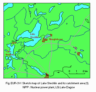
Sketch map of the lake and its catchment area (1).
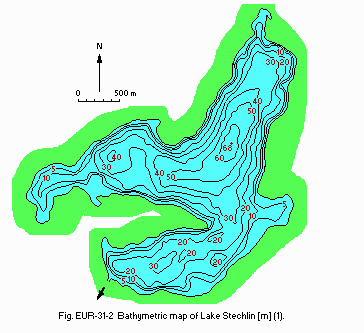
Bathymetric map [m](1).
- Water temperature [deg C](6)
| Depth [m] | Jan | Feb | Mar | Apr | May | Jun | Jul | Aug | Sep | Oct | Nov | Dec |
|---|---|---|---|---|---|---|---|---|---|---|---|---|
| 0 | 2.8 | 1.9 | 2.4 | 5.0 | 10.4 | 16.9 | 18.7 | 18.8 | 16.9 | 12.8 | 8.5 | 5.0 |
| 6 | 3.2 | 2.3 | 2.6 | 4.6 | 9.2 | 14.2 | 17.4 | 18.3 | 16.6 | 12.8 | 8.5 | 5.1 |
| 10 | 3.3 | 2.5 | 2.6 | 4.4 | 7.2 | 9.2 | 10.7 | 13.0 | 14.7 | 12.7 | 8.5 | 5.2 |
| 16 | 3.4 | 2.7 | 2.7 | 4.1 | 5.6 | 6.1 | 6.4 | 6.7 | 6.8 | 7.0 | 7.8 | 5.2 |
| 20 | 3.5 | 2.8 | 2.8 | 4.0 | 5.2 | 5.6 | 5.8 | 5.9 | 6.0 | 6.1 | 6.5 | 5.2 |
| 30 | 3.6 | 3.0 | 2.9 | 3.9 | 4.7 | 4.9 | 5.1 | 5.1 | 5.1 | 5.2 | 5.2 | 5.0 |
| 40 | 3.7 | 3.2 | 2.9 | 3.8 | 4.5 | 4.7 | 4.8 | 4.9 | 4.9 | 4.9 | 4.9 | 4.8 |
- Freezing period: January-early May (6).
- Mixing type: Dimictic (6).
E. LAKE WATER QUALITY
E1 TRANSPARENCY [m](7)-
1982: 7.7 (5.2-9.9).
-
8.1-8.3.
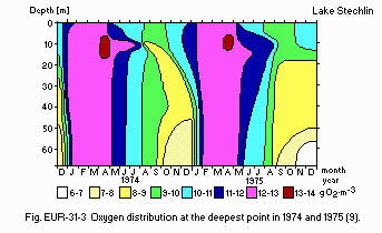
Oxygen distribution at the deepest point in 1974 and 1975.
E6 CHLOROPHYLL CONCENTRATION (8)
- Chlorophyll a [micro g l-1]: 1.
- NH4-N [micro g l-1]: Fig. EUR-31-04.
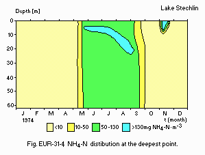
NH4-N distribution at the deepest point.
- NO3-N [micro g l-1]: Fig. EUR-31-05.
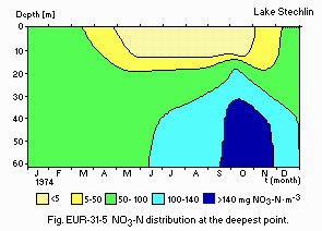
NO3-N distribution at the deepest point.
E8 PHOSPHORUS CONCENTRATION (11)
- PO4-P [micro g l-1]: Fig. EUR-31-06 and 07.
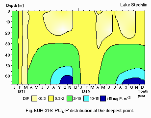
PO4-P distribution at the deepest point.
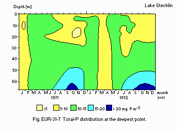
Total-P distribution at the deepest point.
E1O PAST TRENDS
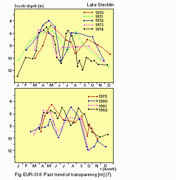
Past trend of transparency [m](7).
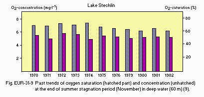
Past trends of oxygen saturation (hatched part) and concentration (unhatched) at the end of summer stagnation period (November) in deep water (60 m)(9).
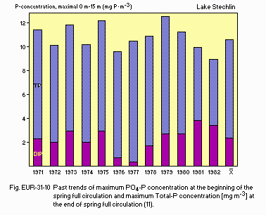
Past trends of maximum PO4-P concentration at the beginning of the spring full circulation and maximum Total-P concentration [micro g l-1] at the end of spring full circulation (11).
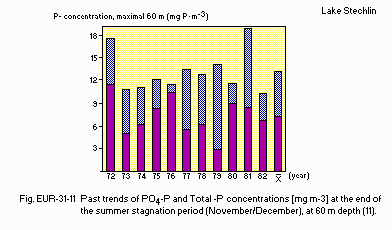
Past trends of PO4-P and Total-P concentrations [micro g l-1] at the end of the summer stagnation period (November/December), at 60 m depth (11).
F. BIOLOGICAL FEATURES
F1 FLORA- Emerged macrophytes (12)
Cladium mariscus, Carex acutiformis, Thelypteris palustris, Phragmites australis, Typha angustifolia, Equisetum fluviatile, Sparganium minimum, Hydrocharis morsusranae. - Floating macrophytes: Lemna minor, L. trisulca, Spirodela polyrhiza (12).
- Submerged macrophytes (12)
Utricularia vulgaris, Ceratophyllum demersum, Chara fragilis, C. vulgaris, C. aspera, Myriophyllum spicatum, Nitellopsis obtusa. - Phytoplankton (13)
Anabaena lemmermannii, Asterionella formosa, Chrysamoeba radians, Cyclotella kutzingiana, Dinobryon bavaricum, D. cylindricum, Mallomonas fastigata, Oscillatoria rubescens, Scenedesmus costato-granulatus, Synedra acus, Crucigenia quadrata.
- Zooplankton (14)
Eudiaptomus gracilis, Eurytemora lacustris, Daphnia cucullata, Synchaeta pectinata, Ascomorpha ecaudis, Pompholyx sulcata, Polyarthra dolichoptera, Conochilus unicornis, Filinia terminalis, Keratella cochlearis, Kellicottia longispina. - Benthos (15)
Pisidium conventus, Sergentia coracina, Stictochironomus rosenscholdi, S. histrio, Enallagma cyathigerum, Coenagrion puella, C. pulchellum. - Fish (16)
Abramis brama, Anguilla anguilla, Coregonus albula, Cyprinus carpio, Esox luceus, Rutilus rutilus, Perca fluviatilis, Tinca tinca, Lucioperca lucioperca.
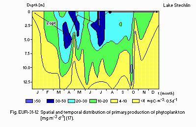
Spatial and temporal distribution of primary production of phytoplankton [mg m-3 d-1](17).
F4 BIOMASS: Fig. EUR-31-13.
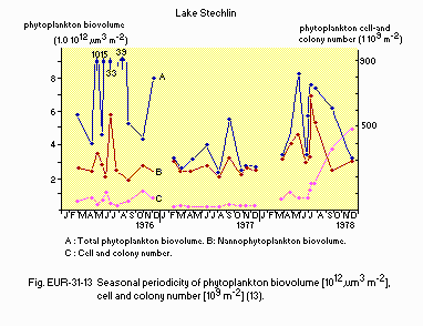
Seasonal periodicity of phytoplankton biovolume [trill. micro m3 m-2], cell and colony number [bill. m-2](13).
F5 FISHERY PRODUCTS: Fig. EUR-31-14.
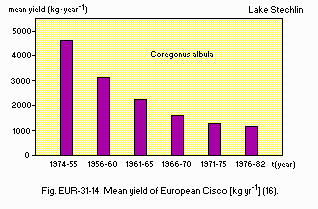
Mean yield of European Cisco [kg yr-1](16).
F6 PAST TRENDS: Fig. EUR-31-15 (17).
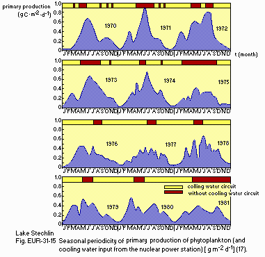
Seasonal periodicity of primary production of phytoplankton (and cooling water input from the nuclear power station)[g m-2 d-1].
F7 NOTES ON THE REMARKABLE CHANGES OF BIOTA IN THE LAKE IN RECENT YEARS
-
In 1966 the first nuclear power plant in the G. D. R. was put into operation
with an external circulation of its cooling water taken from Lake Nehmitz.
The heated water is then introduced into Lake Stechlin (Fig. EUR-31-17).
The phenomena observed concerning the phytoplanktonic community after the start of the nuclear power plant operation (1966) can be summed up as follows. The phytoplanktonic periodicity corresponds well with the cooling water circulation. When the nuclear power plant is in operation the spring development of phytoplankters starts nearly six weeks earlier than under natural conditions. Every interruption of the cooling water circulation is followed by a break of continuity of phytoplankton development (13).
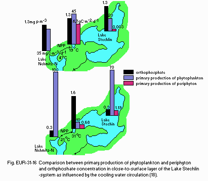
Comparison between primary production of phytoplankton and periphyton and orthphosphate concentration in close-to-surface layer of the Lake Stechlin- system as influenced by the cooling water circulation (18).
Average annual production of macrozoobenthos in the west basin before and after the nuclear power plant has become operational (18).
| Macrozoobenthos | Before operation (mg ww m-2 yr-1) | After operation (mg ww m-2 yr-1) | Relative change (%) |
|---|---|---|---|
| Pisidium conventus | 54 | 263 | 487 |
| Oligochaeta | 589 | 3,106 | 527 |
| Sergentia coracina | 141 | 778 | 552 |
| Tanytarsini | 363 | 287 | 79 |
| Total | 1,147 | 4,434 | 387 |
| *ww: wet weight. | |||
G. SOCIO-ECONOMIC CONDITIONS
G1 LAND USE IN THE CATCHMENT AREA (19)- Main types of woody vegetation
Evergreen conifer forest (Pinus sylvestris).
| 1989 | |||
| Population | Population density [km-2] | Major cities (population) | |
|---|---|---|---|
| Total | 1,095 | 42.1 | None (415,000 visitors during summer season, in 1980) |
H. LAKE UTILIZATION
H1 LAKE UTILIZATION (8, 21)-
Source of water, cooling water circulation, sightseeing and tourism,
recreation (swimming, sport-fishing, yachting) and fisheries.
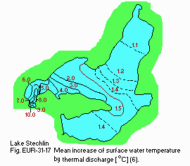
Mean increase of surface water temperature by thermal discharge [deg C](6).
Lake Stechlin area: trend in recreation-days (8)
| Holiday-makers | Short-time | Diving centre | |
|---|---|---|---|
| Year | overnight | visitors | visitors |
| 1963 | 60,000 | 10,000 | - |
| 1975 | 230,000 | 40,000 | - |
| 1980 | 350,000 | 60,000 | 5,000 |
| 1982 | |
| Use rate [m3 day-1] | |
|---|---|
| - Domestic | |
| Drinking (Neuglobsow) | N.A. |
| - Power plant (cooling) | 400,000 |
I. DETERIORATION OF LAKE ENVIRONMENTS AND HAZARDS
I1 ENHANCED SILTATION (1, 8)- Extent of damage: None.
- Present status: None.
- Nitrogen and phosphorus loadings to the lake
1981, 1982
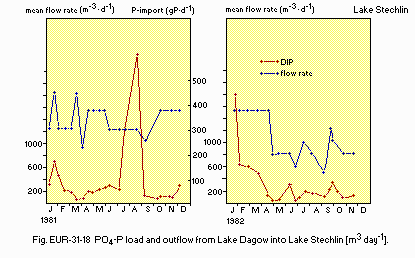
PO4-P load and outflow from Lake Dagow into Lake Stechlin [m3 day-1].
I4 ACIDIFICATION (8, 12)
- Extent of damage: None.
J. WASTEWATER TREATMENTS (11)
J1 GENERATION OF POLLUTANTS IN THE CATCHMENT AREA-
c) Limited pollution with wastewater treatment.
K. IMPROVEMENT WORKS IN THE LAKE
K3 OTHERS (8)-
Sewage diversion in the catchment area (1985).
L. DEVELOPMENT PLANS (1, 8)
-
None.
M. LEGISLATIVE AND INSTITUTIONAL MEASURES FOR UPGRADING LAKE ENVIRONMENTS
M1 NATIONAL AND LOCAL LAWS CONCERNED (8)- Main items of control
Toxic substances in the effluents (phenols, detergents, Cu, Cr, Pb, As, Zn, Cd, Co, Ni, Hg, polycyclic aromatic hydrocarbons, organophosphoric hydrocarbons, fluoride). Pollutants in the effluents (N, P, BOD salinity, Ca, Mg, Na, chloride, sulphate, hardness, Fe, Mn, pH-value). Bacteriological criteria (coliforms, enterococci).
- Limnological Laboratory Stechlin
- Hydrometorological Station of Meterological Service
- Ministry of Higher Education
- Ministry of Environment and Water Management
- Academy of Science
- Department of Water Science of Technology, University Dresden
- Institute of Water Management, Berlin
N. SOURCES OF DATA
- Questionnaire prepared by the editors with the support of Dr. W. Scheffler, Akademie der Wissenschaften der DDR, Zentralinstitut fur Mikrobiologie und Experimentelle Therapie, Jena, DDR, based on the following sources.
- Krey, L. (1985) The lakes of the Lake Stechlin area: aspects of their morphometry. "Lake Stechlin" (ed. Casper, S. J.), pp. 29-40. Dr W. Junk Publishers, Dordrecht.
- Krey, L. (1985) Morphology and morphogenesis of the Lake Stechlin area. Ibid., pp. 7-10.
- Richter, D. (1985) Climatic conditions. Ibid., pp. 41-47.
- Richter, D. (1985) Water balance components. Ibid., pp. 67-72.
- Richter, D. (1985) Heat balance components. Ibid., pp. 56-64.
- Richter, D. (1985) Water temperature. Ibid., pp. 47-56.
- Koschel, R. (1985) Light penetration. Ibid., pp. 72-86.
- Klapper, H. & Koschel, R. (1985) Lake Stechlin area and society. Ibid., pp. 455-483.
- Mothes, G. & Koschel, R. (1985) The oxygen budget. Ibid., pp. 118-125.
- Mothes, G & Koschel, R. (1985) The nitrogen budget. Ibid., pp. 111-116.
- Koschel, R. & Mothes, G. (1985) The phosphorus budget. Ibid., pp. 87- 101.
- Krausch, H.-D. (1985) Aquatic macrophytes in the Lake Stechlin area. Ibid., pp. 129-149.
- Casper, S. J. (1985) The phytoplankton. Ibid., pp. 157-195.
- Ronneberger, D. & Kasprzak, P. (1985) The zooplanktonic population. Ibid., pp. 243-259.
- Mothes, G. (1985) The macrozoobenthos. Ibid., pp. 230-243.
- Ronneberger, D. (1985) Fish. Ibid., pp. 261-269.
- Koschel, R. (1985) The primary production of the phytoplankton. Ibid., pp. 287-314.
- Koschel, R., Mothes, G. & Casper, S. J. (1985) The nuclear power plant and its role in the life of Lake Stechlin. Ibid., pp. 419-429.
- Krausch, H.-D. (1985) The plant cover of the Lake Stechlin area. Ibid., pp. 11-15.
- (1989) Personal communication.
- Krausch, H.-D. (1985) Settlement and economy of the Lake Stechlin area. Ibid., pp. 15-18.
- Casper, S. J. (1985) The Limnological Laboratory Stechlin and the Lake Stechlin research project. Ibid., pp. 19-24.


