
STARNBERGER SEE
A view on the lakeshore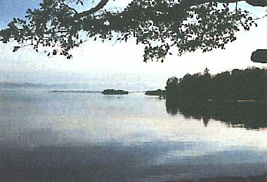
Photo: B. Lenhart
A. LOCATION
- Bayern, West Germany.*
- 47:47-47:48N, 11:16-11:21E; 584.2 m above sea level.
* Place names are not updated.
B. DESCRIPTION
-
Lake Starnberger (the second widest of Bavaria) is located 20 km north to the northern periphery of the Alps and was formed during the last glacial period ("Isar-Loisach-glacier") some 15,000-20,000 years ago. With a maximum depth of 128 m and a volume of about 3 billion m2 Lake Starnberger is the greatest water body of Bavaria. The lake measures 20 km from north to south and reaches an average width of 2.8 km. The catchment area is 5.6 times as large as the lake itself. The water residence time is about 21 years since only a few small rivers flow into the lake (danger of eutrophication). Thirty-six% of the catchment area consist of woody vegetation - half is afforested plantation of conifers (Picea, Pinus) and half is mixed deciduous forest consisting mostly of beech (Fagus sylvatica). Additional 46% are farmlands (67% pasture land, 33% crop field). Surrounding settlements are mostly rural with Starnberg (located at the lake outlet) being the largest city with 17,000 inhabitants. As Munich, the capital of Bavaria with a population of 1.5 million is situated nearby (15 km), the area is much frequented for recreation activities. The originally oligotrophic lake has been influenced by economic development since the 1950's by nutrient loading of municipal sewage. The installation of a circular sewer line system from 1964 to 1976 and a treatment plant at the lake outlet improved the water quality tremendously, so that Lake Starnberger can now be called mesotrophic with a tendency to oligotrophic (Q1, Q2).
C. PHYSICAL DIMENSIONS (1)
| Surface area [km2] | 56 |
| Volume [km3] | 2.9989 |
| Maximum depth [m] | 127.8 |
| Mean depth [m] | 53.2 |
| Water level | Unregulated |
| Normal range of annual water level fluctuation [m] | 0.3 |
| Length of shoreline [km] | 49.2 |
| Residence time [yr] | ca. 21 |
| Catchment area [km2] | 258 |
D. PHYSIOGRAPHIC FEATURES
D1 GEOGRAPHICAL- Bathymetric map: Fig. EUR-24-01.
- Names of main islands: Roseninsell (0.0169 km2)(1).
- Number of outflowing rivers and channels (name): 1 (Wurm R.)(1).
- Climatic data near the lake, 1931-1960 (3)
| Mean temp. [deg C]*1 | ||||||||||||
| Jan | Feb | Mar | Apr | May | Jun | Jul | Aug | Sep | Oct | Nov | Dec | Ann. |
|---|---|---|---|---|---|---|---|---|---|---|---|---|
| -2.2 | -1.1 | 2.9 | 7.2 | 11.6 | 15.0 | 16.8 | 16.4 | 13.4 | 8.0 | 3.2 | -0.7 | 7.5 |
| Precipitation [mm]*2 | ||||||||||||
| 72 | 66 | 63 | 71 | 125 | 137 | 159 | 117 | 93 | 75 | 64 | 59 | 1,101 |
| *1 Ammerland. *2 Starnberg. | ||||||||||||
- Number of hours of bright sunshine: ca. 950-980 hr yr-1 (Q1).
- Solar radiation (Hohenpei enberg, 1978-1979): 11.1 MJ m-2 day-1 (Q1).
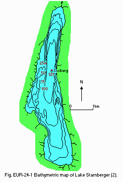
Bathymetric map (2).
- Water temperature [deg C](Q1, 1)
| Seeburg, December 1977-December 1979 | ||||||||||||
| Depth [m] | Jan | Feb | Mar | Apr | May | Jun | Jul | Aug | Sep | Oct | Nov | Dec |
|---|---|---|---|---|---|---|---|---|---|---|---|---|
| 0 | 3.9 | 3.1 | 3.5 | 4.4 | 9.6 | 17.6 | 17.3 | 19.3 | 16.7 | 13.3 | 8.8 | 5.8 |
| 2 | 4.0 | 3.1 | 3.5 | 4.4 | 9.3 | 17.4 | 16.9 | 19.1 | 16.6 | 13.1 | 8.8 | 5.8 |
| 4 | 4.0 | 3.2 | 3.5 | 4.4 | 9.1 | 17.2 | 16.5 | 18.8 | 16.4 | 13.0 | 8.8 | 5.8 |
| 6 | 4.1 | 3.3 | 3.5 | 4.4 | 9.1 | 15.5 | 15.9 | 18.2 | 16.1 | 13.0 | 8.8 | 5.8 |
| 8 | 4.1 | 3.3 | 3.5 | 4.2 | 8.9 | 13.0 | 14.7 | 16.8 | 15.8 | 13.0 | 8.8 | 5.8 |
| 10 | 4.1 | 3.3 | 3.5 | 4.2 | 8.4 | 12.0 | 13.4 | 15.0 | 15.3 | 13.0 | 8.8 | 5.8 |
| 13 | 4.1 | 3.3 | 3.5 | 4.2 | 7.7 | 9.9 | 10.3 | 11.0 | 13.0 | 11.6 | 8.8 | 5.8 |
| 16 | 4.1 | 3.4 | 3.6 | 4.2 | 6.6 | 8.1 | 7.8 | 8.9 | 9.1 | 9.0 | 8.7 | 5.8 |
| 20 | 4.1 | 3.4 | 3.6 | 4.2 | 6.0 | 7.1 | 6.4 | 6.7 | 7.1 | 6.7 | 7.2 | 5.8 |
| 25 | 4.2 | 3.4 | 3.6 | 4.2 | 5.6 | 6.0 | 5.8 | 6.3 | 6.1 | 5.8 | 6.3 | 5.8 |
| 30 | 4.2 | 3.4 | 3.6 | 4.2 | 5.2 | 5.4 | 5.4 | 5.6 | 5.4 | 5.2 | 5.8 | 5.7 |
| 40 | 4.2 | 3.6 | 3.6 | 4.2 | 4.8 | 5.0 | 5.0 | 5.1 | 5.2 | 5.0 | 5.1 | 5.4 |
| 50 | 4.3 | 3.6 | 3.7 | 4.1 | 4.6 | 4.7 | 4.7 | 4.7 | 4.7 | 4.7 | 4.7 | 5.3 |
| 75 | 4.3 | 3.7 | 3.7 | 4.1 | 4.3 | 4.4 | 4.4 | 4.4 | 4.3 | 4.5 | 4.5 | 4.8 |
| 100 | 4.3 | 3.7 | 3.8 | 4.0 | 4.2 | 4.2 | 4.3 | 4.3 | 4.2 | 4.3 | 4.3 | 4.7 |
| 117 | 4.3 | 3.9 | 3.7 | 4.0 | 4.1 | 4.1 | 4.2 | 4.1 | 4.2 | 4.2 | 4.2 | 4.4 |
- Freezing period: Surface frozes once every 6-10 years in February-March (1).
- Mixing type: Dimictic (1).
- Notes on water mixing and thermocline formation: Potentially meromictic (1).
E. LAKE WATER QUALITY (Q1)
E1 TRANSPARENCY [m]| Seeburg, 1978-1979 | ||||||||||||
| Depth [m] | Jan | Feb | Mar | Apr | May | Jun | Jul | Aug | Sep | Oct | Nov | Dec* |
|---|---|---|---|---|---|---|---|---|---|---|---|---|
| 13.0 | 13.4 | 8.4 | 9.6 | 6.2 | 10.1 | 5.5 | 3.3 | 5.3 | 7.6 | 10.1 | 10.4 | |
| * 1977-1979. | ||||||||||||
| Seeburg, 1978-1979 | ||||||||||||
| Depth [m] | Jan | Feb | Mar | Apr | May | Jun | Jul | Aug | Sep | Oct | Nov | Dec* |
|---|---|---|---|---|---|---|---|---|---|---|---|---|
| 0 | 8.2 | 8.0 | 8.1 | 8.3 | 8.4 | 8.7 | 8.8 | 8.8 | 8.7 | 8.6 | 8.4 | 8.2 |
| 2 | 8.0 | 7.9 | 8.1 | 8.3 | 8.5 | 8.8 | 8.8 | 8.8 | 8.7 | 8.5 | 8.4 | 8.2 |
| 4 | 8.0 | 7.9 | 8.1 | 8.3 | 8.5 | 8.8 | 8.8 | 8.8 | 8.7 | 8.5 | 8.4 | 8.2 |
| 6 | 8.0 | 7.9 | 8.1 | 8.3 | 8.5 | 8.8 | 8.8 | 8.8 | 8.7 | 8.5 | 8.4 | 8.2 |
| 8 | 8.0 | 7.9 | 8.1 | 8.3 | 8.5 | 8.7 | 8.7 | 8.7 | 8.7 | 8.5 | 8.4 | 8.2 |
| 10 | 8.0 | 7.9 | 8.1 | 8.3 | 8.5 | 8.6 | 8.6 | 8.7 | 8.6 | 8.5 | 8.4 | 8.2 |
| 13 | 8.0 | 7.9 | 8.2 | 8.3 | 8.5 | 8.5 | 8.3 | 8.3 | 8.3 | 8.4 | 8.4 | 8.2 |
| 16 | 8.0 | 7.9 | 8.2 | 8.3 | 8.4 | 8.3 | 8.2 | 8.1 | 8.0 | 8.0 | 8.3 | 8.2 |
| 20 | 8.0 | 7.9 | 8.2 | 8.4 | 8.3 | 8.3 | 8.1 | 8.1 | 8.0 | 7.9 | 8.1 | 8.2 |
| 25 | 8.0 | 7.9 | 8.2 | 8.3 | 8.2 | 8.2 | 8.1 | 8.0 | 8.0 | 7.9 | 8.0 | 8.2 |
| 30 | 8.0 | 7.9 | 8.1 | 8.3 | 8.2 | 8.2 | 8.1 | 8.0 | 8.0 | 7.9 | 8.0 | 8.2 |
| 40 | 8.0 | 7.9 | 8.1 | 8.2 | 8.1 | 8.1 | 8.1 | 8.0 | 8.0 | 8.0 | 8.0 | 8.1 |
| 50 | 8.0 | 7.9 | 8.1 | 8.2 | 8.1 | 8.1 | 8.0 | 8.0 | 8.0 | 8.0 | 8.0 | 8.0 |
| 75 | 8.0 | 7.9 | 8.1 | 8.2 | 8.1 | 8.1 | 8.0 | 8.0 | 7.9 | 8.0 | 8.0 | 8.0 |
| 100 | 8.0 | 7.9 | 8.1 | 8.2 | 8.0 | 8.1 | 8.0 | 7.9 | 7.9 | 7.8 | 7.8 | 8.0 |
| 117 | 8.0 | 7.9 | 8.1 | 8.2 | 8.0 | 8.0 | 7.8 | 7.8 | 7.8 | 7.6 | 7.7 | 8.0 |
| * 1977-1979. | ||||||||||||
| Seeburg, 1978-1979 | ||||||||||||
| Depth [m] | Jan | Feb | Mar | Apr | May | Jun | Jul | Aug | Sep | Oct | Nov | Dec* |
|---|---|---|---|---|---|---|---|---|---|---|---|---|
| 0 | 10.8 | 11.3 | 11.5 | 11.9 | 12.6 | 10.6 | 10.7 | 9.7 | 9.7 | 8.0 | 10.0 | 10.3 |
| 2 | 10.7 | 11.2 | 11.6 | 12.0 | 12.6 | 10.5 | 10.7 | 10.0 | 9.7 | 9.7 | 10.0 | 10.3 |
| 4 | 10.6 | 11.1 | 11.5 | 11.9 | 12.6 | 10.6 | 10.7 | 9.9 | 9.7 | 9.9 | 10.0 | 10.3 |
| 6 | 10.5 | 11.1 | 11.5 | 12.0 | 12.7 | 11.2 | 10.6 | 9.8 | 9.7 | 9.8 | 10.0 | 10.4 |
| 8 | 10.5 | 11.1 | 11.6 | 11.9 | 12.7 | 11.4 | 10.2 | 9.8 | 9.5 | 9.8 | 10.0 | 10.4 |
| 10 | 10.5 | 11.1 | 11.6 | 11.9 | 12.9 | 11.5 | 10.2 | 9.6 | 9.2 | 9.6 | 10.0 | 10.4 |
| 13 | 10.5 | 11.0 | 11.6 | 11.9 | 13.0 | 11.5 | 10.2 | 9.1 | 8.6 | 9.0 | 10.0 | 10.3 |
| 16 | 10.5 | 11.0 | 11.6 | 11.9 | 12.3 | 11.2 | 10.2 | 9.0 | 8.2 | 8.4 | 9.7 | 10.2 |
| 20 | 10.4 | 11.0 | 11.6 | 11.9 | 12.1 | 11.2 | 10.4 | 9.4 | 8.8 | 8.4 | 9.1 | 10.3 |
| 25 | 10.4 | 11.2 | 11.6 | 11.9 | 11.9 | 11.0 | 10.3 | 9.7 | 9.2 | 8.8 | 9.0 | 10.3 |
| 30 | 10.3 | 11.0 | 11.4 | 11.9 | 11.8 | 10.9 | 10.5 | 9.8 | 9.5 | 8.8 | 9.3 | 10.0 |
| 40 | 10.4 | 11.0 | 11.2 | 11.9 | 11.7 | 11.1 | 10.5 | 10.1 | 9.8 | 9.3 | 9.5 | 10.0 |
| 50 | 10.3 | 10.8 | 11.2 | 11.8 | 11.6 | 11.2 | 10.7 | 10.2 | 9.8 | 9.4 | 9.8 | 9.8 |
| 75 | 10.3 | 10.7 | 11.3 | 11.5 | 11.5 | 10.8 | 10.7 | 10.4 | 9.9 | 9.2 | 9.5 | 9.8 |
| 100 | 10.2 | 10.5 | 11.3 | 11.6 | 11.4 | 11.0 | 10.4 | 9.7 | 9.1 | 8.2 | 8.2 | 8.9 |
| 117 | 10.3 | 10.4 | 11.3 | 11.4 | 11.3 | 10.0 | 8.4 | 8.2 | 7.0 | 4.8 | 4.6 | 5.7 |
| * 1977-1979. | ||||||||||||
| Seeburg, 1978-1979 | ||||||||||||
| Depth [m] | Jan | Feb | Mar | Apr | May | Jun | Jul | Aug | Sep | Oct | Nov | Dec* |
|---|---|---|---|---|---|---|---|---|---|---|---|---|
| 0 | 4.3 | 2.7 | 2.7 | 4.7 | 4.8 | 3.1 | 10.1 | 7.8 | 6.4 | 5.8 | 6.2 | 4.3 |
| 2 | 3.2 | 2.0 | 3.3 | 4.7 | 6.6 | 2.7 | 11.2 | 7.6 | 6.6 | 6.9 | 6.0 | 5.1 |
| 4 | 2.0 | 3.4 | 3.0 | 5.2 | 7.3 | 3.5 | 12.8 | 7.6 | 6.1 | 6.6 | 7.0 | 4.3 |
| 6 | 2.4 | 3.8 | 2.5 | 4.2 | 7.7 | 2.5 | 8.9 | 6.0 | 6.2 | 6.2 | 6.5 | 4.7 |
| 8 | 2.7 | 3.7 | 3.2 | 4.3 | 7.7 | 2.3 | 11.6 | 7.3 | 6.4 | 5.6 | 5.6 | 3.9 |
| 10 | 2.2 | 3.3 | 3.7 | 3.9 | 8.3 | 2.2 | 7.9 | 5.1 | 5.7 | 5.3 | 5.9 | 3.3 |
| 13 | 2.2 | 3.0 | 3.0 | 3.6 | 7.6 | 1.6 | 7.2 | 4.8 | 4.0 | 5.2 | 6.0 | 3.3 |
| 16 | 2.3 | 2.4 | 2.1 | 3.3 | 8.6 | 1.4 | 5.0 | 4.1 | 3.2 | 4.3 | 6.2 | 3.0 |
| 20 | 3.1 | 3.1 | 2.8 | 3.7 | 7.6 | 1.1 | 3.2 | 3.2 | 2.5 | 3.6 | 3.2 | 2.9 |
| 25 | 3.3 | 2.1 | 2.9 | 3.2 | 5.4 | 0.8 | 2.2 | 3.6 | 2.5 | 2.4 | 3.2 | 2.7 |
| 30 | 3.0 | 2.3 | 3.1 | 3.4 | 4.3 | 1.0 | 2.3 | 2.3 | 1.7 | 2.0 | 4.7 | 2.9 |
| 40 | 2.7 | 1.3 | 1.8 | 2.9 | 3.7 | 0.8 | 2.1 | 2.9 | 1.6 | 3.0 | 2.1 | 2.6 |
| 50 | 3.0 | 2.6 | 2.4 | 2.8 | 3.7 | 1.0 | 1.6 | 3.7 | 1.3 | 1.3 | 2.1 | 2.5 |
| 75 | 2.4 | 2.9 | 1.3 | 1.9 | 2.8 | 0.7 | 2.9 | 1.1 | 2.0 | 2.2 | 1.6 | 1.8 |
| 100 | 2.4 | 3.0 | 1.1 | 2.4 | 2.4 | 1.2 | 2.3 | 1.3 | 2.1 | 2.7 | 2.3 | 2.8 |
| 117 | 2.6 | 2.3 | 1.6 | 2.5 | 3.1 | 1.5 | 1.3 | 0.6 | 1.5 | 1.4 | 3.5 | 2.0 |
| * 1977-1979. | ||||||||||||
- NH4-N [micro g l-1]
| Seeburg, 1978-1979 | ||||||||||||
| Depth [m] | Jan | Feb | Mar | Apr | May | Jun | Jul | Aug | Sep | Oct | Nov | Dec* |
|---|---|---|---|---|---|---|---|---|---|---|---|---|
| 0 | 20 | 10 | 10 | 5 | 15 | 33 | 23 | 17 | 18 | 19 | 18 | 12 |
| 2 | 8 | 9 | 6 | 4 | 17 | 29 | 23 | 10 | 16 | 14 | 15 | 6 |
| 4 | 7 | 7 | 6 | 4 | 17 | 30 | 18 | 13 | 15 | 16 | 14 | 7 |
| 6 | 9 | 8 | 5 | 3 | 15 | 22 | 24 | 14 | 12 | 14 | 14 | 7 |
| 8 | 7 | 9 | 5 | 5 | 17 | 34 | 26 | 17 | 14 | 23 | 14 | 6 |
| 10 | 7 | 12 | 4 | 4 | 20 | 30 | 37 | 27 | 18 | 16 | 14 | 6 |
| 13 | 9 | 10 | 4 | 3 | 15 | 26 | 38 | 27 | 16 | 13 | 14 | 7 |
| 16 | 8 | 9 | 6 | 4 | 16 | 17 | 19 | 10 | 9 | 13 | 14 | 6 |
| 20 | 8 | 8 | 5 | 4 | 15 | 13 | 15 | 8 | 8 | 13 | 11 | 8 |
| 25 | 8 | 10 | 4 | 4 | 14 | 7 | 10 | 8 | 7 | 8 | 11 | 8 |
| 30 | 6 | 8 | 4 | 4 | 13 | 6 | 19 | 9 | 6 | 7 | 10 | 7 |
| 40 | 7 | 8 | 6 | 4 | 9 | 7 | 15 | 11 | 6 | 8 | 9 | 7 |
| 50 | 8 | 8 | 5 | 4 | 11 | 7 | 11 | 10 | 8 | 10 | 9 | 7 |
| 75 | 8 | 8 | 6 | 5 | 9 | 7 | 11 | 10 | 7 | 10 | 10 | 10 |
| 100 | 7 | 9 | 6 | 5 | 8 | 6 | 16 | 9 | 9 | 16 | 9 | 9 |
| 117 | 7 | 9 | 6 | 5 | 11 | 15 | 9 | 20 | 9 | 16 | 9 | 9 |
| * 1977-1979. | ||||||||||||
- NO3-N [micro g l-1]
| Seeburg, 1978-1979 | ||||||||||||
| Depth [m] | Jan | Feb | Mar | Apr | May | Jun | Jul | Aug | Sep | Oct | Nov | Dec* |
|---|---|---|---|---|---|---|---|---|---|---|---|---|
| 0 | 317 | 322 | 313 | 303 | 201 | 157 | 123 | 31 | 37 | 93 | 185 | 246 |
| 2 | 313 | 322 | 308 | 288 | 201 | 156 | 124 | 26 | 38 | 90 | 181 | 264 |
| 4 | 307 | 320 | 308 | 286 | 201 | 159 | 128 | 33 | 38 | 93 | 178 | 260 |
| 6 | 307 | 320 | 308 | 288 | 208 | 160 | 130 | 39 | 39 | 90 | 178 | 260 |
| 8 | 309 | 320 | 308 | 288 | 211 | 172 | 165 | 74 | 43 | 93 | 178 | 262 |
| 10 | 308 | 321 | 308 | 286 | 213 | 176 | 191 | 98 | 55 | 93 | 170 | 259 |
| 13 | 308 | 321 | 308 | 287 | 223 | 202 | 240 | 233 | 157 | 169 | 170 | 269 |
| 16 | 308 | 321 | 312 | 288 | 243 | 227 | 286 | 269 | 278 | 275 | 170 | 264 |
| 20 | 309 | 321 | 312 | 294 | 266 | 262 | 313 | 300 | 317 | 328 | 225 | 269 |
| 25 | 311 | 321 | 312 | 294 | 285 | 295 | 328 | 311 | 327 | 334 | 285 | 273 |
| 30 | 311 | 323 | 314 | 294 | 305 | 312 | 339 | 314 | 330 | 333 | 294 | 278 |
| 40 | 309 | 325 | 314 | 294 | 321 | 223 | 347 | 325 | 332 | 334 | 300 | 294 |
| 50 | 311 | 326 | 314 | 300 | 329 | 329 | 348 | 324 | 335 | 334 | 315 | 327 |
| 75 | 311 | 324 | 314 | 304 | 335 | 335 | 349 | 324 | 333 | 304 | 319 | 339 |
| 100 | 310 | 327 | 332 | 330 | 347 | 337 | 356 | 364 | 374 | 373 | 349 | 355 |
| 117 | 311 | 327 | 337 | 334 | 324 | 350 | 415 | 431 | 450 | 459 | 428 | 401 |
- Total-P [micro g l-1]
| Seeburg, 1978-1979 | ||||||||||||
| Depth [m] | Jan | Feb | Mar | Apr | May | Jun | Jul | Aug | Sep | Oct | Nov | Dec* |
|---|---|---|---|---|---|---|---|---|---|---|---|---|
| 0 | 29 | 33 | 29 | 24 | 22 | 19 | 23 | 30 | 15 | 17 | 14 | 18 |
| 2 | 24 | 26 | 32 | 25 | 31 | 15 | 25 | 16 | 14 | 16 | 19 | 16 |
| 4 | 24 | 26 | 27 | 26 | 24 | 16 | 21 | 18 | 13 | 16 | 15 | 16 |
| 6 | 23 | 21 | 24 | 24 | 27 | 15 | 19 | 15 | 13 | 14 | 10 | 22 |
| 8 | 23 | 26 | 27 | 24 | 31 | 18 | 21 | 17 | 14 | 15 | 14 | 17 |
| 10 | 24 | 24 | 24 | 25 | 24 | 18 | 17 | 16 | 14 | 15 | 11 | 17 |
| 13 | 25 | 28 | 26 | 24 | 23 | 21 | 22 | 13 | 12 | 13 | 13 | 16 |
| 16 | 23 | 26 | 23 | 24 | 27 | 23 | 18 | 21 | 16 | 13 | 10 | 19 |
| 20 | 24 | 27 | 26 | 26 | 26 | 19 | 13 | 15 | 11 | 11 | 10 | 15 |
| 25 | 23 | 27 | 26 | 23 | 24 | 20 | 15 | 15 | 11 | 7 | 11 | 20 |
| 30 | 23 | 25 | 25 | 23 | 21 | 20 | 17 | 30 | 8 | 10 | 11 | 10 |
| 40 | 24 | 24 | 25 | 22 | 22 | 19 | 19 | 37 | 15 | 15 | 16 | 22 |
| 50 | 27 | 26 | 27 | 22 | 23 | 21 | 21 | 26 | 22 | 24 | 20 | 22 |
| 75 | 23 | 26 | 29 | 22 | 26 | 23 | 24 | 46 | 26 | 38 | 30 | 27 |
| 100 | 26 | 26 | 27 | 22 | 26 | 24 | 36 | 39 | 40 | 45 | 44 | 46 |
| 117 | 25 | 27 | 28 | 23 | 29 | 27 | 42 | 53 | 66 | 80 | 81 | 72 |
| * 1977-1979. | ||||||||||||
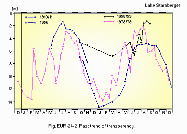
Past trend of transparency.
F. BIOLOGICAL FEATURES
F1 FLORA (1)- Emerged macrophytes
Phragmites australis, Scirpus lacustris, Phalaris arundinacea, Iris pseudacorus. - Submerged macrophytes
Chara contraris, C. fragilis, C. aspera, Nitellopsis obtusa, Potamogeton perfoliatus, P. pectinatus, Zanichellia palustris, Myriophyllum spicatum, Elodea canadensis, Ranunculus circinatus. - Phytoplankton
Aphanizomenon flos-aquae, Microcystis aeruginosa, Ceratium hirundinella, Dinobryon bararicum Melosira islandica spp. helvitica, Stephanodiscus astraea, Synedra acus, Chlamydomonas sp., Cosmarium depressum, Scenedesmus acutus f. costulatus.
- Zooplankton (1)
Mixodiaptomus laciniatus, Eudiaptomus gracilis, Cyclops vicinus, C. abyssorum, Mesocyclops leuckarti, Daphnia hyalina, D. galeata, Bosmina sp., Bythotrephes longimanus, Leptodora kindti. - Benthos (4)
Procladius pectinatus, Prodiamesa olivacea, Nanocladius balticus, Paracladius alpicola, Prectrocladius sordidellus, Cryptochironomus obreptans, Dicrotendipes pulsus, Parachironomus sp., Polypedilum pullum Micropsectra coracina. - Fish (5)
Coregonus sp., Salvilinus alpinus*, Perca fluviatilis*, Esox lucius*, Anguilla anguilla*, Abramis brama*, Blicca bjoerkna*, Rutilus rutilus*. * Economically important.
| Seeburg, 1978-1979 | ||||||||||||
| Net production* | ||||||||||||
| Jan | Feb | Mar | Apr | May | Jun | Jul | Aug | Sep | Oct | Nov | Dec | Ann. |
|---|---|---|---|---|---|---|---|---|---|---|---|---|
| 28.3 | 27.3 | 119.9 | 38.0 | 103.4 | 111.0 | 106.5 | 125.0 | 86.0 | 68.6 | 42.9 | 32.2 | 889.1 |
| * 0-20 m. | ||||||||||||
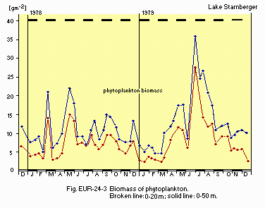
Biomass of phytoplankton. Broken line0-20 m; solid line: 0-50 m.
F5 FISHERY PRODUCTS (5)
- Annual fish catch [metric tons]
1981: 50-120.
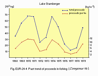
Past trend of proceeds in fishing (Coregonus sp.).
G. SOCIO-ECONOMIC CONDITIONS
G1 LAND USE IN THE CATCHMENT AREA (Q1, 6)| 1985 | ||
| Area [km2] | [%] | |
|---|---|---|
| - Natural landscape | ||
| Woody vegetation | 94.68 | 36.4 |
| Herbaceous vegetation | 0.03 | 0.0 |
| Swamp | 9.82 | 3.8 |
| Water surface | 6.73 | 2.6 |
| - Agricultural land | ||
| Crop field | 39.76 | 15.3 |
| Pasture land | 80.54 | 31.0 |
| - Residential area | 23.23 | 8.9 |
| - Others | 5.20 | 2.0 |
| - Total | 259.99 | 100.0 |
- Main types of woody vegetation (7)
Natural forest: deciduous forest (Fagus sylvatica, Quercus robur, Carpinus betulus). Secondary forest: evergreen conifer forest (Picea sp., Pinus sp.), deciduous forest (Fagus sp., Quercus sp., Carpinus sp.). - Types of the other important vegetation (7)
Swamp (Sphagnum sp., Pinus mugo, Carex duvaliana, Molinia coerulea, Eriophorum angustifolium, E. vaginatum, Drosera rotundifolia, Vaccinium oxycoccus, Orchidaceae). - Main kinds of crops: Wheat, maize, potato, barley, hop, beans (8).
- Levels of fertilizer application on crop fields: Heavy (9).
- Trends of change in land use (9)
Increase of maize fields (Zea mays). Increase in the utilization of greenland; change to crop fields. Increase of tourism and settlement area.
| 1987 | ||||
| Gross product during the year* [mill. DM] | No. of persons engaged | No. of establishments | ||
|---|---|---|---|---|
| Primary industry | 33.4 | 250 | 1,098 | |
| Secondary industry | 626.0 | 10,215 | 148 | |
| Tertiary industry | 625.4 | 5,672 | - | |
| * 1984. | ||||
- Numbers of domestic animals in the catchment area (16)
Cattle 23,840, horses 630, goat 35*, sheep 680, swine 3,230, poultry 38,230 (in 1982, *1977).
| 1980,1981 | |||
| Population | Population density [km-2] | Major cities (population) | |
|---|---|---|---|
| Total | 32,000 | 124 | Starnberg (17,050) |
H. LAKE UTILIZATION (Q1, Q2)
H1 LAKE UTILIZATION-
Sight-seeing and tourism (no. of visitors in 1986: >1,000,000), recreation
(swimming, sport-fishing, yachting) and fisheries.
I. DETERIORATION OF LAKE ENVIRONMENTS AND HAZARDS
I1 ENHANCED SILTATION (Q2)- Extent of damage: None.
- Present status: None.
- Nitrogen and phosphorus loadings to the lake [t yr-1](Q1, Q2)
| 1978-1979 | |||||
| Sources | Domestic | Agricultural | Natural | Others | Total |
|---|---|---|---|---|---|
| T-P | 7.0* | 6.7 | 6.3 | 1.0 | 21.0 |
| *1987: <3. | |||||
- Supplementary notes (Q1, Q2)
In the seventies a circular sewer line around the lake (50 km) was installed. The sewage of more than 85% of the population is diverted from the lake and treated in a plant placed at the lake's outlet. This led to an improvement in the trophic situation, now mesotrophic with a tendency to oligotrophic.
- Extent of damage: None.
J. WASTEWATER TREATMENTS
J1 GENERATION OF POLLUTANTS IN THE CATCHMENT AREA (Q2)-
c) Limited pollution with wastewater treatment.
f) Settlements (with total 54,000 inhabitants) are connected with a sewage diversion system in operation (50 km); now the lake is completely free from sewage load.
| [%] | |
|---|---|
| - Non-point sources | |
| Natural and dispersed settlements 40 | |
| Agricultural | 40 |
| - Point sources | 20 |
| - Total | 100 |
- Percentage of municipal population in the catchment area provided with
adequate sanitary facilities (on-site treatment systems) or public sewerage: 85% (Q1). - Percentage of rural population with adequate sanitary facilities (on-site
treatment systems): 12% - Municipal wastewater treatment systems: 1* (Q2).
* Not in the catchment area but at the lake outlet.
K. IMPROVEMENT WORKS IN THE LAKE (Q2)
K1 RESTORATION-
Sewage diversion by circular sewer line around the lake.
L. DEVELOPMENT PLANS (Q2)
-
Municipal sewerage shall be completed to cover finally 97% of the existing
population.
All new developments (e.g. settlements, hotels, industries) must be connected
to the public sewer system from the very beginning.
M. LEGISLATIVE AND INSTITUTIONAL MEASURES FOR UPGRADING LAKE ENVIRONMENTS
M1 NATIONAL AND LOCAL LAWS CONCERNED (Q1, Q2)- Names of the laws
- General German Water Act (no specific laws regarding to lakes)
- Water Act of Bavaria (Bayerisches Wasser-Gesetz)
- Country Development Program (Landesentwicklungsprogramm)
- Regional Plans
- Responsible authorities
- Bavarian State Department of Water Management, Munich
- Department of Water Management, Munich
- Organization for the sewage diversion and treatment project: "Zweckverband zur gemeinsamen Abwasserbeseitigung in den Gemeinden rund um den Starnberger See"
- Bavarian State Department for Water Management
- Department for Water Management, Munich
-
l) Bavarian State Department for Water Management
- Bavarian Institute for Fisheries, Starnberg
- Bavarian Health Department
N. SOURCES OF DATA
- Questionnaire filled by Dr. Christian Steinberg in cooperation with Christina Schirmer and Stefan Saumweber (Bayer. Landesamt fur Wasserwirtschaft, based on unpublished data of Bayerisches Landesamt fur Wasserwirtschaft, Munchen.
- Questionnaire filled by Klaus Bucksteeg, Bayerisches Landesamt fur Wasserwirtschaft, Munchen.
- Lenhart, B. & Steinberg, C. (1982) Zur Limnologie des Starnberger Sees. Informationsberichte 3/82, Bayerisches Landesamt fur Wasserwirtschaft, Munchen.
- Grimminger, H. Verzeichnis der Seen in Bayern. Teil 1: Text; Teil 2: Karten. Bayerisches Landesamt fur Wasserwirtschaft, Stand Marz 1987.
- Deutscher Wetterdienst, Wetteramt Munchen.
- Gerstmeier, R. (1985) Die quantitative Erfassung der profundalen Benthosfauna des Starnberger Sees, unter besonderer Berucksichtigung der Chironomiden (Diptera). Dissertation Fakultat Biologie an der Ludwig- Maximillian-Universitat, Munchen.
- Klein, M. (1988) Bayerische Landesanstalt fur Fisherei: Personal communication.
- Bayerisches Landesamt fur Statistik und Datenverarbeitung (1986) Die Bodenflachen Bayerns nach Nutzungsarten; Ergebnisse der Flachenerhebung 1985. Statistische Berichte, Munchen.
- Kaule, G., Schaller, J. & Schober, H.-M. (1978) Auswertung der Kartierung schutzwurdiger Biotope in Bayern. Schutzwurdige Biotope in Bayern, Heft 1. Bayerisches Landesamt fur Umweltschutz, Munchen.
- Bayerisches Landesamt fur Statistik und Datenverarbeitung (1984) Die Bodennutzung in Bayern 1983. Statistische Berichte, Munchen.
- Bucksteeg, K. (1984) Reinhaltung des Starnberger Sees. Bayerisches Landesamt fur Wasserwirtschaft, Munchen.
- Bayerisches Landesamt fur Statistik und Datenverarbeitung (1987) Bruttoinlandsprodukt und Bruttowertschopfung. Stat. Berichte, Munchen.
- Bayerisches Landesamt fur Statistik und Datenverarbeitung (1988) Sozialversicherungspflichtig beschaftigte Arbeitnermer in Bayern. Stat. Berichte, Munchen.
- Bayerisches Landesamt fur Statistik und Datenverarbeitung (1987) Bergbau und verarbeitendes Gewerbe in Bayern. Stat. Berichte, Munchen.
- Bayerisches Landesamt fur Statistik und Datenverarbeitung (1987) Bauhauptgewerbe in Bayern. Stat. Berichte, Munchen.
- Bayerisches Landesamt fur Statistik und Datenverarbeitung (1987) Ausbaugewerbe in Bayern. Stat. Berichte, Munchen.
- Bayerisches Landesamt fur Statistik und Datenverarbeitung (1987) Grossenstruktur der land-und forstwirtschaftlichen Betriebe in Bayern. Stat. Berichte, Munchen.
- Bayerisches Landesamt fur Statistik und Datenverarbeitung (1980) Die Viehbestande in Bayern am 2. Dezember 1977. Bayerisches Landesamt fur Statistik und Datenverarbeitung (1983) Die Viehbestande in Bayern am 3. Dezember 1982. Stat. Berichte, Munchen.
