
LAKE AMMERSEE
An evening view at a pier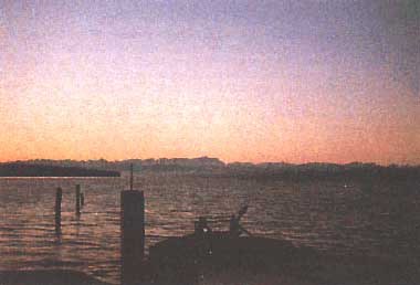
Photo: B. Lenhart
A. LOCATION
- Bayern, West Germany.*
- 47:54-48:02N, 11:05-11:10E; 533 m above sea level.
* Place names are not updated.
B. DESCRIPTION
-
Lake Ammersee is located 35 km north to the northern periphery of the Alps and was formed during the last glacial period ("Isar-Loisach-glacier") some 15,000-20,000 years ago. With a maximum depth of 81 m and a volume of 1.8 billion m3 Lake Ammersee is the third largest lake of Bavaria. The lake measures 15 km from north to south and reaches a maximum width of 5.5 km. The catchment area is 21.3 times as large as the lake itself. The main inflowing River Ammer (representing 72% of the catchment area) originates in the Alps ("Ammergauer Alpen"). The rates of loading are comparatively high. The water residence time is 2.7 years. Thirty-two% of the catchment area consist of woody vegetation-half is afforested plantation of conifers (Picea, Pinus) and half is mixed deciduous forest consisting mostly of beech (Fagus silvatica). Additional 56% are farmlands (69% pasture land, 31% crop field).
Surrounding settlements are mostly rural. As Munich, the capital of Bavaria with a population of 1.5 million, and Augsburg with a population of 440,000 inhabitants are situated nearby (25 km), the area is frequented for recreation activities.
The lake has been influenced by economic development since the 1950's by nutrient loading (municipal sewage). The rate of eutrophication slightly slowed down by installing a circular sewer line system in 1971 in addition to a treatment plant at the lake outlet. An improvement in the lake's trophic situation from eutrophic to now mesotrophic within the last years has taken place due to the completion of six treatment plants with chemical treatment (phosphorus removal) in the catchment area of River Ammer (built in the years 1981 and 1987) and to the regulation of total phosphorus concentration in German detergents since 1980 (Q1, Q2).
C. PHYSICAL DIMENSIONS (1, 2)
| Surface area [km2] | 47 |
| Volume [km3] | 1.774 |
| Maximum depth [m] | 82.5 |
| Mean depth [m] | 38.1 |
| Water level | Unregulated |
| Normal range of annual water level fluctuation [m] | 0.5-0.9 |
| Length of shoreline [km] | 43 |
| Residence time [yr] | 2.7 |
| Catchment area [km2] | 993 |
D. PHYSIOGRAPHIC FEATURES
D1 GEOGRAPHICAL- Bathymetric map: Fig. EUR-23-01.
- Number of outflowing rivers and channels (name): 1 (Ammer R.)(1).
- Climatic data near the lake, 1951-1980 (4)
| Mean temp. [deg C]*1 | ||||||||||||
| Jan | Feb | Mar | Apr | May | Jun | Jul | Aug | Sep | Oct | Nov | Dec | Ann. |
|---|---|---|---|---|---|---|---|---|---|---|---|---|
| -2.1 | -1.0 | 3.2 | 7.6 | 11.9 | 15.2 | 17.0 | 16.4 | 13.2 | 7.8 | 2.9 | -0.7 | 7.6 |
| Precipitation [mm]*2 | ||||||||||||
| 52 | 52 | 51 | 73 | 102 | 140 | 127 | 114 | 79 | 58 | 58 | 46 | 952 |
| *1 Station Ottilien. *2 Seefeld. | ||||||||||||
- Number of hours of bright sunshine: ca. 840 hr yr-1 (Q1).
- Solar radiation (Hohenpei enberg, 1978-1979): 11.1 MJ m-2 day-1 (Q1).
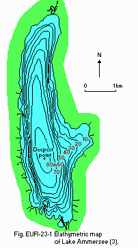
Bathymetric map (3).
- Water temperature [deg C](Q1)
| Deepest point, 1985-1986 | ||||||||||||
| Depth [m] | Jan* | Feb* | Mar | Apr | May | Jun | Jul | Aug | Sep | Oct | Nov | Dec |
|---|---|---|---|---|---|---|---|---|---|---|---|---|
| 0 | 3.9 | 3.2 | - | 4.7 | 13.2 | 16.3 | 19.4 | 21.0 | 16.8 | 14.1 | 8.0 | 5.7 |
| 2 | 3.9 | 3.2 | - | 5.0 | 11.6 | 16.0 | 19.1 | 20.6 | 16.7 | 14.1 | 8.0 | 5.7 |
| 4 | 3.9 | 3.2 | - | 4.9 | 10.6 | 15.1 | 18.4 | 19.4 | 16.4 | 14.1 | 8.0 | 5.7 |
| 6 | 3.9 | 3.2 | - | 4.3 | 7.8 | 12.8 | 16.2 | 18.2 | 16.0 | 13.8 | 8.0 | 5.7 |
| 8 | 3.9 | 3.2 | - | 4.7 | 7.4 | 11.9 | 13.1 | 16.0 | 15.6 | 13.5 | 8.0 | 5.7 |
| 10 | 3.9 | 3.2 | - | 4.6 | 6.4 | 9.3 | 10.8 | 13.1 | 12.2 | 12.8 | 8.0 | 5.7 |
| 13 | 3.9 | 3.2 | - | 4.6 | 5.9 | 7.2 | 8.2 | 11.0 | 9.0 | 11.1 | 8.0 | 5.7 |
| 16 | 3.9 | 3.2 | - | 4.6 | 5.7 | 6.2 | 7.1 | 7.7 | 7.4 | 8.1 | 7.6 | 5.3 |
| 20 | 3.9 | 3.2 | - | 4.6 | 5.8 | 5.6 | 6.1 | 6.4 | 6.2 | 6.6 | 7.4 | 5.1 |
| 30 | 3.9 | 3.3 | - | 4.3 | 5.5 | 5.0 | 5.1 | 5.2 | 5.3 | 5.2 | 5.4 | 5.0 |
| 40 | 4.0 | 3.4 | - | 4.3 | 5.1 | 4.8 | 4.8 | 5.0 | 4.9 | 4.8 | 5.1 | 4.9 |
| 50 | 4.0 | 3.4 | - | 4.3 | 4.9 | 4.7 | 4.6 | 4.8 | 4.8 | 4.7 | 4.8 | 4.8 |
| 60 | 4.0 | 3.6 | - | 4.3 | 4.8 | 4.6 | 4.6 | 4.7 | 4.6 | 4.6 | 4.7 | 4.7 |
| 70 | 4.0 | 3.7 | - | 4.4 | 4.7 | 4.5 | 4.5 | 4.5 | 4.5 | 4.5 | 4.6 | 4.6 |
| 80 | - | 3.7 | - | 4.2 | 4.5 | 4.6 | 4.4 | 4.4 | 4.4 | 4.4 | 4.5 | 4.6 |
| * Only for 1986. | ||||||||||||
- Freezing period: January-March (1).
- Mixing type: Dimictic (1).
E. LAKE WATER QUALITY (Q1)
E1 TRANSPARENCY [m]| Deepest point, 1985-1986 | ||||||||||||
| Depth [m] | Jan | Feb | Mar | Apr | May | Jun | Jul | Aug | Sep | Oct | Nov | Dec |
|---|---|---|---|---|---|---|---|---|---|---|---|---|
| 6.0 | 6.6 | - | 4.4 | 1.6 | 1.9 | 3.1 | 2.4 | 4.7 | 4.5 | 6.9 | 7.4 | |
| Deepest point, 1985-1986 | |||||||||||||
| Depth [m] | Jan* | Feb* | Mar | Apr | May | Jun | Jul | Aug | Sep | Oct | Nov | Dec | |
|---|---|---|---|---|---|---|---|---|---|---|---|---|---|
| 0 | 8.3 | 8.3 | - | 8.4 | 8.6 | 8.6 | 8.6 | 8.5 | 8.4 | 8.4 | 8.3 | 8.2 | |
| 2 | 8.3 | 8.3 | - | 8.3 | 8.6 | 8.6 | 8.6 | 8.6 | 8.4 | 8.4 | 8.3 | 8.2 | |
| 4 | 8.3 | 8.3 | - | 8.4 | 8.5 | 8.5 | 8.6 | 8.5 | 8.4 | 8.4 | 8.3 | 8.2 | |
| 6 | 8.3 | 8.3 | - | 8.2 | 8.3 | 8.4 | 8.4 | 8.4 | 8.3 | 8.4 | 8.3 | 8.3 | |
| 8 | 8.3 | 8.3 | - | 8.3 | 8.3 | 8.3 | 8.2 | 8.2 | 8.3 | 8.3 | 8.3 | 8.3 | |
| 10 | 8.3 | 8.2 | - | 8.3 | 8.3 | 8.2 | 8.0 | 8.0 | 7.9 | 8.3 | 8.3 | 8.3 | |
| 13 | 8.3 | 8.2 | - | 8.3 | 8.2 | 8.2 | 7.9 | 8.0 | 7.8 | 8.1 | 8.3 | 8.4 | |
| 16 | 8.2 | 8.2 | - | 8.3 | 8.2 | 8.1 | 7.9 | 7.8 | 7.8 | 7.8 | 8.2 | 8.3 | |
| 20 | 8.2 | 8.2 | - | 8.3 | 8.2 | 8.2 | 8.0 | 7.9 | 7.9 | 7.8 | 8.2 | 8.3 | |
| 30 | 8.2 | 8.2 | - | 8.3 | 8.2 | 8.2 | 8.0 | 7.9 | 7.9 | 7.9 | 8.0 | 8.5 | |
| 40 | 8.2 | 8.1 | - | 8.3 | 8.2 | 8.2 | 8.0 | 8.0 | 7.9 | 8.0 | 8.0 | 8.4 | |
| 50 | 8.2 | 8.1 | - | 8.3 | 8.3 | 8.2 | 8.0 | 8.0 | 8.0 | 8.0 | 8.0 | 8.3 | |
| 60 | 8.2 | 8.1 | - | 8.3 | 8.2 | 8.1 | 8.0 | 8.0 | 7.9 | 7.9 | 7.9 | 8.2 | |
| 70 | 8.2 | 8.1 | - | 8.3 | 8.2 | 8.1 | 7.9 | 7.8 | 7.9 | 7.8 | 7.8 | 8.0 | |
| 80 | 8.2 | 8.0 | - | 8.3 | 8.1 | 8.0 | 7.8 | 7.7 | 7.6 | 7.6 | 7.7 | 7.8 | |
| * Only for 1986. | |||||||||||||
| Deepest point, 1985-1986 | ||||||||||||
| Depth [m] | Jan* | Feb* | Mar | Apr | May | Jun | Jul | Aug | Sep | Oct | Nov | Dec |
|---|---|---|---|---|---|---|---|---|---|---|---|---|
| 0 | 11.2 | 11.6 | - | 12.0 | 13.8 | 10.8 | 10.0 | 9.7 | 9.6 | 10.1 | 9.5 | 10.0 |
| 2 | 11.1 | 11.6 | - | 12.0 | 13.9 | 11.0 | 10.1 | 9.7 | 9.7 | 9.8 | 9.6 | 10.1 |
| 4 | 11.1 | 11.6 | - | 12.0 | 12.4 | 10.8 | 9.7 | 9.4 | 9.5 | 10.0 | 9.5 | 10.1 |
| 6 | 11.1 | 11.6 | - | 11.8 | 11.5 | 9.5 | 8.8 | 8.2 | 8.8 | 9.0 | 9.6 | 10.1 |
| 8 | 11.1 | 11.6 | - | 11.8 | 11.2 | 9.3 | 7.4 | 6.7 | 7.3 | 8.4 | 9.5 | 10.0 |
| 10 | 11.1 | 11.5 | - | 11.8 | 11.0 | 9.2 | 6.4 | 5.7 | 4.5 | 7.6 | 9.5 | 10.0 |
| 13 | 11.1 | 11.5 | - | 11.7 | 10.7 | 9.2 | 7.2 | 6.0 | 5.2 | 5.3 | 9.5 | 10.0 |
| 16 | 11.1 | 11.5 | - | 11.8 | 10.9 | 9.5 | 7.9 | 6.8 | 6.2 | 5.4 | 8.5 | 8.8 |
| 20 | 11.0 | 11.5 | - | 11.7 | 11.1 | 10.1 | 8.6 | 8.0 | 7.5 | 6.4 | 8.6 | 9.2 |
| 30 | 11.0 | 11.5 | - | 11.8 | 11.2 | 10.6 | 10.1 | 8.9 | 9.1 | 8.8 | 8.8 | 9.8 |
| 40 | 11.0 | 11.4 | - | 11.6 | 11.1 | 10.7 | 10.4 | 9.8 | 9.2 | 9.3 | 9.1 | 9.0 |
| 50 | 11.0 | 11.4 | - | 11.9 | 11.1 | 10.8 | 10.3 | 10.1 | 9.2 | 9.5 | 9.0 | 8.2 |
| 60 | 11.1 | 11.2 | - | 11.6 | 11.0 | 10.4 | 9.9 | 9.5 | 8.8 | 8.9 | 7.6 | 6.4 |
| 70 | 11.1 | 11.0 | - | 11.6 | 10.8 | 10.0 | 8.8 | 7.4 | 6.1 | 6.1 | 4.5 | 2.8 |
| 80 | 11.0 | 10.8 | - | 11.4 | 10.3 | 7.7 | 6.2 | 3.9 | 2.3 | 2.1 | 1.0 | 1.5 |
| * Only for 1986. | ||||||||||||
| Deepest point, 1985-1986 | ||||||||||||
| Depth [m] | Jan* | Feb* | Mar | Apr | May | Jun | Jul | Aug | Sep | Oct | Nov | Dec |
|---|---|---|---|---|---|---|---|---|---|---|---|---|
| 0 | 1.5 | 2.1 | - | 8.9 | 22.9 | 10.5 | 6.3 | 7.3 | 8.6 | 4.6 | 3.2 | 4.5 |
| 2 | 0.9 | 2.2 | - | 9.0 | 31.9 | 10.7 | 7.6 | 5.7 | 10.2 | 7.4 | 3.5 | 4.6 |
| 4 | 1.3 | 2.1 | - | 8.6 | 19.0 | 11.1 | 6.7 | 5.7 | 9.0 | 7.1 | 3.9 | 4.1 |
| 6 | 0.9 | 4.1 | - | 4.6 | 14.3 | 13.0 | 5.7 | 6.1 | 7.1 | 5.9 | 4.0 | 7.0 |
| 8 | 0.9 | 2.8 | - | 6.2 | 11.9 | 7.7 | 6.0 | 7.2 | 5.9 | 5.7 | 3.9 | 3.7 |
| 10 | 0.9 | 1.9 | - | 4.8 | 7.9 | 4.6 | 4.5 | 6.1 | 4.0 | 4.3 | 3.8 | 3.8 |
| 13 | 0.9 | 0.7 | - | 4.4 | 8.6 | 3.7 | 2.8 | 4.7 | 2.2 | 2.6 | 3.5 | 1.3 |
| 16 | 1.5 | 3.0 | - | 4.1 | 6.1 | 2.9 | 2.3 | 4.7 | 1.6 | 1.8 | 2.8 | 1.4 |
| 20 | 0.8 | 2.2 | - | 4.3 | 5.7 | 2.6 | 1.9 | 4.7 | 1.4 | 1.3 | 1.4 | 1.7 |
| 30 | 1.1 | 1.5 | - | 4.3 | 4.3 | 1.7 | 1.4 | 3.7 | 1.6 | 1.0 | 0.8 | 1.3 |
| 40 | 1.7 | 1.9 | - | 4.0 | 4.0 | 1.5 | 1.1 | 4.0 | 0.7 | 0.7 | 0.8 | 0.0 |
| 50 | 2.1 | 1.5 | - | 3.4 | 3.8 | 1.6 | 1.1 | 4.2 | 0.7 | 0.7 | 0.5 | 0.0 |
| 60 | 1.1 | 1.3 | - | 4.0 | 3.9 | 1.6 | 1.3 | 4.0 | 1.2 | 0.6 | 0.5 | 0.7 |
| 70 | 1.1 | 1.1 | - | 3.2 | 3.2 | 1.7 | 0.9 | 4.2 | 0.8 | 0.6 | 0.5 | 0.0 |
| 80 | 0.8 | 0.9 | - | 2.5 | 1.7 | 2.2 | 1.1 | 3.4 | 0.6 | 0.5 | 0.4 | 0.4 |
| * Only for 1986. | ||||||||||||
- NO3-N [mg l-1]
| Deepest point, 1985-1986 | ||||||||||||
| Depth [m] | Jan* | Feb* | Mar | Apr | May | Jun | Jul | Aug | Sep | Oct | Nov | Dec |
|---|---|---|---|---|---|---|---|---|---|---|---|---|
| 0 | 1.10 | 1.07 | - | 1.00 | 0.79 | 0.73 | 0.79 | 0.77 | 0.76 | 0.85 | 0.99 | 1.03 |
| 2 | 0.06 | 1.07 | - | 1.00 | 0.81 | 0.71 | 0.78 | 0.78 | 0.79 | 0.86 | 0.98 | 1.03 |
| 4 | 1.03 | 1.07 | - | 1.00 | 0.88 | 0.72 | 0.80 | 0.80 | 0.79 | 0.86 | 0.98 | 1.04 |
| 6 | 1.01 | 1.07 | - | 1.00 | 0.97 | 0.79 | 0.85 | 0.82 | 0.82 | 0.88 | 0.98 | 1.04 |
| 8 | 1.03 | 1.07 | - | 1.00 | 1.00 | 0.86 | 0.94 | 0.89 | 0.81 | 0.91 | 0.99 | 1.03 |
| 10 | 1.03 | 1.07 | - | 1.00 | 1.02 | 0.92 | 1.02 | 0.96 | 0.97 | 0.94 | 0.97 | 1.04 |
| 13 | 1.03 | 1.07 | - | 1.01 | 1.04 | 0.99 | 1.12 | 1.00 | 1.04 | 1.05 | 0.98 | 1.04 |
| 16 | 1.01 | 1.07 | - | 1.01 | 1.05 | 1.03 | 1.14 | 1.07 | 1.03 | 1.11 | 1.02 | 1.07 |
| 20 | 1.01 | 1.08 | - | 1.01 | 1.05 | 1.04 | 1.13 | 1.07 | 1.04 | 1.11 | 1.03 | 1.08 |
| 30 | 1.04 | 1.08 | - | 1.01 | 1.06 | 1.05 | 1.13 | 1.09 | 1.05 | 1.12 | 1.08 | 1.08 |
| 40 | 1.01 | 1.08 | - | 1.01 | 1.06 | 1.05 | 1.10 | 1.06 | 1.02 | 1.11 | 1.09 | 1.07 |
| 50 | 1.01 | 1.08 | - | 1.01 | 1.06 | 1.03 | 1.12 | 1.05 | 1.03 | 1.09 | 1.09 | 1.08 |
| 60 | 1.01 | 1.06 | - | 1.02 | 1.06 | 1.03 | 1.11 | 1.05 | 1.01 | 1.07 | 1.06 | 1.05 |
| 70 | 1.01 | 1.05 | - | 1.01 | 1.05 | 1.03 | 1.09 | 1.04 | 0.98 | 1.05 | 0.99 | 0.93 |
| 80 | 1.05 | 1.08 | - | 1.00 | 1.05 | 0.99 | 1.10 | 0.99 | 0.91 | 0.97 | 0.87 | 0.87 |
| * Only for 1986. | ||||||||||||
| Deepest point, 1985-1986 | ||||||||||||
| Depth [m] | Jan* | Feb* | Mar | Apr | May | Jun | Jul | Aug | Sep | Oct | Nov | Dec |
|---|---|---|---|---|---|---|---|---|---|---|---|---|
| 0 | 10 | 7 | - | 19 | 23 | 22 | 42 | 18 | 25 | 31 | 20 | 12 |
| 2 | 10 | 7 | - | 19 | 31 | 20 | 38 | 14 | 22 | 23 | 20 | 12 |
| 4 | 6 | 7 | - | 16 | 51 | 25 | 41 | 13 | 25 | 19 | 22 | 11 |
| 6 | 6 | 7 | - | 20 | 41 | 44 | 39 | 22 | 27 | 21 | 19 | 11 |
| 8 | 6 | 7 | - | 14 | 32 | 27 | 37 | 14 | 30 | 23 | 20 | 10 |
| 10 | 6 | 7 | - | 14 | 25 | 27 | 24 | 13 | 15 | 15 | 19 | 10 |
| 13 | 6 | 7 | - | 14 | 14 | 16 | 13 | 9 | 12 | 12 | 20 | 11 |
| 16 | 8 | 7 | - | 15 | 14 | 11 | 12 | 7 | 10 | 9 | 18 | 10 |
| 20 | 6 | 7 | - | 14 | 14 | 8 | 11 | 9 | 9 | 8 | 16 | 12 |
| 30 | 6 | 7 | - | 13 | 14 | 7 | 7 | 8 | 9 | 8 | 15 | 8 |
| 40 | 5 | 7 | - | 14 | 15 | 8 | 7 | 7 | 6 | 8 | 15 | 8 |
| 50 | 5 | 7 | - | 14 | 14 | 6 | 7 | 7 | 10 | 9 | 15 | 8 |
| 60 | 5 | 7 | - | 12 | 14 | 9 | 7 | 6 | 13 | 8 | 14 | 9 |
| 70 | 5 | 7 | - | 14 | 14 | 10 | 6 | 5 | 13 | 8 | 18 | 9 |
| 80 | 5 | 10 | - | 14 | 12 | 26 | 6 | 9 | 15 | 9 | 30 | 6 |
| * Only for 1986. | ||||||||||||
- Total-P [micro g l-1]
| Deepest point, 1985-1986 | ||||||||||||
| Depth [m] | Jan* | Feb* | Mar | Apr | May | Jun | Jul | Aug | Sep | Oct | Nov | Dec |
|---|---|---|---|---|---|---|---|---|---|---|---|---|
| 0 | 32 | 29 | - | 41 | 39 | 27 | 20 | 18 | 17 | 14 | 14 | 15 |
| 2 | 30 | 29 | - | 46 | 54 | 35 | 28 | 17 | 24 | 14 | 16 | 15 |
| 4 | 29 | 30 | - | 38 | 45 | 30 | 28 | 16 | 20 | 13 | 14 | 16 |
| 6 | 30 | 30 | - | 31 | 35 | 32 | 23 | 11 | 17 | 13 | 13 | 15 |
| 8 | 38 | 28 | - | 37 | 25 | 25 | 22 | 12 | 19 | 13 | 14 | 14 |
| 10 | 25 | 29 | - | 33 | 23 | 24 | 20 | 12 | 15 | 12 | 14 | 16 |
| 13 | 27 | 28 | - | 32 | 21 | 19 | 17 | 20 | 15 | 11 | 14 | 16 |
| 16 | 28 | 31 | - | 35 | 19 | 17 | 15 | 9 | 15 | 11 | 13 | 15 |
| 20 | 29 | 31 | - | 34 | 22 | 17 | 16 | 9 | 16 | 11 | 12 | 15 |
| 30 | 28 | 28 | - | 34 | 21 | 18 | 27 | 18 | 27 | 19 | 16 | 16 |
| 40 | 28 | 29 | - | 32 | 25 | 24 | 28 | 24 | 34 | 25 | 22 | 27 |
| 50 | 30 | 31 | - | 30 | 26 | 26 | 29 | 25 | 35 | 30 | 33 | 33 |
| 60 | 29 | 32 | - | 31 | 26 | 28 | 30 | 27 | 36 | 31 | 41 | 41 |
| 70 | 29 | 31 | - | 30 | 26 | 27 | 36 | 36 | 46 | 44 | 61 | 77 |
| 80 | 28 | 33 | - | 32 | 27 | 32 | 44 | 60 | 83 | 82 | 107 | 80 |
| * Only for 1986. | ||||||||||||
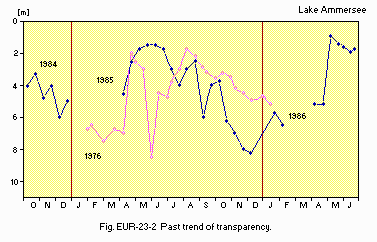
Past trend of transparency.
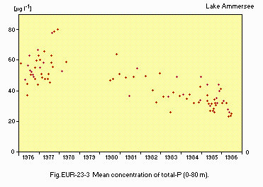
Mean concentration of total-P (0-80 m).
F. BIOLOGICAL FEATURES
F1 FLORA- Emerged macrophytes (5)
Acorus calamus, Eleocharis acicularis, Equisetum palustre, Iris pseudacorus, Juncus articulatus, Phragmites communis, Polygonum amphibium, Scirpus lacustris, Sium erectum, Typha latifolia. - Floating macrophytes: Lemna minor (5).
- Submerged macrophytes (5)
Chara aspera, C. intermedia, Elodea canadensis, Myriophyllum spicatum, Potamogeton berchtoldii, P. lucens, P. pectinatus, Ranunculus circinatus, Stratiotes aloides, Zannichellia palustris. - Phytoplankton (1)
Anabaena flos-aquae, Microcystis aeruginosa, Ceratium hirundinella, Dinobryon crenulatum, Melosira islandica, Stephanodiscus parvus, Chlamydomonas sp., Scenedesmus acutus, Closterium acutum.
- Zooplankton (Q1)
Rotatoria (Conochilus unicornis, Keratella cochlearis, Kellicottia longispina, Branchionus angularis, Trichocerca capucina, Synchaeta oblonga), Phyllopoda (Daphnia hyalina, Leptodora kindtii), Copepoda (Cyclops strenuus), Ciliata (Tintinnopsis lacustris). - Benthos (6)
0-20 m Valvata piscinalis, Pisoidium sp., Uniopictorum sp., Dendrocoelum lacteum, Helobdella stagnalis, H. octoculata, Pelosolex ferox, Limnodrilus sp., Tubifex sp., Sialis sp., Trichopterae sp., Chironomidae, Ephemera danica, Ceratopogon sp. - Fish (7)
Salvelinus alpinus*, Perca fluviatilis*, Esox lucius*, Stizostedion lucioperca*, Cyprinus carpio*, Tinca tinca*, Anguilla anguilla*, Abramis brama*, Blicca bjoerkna*, Rutilus rutilus*. * Economically important.
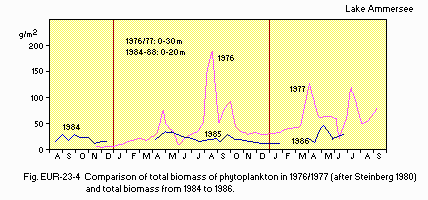
Comparison of total biomass of phytoplankton in 1976/1977 (after Steinberg 1980) and total biomass from 1984 to 1986.
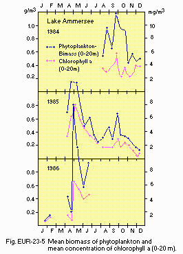
Mean biomass of phytoplankton and mean concentration of chlorophyll a (0-20 m).
F5 FISHERY PRODUCTS (7)
- Annual fish catch [metric tons]
1980-1987: 40-150.
G. SOCIO-ECONOMIC CONDITIONS
G1 LAND USE IN THE CATCHMENT AREA (Q1, 8, 9)| 1985 | ||
| Area [km2] | [%] | |
|---|---|---|
| - Natural landscape | ||
| Woody vegetation | 314.59 | 31.6 |
| Herbaceous vegetation | 0.14 | 0.0 |
| Swamp | 23.53 | 2.4 |
| Water surface | 25.58 | 2.6 |
| - Agricultural land | ||
| Crop field | 174.05 | 17.5 |
| Pasture land | 382.30 | 38.4 |
| - Residential area | 58.33 | 5.9 |
| - Others | 16.02 | 1.6 |
| - Total | 994.54 | 100.0 |
- Main types of woody vegetation (10)
Natural forest; deciduous forest (Fagus sylvatica, Quercus robur, Carpinus betulus). Secondary forest; evergreen conifer forest (Picea sp., Pinus sp.), deciduous forest (Fagus sp., Quercus sp., Carpinus sp.). - Types of the other important vegetation (10)
Swamp (Sphagnum sp., Pinus mugo, Carex duvaliana, Molinia coerulea, Eriophorum angutifolium, E. vaginatum, Drosera rotundifolia, Vaccinium oxycoccus, Orchidaceae). - Main kinds of crops (9)
Sugar-beet, wheat, maize, potato, barley, hop, beans. - Levels of fertilizer application on crop fields: Heavy (11).
| 1987 | |||
| Gross product during the year [mill. DM] | No. of persons engaged | No. of establishments | |
|---|---|---|---|
| Primary industry | 94.3 | 560 | 3,183 |
| Secondary industry | 1,250.2 | 21,681 | 324 |
| Tertiary industry | 1,523.3 | 14,249 | - |
- Numbers of domestic animals in the catchment area (18)
Cattle 64,990, horse 1,600, goat 115*, sheep 4,480, swine 8,040, poultry 100,615 (* in 1977).
| 1980,1981 | |||
| Population | Population density [km-2] | Major cities (population) | |
|---|---|---|---|
| Total | 108,000 | 108 | None |
H. LAKE UTILIZATION (Q2)
H1 LAKE UTILIZATION-
Sight-seeing and tourism (no. of visitors in 1986: >1,000,000), recreation
(swimming, sport-fishing, yachting) and fisheries.
I. DETERIORATION OF LAKE ENVIRONMENTS AND HAZARDS
I1 ENHANCED SILTATION (Q2)- Extent of damage: Not serious.
- Present status: None.
- Nitrogen and phosphorus loadings to the lake [t yr-1](11, 19)
| 1982-1984 | |||||
| Sources | Industrial | Domestic | Agricultural | Natural | Total |
|---|---|---|---|---|---|
| T-P | 0 | 37.5 | 0 | 18.5 | 56 |
- Supplementary notes (Q2)
In the seventies a circular sewer line around the lake was installed. The sewage of about 50% of the population of the catchment area is diverted from the lake and treated in a plant placed at the lake's outlet. About 20% of the population is served by mechanical-biological-chemical treatment plants. The lake recovered from eutrophic to mesotrophic within the last 3 years.
- Extent of damage: None.
J. WASTEWATER TREATMENTS
J1 GENERATION OF POLLUTANTS IN THE CATCHMENT AREA (Q1, Q2)-
d) Measurable pollution with limited wastewater treatment.
f) Settlements are connected to a sewerage diversion system. At the mouth, River Ammer (main loading) is provided with six treatment plants with chemical treatment (phosphorus removal).
| [%] | |
|---|---|
| - Non-point sources | |
| Natural and dispersed settlements | 30 |
| Agricultural | 35 |
| - Point sources | 35 |
| - Total | 100 |
- Percentage of municipal population in the catchment area provided with
adequate sanitary facilities (on-site treatment systems) or public sewerage: 71% (Q1). - Percentage of rural population with adequate sanitary facilities (on-site
treatment systems): 29% (Q1). - Municipal wastewater treatment systems
No. of tertiary treatment systems: 6 (Q2). No. of secondary treatment systems: 1* (Q2). * Not in the catchment area, but at the lake outlet.
K. IMPROVEMENT WORKS IN THE LAKE
K1 RESTORATION (Q2, 1)-
In 1971 a circular sewer line systems was installed; in 1981-1987 6 treatment plants with chemical treatment were built.
L. DEVELOPMENT PLANS (Q2)
-
Municipal sewerage shall be completed that finally cover 95% of the existing population. All new developments (e.g. settlements, hotels, industries) must be connected to public sewer systems from the very beginning.
M. LEGISLATIVE AND INSTITUTIONAL MEASURES FOR UPGRADING LAKE ENVIRONMENTS
M1 NATIONAL AND LOCAL LAWS CONCERNED (Q1, Q2)- Names of the lows (the year of legislation)
- General German Act (no specific laws regarding to lakes)
- Water Act of Bavaria (Bayerisches Wasser-Gesetz)
- Country Development Program (Landesentwicklungsprogramm)
- Regional Plans
- Responsible authorities
- Bavarian State Department for Water Management, Munich
- Department for Water Management, Landsberg am Lech
- Organizations for the sewage diversion and treatment project 1. "Zweckverband zur Abwasserbeseitigung Ammersee-Ost" (1963) 2. "Zweckverband zur Abwasserbeseitigung Ammersee-West" (1957)
- Bavarian State Department for Water Management, Munich
- Technical University of Munich
- Bavarian Institute for Fisheries, Starnberg
- Bavarian Health Department
- Department for Water Management, Weilheim
N. SOURCES OF DATA
- Questionnaire filled by Dr. Christian Steinberg in cooperation with Christina Schirmer and Stefan Saumweber (Bayer Landesamt fur Wasserwirtschaft, Munchen), based on unpublished data of Bayerisches Landesamt fur Wasserwirtschaft.
- Questionnaire filled by Klaus Bucksteeg, Bayerisches Landesamt fur Wasserwirtschaft, Munchen.
- Lenhart, B. (1987) Limnologische Studien am Ammersee 1984-1986. Informationsberichte Bayerisches Landesamt fur Wasserwirtschaft, Munchen.
- Bucksteeg, K. (1984) Reinhaltung des Starnberger Sees. Bayerisches Landesamt fur Wasserwirtschaft, Munchen.
- Grimminger, H. Verzeichnis der Seen in Bayern, Teil 1: Text; Teil 2: Karten. Bayerisches Landesamt fur Wasserwirtschaft, Munchen. Stand: Marz 1987.
- Deutscher Wetterdienst, Wetteramt Munchen.
- Melzer, A., Harlacher, R., Held, K. & Vogt, E. (1988, in press) Die Makrophytenvegetation des Ammer-, Worth-, Pilsen- und Wesslinger Sees. Informationsberichte Bayerisches Landesamt fur Wasserwirtschaft, Munchen.
- Reimann, K. (1955) Bericht uber die Untersuchungen des Ammersees im Jahre 1955. Unveroffentlichtes Gutachten der (damaligen) Bayerischen Bilologischen Versuchsanstalt, Munchen.
- Klein, M. (1988) Bayerische Landesanstalt fur Fisherei: Personal communication.
- Bayerisches Landesamt fur Statistik und Datenverarbeitung (1986) Die Bodenflachen Bayerns nach Nutzungsarten; Ergebnisse der Flachenerhebung 1985. Statistische Berichte, Munchen.
- Bayerisches Landesamt fur Statistik und Datenverarbeitung (1984) Die Bodennutzung in Bayern 1983. Statistische Berichte, Munchen.
- Kaule, G., Schaller, J. & Schober, H. M. (1978) Auswertung der Kartierung schutzwurdiger Biotope in Bayern. Schutzwurdige Biotope in Bayern, Heft 1. Bayerisches Landesamt fur Umweltschutz, Munchen.
- Hollfelder (1982) Ammerseestudie (unpublished manuscript).
- Bayerisches Landesamt fur Statistik und Datenverarbeitung (1987) Bruttoinlandsprodukt und Bruttowertschopfung. Stat. Berichte, Munchen.
- Bayerisches Landesamt fur Statistik und Datenverarbeitung (1988) Sozialversicherungspflichtig beschaftigte Arbeitnehmer in Bayern. Stat. Berichte, Munchen.
- Bayerisches Landesamt fur Statistik und Datenverarbeitung (1987) Bergbau und Verarbeitendes Gewerbe in Bayern. Stat. Berichte, Munchen.
- Bayerisches Landesamt fur Statistik und Datenverarbeitung (1987) Bauhauptgewerbe in Bayern. Stat. Berichte, Munchen.
- Bayerisches Landesamt fur Statistik und Datenverarbeitung (1987) Ausbaugewerbe in Bayern. Stat. Berichte, Munchen.
- Bayerisches Landesamt fur Statistik und Datenverarbeitung (1987) Grossenstruktur der Land-und Forstwirtschaftlichen Betriebe in Bayern. Stat. Berichte, Munchen.
- Bayerisches Landesamt fur Statistik und Datenverarbeitung (1980) Die Viehbestande in Bayern am 2. Dezember 1977. Stat. Berichte, Munchen.
- Bayerisches Landesamt fur Statistik und Datenverarbeitung (1983) Die Viehbestande in Bayern am 3. Dezember 1982. Stat. Berichte, Munchen.
- Lenhart, B. & Steinberg, C. (1986) Auswirkungen der phosphathochstmengenverordnung am Ammersee (Effects of phosphorus reduction in detergents on Lake Ammersee). Wasser, 67: 237-248.
