LOUGH DERG (LAKE DERG)
A view from the lakeside hill
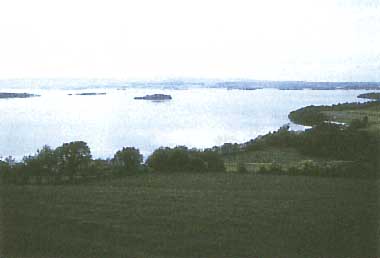
Photo: Irish Tourist Board
A. LOCATION
- Galway, Glare and Tipperary*, Ireland.
- 52:49-53:06N, 8¡¦9-8:31W; 33.5 m above sea level.
* North Riding.
B. DESCRIPTION
Lough Derg, the lower of the two larger lakes on the River Shannon, is located within the limit of the last glaciation and in an area of active ice-erosion. Evidence of its origin by ice erosion is seen through the irregularity of the lake floor and by the relationship of this irregularity to the various rocks (1). The southern portion of the lake was formed by ice being forced through a narrow valley between hills.
The lake lies at the southern limit of the central plain. It is bordered by Co. Glare on the south, by Co. Galway on the north and west and by Co. Tipperary (North Riding) on the east. It lies at 33.5 m above sea level and has a surface area of 117.50 km2. Lough Derg extends from Portumna in the north to Killaloe in the south with a maximum distance along its north-south axis of 35 km. Its maximum width is 14.5 km across the Scarriff-Youghal Bay transect, but the average width is less than 5 km.
The extreme northern portion of the lake, encompassing Portumna, Slevoir and Cloondavaun Bays, is relatively shallow with a mean depth of 4 m. The shores in this area are flat and there are extensive reed beds in the bays. An axial trench descending to 29 m occupies the central portion of the lake (1). The Scarriff to Youghal Bay section of the lake is uneven in depth, and a small trench fringing Parkers Point descends to 36 m. The long, narrow, southern reach of the lake extending to Killaloe, has the greatest water abstraction for domestic and other uses are presently made at Portumna at the northern end of the lake and from the lake outflow for the city of Limerick (pop. -70,000). A further abstraction is being developed for a rural water supply scheme for the Co. Tipperary (NR) area to the east of the lake.
Lough Derg is unique amongst Irish lakes in that it was the subject of biological research in the early years of this century. The reports of this work form a valuable background in comparison with the findings of recent surveys and indicate that a significant increase in the abundance of planktonic algae had occurred in the lake between 1922 and the period 1976- 1978 (4). Further increases in the levels of algal development have been noted in recent years giving rise to concern amongst angling and tourism interests along the lake shore and also at the water abstraction plant for Limerick City on the River Shannon downstream of the lake.
C. PHYSICAL DIMENSIONS (Q)
| Surface area [km2] | 118 |
| Volume [km3] | 0.887 |
| Maximum depth [m] | 36 |
| Mean depth [m] | 7.6 |
| Water level | Regulated |
| Normal range of annual water level fluctuation [m] | 0.3 |
| Length of shoreline [km] | 179 |
| Residence time [yr] | 0.2 |
| Catchment area [km2] | 10,280 |
D. PHYSIOGRAPHIC FEATURES (Q)
D1 GEOGRAPHICAL
- Bathymetric map: Fig. EUR-22-01.
- Names of main islands
Illaunmore (0.61 km2), Cameron (0.3 km2), Holy (0.2 km2) and Caher (0.07 km2).
- Number of outflowing rivers and channels (name): 1 (R. Shannon).
D2 CLIMATIC
- Climatic data at Birr, 1951-1980
| Mean temp. [deg C] |
| Jan | Feb | Mar | Apr | May | Jun | Jul | Aug | Sep | Oct | Nov | Dec | Ann. |
|---|
| 4.4 | 4.6 | 6.3 | 8.1 | 10.7 | 13.4 | 14.8 | 14.7 | 13.0 | 10.4 | 6.5 | 5.4 | 9.4 |
| Precipitation [mm] |
| 76 | 48 | 53 | 55 | 62 | 52 | 68 | 76 | 77 | 80 | 77 | 86 | 810 |
- Number of hours of bright sunshine: 1,284 hr yr-1.
- Solar radiation: 9.46 MJ m-2 day-1.
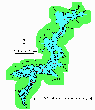
Fig. EUR-22-01
Bathymetric map [m].
- Water temperature [deg C]
| Station 1, 1978 |
| Depth [m] | Jan | Feb | Mar | Apr | May | Jun | Jul | Aug | Sep | Oct | Nov | Dec |
|---|
| 0.5*1 | 4.8 | 4.5 | - | 7.5 | 14 | 14.5 | 16.5 | 17.5 | - | - | 13.0 | 8.0 |
| 6 | 4.8 | 4.5 | 7.0*2 | 7.5 | 14 | 14.5 | 16.5 | 17.5 | 16*2 | - | 13.0 | 8.0 |
| 12 | 4.8 | 4.5 | - | 7.5 | 13 | 14.5 | 16.0 | 17.5 | - | - | 13.0 | 8.0 |
| 18 | 4.8 | 4.5 | - | 7.5 | 11 | 14.5 | 16.0 | 17.5 | - | - | 13.0 | 8.0 |
| 21 | 4.8 | - | - | - | 11 | - | - | 17.5 | - | - | 12.5 | 8.0 |
| 24 | - | - | - | - | - | 14.5 | 16.0 | - | - | - | - | - |
| *1 Surface. *2 0.5-6 m. |
- Freezing period: None.
- Mixing type: Monomictic.
- Notes on water mixing and thermocline formation
Generally well mixed. Thermocline formation in summer months usually short- lived, particularly in the upper lake.
E. LAKE WATER QUALITY (Q)
E1 TRANSPARENCY [m]
| Station 1, 1986 |
| Depth [m] | Jan | Feb | Mar | Apr | May | Jun | Jul | Aug | Sep | Oct | Nov | Dec |
|---|
| | - | - | - | - | - | 2.3 | 2.0 | 1.4 | 2.2 | - | 0.7 | - |
E2 pH
| Station 1, 1986 |
| Depth [m] | Jan | Feb | Mar | Apr | May | Jun | Jul | Aug | Sep | Oct | Nov | Dec |
|---|
| 0.5 | - | - | - | - | - | 8.27 | 8.34 | 8.24 | 8.31 | - | 8.27 | - |
| 6 | - | - | - | - | - | 8.26 | 8.33 | 8.21 | 8.33 | - | - | - |
| 12 | - | - | - | - | - | 8.04 | 8.33 | 8.21 | 8.30 | - | - | - |
| 18 | - | - | - | - | - | - | 8.34 | 8.15 | 8.19 | - | - | - |
| 20 | - | - | - | - | - | 7.94 | - | 8.11 | - | - | - | - |
| 24 | - | - | - | - | - | - | 8.33 | - | 8.10 | - | - | - |
E4 DO [mg l-1]
| Station 1, 1986 |
| Depth [m] | Jan | Feb | Mar | Apr | May | Jun | Jul | Aug | Sep | Oct | Nov | Dec |
|---|
| 0.5 | - | - | - | - | - | 10.2 | 8.3 | 10.2 | 8.8 | - | 9.4 | - |
| 6 | - | - | - | - | - | 9.6 | 8.3 | 9.3 | 8.7 | - | - | - |
| 12 | - | - | - | - | - | 9.0 | 8.0 | 8.5 | 8.3 | - | - | - |
| 18 | - | - | - | - | - | - | 7.8 | 8.5 | 7.9 | - | - | - |
| 20 | - | - | - | - | - | 7.3 | - | 8.4 | - | - | - | - |
| 24 | - | - | - | - | - | - | 7.9 | - | 5.9 | - | - | |
E6 CHLOROPHYLL CONCENTRATION [micro g l-1]
| Station 1, 1986 |
| Depth [m] | Jan | Feb | Mar | Apr | May | Jun | Jul | Aug | Sep | Oct | Nov | Dec |
|---|
| 0.5 | - | - | - | - | - | 11.1 | 25.8 | 38.8 | 12.6 | - | 21.2 | - |
| 6 | - | - | - | - | - | 15.3 | 22.7 | 33.1 | 11.6 | - | - | - |
| 12 | - | - | - | - | - | 13.8 | 22.3 | 31.4 | 9.0 | - | - | - |
| 18 | - | - | - | - | - | - | 22.3 | - | 6.7 | - | - | - |
| 20 | - | - | - | - | - | 16.3 | - | - | - | - | - | - |
| 24 | - | - | - | - | - | - | - | - | 6.5 | - | - | - |
E7 NITROGEN CONCENTRATION
| Station 1, 1986 |
| Depth [m] | Jan | Feb | Mar | Apr | May | Jun | Jul | Aug | Sep | Oct | Nov | Dec |
|---|
| 0.5 | - | - | - | - | - | 0.005 | 0.01 | 0.03 | 0.035 | - | 0.035 | - |
| 6 | - | - | - | - | - | 0.005 | 0.01 | 0.03 | 0.025 | - | - | - |
| 12 | - | - | - | - | - | 0.055 | 0.015 | 0.04 | 0.025 | - | - | - |
| 18 | - | - | - | - | - | - | 0.02 | 0.07 | 0.05 | - | - | - |
| 20 | - | - | - | - | - | 0.22 | - | 0.07 | - | - | - | - |
| 24 | - | - | - | - | - | - | - | 0.015 | 0.19 | - | - | - |
| Station 1, 1986 |
| Depth [m] | Jan | Feb | Mar | Apr | May | Jun | Jul | Aug | Sep | Oct | Nov | Dec |
|---|
| 0.5 | - | - | - | - | - | 0.46 | 0.56 | 1.00 | 0.50 | - | 0.90 | - |
| 6 | - | - | - | - | - | 0.42 | 0.56 | 1.06 | 0.50 | - | - | - |
| 12 | - | - | - | - | - | 0.52 | 0.56 | 1.08 | 0.48 | - | - | - |
| 18 | - | - | - | - | - | - | 0.56 | 1.24 | 0.48 | - | - | - |
| 20 | - | - | - | - | - | 0.56 | - | 1.2 | - | - | - | - |
| 24 | - | - | - | - | - | - | 0.56 | - | 0.60 | - | - | - |
E8 PHOSPHORUS CONCENTRATION
| Station 1, 1978 |
| Depth [m] | Jan | Feb | Mar | Apr | May | Jun | Jul | Aug | Sep | Oct | Nov | Dec |
|---|
| 0.05 | - | - | - | - | - | 0.023 | 0.028 | 0.043 | 0.045 | - | 0.023 | - |
| 6 | - | - | - | - | - | 0.020 | 0.025 | 0.045 | 0.040 | - | - | - |
| 12 | - | - | - | - | - | 0.038 | 0.023 | 0.045 | 0.040 | - | - | - |
| 18 | - | - | - | - | - | - | 0.023 | - | 0.040 | - | - | - |
| 20 | - | - | - | - | - | 0.033 | - | 0.043 | - | - | - | - |
| 24 | - | - | - | - | - | - | 0.033 | - | 0.044 | - | - | - |
E10 PAST TRENDS
| Station 1, 1978 (cf. E1) |
| Depth [m] | Jan | Feb | Mar | Apr | May | Jun | Jul | Aug | Sep | Oct | Nov | Dec |
|---|
| | 1.5 | 1.3 | 1.4 | 2.0 | 2.9 | 2.5 | - | 3.0 | 3.3 | - | 1.9 | 1.7 |
| Station 1, 1978 |
| Depth [m] | Jan | Feb | Mar | Apr | May | Jun | Jul | Aug | Sep | Oct | Nov | Dec |
|---|
| 0.5 | 7.9 | 7.95 | - | 8.35 | 8.0 | 8.1 | 8.15 | 8.15 | - | - | 8.10 | - |
| 6 | 7.9 | 8.0 | 8.4* | 8.3 | 7.9 | 8.1 | 8.2 | 8.2 | 8.55* | - | 8.20 | - |
| 12 | 7.9 | 8.05 | - | 8.4 | 7.9 | 8.1 | 8.15 | 8.2 | - | - | 8.15 | - |
| 18 | 8.0 | 8.1 | - | 8.4 | 7.9 | 8.1 | 8.15 | 8.1 | - | - | 8.10 | - |
| 21 | 7.9 | - | - | - | 8.0 | - | - | 8.0 | - | - | 8.20 | - |
| 24 | - | - | - | - | - | 8.1 | 8.15 | - | - | - | - | - |
| * 0.5-6 m. |
| Station 1, 1978 (cf. E4) |
| Depth [m] | Jan | Feb | Mar | Apr | May | Jun | Jul | Aug | Sep | Oct | Nov | Dec |
|---|
| 0.5 | 93 | 90 | - | 97 | 92 | 89 | 90 | 102 | - | - | 92 | 88 |
| 6 | 95 | 90 | 93* | 95 | 91 | 93 | 88 | 99 | - | - | 92 | 89 |
| 12 | 91 | 90 | - | 93 | 83 | 94 | 89 | 95 | - | - | 92 | 89 |
| 18 | 94 | 97 | - | 96 | 70 | 97 | 89 | 81 | - | - | 90 | 84 |
| 21 | 92 | - | - | - | 69 | - | - | 71 | - | - | 90 | 84 |
| 24 | - | - | - | - | - | 94 | 89 | - | - | - | - | - |
| * 0.5-6 m. |
- Chlorophyll concentration [micro g l-1]
| Station 1, 1978 (cf. E6) |
| Depth [m] | Jan | Feb | Mar | Apr | May | Jun | Jul | Aug | Sep | Oct | Nov | Dec |
|---|
| 0.5 | 1.7 | 2.7 | - | - | - | - | - | - | - | - | - | 15.7 |
| 6 | 1.0 | 2.7 | 8.8* | 10.9* | 2.0* | 5.1* | 4.8* | 10.2* | 9.6* | - | 15.0 | 6.8* |
| 12 | 1.7 | - | - | - | - | - | 5.1 | 9.6 | - | - | 14.3 | - |
| 18 | - | 2.7 | - | 20.2 | 0.7 | 5.1 | 5.1 | 1.4 | - | - | 17.1 | - |
| 21 | 1.7 | - | - | - | - | - | - | - | - | - | 16.4 | - |
| 24 | - | - | - | - | - | - | 4.4 | - | - | - | - | - |
| * 0.5-6 m. |
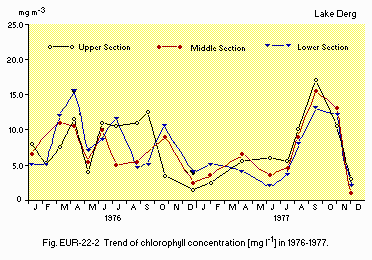
Fig. EUR-22-02
Trend of chlorophyll concentration [mg l-1] in 1976-1977.
| Station 1, 1978 (cf. E7) |
| Depth [m] | Jan | Feb | Mar | Apr | May | Jun | Jul | Aug | Sep | Oct | Nov | Dec |
|---|
| 0.5 | 0.01 | 0.04 | - | Tr. | 0.035 | 0.02 | 0.03 | 0.015 | - | - | 0.03 | - |
| 6 | 0.02 | 0.03 | 0.02* | Tr. | 0.035 | 0.02 | 0.04 | 0.015 | 0.01* | - | 0.03 | - |
| 12 | 0.01 | 0.02 | - | Tr. | 0.055 | 0.02 | 0.04 | 0.015 | - | - | 0.035 | - |
| 18 | N.D. | 0.02 | - | Tr. | 0.11 | 0.02 | 0.035 | 0.01 | - | - | 0.04 | - |
| 21 | 0.015 | - | - | - | 0.125 | - | - | 0.01 | - | - | 0.025 | - |
| 24 | - | - | - | - | - | 0.03 | 0.045 | - | - | - | - | - |
| * 0.5-6 m. |
| Station 1, 1978 (cf. E7) |
| Depth [m] | Jan | Feb | Mar | Apr | May | Jun | Jul | Aug | Sep | Oct | Nov | Dec |
|---|
| 0.5 | 0.88 | 1.16 | 0.98* | 1.08 | 1.20 | 0.78 | 0.70 | 0.72 | 0.46* | - | 0.26 | - |
| 6 | 0.91 | 1.20 | - | 1.08 | 1.18 | 0.78 | 0.70 | 0.72 | - | - | 0.28 | - |
| 12 | 0.88 | 1.24 | - | 1.10 | 1.06 | 0.78 | 0.72 | 0.72 | - | - | 0.28 | - |
| 18 | 0.92 | 1.24 | - | 1.10 | 1.14 | 0.78 | 0.72 | 0.92 | - | - | 0.28 | - |
| 21 | 1.34 | - | - | - | 1.12 | - | - | 0.92 | - | - | 0.28 | - |
| 24 | - | - | - | - | - | 0.80 | 0.72 | - | - | - | - | - |
| * 0.5-6 m. |
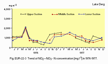
Fig. EUR-22-03
Trend of NO2 + NO3-N concentration [mg l-1] in 1976-1977.
| Station 1, 1978 (cf. E8) |
| Depth [m] | Jan | Feb | Mar | Apr | May | Jun | Jul | Aug | Sep | Oct | Nov | Dec |
|---|
| 0.5 | 0.020 | 0.038 | - | 0.020 | 0.003 | 0.010 | 0.015 | 0.013 | - | - | 0.020 | - |
| 6 | 0.030 | 0.038 | 0.030* | 0.020 | 0.005 | 0.008 | 0.010 | 0.010 | 0.008* | - | 0.023 | 0.35* |
| 12 | 0.022 | 0.035 | - | 0.020 | 0.005 | 0.008 | 0.010 | 0.015 | - | - | 0.020 | - |
| 18 | 0.027 | 0.038 | - | 0.015 | 0.008 | 0.008 | 0.013 | 0.010 | - | - | 0.020 | - |
| 21 | 0.020 | - | - | - | 0.008 | - | - | 0.010 | - | - | 0.020 | - |
| 24 | - | - | - | - | - | 0.008 | 0.010 | - | - | - | - | - |
| * 0.5-6 m. |
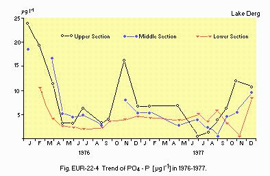
Fig. EUR-22-04
Trend of PO4-P [micro g l-1], 1976-1977.
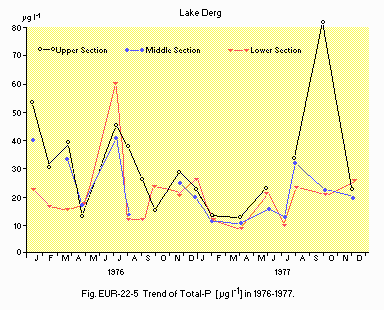
Fig. EUR-22-05
Trend of Total-P [micro g l-1], 1976-1977.
F. BIOLOGICAL FEATURES (Q)
F1 FLORA
- Emerged macrophytes
Inula salicina, Sagittaria spp., Equisetum variegatum, Phragmites spp., Juncus spp.
- Floating macrophytes: Lemna spp.
- Submerged macrophytes: Sparganium spp., Chara spp.
- Phytoplankton
Winter: Aphanizomenon flos-aquae, Oscillatoria spp., Stephanodiscus astraea. Spring: S. astraea, Tabellaria spp., Melosira italica, Asterionella formosa. Summer: Oscillatoria spp., Tabellaria spp., Melosira granulata. Autumn: Oscillatoria spp., Tabellaria spp., M. granulata.
F2 FAUNA
- Zooplankton
Cladocera (Daphnia hyalina galeata, D. hyalina cacustis, Bosmina sp.), Copepoda (Diaptomus spp., Cyclops spp.), Rotifera (Keratella cochlearis, K. quadrata, K. longispina, Ascomorpha spp., Asplanchna spp.).
- Benthos
Playthelminthes (Planaria torva), Hirudinea (Glossiphonia complanata), Crustacea )Gammarus duebeni), Ephemeroptera (Heptagenia sulphurea), Trichoptera (Polycentropus flavomaculatus), Coleoptera (Oulimnius tuberculatus), Mollusca (Bithynia tentaculata, Limnaea peregra, Theodoxus fluviatilis, Valvata piscinalis).
- Fish
Salmo salar, S. trutta, Perca fluviatilis, Tinca tinca, Esox lucius, Abramis brama, Scardinius erythrophthalmus, Anguilla anguilla*, Coregonus pollan elegans, Osmerus eperlanus. * Economically important.
F4 BIOMASS: Fig. EUR-22-06.
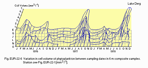
Fig. EUR-22-06
Variation in cell volume of phytoplankton between sampling dates in 6 m composite samples. Stations see Fig. EUR-22-0l [mm3 l-1].
F5 FISHERY PRODUCTS
- Annual fish catch [metric tons]
1986: 50.
G. SOCIO-ECONOMIC CONDITIONS (Q)
G1 LAND USE IN THE CATCHMENT AREA
| 1980 |
| Area [km2] | [%] |
|---|
| - Natural landscape |
| Woody vegetation | 514 | 5 |
| Herbaceous vegetation | 514 | 5 |
| Peat land | 2,056 | 20 |
| - Agricultural land |
| Crop field | 514 | 5 |
| Pasture land | 6,168 | 60 |
| - Residential area | 103 | 1 |
| - Others | 411 | 4 |
| - Total | 10,280 | 100 |
- Main types of woody vegetation
Mixed evergreen predominate with lesser amounts of old deciduous broadleaf.
- Main kinds of crops: Grass for pasture and silage.
- Levels of fertilizer application on crop fields: Moderate to light.
- Trends of change in land use: Increase in exploitation of peatland.
G2 INDUSTRIES IN THE CATCHMENT AREA AND THE LAKE
- Major industries
Milk and meat processing, light mechanical engineering, electrical engineering, chemical, coal mining, timber products, foodstuffs, electrical generation, peat products.
- Numbers of domestic animals in the catchment area
Cattle 1,160,000, sheep 540,000, swine 88,000, poultry 980,000.
G3 POPULATION IN THE CATCHMENT AREA
| 1981 |
| Population | Population density [km-2] | Major cities (population) |
|---|
| Total | 280,000 | 28 | Athlone (14,000) |
H. LAKE UTILIZATION (Q)
H1 LAKE UTILIZATION
Source of water, navigation and transportation, sightseeing and tourism,
recreation (swimming, sport-fishing, yachting) and fisheries.
H2 THE LAKE AS WATER RESOURCE
| l980s |
| Use rate [m3 day-1] |
|---|
| Domestic | 36,000 |
| Industrial | Not known but small |
| Power plant | 400 |
I. DETERIORATION OF LAKE ENVIRONMENTS AND HAZARDS (Q)
I1 ENHANCED SILTATION
- Extent of damage: Not serious.
- Supplementary notes
Considerable amounts of peat silt, originating in peat workings upstream of Lough Derg, are being washed into and settling in the lake. Concern that this silt was eliminating Ephemera dancia (mayfly, important element of Salmo trutta diet) was not substantiated by an investigation of the insects distribution in the lake, which found no evidence to support a connection between the distribution of E. danica and the presence of peat silt. This peat silt may be a significant source of bio-available phosphorus and the recent increase in the level of algal development in the lake may be associated with greater activity in peat workings upstream of the lake.
I3 EUTROPHICATION
- Nuisance caused by eutrophication
Unusual algal bloom Oscillatoria spp., Microcystis spp., Anabaena spp. usually mixed with blue- green populations. Disturbed filtration in cleaning beds. Foul odour of tap water. Harms to fishery products and kinds of products damaged: Oscillatoria clogging gills of Salmo salar fingerlings at salmon hatchery downstream of the lake. Complaints from lake shore inhabitants.
- Nitrogen and phosphorus loadings to the lake [t yr-1]
| Sources | Total |
| T-N | 6,245* |
| T-P | 215 |
| * Dissolved inorganic nitrogen. |
- Supplementary notes
Since the 1976-1978 investigation there has been a marked increase in the levels of planktonic algal development in Lough Derg placing the lake in the eutrophic category according to the O.E.C.D. scheme. There has been no corresponding increase in the phosphorus loading on the lake. However, it is possible that bio-available phosphorus is being released by the action of U.V. radiation on the humic material resulting from increase in peat workings upstream of the lake.
I4 ACIDIFICATION
- Extent of damage: None.
- Past trends in hydrogen ion concentration in lake water
The weekly measurements of pH carried out between March 1922 and March 1923, at a point on the River Shannon 1 km upstream of Lough Derg, ranged from 7.8- 8.3, and in the upper section of the lake ranged from 8.0-8.4. While these values are strictly not comparable with more recent observations on pH in the lake due to differing methodology they do indicate that no significant change has taken place in this well buffered water (alkalinity: -175 mg CaCO3 l-1).
J. WASTEWATER TREATMENTS (Q)
J1 GENERATION OF POLLUTANTS IN THE CATCHMENT AREA
c) Limited pollution with wastewater treatment.
- Supplementary notes
Extensive peat mining activity immediately upstream of the lake results in substantial influx of peat silt in the northern section of lake which may release bio-available phosphorus.
J2 APPROXIMATE PERCENTAGE DISTRIBUTION OF POLLUTANT LOADS
| [%] |
|---|
| - Non-point sources | 94 |
| - Point sources |
| Municipal | 3 |
| - Industrial | 2 |
| - Aeolian | 1 |
| - Total | 100 |
J3 SANITARY FACILITIES AND SEWERAGE
- Percentage of municipal population in the catchment area provided with
adequate sanitary facilities (on-site treatment systems) or public sewerage: 100%.
- Percentage of rural population with adequate sanitary facilities (on-site
treatment systems): 75%.
- Municipal wastewater treatment systems
No. of tertiary treatment systems: 1 (oxidation ditch with simultaneous precipitation of P.). No. of secondary treatment systems: 45 (oxidation ditches). No. of primary treatment systems: 33 (Imhoff tanks).
- Industrial wastewater treatment systems
No. of industrial wastewater treatment systems: 42 (oxidation ditches).
L. DEVELOPMENT PLANS
In 1986 a water quality management plan was completed for Lough Derg and the
Lower Shannon River which provided an assessment of the water resources in the
catchment and reported on the current water quality in the lakes and rivers in
the system. The beneficial uses of the waters were identified and the water
quality standards and criteria necessary to support these uses were specified.
An assessment of the capacity of the system to accommodate the waste loads was
made. The plan lists areas where remedial measures are necessary to restore
unsatisfactory water quality conditions and outlines future measures necessary
to retain satisfactory water conditions taking account of projected future
development. In relation to Lough Derg the plan proposes that there be no
further direct discharges from point sources to the lake or to streams within
5 km of the lake, unless P removal is provided; that strict control be placed
on the land disposal of farm wastes within 5 km of the lake; and that further
investigations be undertaken to determine the causes of the recent decline in
the water quality.
M. LEGISLATIVE AND INSTITUTIONAL MEASURES FOR UPGRADING LAKE ENVIRONMENTS (Q)
M1 NATIONAL AND LOCAL LAWS CONCERNED
- Names of the laws (the year of legislation)
- Local Government (Water Pollution) Act (1977)
- Planning Acts (1963-1984)
- Fisheries Acts (1959-1980)
- Responsible authorities
- Glare County Council
- Galway County Council
- Tipperary County Council (North Riding)
- Shannon Regional Fisheries Board
- Main items of control
- Prohibition of discharges to waters except by licence (sewage discharges excluded).
- Control development of land including buildings likely to generate wastes.
- Prohibits pollution of fishery waters.
M2 INSTITUTIONAL MEASURES
- Glare County Council
- Galway County Council
- Tipperary County Council (North Riding)
M3 RESEARCH INSTITUTES ENGAGED IN THE LAKE ENVIRONMENT STUDIES
- An Foras Forbartha
N. SOURCES OF DATA
- Questionnaire was filled by Dr. J. Bowman, The National Institute for Physical Planning and Construction Research, Dublin, based on the data obtained from the following sources.
- Charlesworth, J. K. (1963) Proc. Roy. Irish Acad., 63. B. 3.
- Toner, P. F. & Clabby, K. J. (1975) An Foras Forbartha, Nov. 1975. WR/C122.
- Bagnall, G. (1975) J. Instn. Public Admin. 25, Special Issue, pp. 153, 159.
- Bowman, J. J. (1985) An Foras Forbartha, WR/L12.

