
LAKE PAAJARVI
Reutine sampling at the designated station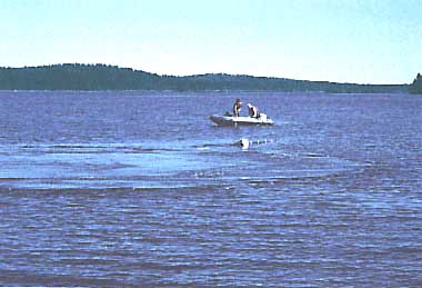
Photo: J. Syrjamaki
A. LOCATION
- Hame, Finland.
- 61:04N, 25:08E; 103 m above sea level.
B. DESCRIPTION
-
Lake Paajarvi is located approximately 100 km north from Helsinki in Finland, a well-known lake country having about 60,000 lakes. This small lake is frozen for nearly five months of the year, though snow accumulation is not heavy. It is deeper than many other lakes in Finland, but the deepest portion occupies only a small part. It is surrounded by simple but beautiful vegetation, mainly northern coniferous forest of pine and spruce. In the fall, broadleaf trees growing mixed among conifers come ablaze with autumnal tints of yellow and gold, offering the typical scenic beauty of northern Europe.
The concentration of dissolved oxygen in the lake water is high both at the surface and along the bottom, while the pH value is somewhat acidic presumably owing to acid rain which is becoming a serious problem in Scandinavian countries. The concentration of chlorophyll indicates a low level of productivity. Population density in the drainage basin is extremely low, and the lake is mainly used for swimming, sport.fishing and sailing. However, the progress of eutrophication by nutrient loading from fertilized crop fields and forests is alarming. The lake is therefore under continuous study by the Lammi Biological Station near the lake, as an area for reference in the comparative study of eutrophication (1, 2).
C. PHYSICAL DIMENSIONS (Q)
| Surface area [km2] | 14 |
| Volume [km3] | 0.206 |
| Maximum depth [m] | 87 |
| Mean depth [m] | 14 |
| Water level | Regulated |
| Normal range of annual water level fluctuation [m] | 0.6 |
| Length of shoreline [km] | 33 |
| Residence time [yr] | 3.5 |
| Catchment area [km2] | 255 |
D. PHYSIOGRAPHIC FEATURES
D1 GEOGRAPHICAL- Bathymetric map: Fig. EUR.20-1.
- Number of outflowing rivers and channels (name): 1 (Teuronjoki R.)(Q).
- Climatic data at Lammi Biological Station*, 1930-1980 (Q)
| Mean temp. [deg C] | ||||||||||||
| Jan | Feb | Mar | Apr | May | Jun | Jul | Aug | Sep | Oct | Nov | Dec | Ann. |
|---|---|---|---|---|---|---|---|---|---|---|---|---|
| -7.9 | -8.0 | -4.5 | 2.1 | 8.8 | 14.0 | 16.7 | 14.8 | 9.7 | 4.0 | -0.4 | -4.2 | 3.8 |
| Precipitation [mm] | ||||||||||||
| 40 | 30 | 27 | 33 | 42 | 49 | 70 | 76 | 60 | 60 | 49 | 44 | 580 |
| * 400 m from the lake. | ||||||||||||
- Snowfall
Period on snowfall (1961-1971): 7 December-23 April. Mean depth of maximum snow accumulation: 0.45 m.
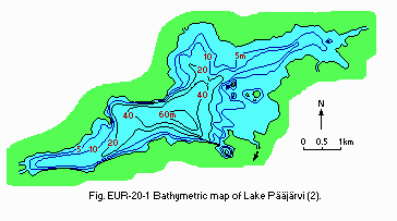
Bathymetric map (2).
- Water temperature [deg C](Q)
| 1972 | |||||||||
| Depth [m] | Jan-Feb-Mar-Apr | May | Jun | Jul | Aug | Sep | Oct | Nov | Dec |
|---|---|---|---|---|---|---|---|---|---|
| S* | Ice cover | 4 | 15 | 21 | 19 | 13 | 7 | 4 | 0.5 |
| * Surface. | |||||||||
- Freezing period: 5 December-5 May.
- Notes on water mixing and thermocline formation
The thermocline is formed from June to September.
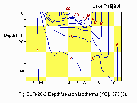
Depth/season isotherms [deg C], 1973 (3).
E. LAKE WATER QUALITY
E2 pH (Q)- Surface water, 1971: 6.5 (February), 6.7-7.1 (June-July).
| Lake centre, 1972-1973 | ||||||||||||
| Depth [m] | Jan | Feb | Mar | Apr | May | Jun | Jul | Aug | Sep | Oct | Nov | Dec |
|---|---|---|---|---|---|---|---|---|---|---|---|---|
| 0 | - | - | - | 11.7 | 11.9 | 9.7 | 8.5 | 9 | 10 | 10.0 | 10.9 | 12.0 |
| 5 | 12.8 | - | 12.5 | 11.9 | 11.8 | 9.7 | 8.4 | 8.9 | 9.8 | 10.0 | 11.0 | 12.1 |
| 10 | 12.5 | - | 12.2 | 11.9 | 11.7 | 10.6 | 9.4 | 8.2 | 9.8 | 10.0 | 11.0 | 12.1 |
| 20 | 12.4 | - | 12.1 | 12.0 | 11.7 | 11.0 | 10.4 | 9.1 | 9.6 | 10.0 | 11.0 | 12.0 |
| 30 | 12.3 | - | 11.8 | 12.0 | 11.8 | 11.1 | 10.7 | 9.9 | 9.6 | 10.0 | 10.9 | 12.1 |
| 40 | 12.3 | - | 12.0 | 11.6 | 11.7 | 11.3 | 10.7 | 9.8 | 9.7 | 10.0 | 11.0 | 12.0 |
| 50 | 12.1 | - | 11.7 | - | 11.7 | 11.3 | 10.7 | 9.8 | 9.7 | 10.0 | 11.0 | 11.9 |
- Chlorophyll a [micro g l-1], 1976
| Depth [m] | Winter | Spring | Summer | Autumn |
|---|---|---|---|---|
| E* | 0.6 | 3.5 | 4.1 | 1.2 |
| * Euphotic zone. | ||||
- Total-N [mg l-1], 1976
| Depth [m] | Winter | Spring | Summer | Autumn |
|---|---|---|---|---|
| E* | 1.05 | 1.10 | 1.20 | 1.30 |
| * Euphotic zone. | ||||
- Total-P [mg l-1], 1976
| Depth [m] | Winter | Spring | Summer | Autumn |
|---|---|---|---|---|
| E* | 0.007 | 0.019 | 0.013 | 0.004 |
| * Euphotic zone. | ||||
F. BIOLOGICAL FEATURES
F1 FLORA (Q)- Emerged macrophytes
Carex rostrata, Equisetum fluviatile, Phragmites communis. - Floating macrophytes
Potamogeton natans, Sparganium friesii, Nymphaea candida. - Submerged macrophytes
Potamogeton perfoliatus, Eleocharis acicularis, Subularia aquatica, Isoetes lacustris. - Phytoplankton
Croomonas acuta, Cryptomonas erosa, Anabaena flos-aquae, Ankistrodesmus falcatus, Selenastrum capricornutum, Synura uvella, Uroglena americana, Asterionella formora, Melosira distans, Oscillatoria limosa, Croococcus turgidus.
- Zooplankton
Daphnia cristata, D. cucullata, Bosmina coregoni, Asplanchna priodonta, A. herricki, Limnocalanus macrurus, Heterocope appendiculata, Eudiaptomus gracilis. - Benthos
Asellus aquaticus, Pallasea quadrispinosa, Mysis relicta, Caenis horaria, Heptagenia sulphurea, Cryptochironomus defectus, Ironus tenuicandatus, Attheyella crassa, Anodonta piscinalis. - Fish
Rutilus rutilus, Perca fluviatilis, Lota lota, Esox lucius, Coregonus albula.
| 1972 | ||||
| Winter | Spring | Summer | Autumn | Ann. |
|---|---|---|---|---|
| 0.1 | 0.1 | 0.2 | 0.1 | 0.1 |
- Fish [kg ha-1]
1984: 15-20.
- Annual fish catch
Not estimated (sport-fishing only).
G. SOCIO-ECONOMIC CONDITIONS
G1 LAND USE IN THE CATCHMENT AREA(Q)| 1982 | ||
| Area[km2] | [%] | |
|---|---|---|
| - Natural landscape | ||
| Woody and herbaceous vegetation | 144 | 56.5 |
| Swamp | 25 | 9.8 |
| Others | 18 | 7.1 |
| - Agricultural land | 45 | 17.6 |
| - Residential area | 1 | 0.4 |
| - Others | 11 | 4.3 |
| - Total | 244 | 95.7 |
- Types of important forest (main genera)
Conifer forest; deciduous broadleaf forest (Betula,Alnus). - Types of important herbaceous vegetation: Peatland (bog, swamp).
- Main kinds of crops: Wheat, barley, rye and potato.
- Agriculture
Number of persons engaged: ca. 50. Main products: Wheat, barley, rye and potato. - Supplementary notes
The drainage basin has not yet become greatly industrialized and only small- scale industry is found within the basin.
| 1988 | |||
| Population | Population density [km-2] | Major cities (population) | |
|---|---|---|---|
| Total | 1,100 | 4.3 | None |
H. LAKE UTILIZATION
H1 LAKE UTILIZATION-
Recreation (swimming, sport-fishing, yachting).
I. DETERIORATION OF LAKE ENVIRONMENTS AND HAZARDS (3)
I1 ENHANCED SILTATION- Extent of damage: Not serious.
- Present status: None.
- Nuisance caused by eutrophication (Q).
Fertilization in agriculture and forestry slightly eutrophies the lake. - Nitrogen and phosphorus loadings to the lake [t yr-1](1)
| 1976 |
| T-N: 74.25. |
| T-P: 4.05. |
J. WASTEWATER TREATMENTS
- Public sewerage system: Not present (Q).
K. IMPROVEMENT WORKS IN THE LAKE (3)
-
None.
L. DEVELOPMENT PLANS (3)
-
None.
M. LEGISLATIVE AND INSTITUTIONAL MEASURES FOR UPGRADING LAKE ENVIRONMENTS
M1 NATIONAL AND LOCAL LAWS CONCERNED (Q)- Responsible authorities: Finnish National Board of Waters.
N. SOURCES OF DATA
- Questionnaire filled by Dr. J. Syrjamaki, Lammi Biological Station, University of Helsinki, Lammi.
- Ruuhijarvi, R. (1974) A general description of the oligotrophic lake Paajarvi, southern Finland and the ecological studies on it. Ann. Bot. Fennici, 11: 95-104.
- Ryding, S.-O. (compiled by)(1980) Monitoring of Inland Waters; OECD Eutrophication Programme the Nordic Project. Report from the Working Group for Eutrophication Research. 207 pp. NORDFORSK.
- Personal communication.
