
LAKE PAIJANNE
A view of the sub-basin of Tehinselika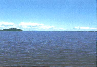
Photo: A. Makela
A. LOCATION
- Keski-Soumi, Hame, and Mikkeli, Finland.
- 61:14-62:15N, 25:10-26:00E; 78 m above sea level.
B. DESCRIPTION
-
Lake Paijanne is the second largest lake in Finland and the major lake of the River Kymijoki watercourse in central Finland. The basin of the lake lies in the old Precambrian primary rock consisting mainly of granite and schist. Loose ground consists mostly of till. The lake was formed after the last glacial period some 8,000 years ago, when the land began to rise with the retreat of ice and the connection with the sea was severed.
Lake Paijanne is 120 km long and its width varies from 1 to 28 km. There are several separate basins along the lake. Nutrient loadings mainly enter the northern part of the lake. The water quality is therefore poorer in the northern than in the southern part.
The total area of the drainage basin of Lake Paijanne is 25 times as large as the lake itself. Most of the basin is covered by forests, the proportion of farmland being only about 10%, and forested peatlands account for 25%. From the peatlands, humic substances are discharged to the lake. The forests consist mainly of pine and spruce. The population in the drainage basin is about 400,000, of which 150,000 live near the lake. There are some 30,000 holiday cottages along the shore of the lake.
Lake Paijanne is an important water resource which supplies drinking water to about 1 million people in the Helsinki metropolitan area. Water is conducted from the lake through a 120 km tunnel. The water quality in northern parts of the lake deteriorated definitely in the 1950's and 1960's. As the result of recent legislative and administrative measures, waste loadings have now diminished substantially and water quality has been steadily improved (Q).
C. PHYSICAL DIMENSIONS (Q)
| Surface area [km2] | 1,100 |
| Volume [km3] | 17.8 |
| Maximum depth [m] | 98 |
| Mean depth [m] | 17 |
| Water level | Regulated |
| Normal range of annual water level fluctuation [m] | 1 |
| Length of shoreline [km] | 1,140* |
| Residence time [yr] | 2.7 |
| Catchment area [km2] | 25,400 |
| * With islands 2,250 km. | |
D. PHYSIOGRAPHIC FEATURES (Q)
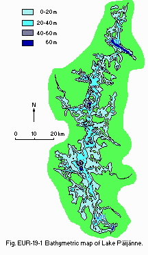
D1 GEOGRAPHICAL- Bathymetric map: Fig. EUR-19-01.
- Names of main islands: Judinsalo (20 km2) and Virmalansaari (30 km2).
- Number of outflowing rivers and channels (name): 1 (Kalkkistenkoski).
- Climatic data at Luonetjarvi, 1931-1960
| Mean temp. [deg C] | ||||||||||||
| Jan | Feb | Mar | Apr | May | Jun | Jul | Aug | Sep | Oct | Nov | Dec | Ann. |
|---|---|---|---|---|---|---|---|---|---|---|---|---|
| -9.4 | -9.2 | -5.4 | -1.4 | 8.1 | 13.3 | 16.3 | 14.1 | 8.8 | 3.0 | -1.6 | -5.8 | 2.6 |
| Precipitation [mm] | ||||||||||||
| 37 | 28 | 25 | 32 | 41 | 56 | 71 | 74 | 63 | 58 | 47 | 40 | 576 |
- Solar radiation: 8.8 MJ m-2 day-1.
Bathymetric map.
- Water temperature [deg C]
| Station 70, 1985 | ||||||||||||
| Depth [m] | Jan | Feb | Mar | Apr | May | Jun | Jul | Aug | Sep | Oct | Nov | Dec |
|---|---|---|---|---|---|---|---|---|---|---|---|---|
| 1 | 0.4 | - | 0.1 | - | 3.7 | 17.7 | - | 18.7 | - | 8.0 | - | - |
| 10 | 1.2 | - | 0.6 | - | 3.7 | 9.1 | - | 15.8 | - | 8.0 | - | - |
| 20 | 2.6 | - | 1.7 | - | 3.7 | 6.2 | - | 7.4 | - | 8.0 | - | - |
| 30 | 2.2 | - | 2.1 | - | 3.7 | 5.6 | - | 6.0 | - | 8.0 | - | - |
| 40 | 2.5 | - | 2.3 | - | 3.7 | 5.4 | - | 5.6 | - | - | - | - |
| 60 | 2.8 | - | 2.6 | - | 3.7 | 5.1 | - | 5.3 | - | - | - | - |
| Station 78, 1985 | ||||||||||||
| 1 | 0.5 | - | 0.5 | - | 5.3 | 11.2 | - | 15.8 | - | - | 5.8 | - |
| 10 | 0.9 | - | 1.0 | - | 5.1 | 11.5 | - | 14.4 | - | - | 5.8 | - |
| 20 | 1.0 | - | 1.2 | - | 5.0 | 11.4 | - | 9.2 | - | - | 5.8 | - |
| 30 | 1.1 | - | 1.5 | - | 4.9 | 11.8 | - | 8.5 | - | - | 5.8 | - |
| B* | 1.3 | - | 1.6 | - | 4.8 | 11.9 | - | 8.3 | - | - | 5.8 | - |
| * Bottom-1. | ||||||||||||
- Freezing period: December-May.
- Mixing type: Dimictic.
E. LAKE WATER QUALITY (Q)
E1 TRANSPARENCY [m]| Station 70, 1985 | ||||||||||||
| Depth [m] | Jan | Feb | Mar | Apr | May | Jun | Jul | Aug | Sep | Oct | Nov | Dec |
|---|---|---|---|---|---|---|---|---|---|---|---|---|
| 2.6 | - | 3.6 | - | 3.7 | 2.4 | 3.0 | 2.4 | 2.8 | 2.9 | - | - | |
| Station 78, 1985 | ||||||||||||
| 2.5 | - | 2.5 | - | 4.5 | 5.4 | 4.7 | 3.3 | 4.9 | - | 3.8 | - | |
| Station 70, 1985 | ||||||||||||
| Depth [m] | Jan | Feb | Mar | Apr | May | Jun | Jul | Aug | Sep | Oct | Nov | Dec |
|---|---|---|---|---|---|---|---|---|---|---|---|---|
| 1 | 6.4 | - | 6.3 | - | 6.5 | 7.2 | - | 6.8 | - | 6.8 | - | - |
| 10 | 6.6 | - | 6.4 | - | 6.5 | 6.6 | - | 6.6 | - | 6.7 | - | - |
| 20 | 6.6 | - | 6.5 | - | 6.5 | 6.5 | - | 6.2 | - | 6.8 | - | - |
| 40 | 6.6 | - | 6.6 | - | 6.5 | 6.5 | - | 6.1 | - | - | - | - |
| 60 | 6.6 | - | 6.6 | - | 6.5 | 6.5 | - | 6.1 | - | - | - | - |
| Station 78, 1985 | ||||||||||||
| 1 | 6.9 | - | 7.0 | - | 6.8 | 7.0 | - | 6.8 | - | - | 7.0 | - |
| 10 | 6.9 | - | 6.9 | - | 6.9 | 7.0 | - | 6.7 | - | - | 7.0 | - |
| 20 | 6.8 | - | 6.9 | - | 6.9 | 6.9 | - | 6.4 | - | - | 7.0 | - |
| 30 | 6.8 | - | 6.9 | - | 6.9 | 6.9 | - | 6.4 | - | - | 7.0 | - |
| B* | 6.8 | - | 6.8 | - | 6.9 | 6.9 | - | 6.4 | - | - | 7.0 | - |
| * Bottom-1. | ||||||||||||
| Station 70, 1985 | ||||||||||||
| Depth [m] | Jan | Feb | Mar | Apr | May | Jun | Jul | Aug | Sep | Oct | Nov | Dec |
|---|---|---|---|---|---|---|---|---|---|---|---|---|
| 1 | 11.0 | - | 10.3 | - | 10.9 | 10.9 | - | 9.5 | - | 10.1 | - | - |
| 10 | 11.7 | - | 12.2 | - | 10.5 | 10.5 | - | 8.2 | - | 10.0 | - | - |
| 20 | 11.6 | - | 12.2 | - | 10.3 | 10.5 | - | 8.9 | - | 10.0 | - | - |
| 30 | 11.8 | - | 11.9 | - | 10.5 | 10.5 | - | 9.3 | - | 10.0 | - | - |
| 40 | 11.3 | - | 11.8 | - | 10.2 | 10.4 | - | 9.5 | - | - | - | - |
| 60 | 11.4 | - | 11.5 | - | 10.7 | 10.5 | - | 9.3 | - | - | - | - |
| Station 78, 1985 | ||||||||||||
| 1 | 13.4 | - | 13.8 | - | 12.6 | 11.2 | - | 9.4 | - | - | 11.3 | - |
| 10 | 13.3 | - | 13.3 | - | 12.6 | 11.5 | - | 9.1 | - | - | 11.3 | - |
| 20 | 13.1 | - | 12.9 | - | 12.4 | 11.4 | - | 9.1 | - | - | 11.1 | - |
| 30 | 12.9 | - | 12.5 | - | 12.5 | 11.8 | - | 9.4 | - | - | 11.2 | - |
| B* | 12.6 | - | 12.0 | - | 12.5 | 11.9 | - | 9.4 | - | - | 11.4 | - |
| * Bottom-1. | ||||||||||||
-
Determined by KMnO4 method.
| Station 70, 1985 | ||||||||||||
| Depth [m] | Jan | Feb | Mar | Apr | May | Jun | Jul | Aug | Sep | Oct | Nov | Dec |
|---|---|---|---|---|---|---|---|---|---|---|---|---|
| 1 | 11 | - | 11 | - | 9.3 | 11 | - | 9.1 | - | 8.5 | - | - |
| 10 | 10 | - | 10 | - | 9.5 | 9.8 | - | 9.0 | - | 8.6 | - | - |
| 20 | 9.7 | - | 9.0 | - | 9.3 | 10 | - | 8.8 | - | 8.6 | - | - |
| 30 | 9.5 | - | 8.1 | - | 9.3 | 9.7 | - | 8.8 | - | 8.4 | - | - |
| 40 | 9.7 | - | 9.0 | - | 9.5 | 9.8 | - | 8.8 | - | - | - | - |
| 60 | 9.8 | - | 8.7 | - | 10 | 9.9 | - | 8.9 | - | - | - | - |
| Station 78, 1985 | ||||||||||||
| 1 | 7.4 | - | 8.0 | - | 6.7 | 7.5 | - | 7.1 | - | - | 7.1 | - |
| 10 | 6.9 | - | 7.8 | - | 7.1 | 7.7 | - | 7.0 | - | - | 7.1 | - |
| 20 | 6.9 | - | 7.5 | - | 7.3 | 7.7 | - | 7.0 | - | - | 7.1 | - |
| 30 | 6.9 | - | 7.3 | - | 7.3 | 7.4 | - | 6.9 | - | - | 7.3 | - |
| *1 | 6.9 | - | 7.2 | - | 7.4 | 7.4 | - | 6.9 | - | - | 7.3 | - |
| *2 | - | - | - | - | - | 7.6 | - | - | - | - | - | - |
| *1 Bottom-1. *2 Bottom. | ||||||||||||
| Station 70, 1985 | ||||||||||||
| Depth [m] | Jan | Feb | Mar | Apr | May | Jun | Jul | Aug | Sep | Oct | Nov | Dec |
|---|---|---|---|---|---|---|---|---|---|---|---|---|
| 0-2 | - | - | - | - | 0.6 | 12.3 | 4.2 | 13 | 9.6 | - | - | - |
| Station 78, 1985 | ||||||||||||
| 0-2 | - | - | - | - | 3.6 | 2.7 | 4.1 | 3.5 | 2.4 | - | - | - |
- Total-N [mg l-1]
| Station 70, 1985 | ||||||||||||
| Depth [m] | Jan | Feb | Mar | Apr | May | Jun | Jul | Aug | Sep | Oct | Nov | Dec |
|---|---|---|---|---|---|---|---|---|---|---|---|---|
| 1 | 0.61 | - | 0.84 | - | 0.67 | 0.59 | - | 0.50 | - | 0.59 | - | - |
| 10 | 0.62 | - | 0.58 | - | 0.67 | 0.60 | - | 0.50 | - | 0.59 | - | - |
| 20 | 0.58 | - | - | - | 0.67 | 0.60 | - | - | - | 0.59 | - | - |
| 40 | 0.56 | - | 0.53 | - | 0.67 | 0.62 | - | 0.61 | - | - | - | - |
| 60 | 0.58 | - | - | - | 0.64 | 0.59 | - | - | - | - | - | - |
| Station 78, 1985 | ||||||||||||
| 1 | 0.57 | - | 0.56 | - | 0.52 | 0.51 | - | 0.44 | - | - | 0.52 | - |
| 10 | 0.48 | - | 0.50 | - | 0.56 | 0.51 | - | 0.44 | - | - | 0.53 | - |
| 20 | 0.50 | - | 0.52 | - | 0.54 | 0.53 | - | 0.51 | - | - | 0.54 | - |
| 30 | 0.50 | - | 0.52 | - | 0.57 | 0.54 | - | - | - | - | 0.54 | - |
| B* | 0.60 | - | 0.51 | - | 0.56 | 0.54 | - | 0.53 | - | - | 0.53 | - |
| * Bottom-1. | ||||||||||||
- Total-P [mg l-1]
| Station 70, 1985 | ||||||||||||
| Depth [m] | Jan | Feb | Mar | Apr | May | Jun | Jul | Aug | Sep | Oct | Nov | Dec |
|---|---|---|---|---|---|---|---|---|---|---|---|---|
| 1 | 0.016 | - | 0.016 | - | 0.015 | 0.026 | - | 0.017 | - | 0.014 | - | - |
| 10 | 0.029 | - | 0.014 | - | 0.018 | 0.017 | - | 0.013 | - | 0.015 | - | - |
| 20 | 0.025 | - | 0.014 | - | 0.016 | 0.015 | - | 0.014 | - | 0.014 | - | - |
| 30 | 0.020 | - | 0.014 | - | 0.019 | 0.014 | - | 0.013 | - | 0.015 | - | - |
| 40 | 0.020 | - | 0.014 | - | 0.020 | 0.016 | - | 0.013 | - | - | - | - |
| 60 | 0.024 | - | 0.013 | - | 0.017 | 0.014 | - | 0.013 | - | - | - | - |
| Station 78, 1985 | ||||||||||||
| 1 | 0.010 | - | 0.009 | - | 0.008 | 0.008 | - | 0.010 | - | - | 0.010 | - |
| 10 | 0.009 | - | 0.010 | - | 0.007 | 0.011 | - | 0.006 | - | - | 0.009 | - |
| 20 | 0.009 | - | 0.009 | - | 0.007 | 0.008 | - | 0.007 | - | - | 0.010 | - |
| 30 | 0.010 | - | 0.009 | - | 0.007 | 0.007 | - | 0.007 | - | - | 0.011 | - |
| B* | 0.012 | - | 0.011 | - | 0.008 | 0.006 | - | 0.007 | - | - | 0.010 | - |
| * Bottom-1. | ||||||||||||
- COD [mg l-1]
| Stn. | 1970 | 1973 | 1974 | 1975 | 1976 | 1977 | 1978 | 1979 | 1980 | 1981 | 1982 | 1983 | 1984 | 1985 | 1986 |
|---|---|---|---|---|---|---|---|---|---|---|---|---|---|---|---|
| 70 | - | 12 | 12 | 12 | 11 | 10 | 10 | 10 | 10 | 10 | 11 | 10 | 9 | 9 | 8 |
| 78 | 11 | 8 | 8 | 9 | 9 | 8 | 8 | 7 | 7 | 8 | 9 | 8 | 8 | 7 | 7 |
- Total-P [micro g l-1]
| Stn. | 1970 | 1973 | 1974 | 1975 | 1976 | 1977 | 1978 | 1979 | 1980 | 1981 | 1982 | 1983 | 1984 | 1985 | 1986 |
|---|---|---|---|---|---|---|---|---|---|---|---|---|---|---|---|
| 70 | - | 22 | 23 | 19 | 20 | 20 | 17 | 20 | 18 | 19 | 18 | 17 | 17 | 18 | 16 |
| 78 | 10 | 0 | 8 | 11 | 10 | 9 | 9 | 10 | 10 | 10 | 10 | 9 | 9 | 10 | 8 |
F. BIOLOGICAL FEATURES (Q)
F1 FLORA- Emerged macrophytes
Phragmites australis, Equisetum fluviatile, Glyceria maxima, Carex rostrata, C. vesicaria, C. acuta. - Floating macrophytes
Nuphar lutea, Nymphaea spp., Potamogeton natans, Polygonum amphibium. - Submerged macrophytes
Potamogeton gramineus, Elodea canadensis, Myriophyllum alterniflorum, Sparganium spp., Ceratophyllum demersum, Isoetes lacustris, I. echinospora. - Phytoplankton
Rhodomonas minuta, Cryptomonas spp., Asterionella formosa, Melosira italica v. tenuissima, Fragilaria spp., Tabellaria fenestrata, Aphanizomenon flos-aquae, Chlamydomonas spp., Chrysococcus spp.
- Zooplankton
Northern lake Asplanchna priodonta, Conochilus hippocrepis, C. unicornis, Kellicottia longispina, Keratella cochlearis, Polyarthra major, P. remata, P. vulgaris, Synchaeta sp., Trichocerca porcellus. Southern lake Tintinnopsis lacustris, Conochilus hippocrepis, C. unicornis, Kellicottia longispina, Keratella cochlearis, K. hiemalis, Gastropus stylifer, Collotheca sp., Polyarthra remata, P. vulgaris. - Benthos
Nothern lake Littoral zone (0-5 m) Gastropoda (Valvata piscinalis, Bithynia tentaculata), Bivalvia (Pisidium amnicum, P. casertanum), Oligochaeta (Limnodrilus hoffmeisteri, Peloscolex ferox), Crustacea *Asellus aquaticus, Pallasea quadrispinosa), Insecta (Ephemera vulgata, Cyrnus trimaculatus). Sublittoral zone (5-10 m) Gastropoda (Valvata piscinalis), Bivalvia (Pisidium amnicum, P. casertanum), Oligochaeta (Limnodrilus hoffmeisteri, Peloscolex ferox), Crustacea *Asellus aquaticus, Pallasea quadrispinosa), Insecta (Ephemera vulgata, Ablabesmyia longistyla). Profundal zone (15-100 m) Bivalvia (Pisidium casertanum, P. conventus), Oligochaeta (Stylodrilus heringianus, Limnodrilus hoffmeisteri), Crustacea (Pallasea quadrispinosa, Pontoporeia affinis), Insecta (Chaoborus flavicans, Procladius spp.). Southern lake Littoral zone (0-5 m) Gastropoda (Bathyomphalus contortus, Valvata piscinalis),Bivalvia (Pisidium amnicum, P. casertanum), Oligochaeta (Peloscolex ferox), Crustacea (Asellus aquaticus, Pallasea quadrispinosa), Insecta (Ephemera vulgata, Cyrnus trimaculatus). Sublittoral zone (5-10 m) Gastropada (Valvata piscinalis), Bivalvia (Pisidium amnicum, P. casertanum), Oligochaeta (Limnodrilus hoffmeisteri, Peloscolex ferox), Insecta (Ephemera vulgata, Oecetis lacustris). Profundal zone (15-85 m) Bivalvia (Pisidium casertanum, P. conventus), Oligochaeta (Lamprodrilus isoporus, Stylodrilus heringianus), Crustacea (Pallasea quadrispinosa, Pontoporeia affinis), Insecta (Procladius spp., Heterotrissocladius subpilosus). - Fish
Coregonus albula*, C. mulesum*, C. lavaretus*, Esox lucius*, Lota lota*, Stizostedion lucioperca, Perca fluviatilis*, Abramis brama*, Blica bjoerkna. * Economically important.
| Station 70, 1984-1985 | ||||||||||||
| Net production | ||||||||||||
| Jan | Feb | Mar | Apr | May | Jun | Jul | Aug | Sep | Oct | Nov | Dec | Ann. total |
|---|---|---|---|---|---|---|---|---|---|---|---|---|
| - | - | - | - | 3.2 | 10.5 | 5.4 | 9.3 | 4.1 | - | - | - | 32.7 |
| Wet weight | |
|---|---|
| Station 70 | |
| - Phytoplankton, 1984-1986 | 1.0 [g m-2] |
| - Zooplankton, 1984-1985 | 12.4 |
| - Bottom fauna, 1987 | |
| 0-5 m | 2 |
| 5-10 m | 0.5 |
| 15-100 m | 0.3 |
| Station 78 | |
| - Phytoplankton, 1984-1986 | 0.4 [g m-3] |
- Annual fish catch [metric tons]
ca. 1,200.
- Phytoplankton biomass [g (wet wt.) m-3]
| Station 70 | ||||||||||||
| 1969 | 1970 | 1975 | 1976 | 1977 | 1978 | 1980 | 1981 | 1982 | 1983 | 1984 | 1985 | 1986 |
|---|---|---|---|---|---|---|---|---|---|---|---|---|
| 1.2 | 1.3 | 1.0 | 1.0 | 1.5 | 0.50 | 0.82 | 0.92 | 0.98 | 0.74 | 0.95 | 1.4 | 0.67 |
| Station 78 | ||||||||||||
| 1969 | 1970 | 1979 | 1980 | 1981 | 1982 | 1983 | 1984 | 1985 | 1986 | |||
| 0.28 | 0.21 | 0.44 | 0.37 | 0.27 | 0.49 | 0.51 | 0.44 | 0.38 | 0.33 | |||
G. SOCIO-ECONOMIC CONDITIONS (Q)
G1 LAND USE IN THE CATCHMENT AREA| Area [km2] | [%] | |
|---|---|---|
| - Natural landscape | ||
| Woody vegetation | 16,700 | 78 |
| Swamp | 1,600 | 8 |
| Others | 200 | 1 |
| - Agricultural land | 2,100 | 10 |
| - Others | 1,000 | 3 |
| - Total | 21,300 | 100 |
- Main types of woody vegetation: Pine 55%, spruce 35%, birch 10%.
- Main kinds of crops: Barley, oats, hay.
- Levels of fertilizer application on crop fields: Moderate.
- Trends of change in land use
Swamps have been drained for forestry; cultivated land is diminishing.
| Gross product per year [t] | No. of establishments | Main products or major industries | |
|---|---|---|---|
| - Primary industry | Grain, milk, meat | ||
| - Secondary industry | Timber, sawmill | ||
| 300,000 | 1 | Pulp | |
| 840,000 | 4 | Paper | |
| 2,000 | 1 | Explosive |
- Numbers of domestic animals in the catchment area
Cattle 40,000, swine 40,000.
| Population | Population density [km-2] | Major cities (population) | |
|---|---|---|---|
| Urban | 160.000 | ||
| Rural | 240,000 | 16 | Jyvaskyla, Lahti |
| Total | 400,000 |
H. LAKE UTILIZATION (Q)
H1 LAKE UTILIZATION-
Source of water, navigation and transportation (500,000 [m3] of timber
floating), sightseeing and tourism, recreation (swimming, sport-fishing,
yachting) and fisheries.
| Use rate | |
|---|---|
| Domestic | 2.3 [m3 sec-1](to capital area) |
| Industrial | 0.1 (whole watershed until sea) |
| Power plant | 1,300 [GWh yr-1] |
I. DETERIORATION OF LAKE ENVIRONMENTS AND HAZARDS (Q)
I1 ENHANCED SILTATION- Extent of damage: None.
- Present status: Detected but not serious.
- Main contaminants, their concentrations and sources
| Station 70, 1981 | |||
| Bottom mud [ppm (dry wt.)] | Fish*[ppm (wet wt.)] | Main Sources | |
|---|---|---|---|
| Hg | 0.2 | 0.68 | Industrial |
| PCB | 0.2 | 0.02 | Industrial |
| PCP | - | 0.016 | Industrial |
| * Pike muscle. | |||
- Past trends
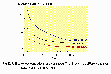
Hg concentrations of pikes (about 7 kg) in the three different basin of Lake Paijanne in 1970-1984.
- Supplementary notes
Use of Hg-based additives against slime has been forbidden since 1968 in paper mills.
- Nitrogen and phosphorus loadings to the lake [kg day-1]
| 1986 | |||||
| Sources | Industrial | Domestic | Agricultural | Natural | Total |
|---|---|---|---|---|---|
| T-N | 1,270 | 1,800 | ca. 600 | ca. 11,000 | ca. 15.000 |
| T-P | 135 | 40 | ca. 20 | ca. 300 | ca. 500 |
- Supplementary notes
Loadings have diminished after the 1960's due to wastewater purification and industrial (pulp mill) reconstruction.
- Extent of damage: None.
- Past trends in hydrogen ion concentration in lake and rain water
| 1973 | 1975 | 1977 | 1979 | 1981 | 1983 | 1985 | |
|---|---|---|---|---|---|---|---|
| Lake water | 6.6 | 6.6 | 6.7 | 6.6 | 6.6 | 6.6 | 6.6 |
| Rain water | - | 4.8 | 4.6 | 4.6 | 4.6 | 4.5 | 4.6 |
J. WASTEWATER TREATMENTS (Q)
J1 GENERATION OF POLLUTANTS IN THE CATCHMENT AREA-
c) Limited pollution with wastewater treatment.
| P[%] | N[%] | |
|---|---|---|
| - Non-point sources | 66 | 82 |
| - Point sources | (34) | (18) |
| Municipal | 7 | 10 |
| Industrial | 27 | 8 |
| - Total | 100 | 100 |
- Percentage of municipal population in the catchment area provided with
adequate sanitary facilities (on-site treatment systems) or public sewerage: ca. 100%. - Percentage of rural population with adequate sanitary facilities (on-site
treatment systems): ca. 80%. - Municipal wastewater treatment systems
No. of tertiary treatment systems: ca. 30 (activated sludge with simultaneous P-coagulation). - Industrial wastewater treatment systems
No.of industrial wastewater treatment systems: 4 (activated sludge, mechanical (+chemical)).
M. LEGISLATIVE AND INSTITUTIONAL MEASURES FOR UPGRADING LAKE ENVIRONMENTS (Q)
M3 RESEARCH INSTITUTES ENGAGED IN THE LAKE ENVIRONMENT STUDIES- University bf Jyvaskyla, Institute for Environmental Research
N. SOURCE OF DATA
- Questionnaire filled by Messrs. J. Niemi and A. Makela, National Board of Waters and Environment, Helsinki, Finland.
