LOCH NESS
A lake view with Urquhart castle
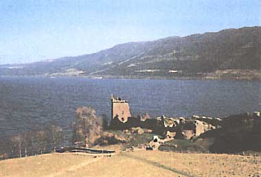
Photo: M. Kumagai
A. LOCATION
- Highland, UK.
- 57:15N, 4:30W; 15.8 m above sea level.
B. DESCRIPTION
Loch Ness is an extremely narrow and long lake, extending from the northeast to the southwest in the Inverness area of north Scotland. The lake is about 39 km long, but only 1.5 km wide, and has a maximum depth of 230 m and a mean depth of 132 m. Its water volume is the largest, and the surface area is the second largest next to Loch Lomond, in this country. The lake water flows out to Moray Firth through the Ness River. It is known as one of the most scenic lakes of this country, with an old ruined castle on the lakeside and surrounding mountain view. The lake is also so famous for the "Nessy", a world-famous unidentified organism. Investigations on Nessy have been carried out since 1962 by the Loch Ness Investigation, a voluntary organization with some scientists.
The drainage basin is still rich in woodlands and grasslands, having a low population density of 1.8 km-2. Nutrients inflow to the lake, therefore, is still in low level and the water remains oligotrophic and transparent. However, it is anxious that eutrophication may be caused by many tourists attracted by Nessy and by increasing activity of residents in the drainage basin.
C. PHYSICAL DIMENSIONS
| Surface area [km2] | 56 |
| Volume [km3] | 7.45 |
| Maximum depth [m] | 230 |
| Mean depth [m] | 132 |
| Water level | Regulated |
| Length of shoreline [km] | 86 |
| Residence time [yr] | 2.8 |
| Catchment area [km2] | 1,775 |
D. PHYSIOGRAPHIC FEATURES
D1 GEOGRAPHICAL
- Bathymetric ma: Fig. EUR-08-01.
- Names of main islands: None.
- Number of outflowing rivers and channels (name): 1 (Ness R.)(1).
D2 CLIMATIC
- Climatic data at Achnashellach*1 (3)*2
| Mean temp. [deg C] |
| Jan | Feb | Mar | Apr | May | Jun | Jul | Aug | Sep | Oct | Nov | Dec | Ann. |
|---|
| 2.8 | 3.2 | 5.2 | 6.9 | 10.1 | 12.4 | 13.8 | 13.6 | 11.6 | 8.7 | 5.7 | 4.1 | 8.2 |
| Precipitation [mm] |
| 232 | 177 | 127 | 156 | 93 | 114 | 148 | 150 | 189 | 234 | 196 | 242 | 2,058 |
| *1 Circa 50 km west of the lake. |
| *2 13-year mean. |
- Number of hours of bright sunshine: 1,374 hr yr-1 (3).
- Snowfall (lake side): 15-20 day yr-1 (2).
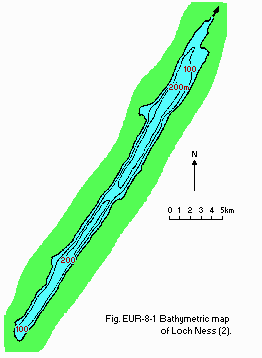
Fig. EUR-08-01
Bathymetric map (2).
- Water temperature [deg C](2)
| December 1977-November 1978 |
| Depth [m] | Jan | Feb | Mar | Apr | May | Jun | Jul | Aug | Sep | Oct | Nov | Dec |
|---|
| 0 | 5.7 | 5.6 | 5.6 | 6.3 | 7.5 | 10.0 | 12.5 | 13.5 | 12.5 | 10.6 | 9.8 | 8.0 |
| 75 | 5.7 | 5.6 | 5.6 | 6.3 | 5.8 | 6.6 | 7.5 | 6.3 | 6.5 | 6.7 | 7.3 | 8.0 |
- Freezing period: None.
- Notes on water mixing and thermocline formation
The thermocline is formed from May to October.
E. LAKE WATER QUALITY
E1 TRANSPARENCY [m](4)
November 1977-October 1978: 3.6-4.6.
E2 pH (4)
| November 1977-October 1978 |
| Depth [m] | Jan | Feb | Mar | Apr | May | Jun | Jul | Aug | Sep | Oct | Nov | Dec |
|---|
| 0-10 | - | 6.7 | 6.7 | - | 6.8 | - | 6.6 | 6.5 | - | 6.6 | - | 6.8 |
E6 CHLOROPHYLL CONCENTRATION [micro g l-1](5)
| November 1977-October 1978 |
| Depth [m] | Jan | Feb | Mar | Apr | May | Jun | Jul | Aug | Sep | Oct | Nov | Dec |
|---|
| 0-10 | - | 0.2 | 0.2 | - | 0.3 | - | 1.6 | 1.7 | - | 0.9 | - | 0.3 |
E7 NITROGEN CONCENTRATION (4)
| November 1977-October 1978 |
| Depth [m] | Jan | Feb | Mar | Apr | May | Jun | Jul | Aug | Sep | Oct | Nov | Dec |
|---|
| 0-10 | - | 0.12 | 0.10 | - | 0.09 | - | 0.09 | 0.09 | - | - | 0.14 | 0.13 |
E8 PHOSPHORUS CONCENTRATION (4)
- PO4-P [micro g l-1]
November 1977-October 1978: <10.
F. BIOLOGICAL FEATURES
F1 FLORA
- Emerged macrophytes (6)
Scutellaria galericum, Veronica scutellata, Carex rostrata, Menyanthes trifoliata, Mentha aquatica, Potentilla palustris.
- Submerged macrophytes: Myriophyllum alterniflorum (6).
- Phytoplankton (5)
Oscillatoria sp., Elakatothrix sp., Melosira sp., Rhizosolenia eriensis, Asterionella formosa, Tabellaria fenestrata, T. flocculosa.
F2 FAUNA
- Zooplankton (7)
Daphnia hyalina, Bosmina coregoni, Diaptomus gracilis, Cyclops abyssorum.
- Benthos (8, 9)
Lumbriculus variegatus, Cloeon simile, Amphinemura sulcicollis, Chloroperla torrentium, Sigara dosalis, Stylaria lacustris, Asellus aquaticus, Nemoura avicularis.
- Fish (10)
Lampetra planeri, Salmo salar, S. trutta, Salvelinus alpinus, Esox lucius, Anguilla anguilla, Gasterosteus aculeatus.
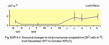
Fig. EUR-08-02
Seasonal changes in total crustacean zooplankton [1,000 cells m-3], November 1977-October 1978 (7).
G. SOCIO-ECONOMIC CONDITIONS (1)
G1 LAND USE IN THE CATCHMENT AREA
| Area [km2] | [%] |
|---|
| - Natural landscape |
| Woody vegetation | 247.9 | 14.3 |
| Rough | 1,354 | 78.3 |
| - Agricultural land | 32.6 | 1.9 |
| - Urban | 7.5 | 0.4 |
| - Others | 86.2 | 5.1 |
| - Total | 1,728.2 | 100.0 |
G3 POPULATION IN THE CATCHMENT AREA
|
| Population | Population density [km-2] | Major cities (population) |
|---|
| Total | 3,100 | 1.8 | Inverness |
J. WASTEWATER TREATMENTS
J1 GENERATION OF POLLUTANTS IN THE CATCHMENT AREA
b) No sources of significant pollution.
J3 SANITARY FACILITIES AND SEWERAGE
- Municipal wastewater treatment systems
No. of plants: 8.
N. SOURCES OF DATA
- Maitland, P. S. (1981) Introduction and catchment analysis. The Ecology of Scotland's Largest Lochs, Lomond, Awe, Ness, Morar and Shiel (ed. Maitland, P. S.), pp. 1-28. Dr. W. Junk Publishers, The Hague.
- Smith, I. R., Lyle, A. A. & Rosie, A. J. (1981) Comparative physical limnology. Ibid., pp. 29-66.
- Muller, M. J. (1982) Selected Climatic Data for a Global Set of Standard Stations for Vegetation Science. 306 pp. Dr. W. Junk Publishers, The Hague.
- Bailley-Watts, A. E. & Duncan, P. (1981) Chemical characterisation, a one-year comparative study. The Ecology of Scotland's Largest Lochs, Lomond, Awe, Ness, Morar and Shiel (see above), pp. 67-90.
- ---. (1981) The phytoplankton. Ibid., pp. 91-118.
- ---. (1981) A review of macrophyte studies. Ibid., pp. 119-134.
- Maitland, P. S., Smith, B. D. & Dennis, G. M. (1981) The crustacean zooplankton. Ibid., pp. 135-154.
- Smith, B. D., Maitland, P. S., Young, M. R. & Carr, M. J. (1981) Ibid., pp. 155-204.
- Smith, B. D., Cuttle, S. P. & Maitland, P. S. (1981) The profundal zoobenthos. Ibid., pp. 205-222.
- Maitland, P. S., Smith, B. D. & Adair, S. M. (1981) The fish and fisheries. Ibid., pp. 223-253.

