
NEUSIEDLERSEE
A bird-eye view from the north
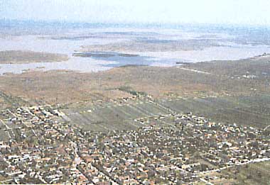
Photo: L. Beckel
A. LOCATION
- Burgenland, Austria; and Sopron, Hungary.
- 47:38-47:57N, 16:41-16:52E; 115.4 m above sea level.
B. DESCRIPTION
Neusiedlersee, the lake with the largest
surface area in Austria (320 km2), is situated on the Austrian-Hungarian
border with its southernmost part and its outflow in Hungary.
Thick stands of Phragmites communis occupy the littoral zone
of the lake which account for nearly 170 km2 swamp area (largest
marsh area of Central Europe). The lake is characterized by its
shallowness and high turbidity, caused by the erosion of silty
bottom material. The lake water has a mean conductivity (S) of
1,800 (under ice cover it can increase up to 3,000) with an average
ionic content of: Na+:Mg2+:Ca2+:K+ = 51:39:7:3 and HCO3-:SO42-:Cl-
= 24:10:18.
The lake occupies a tectonic depression
which came into existence only some 13,000 years B. P. at the
end of the Pleistocene. The lake has been extremely astatic throughout
its history with more than one hundred times of desiccation and
high water with the lake area almost twice its present surface.
Since the last desiccation in 1868, extensive pure growth of
P. communis have expanded mainly along its western and southern
shores constituting nearly 99% of the emergent macrophytes vegetation.
At present the lake is threatened with
eutrophication problems caused mainly by tourism and agriculture.
During the past two decades nutrient levels in the lake increased
steadily resulting in successive algal blooms. Since 1976 the
bloom species was Microcystis pulverea. Other man-made impacts
include the artificial regulation of lake water level, hunting
and poaching, introduction of exotic species and reclamation
of reed areas for agriculture and tourism.
Neusiedlersee was the site of an IBP project
during 1967-1972 and the succeeding IHD and MAB programs. In
1978 the Austrian part and in 1979 the Hungarian part of the
lake was declared as a biosphere reserve, thus establishing the
first international biosphere reserve. An up-to-date account
of the limnology of the lake is given by Loffler (1979)(Q, 1).
C. PHYSICAL DIMENSIONS (Q, 1)
| Surface area [km2] | 320 |
| Volume [km3] | 0.25 |
| Maximum depth [m] | 1.8 |
| Mean depth [m] | 0.8 |
| Water level | Regulated |
| Residence time [yr] | 3-4 |
| Catchment area [km2] | 1,300 |
D. PHYSIOGRAPHIC FEATURES
D1 GEOGRAPHICAL (Q)
- Sketch map: Fig. EUR-02-02.
- Bathymetric map: Fig. EUR-02-01.
- Names of main islands: Small reed islands.
- Number of outflowing rivers and channels (name): 1 (Einser Canal).
D2 CLIMATIC (Q)
- Climatic data near the lake, 1951-1983
| Mean temp. [deg C] | ||||||||||||
| Jan | Feb | Mar | Apr | May | Jun | Jul | Aug | Sep | Oct | Nov | Dec | Ann. |
|---|---|---|---|---|---|---|---|---|---|---|---|---|
| -1.5 | 0.4 | 4.4 | 10.5 | 14.6 | 18.5 | 20.0 | 19.4 | 15.9 | 10.6 | 5.3 | 0.7 | 9.9*1 |
| Precipitation [mm] | ||||||||||||
| Jan | Feb | Mar | Apr | May | Jun | Jul | Aug | Sep | Oct | Nov | Dec | Ann. |
| 34 | 33 | 42 | 54 | 59 | 80 | 69 | 65 | 40 | 48 | 51 | 42 | 617*2 |
- Number of hours of bright sunshine (1981-1983): 1,893 hr yr-1.
- Solar radiation (May-October, 1982 and 1983)*: 15.8 MJ m-2 day-1.
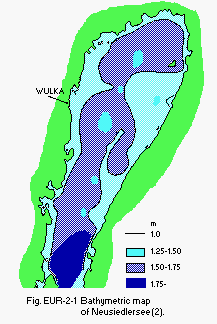
Fig. EUR-02-01
Bathymetric map (2).
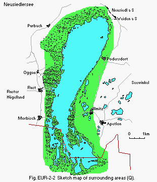
Fig. EUR-02-02
Sketch map of surrounding areas (Q).
- Water temperature [deg C]
Breitenbrunn
| Breitenbrunn | ||||||||||||
| Depth [m] | Jan | Feb | Mar | Apr | May | Jun | Jul | Aug | Sep | Oct | Nov | Dec |
|---|---|---|---|---|---|---|---|---|---|---|---|---|
| 2.7 | 1.6 | 5.8 | 11.2 | 17.1 | 19.6 | 23.4 | 20.7 | 16.1 | 11.2 | 3.8 | 1.9 | |
| Illmits | ||||||||||||
| 2.7 | 1.3 | 5.6 | 11.8 | 16.9 | 19.6 | 22.7 | 21.1 | 16.5 | 10.9 | 4.1 | 1.4 | |
- Freezing period: Late December-early March (54 days).
- Mixing type: Polymictic.
E. LAKE WATER QUALITY (Q)
E2 pH
| Station 1, 1977 | ||||||||||||
| Depth [m] | Jan | Feb | Mar | Apr | May | Jun | Jul | Aug | Sep | Oct | Nov | Dec |
|---|---|---|---|---|---|---|---|---|---|---|---|---|
| 8.6 | - | 8.7 | 8.6 | 8.8 | - | 8.9 | 8.7 | 8.7 | 8.8 | 8.5 | - | |
| Station 3, 1977 | ||||||||||||
| 8.7 | - | 8.7 | 8.7 | 8.8 | - | 8.9 | 8.8 | 8.9 | 8.8 | 8.7 | - | |
| Station 17, 1977 | ||||||||||||
| 8.6 | - | 8.6 | 8.5 | 8.6 | - | 8.8 | 8.7 | 8.9 | 8.6 | 8.7 | - | |
E3 SS [mg l-1]
| Station 1, 1977 | ||||||||||||
| Depth [m] | Jan | Feb | Mar | Apr | May | Jun | Jul | Aug | Sep | Oct | Nov | Dec |
|---|---|---|---|---|---|---|---|---|---|---|---|---|
| 2.3 | - | 7.5 | 46.1 | - | - | 83.5 | 66.1 | 57.2 | 58.6 | 24.1 | - | |
| Station 3, 1977 | ||||||||||||
| 13.3 | - | 30.0 | 35.3 | 57.4 | - | 132.2 | 48.5 | 134.5 | 171.3 | 39.4 | - | |
| Station 17, 1977 | ||||||||||||
| 5.2 | - | 20.6 | 13.2 | 107.0 | - | 42.1 | 20.9 | 39.5 | 28.1 | 11.6 | - | |
E4 DO [mg l-1]
| Bay, Neusiedl, 1968-1972 | ||||||||||||
| Depth [m] | Jan | Feb | Mar*1 | Apr | May*1 | Jun | Jul*2 | Aug*2 | Sep*2 | Oct*3 | Nov*3 | Dec |
|---|---|---|---|---|---|---|---|---|---|---|---|---|
| - | - | 15.8 | - | 10.8 | - | 9.4 | 9.5 | - | 6.7 | 10.9 | - | |
| *1 1972. *2 1971. *3 1968. | ||||||||||||
| Centre, Neusiedl, 1968-1972 | ||||||||||||
| - | - | 15.7 | - | 10.7 | - | - | 9.3 | - | - | - | - | |
| Reed, Neusiedl, 1968-1972 | ||||||||||||
| - | - | - | - | - | - | - | - | 4.9 | 4.5 | 5.63 | - | |
E5 COD [mg l-1]
No information.
E6 CHLOROPHYLL CONCENTRATION [micro g l-1]
| Station 1, 1977 | ||||||||||||
| Depth [m] | Jan | Feb | Mar | Apr | May | Jun | Jul | Aug | Sep | Oct | Nov | Dec |
|---|---|---|---|---|---|---|---|---|---|---|---|---|
| 12.0 | 19.7 | 24.5 | 15.3 | - | - | 8.7 | 7.6 | - | 5.5 | 1.1 | - | |
| Station 3, 1977 | ||||||||||||
| 14.2 | 24.0 | 22.3 | 13.1 | 7.5 | - | 14.2 | 6.6 | - | 9.8 | 7.6 | - | |
| Station 17, 1977 | ||||||||||||
| 19.1 | - | 13.8 | 6.6 | 12.2 | - | 10.9 | 2.2 | - | - | - | - | |
E7 NITROGEN CONCENTRATION
- NO3-N [mg l-1]
- NH4-N [mg l-1]
| Station 1, 1977 | ||||||||||||
| Depth [m] | Jan | Feb | Mar | Apr | May | Jun | Jul | Aug | Sep | Oct | Nov | Dec |
|---|---|---|---|---|---|---|---|---|---|---|---|---|
| 0.255 | - | 0.503 | 0.063 | 0.094 | - | 0.228 | 0.067 | 0.050 | 0.029 | - | - | |
| Station 3, 1977 | ||||||||||||
| 0.149 | - | 0.522 | 0.064 | 0.056 | - | 0.134 | 0.083 | 0.061 | 0.094 | - | - | |
| Station 17, 1977 | ||||||||||||
| 0.105 | - | 0.495 | 0.061 | 0.065 | - | 0.275 | 0.097 | 0.059 | 0.120 | - | - | |
| Station 1, 1977 | ||||||||||||
| Depth [m] | Jan | Feb | Mar | Apr | May | Jun | Jul | Aug | Sep | Oct | Nov | Dec |
|---|---|---|---|---|---|---|---|---|---|---|---|---|
| - | - | - | - | 0.033 | - | - | 0.021 | 0.027 | 0.014 | 0.020 | - | |
| Station 3, 1977 | ||||||||||||
| - | - | - | - | 0.033 | - | - | 0.019 | 0.067 | 0.021 | 0.022 | - | |
| Station 17, 1977 | ||||||||||||
| - | - | - | - | 0.035 | - | - | 0.025 | 0.042 | 0.118 | 0.016 | - | |
E8 PHOSPHORUS CONCENTRATION
- Total-P [mg l-1]
| Station 1, 1977 | ||||||||||||
| Depth [m] | Jan | Feb | Mar | Apr | May | Jun | Jul | Aug | Sep | Oct | Nov | Dec |
|---|---|---|---|---|---|---|---|---|---|---|---|---|
| 0.106 | - | 0.126 | 0.113 | - | - | 0.122 | 0.075 | 0.120 | 0.069 | 0.081 | - | |
| Station 3, 1977 | ||||||||||||
| 0.097 | - | 0.154 | 0.138 | 0.101 | - | 0.180 | 0.047 | 0.128 | 0.151 | 0.055 | - | |
| Station 17, 1977 | ||||||||||||
| 0.134 | - | 0.141 | 0.155 | 0.323 | - | 0.339 | 0.130 | 0.060 | 0.196 | 0.281 | - | |
E10 PAST TRENDS
No information.
F. BIOLOGICAL FEATURES (Q)
F1 FLORA- Emerged macrophytes
Phragmites australis (98%), Typha latifolia, Carex reparia. - Floating macrophytes
Lemna trisulca (reed belt), Utricularia vulgaris (reed belt). - Submerged macrophytes: Myriophyllum spicatum Potamogeton pectinatus.
- Phytoplankton
Microcystis pulverea, Monoraphidium contortum, Cyclotella meneghiniana.
F2 FAUNA
- Zooplankton
Arctodiaptomus sponosus, Keratella quadrata, Diphanosoma brachyurum, Leptodora kindti. - Benthos: Tanypus punctipennis, Procladius sp.
- Fish
Blicca bjorkna, Gymnocephalus cernua, Pelecus cultratus, Anguilla anguilla*, Stizostedion lucioperca*, Ctenopharyngodon idella*, Cyprinus carpio*. * Economically important.
F3 PRIMARY PRODUCTION RATE [g C m-2 yr-1]
| Neusiedl Gross production | ||||||||||||
| Jan | Feb | Mar | Apr | May | Jun | Jul | Aug | Sep | Oct | Nov | Dec | Ann.total |
|---|---|---|---|---|---|---|---|---|---|---|---|---|
| 11.4 | 9.8 | 102.3 | 56.5 | 85.1 | 188.9 | 180 | 188 | 218 | 53.4 | 9.1 | 30.3 | 86 |
F4 BIOMASS
No information.
F5 FISHERY PRODUCTS
- Annual fish catch [metric tons]
1985: 150. - Fishery products other than fish: None.
F6 PAST TRENDS:
No information.
F7 NOTES ON THE REMARKABLE CHANGES OF BIOTA IN THE LAKE IN RECENT YEARS
- Macrophytes
Submerged vegetation (Myriophyllum spicatum, Potamogeton pectinatus) was reduced. - Phytoplankton
Monoraphidium (Ankistrodesmus falcatus) dominated in the 1950's, thereafter decreased and reappeared in 1972. Then Oocystis lacustris, a new entry to the lake, appeared. Cyclotella cornuta became prevalent and Botryococcus braunii formed frequent blooms. Since 1976 frequent blooms of Microcystis pulverea have taken place. - Zooplankton
Moina rectirostris disappeared. Zooplankton increased and was dominated by rotifers in winter and spring. Leptodora kindti appeared in 1977. - Fish: Pelecus cultratus increased since mid 1970's.
G. SOCIO-ECONOMIC CONDITIONS (8, 1)
G1 LAND USE IN THE CATCHMENT AREA| Area [km2] | [%] | |
| - Natural landscape | ||
| Woody vegetation | 228.0 | 16.2 |
| Herbaceous vegetation | 148.7 | 10.6 |
| Swamp | 170 | 12.1 |
| Others | 343.3 | 24.4 |
| - Agricultural land | ||
| Crop field | 186.7 | 13.3 |
| Pasture land | 173.4 | 12.3 |
| Vine yard | 156.9 | 11.2 |
| - Total | 1,407 | 100 |
- Levels of fertilizer application on crop fields: Heavy.
- Trends of change in land use in recent years
Area covered by vineyards increased during the 1970's.
G2 INDUSTRIES IN THE CATCHMENT AREA AND THE LAKE
No information.
G3 POPULATION IN THE CATCHMENT AREA
No information.
H. LAKE UTILIZATION (8, 1 )
H1 LAKE UTILIZATION- Sightseeing and tourism (no. of visitors (overnight stay) in 1980: 2,000,000), recreation (sport-fishing, yachting) and fisheries.
H2 THE LAKE AS WATER RESOURCE:
No information.
I. DETERIORATION OF LAKE ENVIRONMENTS AND HAZARDS (Q)
I1 ENHANCED SILTATION- Extent of damage: Serious.
I2 TOXIC CONTAMINATION
- Present status: No information.
I3 EUTROPHICATION
- Nuisance caused by eutrophication
Unusual algal bloom (Microcystis pulverea). - Nitrogen and phosphorus loadings to the lake [t yr-1]
1984
| Sources | Industrial | Domestic | Agricultural | Natural | Total |
|---|---|---|---|---|---|
| T-P | - | 54 | 72 | 18 | 144 |
I4 ACIDIFICATION: No information.
J. WASTEWATER TREATMENTS (Q)
J1 GENERATION OF POLLUTANTS IN THE CATCHMENT AREAd) Measurable pollution with limited wastewater treatment.
J3 SANITARY FACILITIES AND SEWERAGE
- Percentage of municipal population in the catchment area provided with adequate sanitary facilities (on-site treatment systems) or public sewerage: 100%.
- Percentage of rural population with adequate sanitary facilities (on-site treatment systems): 100%.
- Municipal wastewater treatment systems: 25%.
K. IMPROVEMENT WORKS IN THE LAKE
No information.
L. DEVELOPMENT PLANS
No information.
M. LEGISLATIVE AND INSTITUTIONAL MEASURES FOR UPGRADING LAKE ENVIRONMENTS (Q)
M1 NATIONAL AND LOCAL LAWS CONCERNED:No information.
M2 INSTITUTIONAL MEASURES:
No information.
M3 RESEARCH INSTITUTES ENGAGED IN THE LAKE ENVIRONMENT STUDIES
- Department of Limnology, Institute of Zoology, University of Vienna
- Biological Station, Illmitz
N. SOURCES OF DATA
- Questionnaire filled by Prof. H. Loffler, Zoologisches Institut, Universitat Wien, Austria.
- Loffler, H. (ed.)(1979) Neusiedlersee-Limnology of a Shallow Lake in Central Europe. Dr. W. Junk Publisher, The Hague.
- Atlas, AN 6014.
