
HARVEYS LAKE
A view on the lakeshore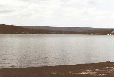
Photo: Department of Environment Resources, Pennsylvania
A. LOCATION
- Luzerne County and Pennsylvania, USA.
- 41:21-41:24N, 76:02-76:04W; 382.5 m above sea level.
B. DESCRIPTION
-
Harveys Lake is situated 17.7 km northwest of Wilkes-Barre, Lake Township, Luzerne County. It is a high quality glacial lake that should be protected against any degradation. The lake has three inflows of minor importance, while groundwater supplies most of the water to the lake basin.
A lake-wide toxic blue-green algae bloom which occurred during the summer of 1981 in Harveys Lake, required the imposition of a warning by the Bureau of Water Quality Management against water contact activities. This warning effectively closed the lake, especially as plankton counts rose and it became obvious to the casual observer that an extensive bloom existed. Bloom concentrations (greater than 500 cells ml-1) were measured in late July and continued until mid-September with counts of blue-greens as high as 3,375 cells ml-1 in mid-August.
A lake monitoring program was instituted in April 1982 in response to what appeared to be a deterioration of the trophic state of the lake, which was determined to be mesotrophic in 1981. Equipment and technical assistance were provided by the Bureau of Water Quality Management and the Bureau of Laboratories to the Harveys Lake Water Quality Management Board, which carried out the majority of the field work.
Harveys Lake should be protected from degradation by diversion of domestic wastes from the basin (Q, 2).
C. PHYSICAL DIMENSIONS
| Surface area [km2] | 2.66 |
| Volume [km3] | 0.0294 |
| Maximum depth [m] | 29.3 |
| Mean depth [m] | 11 |
| Length of shoreline [km] | 13.4 |
| Residence time [yr] | 3.06 |
| Catchment area [km2] | 14.7 |
D. PHYSIOGRAPHIC FEATURES
D1 GEOGRAPHICAL- Bathymetric map: Fig. NAM-61-1.
- Number of outflowing rivers and channels (name): 1 (Harveys Creek).
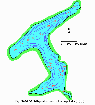
Bathymetric map [m](3).
D2 CLIMATIC
- Climatic data at Harrisburg*, 1931 1960 (1)
| Jan | Feb | Mar | Apr | May | Jun | Jul | Aug | Sep | Oct | Nov | Dec | Ann. | |
|---|---|---|---|---|---|---|---|---|---|---|---|---|---|
| Mean temp. [deg C] | -0.1 | 0.3 | 4.6 | 11.0 | 17.1 | 21.8 | 24.3 | 23.1 | 19.1 | 13.2 | 6.6 | 0.8 | 11.8 |
| Precipitation [mm] | 70 | 59 | 87 | 77 | 99 | 87 | 89 | 93 | 72 | 75 | 75 | 74 | 957 |
- Number of hours of bright sunshine: 643 hr yr-1.
- Water temperature [deg C]
| North basin, 1980 | ||||||||||||
| Depth [m] | Jan | Feb | Mar | Apr | May | Jun | Jul | Aug | Sep | Oct | Nov | Dec |
|---|---|---|---|---|---|---|---|---|---|---|---|---|
| 1 | - | - | - | - | 13.2 | - | 24.5 | - | 23.9 | - | - | - |
| 25 | - | - | - | - | 6.9 | - | - | - | - | - | - | - |
| 27 | - | - | - | - | - | - | 7.0 | - | 7.0 | - | - | - |
E. LAKE WATER QUALITY
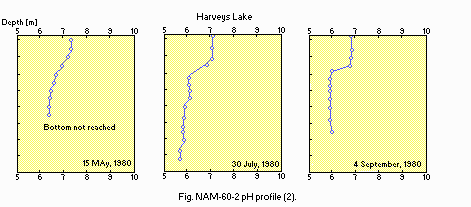
E1 TRANSPARENCY (2)| North basin, 1980 | |||||||||||
| Jan | Feb | Mar | Apr | May | Jun | Jul | Aug | Sep | Oct | Nov | Dec |
|---|---|---|---|---|---|---|---|---|---|---|---|
| - | - | - | - | 3.66 | - | 4.43 | - | 4.17 | - | - | - |
| North basin, 1980 | ||||||||||||
| Depth [m] | Jan | Feb | Mar | Apr | May | Jun | Jul | Aug | Sep | Oct | Nov | Dec |
|---|---|---|---|---|---|---|---|---|---|---|---|---|
| 1 | - | - | - | - | 7.3 | - | 7.1 | - | 6.9 | - | - | - |
| 25 | - | - | - | - | 6.4 | - | - | - | - | - | - | - |
| 27 | - | - | - | - | - | 5.8 | - | - | 6.1 | - | - | - |
E4 DO [mg l-1](2)
| North basin, 1980 | ||||||||||||
| Depth [m] | Jan | Feb | Mar | Apr | May | Jun | Jul | Aug | Sep | Oct | Nov | Dec |
|---|---|---|---|---|---|---|---|---|---|---|---|---|
| 1 | - | - | - | - | 10.9 | - | 9.0 | - | - | - | - | - |
| 25 | - | - | - | - | 10.1 | - | - | - | - | - | - | - |
| 27 | - | - | - | - | - | - | 3.7 | - | - | - | - | - |
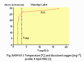
Temperature [deg C] and dissolved oxygen [mg l-1] profile, 4 April 1982 (3).
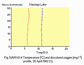
Temperature [deg C] and dissolved oxygen [mg l-1] profile, 28 April 1982 (3).
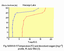
Temperature [deg C] and dissolved oxygen [mg l-1] profile, 15 June 1982 (3).
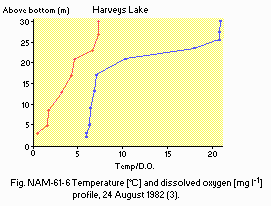
Temperature [deg C] and dissolved oxygen [mg l-1] profile, 24 August 1982 (3).
E6 CHLOROPHYLL CONCENTRATION [micro l-1](2)
| North basin, 1980 | ||||||||||||
| Depth [m] | Jan | Feb | Mar | Apr | May | Jun | Jul | Aug | Sep | Oct | Nov | Dec |
|---|---|---|---|---|---|---|---|---|---|---|---|---|
| 1 | - | - | - | - | 5.17 | - | - | 5.03 | - | 2.95 | - | - |
- Total-N [mg l-1]
| North basin, 1980 | ||||||||||||
| Depth [m] | Jan | Feb | Mar | Apr | May | Jun | Jul | Aug | Sep | Oct | Nov | Dec |
|---|---|---|---|---|---|---|---|---|---|---|---|---|
| 1 | - | - | - | - | 0.32 | - | 0.22 | - | 0.22 | - | - | - |
| 25 | - | - | - | - | 0.17 | - | - | - | - | - | - | - |
| 27 | - | - | - | - | - | - | 0.36 | - | 0.41 | - | - | - |
- Total-P [mg l-1]
| North basin, 1980 | ||||||||||||
| Depth [m] | Jan | Feb | Mar | Apr | May | Jun | Jul | Aug | Sep | Oct | Nov | Dec |
|---|---|---|---|---|---|---|---|---|---|---|---|---|
| 1 | - | - | - | 0.02 | - | - | 0.01 | - | 0.04 | - | - | - |
| 25 | - | - | - | 0.02 | - | - | - | - | - | - | - | - |
| 27 | - | - | - | - | - | - | 0.01 | - | 0.05 | - | - | - |
F. BIOLOGICAL FEATURES
F1 FLORA (2, 3)- Emerged macrophytes
Shoreline covered by plants: 1 3%. Nuphar advena. - Floating macrophytes
Lake surface covered by plants: 1 3%. Brasenia schreberi, Nymphaea odorata. - Submerged macrophytes
Lake bottom covered by submerged plants: 1 3%. Potamogeton amplifolius, Cabomba caroliniana, Myriophyllum exalbescens. - Phytoplankton (1980, 1982)
Asterionella, Fragilaria, Synedra, Dinobryon (spring), Anabaena, Fragilaria, Asterionella, Synedra, Cryptomonas, Scenedesmus, Gloeocystis (summer).
- Fish
- Supplementary notes
The lake lacks shoal areas, fertility and temperature to support a productive warm water fishery. Lake trout (Salvelinus namaycush) have shown signs of success. The lake is recommended for trout stocking.
Salmo gairdneri, Salvelinus namaycush, Micropterus salmoides, Lepomis macrochirus, L. gibbosus, Ambloplites rupestris, Pomoxis nigromaculatus, Esox niger, Perca flavescens, Catostomus commersoni, Ictalurus nebulosus, I. natalis, Osmerus mordax.
- Decrease in smelt (Osmerus) population. Large alewife population die off.
G. SOCIO-ECONOMIC CONDITIONS
G1 LAND USE IN THE CATCHMENT AREA (2) (1980)| Area [km2] | [%] | |
|---|---|---|
| Natural landscape | 11.17 | 76 |
| Agricultural land | 0.15 | 1 |
| Residential area | 3.38 | 23 |
| Total | 14.7* | 100 |
| Population | Population density [km 2] | Major cities | |
|---|---|---|---|
| Total | 2,318 | 158 | Harveys Lake Borough |
H. LAKE UTILIZATION
H1 LAKE UTILIZATION (2)- Recreation (swimming, sport-fishing).
I. DETERIORATION OF LAKE ENVIRONMENTS AND HAZARDS
I2 TOXIC CONTAMINATION (2) (1980)- Main contaminants, their concentrations and sources
| Name of contaminant | Concentration in sediment [micro kg 1] |
|---|---|
| DDE | 2.7 |
| PCB | 34.0 |
- Nuisance caused by eutrophication
Unusual algal bloom (Anabaena spp.). - Supplementary notes
In 1981, the lake experienced heavy bloom of blue-green algae (Anabaena spp.) and was closed for recreation. In 1984 bloom conditions occurred once again and copper sulphate was applied. Control was achieved. No major bloom have occurred since then.
- Extent of damage: None.
J. WASTEWATER TREATMENTS (Q)
J1 GENERATION OF POLLUTANTS IN THE CATCHMENT AREA- (d) Measurable pollution with limited wastewater treatment.
- Percentage of municipal population in the catchment area provided with
adequate sanitary facilities or public sewerage: 100%. - Supplementary notes
Sewage treatment plants are mostly out of the lake's basin.
N. SOURCES OF DATA
- Questionnaire filled by the editors with the support of Pennsylvania Department of Environmental Resources, Bureau of Water Quality Management, based on the following sources.
- Court, A. (1974) The climate of the conterminous United States. "World Surveys of Climatology, Volume 11, Climate of North America" (ed. Bryson, R. A. & Hare, F. K.), p. 322. Elsevier Scientific Publishing Company, Amsterdam-London-New York.
- Ulanoski, J. T., Shertzer, R. H., Barker, J. L. & Hartman, R. T. (1981) Trophic Classification and Characteristics of Twenty-six Publicity Owned Pennnsylvania Lakes. Bul. No. 61, Bureau of Water Management, Pennsylvania Department of Environmental Resources. 240 pp.
- Kupsky, E. P. (1982) Harveys Lake - Final Report 1982. Department of Environmental Resources, Bureau of Water Quality Management, Wilkes -Barre Regional Office. (Manuscript).
