LAKE DIEFENBAKER
An aerial view of outlet structures at lower end of the lake
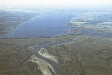
Photo: Prairie Farm Rehabilitation, Regina
A. LOCATION
- Saskatchewan, Canada.
- 50:40-51:20N, 106:30-108:15W; 556.8* m above sea level.
* Full supply level.
B. DESCRIPTION
Lake Diefenbaker is a large multi-purpose reservoir on the South Saskatchewan River in southern Saskatchewan. The reservoir was developed as a joint undertaking by the Canadian and Saskatchewan governments to provide for a wide range of uses including power production, flood control, irrigation, industrial water supply, recreation and augmentation of flows in the Qu'Applelle River by diversion through the Qu'Appelle Dam. The structures were designed and constructed by the Prairie Farm Rehabilitation Administration. Construction began in 1958 and the reservoir was filled in 1967.
Inflow to Lake Diefenbaker is primarily from the South Saskatchewan River which originates as the Oldman, Bow and Red Deer Rivers in the mountains of southwestern Alberta. These rivers drain much of southern Alberta which, except for the mountain regions, is mainly treeless prairie used for grain and livestock production. Approximately 75% of the drainage to Lake Diefenbaker is in Alberta. The quality of water entering Lake Diefenbaker is generally very good and the lake represents a major source of high quality water in an area where water quality on other water bodies is generally poor, usually with high levels of minerals and nutrients. As a result a number of projects to draw drinking water for communities in southern Saskatchewan, including Regina and Moose Jaw, have been and are being examined.
The South Saskatchewan River traversed the sandy soils of the Missouri Coteau where Lake Diefenbaker is now situated and the valley is a deep, broad, strongly eroded meltwater channel cut 60 to 150 meters into the glacial deposits and underlying bedrock. In the upper reaches of the lake the deep valley is still evident. The recreational potential of the lake is significant, providing a healthy sport fishery, large sandy beaches and excellent boating. There are a number of cottage developments along its shores and three provincial parks (Q).
C. PHYSICAL DIMENSIONS (1)
| Surface area [km2] | 430 |
| Volume [km3] | 9.4 |
| Maximum depth [m] | 66 |
| Mean depth [m] | 21.6 |
| Water level | Regulated |
| Normal range of annual water level fluctuation [m] | 7.5 |
| Length of shoreline [km] | 760 |
| Residence time [yr] | 2.5 |
| Catchment area [km2] | 135,500 |
D. PHYSIOGRAPHIC FEATURES
D1 GEOGRAPHICAL (1)
- Sketch map: Fig. NAM-58-01.
- Names of main islands: None.
- Number of outflowing rivers and channels (name)
3 (South Saskatchewan Qu'Appelle River Diversion and Saskatoon S.E. Water Supply System).
D2 CLIMATIC
- Climatic data at Outlook*, 1951-1980 (2)
| Jan | Feb | Mar | Apr | May | Jun | Jul | Aug | Sep | Oct | Nov | Dec | Ann. |
| Mean temp. [deg C] | -12.3 | -6.9 | -1.9 | 9.8 | 18.8 | 22.9 | 26.4 | 25.8 | 18.9 | 11.9 | 0.5 | -7.1 | 8.9 |
| Precipitation [mm] | 15 | 13 | 17 | 17 | 28 | 65 | 53 | 37 | 32 | 15 | 9 | 14 | 315 |
* Circa 25 km north of Gardiner Dam, the outlet of the lake.
- Number of hours of bright sunshine (Swift Current*): 2,330 hr yr-1.
* Circa 40 km south of the west (upstream) end of the lake.
- Solar radiation [MJ m-2 day-1]
| Jan | Feb | Mar | Apr | May | Jun | Jul | Aug | Sep | Oct | Nov | Dec | Ann. |
| 5.05 | 8.72 | 14.1 | 17.9 | 21.6 | 23.1 | 24.4 | 20.1 | 14.4 | 9.45 | 5.27 | 3.83 | 13.9 |
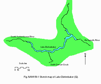
Fig. NAM-58-01
Sketch map of the lake (Q).
- Water temperature [deg C](1)
Riverhurst Ferry Crossing, 1984-1985
| Depth [m] | Jan | Feb | Mar | Apr | May | Jun | Jul | Aug | Sep | Oct | Nov | Dec |
| 0 | 2 | 2 | 2 | - | 6 | 8 | 18 | 22 | 16 | 12 | - | - |
| 5 | 2 | 2 | 2 | - | 6 | 8 | 18 | 20 | 16 | 12 | - | - |
| 10 | 2 | 2 | 2 | - | 6 | 8 | 18 | 20 | 16 | 12 | - | - |
| 15 | 2 | 2 | 2 | - | 6 | 8 | 18 | 18 | 16 | 12 | - | - |
| 20 | 2 | 2 | 2 | - | 6 | 8 | 16 | 16 | 16 | 12 | - | - |
| 25 | 2 | 2 | 2 | - | 6 | 8 | 14 | 14 | 14 | 12 | - | - |
| 30 | 2 | 2 | 2 | - | 6 | 8 | 14 | 12 | 12 | 12 | - | - |
| 35 | 2 | 2 | 2 | - | 6 | 8 | 14 | 12 | 12 | 12 | - | - |
- Freezing period: 1 December-20 April.
- Mixing type: Polymictic.
- Notes on water mixing and thermocline formation
Thermocline develops in the deeper areas of the lake for varying lengths of time during summer months.
E. LAKE WATER QUALITY
E1 TRANSPARENCY [m](1)
| Riverhurst Ferry*, 1984-1985 |
| Jan | Feb | Mar | Apr | May | Jun | Jul | Aug | Sep | Oct | Nov | Dec |
| - | - | - | - | 2.2 | 2.0 | 3.1 | 6.5 | 6.5 | 4.6 | - | - |
* Circa the middle point of the lake.
E2 pH
| Riverhurst Ferry, 1984-1985 |
| Depth [m] | Jan | Feb | Mar | Apr | May | Jun | Jul | Aug | Sep | Oct | Nov | Dec |
| 0-35 | - | 8.5 | 8.5 | - | 8.6 | 8.5 | 8.6 | 8.4 | 8.3 | 8.5 | - | - |
E3 SS [mg l-1](1)
| Riverhurst Ferry*, 1984-1985 |
| Depth [m] | Jan | Feb | Mar | Apr | May | Jun | Jul | Aug | Sep | Oct | Nov | Dec |
| 0-35 | - | 1 | 3 | - | 5 | 4 | 4 | 1 | 3 | 4 | - | - |
* Particulate matter or non-filterable residue.
E4 DO [mg l-1](1)
| Riverhurst Ferry, 1984-1985 |
| Depth [m] | Jan | Feb | Mar | Apr | May | Jun | Jul | Aug | Sep | Oct | Nov | Dec |
| 0 | - | 12.1 | 11.0 | - | 10.1 | - | 9.2 | 8.6 | 9.1 | 9.1 | - | - |
| 5 | - | 12.0 | 11.1 | - | 10.1 | - | 9.4 | 8.6 | 9.2 | 9.0 | - | - |
| 10 | - | 12.0 | 11.0 | - | 10.1 | - | 9.1 | 8.0 | 9.0 | 9.2 | - | - |
| 15 | - | 12.1 | 11.0 | - | 9.0 | - | 8.6 | 8.2 | 8.9 | 9.1 | - | - |
| 20 | - | 10.8 | 11.0 | - | 10.0 | - | 8.4 | 8.1 | 7.8 | 9.0 | - | - |
| 25 | - | 10.1 | 10.1 | - | 10.1 | - | 8.7 | 6.1 | 5.9 | 9.0 | - | - |
| 30 | - | 8.4 | 8.6 | - | 10.1 | - | 8.5 | 4.5 | 4.4 | 9.1 | - | - |
| 35 | - | 6.9 | 7.4 | - | 10.0 | - | 8.5 | 2.7 | 3.1 | 9.0 | - | - |
E6 CHLOROPHYLL CONCENTRATION [micro l-1](1)
| Riverhurst Ferry, 1984-1985 |
| Depth [m] | Jan | Feb | Mar | Apr | May | Jun | Jul | Aug | Sep | Oct | Nov | Dec |
| * | 1 | 1 | 1 | - | - | 5 | 2 | 3 | 1 | 1 | - | - |
* Integrated over 2 x photic zone.
| Danielson*, 1984-1985 |
| 1984 | | 1985 |
| Depth [m] | Summer | Fall | Winter | Spring | Mean |
| <1 | 1 | 1 | 3 | 2 |
* Downstream end.
| Riverhurst Ferry*, 1984-1985 |
| 1984 | | 1985 |
| Depth [m] | Summer | Fall | Winter | Spring | Mean |
| 2 | 1 | 1 | 5 | 2 |
* Middle point.
| Sask. Landing*, 1984-1985 |
| 1984 | | 1985 |
| Depth [m] | Summer | Fall | Winter | Spring | Mean |
| 6 | 7 | 1 | 12 | 6 |
* Upstream end.
E7 NITROGEN CONCENTRATION [mg l-1](1)
| Riverhurst Ferry, 1984-1985 |
| Depth [m] | Jan | Feb | Mar | Apr | May | Jun | Jul | Aug | Sep | Oct | Nov | Dec |
| * | 0.25 | 0.20 | 0.51 | - | 0.23 | 0.34 | 0.25 | 0.25 | 0.20 | 0.19 | - | - |
* Integrated over 0-35 m.
| Danielson, 1984-1985 |
| 1984 | | 1985 |
| Depth [m] | Summer | Fall | Winter | Spring | Mean |
| 0.38 | - | 0.45 | 0.70 | 0.46 |
| Riverhurst Ferry, 1984-1985 |
| 1984 | | 1985 |
| Depth [m] | Summer | Fall | Winter | Spring | Mean |
| 0.47 | 0.54 | 0.54 | 0.51 | 0.52 |
| Sask. Landing, 1984-1985 |
| 1984 | | 1985 |
| Depth [m] | Summer | Fall | Winter | Spring | Mean |
| 0.77 | 0.74 | 0.99 | 0.63 | 0.81 |
E8 PHOSPHORUS CONCENTRATION (1)
| Riverhurst Ferry, 1984-1985 |
| Depth [m] | Jan | Feb | Mar | Apr | May | Jun | Jul | Aug | Sep | Oct | Nov | Dec |
| * | 12 | 12 | 15 | - | 9 | 8 | 20 | 8 | 30 | 8 | - | - |
* Integrated over 0-35 m.
| Danielson, 1984-1985 |
| 1984 | | 1985 |
| Depth [m] | Summer | Fall | Winter | Spring | Mean |
| 12 | 11 | 9 | 11 | 11 |
| Riverhurst Ferry, 1984-1985 |
| 1984 | | 1985 |
| Depth [m] | Summer | Fall | Winter | Spring | Mean |
| 14 | 20 | 11 | 12 | 14 |
| Sask. Landing, 1984-1985 |
| 1984 | | 1985 |
| Depth [m] | Summer | Fall | Winter | Spring | Mean |
| 49 | 30 | 31 | 35 | 39 |
F. BIOLOGICAL FEATURES
F1 FLORA
- Phytoplankton (1)
Chlorophyta
Actinastrum gracilimum, Ankistrodesmus falcatus, Chlamydomonas sp., Cladophora fracta, Closterium sp., Coelastrum cambricum, C. microporum, Cosmarium sp., Crucigenia apiculata. C. quadrata. C. tetrapedia, Dictyosphaerium pulchellum, D. simplex, Elaktothrix gelatinosa, Eudorina elegans, Gonium pectorale, G. sociale, Kirchneriella lunaris, K. obesa, Lagerheimia quadriseta, L. subsalsa, Monoraphidium contortum, Oocystis borgei, O. gigas, O. solitaria, Pandorina morum, Pediastrum boryanum, P. duplex, P. obtusum, P. simplex. p. tetras, Quadrigula chodatii, Scenedesmus acuminatus, S. arcuatus, S. bijuga, S. ecornis, S. quadricauda, Selenastrum sp., S. bibraianum, S. gracile, Spirogyra weberi, Staurastrum sp.
Cyanophyta
Anabaena flos-aquae, A. spiroides, Aphanizomenon flos-aquae, Aphanocapsa sp., Aphahanothece sp., Chroococcus dispersus, C. limneticus, Coelosphaerium kuetzingianum, C. naegelianum, Gloeocapsa sp., Gomphosphaeria sp., G. aponina, Marssoniella elegans, Merismopedia elegans, M. glauca, Microcystis sp., M. aeruginosa, M. flos-aquae, Oscillatoria tenuis, Spirulina sp.
Bacillariophyta
Asterionella formosa, Centronella sp., Cocconeis pediculus, Cymatopeura sp., Cymbella sp., C. elongatum, Fragilaria crotonensis, Gomphonema sp., Gyrosigma sp., Melosira granulata, Meridion circulare, Navicula sp., Nitzschia sp., N. acicularis, N. linearis, Phoicosphenia curvata, Phopalodia gibba, Stephanodiscus astrea, Surirella sp., S. ovalis, S. ovata, Synedra sp., S. acus, S. ulna, Tabellaria fenestrata, Tropidoneis sp.
Chrysophyta
Dinobryon sertularia, D. sociale, Mallomonas sp., M. acardoides, Synura uvella, Tribonema utriculosum.
Euglenophyta: Euglena sp., Phacus sp., Trachelomonas., sp., T. robusta. Pyrrophyta
Ceratium hirundinella, Cryptomonas sp., Gymnodinium sp., Peridinium sp., P. cinctum, Rhodomonas sp.
F2 FAUNA
- Fish (3)
Esox masquinongy (northern pike), Stizostedion canadense (sauger), S. vitreum* (walleye), Hiodon alosoides (goldeye), Coregonus clupeaformis* (lake whitefish).
* Economically important; whitefish for commercial fishery and walleys for sport-fishing.
F5 FISHERY PRODUCTS
- Annual fish catch [metric tons]
1978: 91.
- Fishery products other than fish
4.1 tons of whitefish roe.
G. SOCIO-ECONOMIC CONDITIONS
G1 LAND USE IN THE CATCHMENT AREA (1976)
| Area [km2] | [%] |
| Natural landscape | 30,200 | 20.1 |
| Agricultural land |
| - Crop field | 76,800 | 51.2 |
| - Pasture land (improved) | 6,000 | 4.0 |
| Others | N.A. |
| Total | 150,000* | 100 |
* Includes additional ca. 13,000 km2 of entire South Saskatchewan River basin.
- Main kinds of crops and/or cropping systems: Wheat, mixed grains, hay.
- Levels of fertilizer application on crop fields: Moderate.
G2 INDUSTRIES IN THE CATCHMENT AREA AND THE LAKE (4,5) (1976)
| No.of persons engaged | No. of establishment | Main products or major industries |
| Primary industry | >90,000 | 25,700 | Grains, cattle, whitefish |
| Secondary industry | 29,700 | | Transportation, equipment, printing, wood products, metal fabrication, food & beverage |
- Numbers of domestic animals in the catchment area
Cattle 2,330,000, sheep 115,000, swine 427,000, poultry 4,330,000, horses 45,000.
G3 POPULATION IN THE CATCHMENT AREA (5) (1976)
| Population | Population density [km-2] | Major cities (population) |
| Urban | 545 | | Calgary, Medicine Hat, Lethbridge, Red Deer |
| Rural | 300 |
| Total | 845 | 6.2 |
H. LAKE UTILIZATION
H1 LAKE UTILIZATION
Source of water, navigation and transportation (ferry operation at Riverhurst), sightseeing and tourism, recreation (swimming, sport-fishing, yachting) and fisheries.
H2 THE LAKE AS WATER RESOURCES (6) (1985)
| Use rate [mill. t yr-1] |
| Domestic | 1 |
| Irrigation | 110 |
| Industrial | 6 |
| Power plant (downstream) | 1,340 |
| Others |
| - Diversion to Qu'Appelle R. | 142 |
| - SSEWS Project | 50 |
I. DETERIORATION OF LAKE ENVIRONMENTS AND HAZARDS
I1 ENHANCED SILTATION
- Extent of damage: Not serious.
I2 TOXIC CONTAMINATION
- Present status: Detected but not serious.
- Main contaminants, their concentrations and sources
| Saskatchewan Landing (7,8) |
| Name of contaminant | Concentration [ppm] in | Main source |
| Water*1 | Fish*2 |
| (1985) | (1970-1985) |
| 2, 4-D | <.05-.10 | - | Agrochemical |
| Lindane | <.002-.010 | - | Agrochemical |
| Mercury | - | 0.23-1.57 | Industrial & natural |
*1 Volume basis [g l-1].
*2 Muscle tissue of walleye, northern pike and goldeye [mg kg-1] on wet weight basis.
- Food safety standards or tolerance limits for toxic contaminant residue
0.5 mg kg-1 Hg in fish for human consumption.
- Past trends
Hg concentrations in fish tend to be declining. Sources of mercury believed to be a chlor-alkali plant in Saskatoon (downstream of Lake Diefenbaker) which no longer discharges Hg and is isolated from Lake Diefenbaker by Gardiner Dam and release of Hg from natural soil following filling of reservoir (9). Some of the fish with high mercury levels collected in Lake Diefenbaker, particularly in the 1970's, may have migrated from downstream of Saskatoon and been caught behind Gardiner Dam when it was closed.
I3 EUTROPHICATION
- Nitrogen and phosphorus loadings to the lake [t yr-1](1)
| 1975-1985 (mean) |
| Sources | Total |
| T-N | - |
| T-P | 1,230 |
- Supplementary notes
Examination of 1984-1985 phosphorus and chlorophyll a data using OECD model suggests that the upper end of the lake is mesotrophic or eutrophic while the remainder of the lake is mesotrophic or oligotrophic.
I4 ACIDIFICATION
J. WASTEWATER TREATMENTS
J1 GENERATION OF POLLUTANTS IN THE CATCHMENT AREA
(d) Measurable pollution with limited wastewater treatment.
J3 SANITARY FACILITIES AND SEWERAGE
- Percentage of municipal population in the catchment area provided with
adequate sanitary facilities (on-site treatment systems) or public sewerage: 100% (5).
- Municipal wastewater treatment systems
No. of tertiary treatment systems: 1 (Calgary, chemical removal of phosphorus).
No. of secondary treatment systems: 47 (lagoon systems).
M. LEGISLATIVE AND INSTITUTIONAL MEASURES FOR UPGRADING LAKE ENVIRONMENTS
M1 NATIONAL AND LOCAL LAWS CONCERNED
- Names of the laws (the year of legislation)
- Water Resources Management Act (1972)
- Water Rights Act (1970)
- South Saskatchewan River Irrigation Act (1960)
- Pollution (by livestock) Control Act (1971)
- Prairie Provinces Water Board Master Agreement on Apportionment (1969)
- Responsible authorities
- Saskatchewan Environment and Saskatchewan Water Corporation
- Saskatchewan Water Corporation
- Saskatchewan Water Corporation
- Saskatchewan Environment
- Prairie Provinces Water Board
- Main items of control
- Water pollution
- Water supply
- Diversion of water for irrigation
- Waste pollution from livestock operations
- Water apportionment between provinces
M2 INSTITUTIONAL MEASURES (the year of establishment)
- Saskatchewan Environment, Regina, Sask (1972)
- Saskatchewan Water Corporation, Moose Jaw, Sask
- South Saskatchewan River Basin Study Board, Moose Jaw, Sask (1986)
N. SOURCES OF DATA
- Questionnaire filled by Dr. D. Munro, Water Quality Branch, Western and Northern Region Conservation and Protection, Environment Canada, Saskatchewan, Canada.
- Water Quality Branch Saskatchewan Environment and Public Safety & Water Quality Branch, Environment Canada (1988) Lake Diefenbaker and Upper South Saskatchewan River, Water Quality Study, 1984-1985. Regina, Saskatchewan.
- Atmospheric Environment Service, Environment Canada (1982) Canadian Climate Normals, 1951-1980, Prairie Provinces. Winnipeg, Manitoba.
- Prairie Provinces Water Board (1982) Water Demand Study: Historical and Current Water Uses in the Saskatchewan-Nelson Basin. Appendix 6: Environmental Considerations. Regina, Sask.
- Prairie Provinces Water Board (1982) Water Demand Study: Historical and Current Water Uses in the Saskatchewan-Nelson Basin. Appendix 3: Agricultural Water Use. Regina, Sask.
- Prairie Provinces Water Board (1982) Water Demand Study: Historical and Current Water Uses in the Saskatchewan-Nelson Basin. Appendix 2: Municipal and Industrial Water Uses. Regina, Sask.
- South Saskatchewan Basin Study Office (1986) South Saskatchewan River Basin Study News. November 1986. Moose Jaw, Sask.
- Water Quality Branch, Environment Canada, Regina. Unpublished data.
- Saskatchewan Parks, Recreation and Culture, Regina. Unpublished data.
- Harrison, J. T. & Waite, D. T. (1988) Mercury Survey of the Saskatchewan River System in Saskatchewan. Environmental Protection, Environment Canada, Regina, Sask., Report CP(EP) WNR 88/89-3.

