
KEJIMKUJIK LAKE
An aerial view of the lake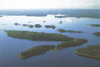
Photo: J.J.Kerekes
A. LOCATION
- Nova Scotia, Canada.
- 44:23N, 65:15W; 90 m above sea level.
B. DESCRIPTION
-
The oligotrophic Kejimkujik Lake in Kejimkujik National Park is lying on Devonian granite in central Nova Scotia approximately 60 km inland from the Atlantic Ocean and 40 km from the Bay of Fundy. Its drainage basin is covered by forest, bogs, lakes and a very limited amount of poor agricultural land (<1% of the watershed). About two-thirds of the drainage basin is outside of the National Park boundary which contains a permanent population of <100 people, has some roads and supports some forestry and a very limited amount of agriculture. Kejimkujik Lake is a local centre of summer recreation. Up to ca. 1,500-2,500 people may be present daily during peak periods of the summer season. Water flowing into the lake is influenced by bog soils and is high in organic acids. The lake has shown a high degree of acidification and reproductive failure of Atlantic salmon due to high acidity downstream from the lake has become apparent.
In response to the need for scientific knowledge of the potential impacts of the long-range transportation of air pollutants on freshwater ecosystems in Atlantic Canada, the Government of Canada initiated the Kejimkujik Calibrated Catchment Study Program, an interdisciplinary multi-agency study in 1980.
The lake is shallow and has a relatively high flushing rate (4.5 times yr-1), precipitation is 1,460 mm yr-1 and the runoff is 910 mm yr-1. The water is extremely dilute (sum of constituents = 13 mg l-1), and due to its relative closeness to the ocean, it is dominated by Na and Cl ions. Calcium and magnesium concentrations are extremely low (0.7 and 0.5 mg l-1, respectively); thus under the existing ca. 20 kg ha-1 yr-1 wet sulphate deposition, combined with the existing natural acidity, the lake responds with chronically depressed pH (4.8 annual mean). Studies in the lake and its tributaries showed that the additional sulphate deposition of anthropogenic origin gives additional acidity to the water, particularly during the winter and early spring, which explains the disappearance of Atlantic salmon downstream from the lake (Q).
C. PHYSICAL DIMENSIONS (6)
| Surface area [km2] | 26 |
| Volume [km3] | 0.106 |
| Maximum depth [m] | 19.2 |
| Mean depth [m] | 4.4 |
| Water level | Unregulated |
| Normal range of annual water level fluctuation [m] | 1.0 |
| Length of shoreline [km] | 45 |
| Residence time [yr] | 0.2 |
| Catchment area [km2] | 289 |
D. PHYSIOGRAPHIC FEATURES
D1 GEOGRAPHICAL- Sketch map: Fig. NAM-56-0l.
- Bathymetric map: Fig. NAM-56-02.
- Names of main islands
Peale, Hemlock, Norway, Dukeshire, Big Muise, Ell, Little Muise and Richie McLean (1.97 km2 in total area). - Number of outflowing rivers and channels (name): 1 (Mersey R.).
- Climatic data at Maitland Bridge, 1965-1980 (2a)
| Jan | Feb | Mar | Apr | May | Jun | Jul | Aug | Sep | Oct | Nov | Dec | Ann. | |
|---|---|---|---|---|---|---|---|---|---|---|---|---|---|
| Mean temp. [deg C] | -6.4 | -5.7 | -1.3 | 3.1 | 9.6 | 15.4 | 18.7 | 17.9 | 13.9 | 9.2 | 3.7 | -2.6 | 6.3 |
| Precipitation [mm] | 155 | 114 | 127 | 99 | 104 | 89 | 103 | 87 | 107 | 132 | 141 | 189 | 1,447 |
- Number of hours of bright sunshine: 1,785 hr yr-1.
- Solar radiation (Kentville CDA)[MJ m-2 day-1]
| Jan | Feb | Mar | Apr | May | Jun | Jul | Aug | Sep | Oct | Nov | Dec | Ann. |
|---|---|---|---|---|---|---|---|---|---|---|---|---|
| 4.95 | 8.48 | 12.45 | 15.26 | 18.90 | 21.18 | 20.48 | 18.32 | 14.11 | 9.04 | 5.14 | 3.71 | 12.7 |

Sketch map of Nova Scotia drainage basins (Q).
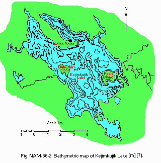
Bathymetric map [m](7).
- Water temperature [deg C](7)
| Deep Station off Peale Island, 1980 | ||||||||||||
| Depth [m] | Jan | Feb | Mar | Apr | May | Jun | Jul | Aug | Sep | Oct | Nov | Dec |
|---|---|---|---|---|---|---|---|---|---|---|---|---|
| 0 | 0.0 | 0.5 | - | 7.0 | 12.5 | 16.5 | 18.5 | 23.5 | 20.5 | 12.0 | 3.4 | 2.0 |
| 2 | 2.0 | 1.5 | - | 7.0 | 12.5 | 16.0 | 18.5 | 23.5 | 19.9 | 12.0 | 3.0 | 2.0 |
| 4 | 2.0 | 2.0 | - | 7.0 | 12.0 | 15.6 | 18.5 | 23.5 | 19.5 | 12.0 | 3.0 | 2.0 |
| 6 | 2.2 | 2.5 | - | 7.0 | 12.0 | 15.5 | 18.5 | 22.0 | 19.3 | 12.0 | 3.4 | 2.0 |
| 8 | 2.5 | 3.0 | - | 6.7 | 11.5 | 15.0 | 18.5 | 21.0 | 19.1 | 12.0 | 3.4 | 2.0 |
| 10 | 3.0 | 4.0 | - | 6.7 | 11.0 | 15.0 | 18.5 | 20.0 | 19.0 | 12.0 | 3.4 | 2.0 |
| 14 | 3.8 | 4.0 | - | 6.7 | 10.5 | 14.9 | 18.2 | 17.0 | 19.0 | 12.0 | 3.4 | 2.0 |
| 18 | 4.0 | 4.0 | - | 6.7 | 10.6 | - | - | - | - | - | 3.8 | 2.0 |
- Freezing period: End of December-middle April.
- Mixing type: Dimictic.
- Notes on water mixing and thermocline formation
Summer thermal stratification is restricted mainly to a relatively small depression near Peale Island. Hypolimnion is absent.
E. LAKE WATER QUALITY
E1 TRANSPARENCY [m](7)| Deep Station, 1980 | |||||||||||
| Jan | Feb | Mar | Apr | May | Jun | Jul | Aug | Sep | Oct | Nov | Dec |
|---|---|---|---|---|---|---|---|---|---|---|---|
| 1.3 | 1.27 | - | 1.75 | 1.75 | 2.23 | 1.35 | 1.8 | 2.45 | 2.31 | 2.07 | 1.75 |
| Deep Station, 1980 | ||||||||||||
| Depth [m] | Jan | Feb | Mar | Apr | May | Jun | Jul | Aug | Sep | Oct | Nov | Dec |
|---|---|---|---|---|---|---|---|---|---|---|---|---|
| 0 | 4.55 | 4.6 | - | 4.8 | 4.8 | 4.6 | 4.9 | 4.9 | 4.9 | 5.1 | 4.5 | 4.6 |
| 2 | 4.6 | 4.7 | - | 4.8 | 4.7 | 4.7 | 4.9 | 4.9 | 5.0 | 5.1 | 4.7 | 4.6 |
| 4 | 4.7 | 4.6 | - | 4.8 | 4.7 | 4.7 | 4.9 | 5.0 | 4.9 | 5.1 | - | 4.6 |
| 6 | 4.7 | 4.6 | - | 4.7 | 4.6 | 4.7 | 4.9 | 5.0 | 5.0 | - | - | 4.6 |
| 8 | 4.7 | 4.6 | - | 4.7 | 4.6 | 4.7 | 4.9 | 5.0 | 5.0 | 5.1 | - | 4.6 |
| 10 | 4.7 | 4.6 | - | 4.7 | 4.6 | 4.7 | 4.8 | 4.9 | 5.0 | - | 4.9 | 4.6 |
| 14 | 4.8 | 4.7 | - | 4.7 | 4.6 | 4.6 | 4.8 | 4.8 | 5.0 | 5.1 | - | 4.6 |
| 18 | 4.8 | 4.7 | - | 4.7 | 4.6 | 4.6 | - | - | - | - | 4.9 | 4.6 |
- Negligible levels.
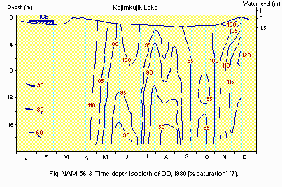
Time-depth isopleth of DO, 1980 [% saturation](7).
E6 CHLOROPHYLL CONCENTRATION: Fig. NAM-56-04.
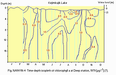
Time-depth isopleth of chlorophyll a at Deep station, 1979 [micro l-1](7).
E7 NITROGEN CONCENTRATION (5)
- Total-N [mg l-1]
Deep station, 1981: 0.76.
- Total-P [micro l-1]
Deep station, 1981: 9.1.
- Outflow, 1978-1979: 4.53.
F. BIOLOGICAL FEATURES
F1 FLORA- Emerged macrophytes (5)
- Floating macrophytes (5)
- Submerged macrophytes (5)
- Phytoplankton (2)
Equisetum fluviale, Sparganium americanum, S. minimum, Calamagrostis canadensis, Eleocharis acicularis, Scirpus subterminalis, Rhynchospora alba, Eriocaulon septangulare, Pontederia cordata, Juncus brevicaudatus, J. effusus, J. militaris, Lobelia dortmanna, Hydrocotyle umbellata, Sium suave.
Nuphar variegatum, Nymphaea odorata, Brasenia schreberi, Nymphoides cordata.
Isoetes macrospora, Potamogeton confervoides, P. epihydris, P. robbinsii, P. spirillus, Utricularia cornuta.
Diatoms (Asterionella formosa, Tabellaria fenestrata, T. flocculosa. Rhizosolenia eriensis); Greens (Selenastrum minutum, Sphaerocystis schroeteris, Schroederia setigera, Tetradesmus wisconsinensis); Blue-greens (Agmenellum thermale); chrysophyceans (Mallomonas caudata, Dinobryon bavaricum); cryptophyceans (Cryptomonas ovata); xanthophyceans (Chlorochromonas minuta).
- Zooplankton (2)
- Benthos (5)
Cladocerans (Daphnia ambigua, D. catawba, Bosmina longirostris, Eubosmina longispina, E. tubicen, Holopedium gibberum, Leptodora kindtii, Diaphanosoma leuchtenbergianum); Copepods (Epischura nordenskioldi, Diaptomus minutus, D. oregonensis, Mesocyclops edas, Tropocyclops sp.); Rotifers (Keratella cochlearis, Kellicottia bostoniensis, Polyarthra vulgaris, Conochilus unicornis).
Benthic macroinvertebrates in Kejimkujik Lake (Jeremy Bay; 9 samples), Beaverskin Lake (4 samples) and Pebbleloggitch Lake (4 samples). Mean data for the three lakes and 4 sampling dates (May, July, August and September 1980).
| Density [no m-2] | [%] | ||
|---|---|---|---|
| Insecta | Ephemeroptera | 30 | 2.8 |
| Odonata | 7 | 0.7 | |
| Plecoptera | 4 | 0.4 | |
| Neuroptera | 1 | 0.1 | |
| Megaloptera | 1 | 0.1 | |
| Trichoptera | 27 | 2.5 | |
| Coleoptera | 1 | 0.1 | |
| Lepidoptera | 0 | 0.0 | |
| Diptera | 241 | 22.5 | |
| Crustacea | Crustacea | 144 | 13.5 |
| Ostracoda | 6 | 0.6 | |
| Cladocera | 175 | 16.4 | |
| Amphipoda | 91 | 8.5 | |
| Isopoda | 78 | 7.3 | |
| Oligochaeta | Naididae | 217 | 20.3 |
| Lumbricuridae | 7 | 0.7 | |
| Enchytraeidae | 1 | 0.1 | |
| Tubificidae | 7 | 0.7 | |
| Mollusca | Gastropoda | 1 | 0.1 |
| Sphaeriidae | 4 | 0.4 | |
| Turbellaria | 1 | 0.1 | |
| Arachnida | Hydracarina | 2 | 0.2 |
| Nematoda | 20 | 1.9 | |
| Total | 1,066 | 100 |
- Fish (5)
Coregonus clupeaformis (lake whitefish), Salmo trutta (brown trout), Salvelinus fontinalis (brook trout), Notemigonus chrysoleucas (golden shiner), Catostomus commersoni (white sucker), Ictalurus nebulosus (brown bullhead), banded killfish, ninespine stickleback, Morone americana (white perch), Perca flavescens (yellow perch), Anguilla rostrata (American eel).
- Phytoplankton
Net production rate [g C m-2 yr-1]
| Deep station, May 1979-April 1981 | ||||||||||||
| Jan | Feb | Mar | Apr | May | Jun | Jul | Aug | Sep | Oct | Nov | Dec | Ann. |
|---|---|---|---|---|---|---|---|---|---|---|---|---|
| 13.9 | 31.8 | 120 | 112 | 105 | 122 | 147 | 113 | 238 | 136 | 87.1 | 32.6 | 25.3 |
- 1,100 angling licenses issued in 1988.
- Atlantic salmon became extinct in the 1920's because of a series of seven power dams downstream from the lake.
G. SOCIO-ECONOMIC CONDITIONS (Q)
G1 LAND USE IN THE CATCHMENT AREA| Area [km2] | [%] | |
|---|---|---|
| Natural landscape Forest, bogs and lakes | ca. 286 | 99 |
| Agricultural land | <3 | <1 |
| Total | 289 | 100 |
- Levels of fertilizer application on crop fields: Light.
- None.
H. LAKE UTILIZATION (8)
H1 LAKE UTILIZATION- Sightseeing and tourism (no. of visitors in 1988: 217,000) and recreation (swimming, canoeing, sport-fishing, angling).
I. DETERIORATION OF LAKE ENVIRONMENTS AND HAZARDS
I1 ENHANCED SILTATION- Extent of damage: None.
- Present status: None.
- Nitrogen and phosphorus loadings to the lake [t yr-1] (1971)
| Sources | Total |
|---|---|
| T-P | 7.3 |
- Extent of damage: Serious.
- Kinds of damage
Reduction of the number of fish species previously present (10); depressed pH levels (11, 12).
J. WASTEWATER TREATMENTS
J1 GENERATION OF POLLUTANTS IN THE CATCHMENT AREA- (b) No sources of significant pollution.
- Municipal wastewater treatment systems
No. of primary treatment systems: 2 (setting sewage lagoons hold campground wastewater during the summer).
M. LEGISLATIVE AND INSTITUTIONAL MEASURES FOR UPGRADING LAKE ENVIRONMENTS
M1 NATIONAL AND LOCAL LAWS CONCERNED- Names of the laws (the year of legislation)
- National Parks Act (1930, last amendment C48 in 1988)
- Responsible authorities
- Canadian Parks Service
- Since 1978, Kejimkujik Lake and its tributaries have been a major study site in Atlantic Canada to study the impact of long range transport of air pollutants and a selected site for future monitoring. This is a multi-agency study of the Canadian Wildlife Service, Inland Water Directorate, Atmospheric Environment Service, Canadian Forestry Service, Canadian Parks Service, and Department of Fisheries and Oceans.
N. SOURCES OF DATA
- Questionnaire filled by Dr. J. J. Kerekes, Canadian Wildlife Service, Bedford Institute of Oceanography, Nova Scotia, Canada.
- Beauchamp, S. T. (1983) Planktonic primary production in three acid- stressed lakes in Nova Scotia. 194 pp. M. Sc. Thesis, Dalhousie University, Halifax, N. S.
- Blouin, A. C., Lane, P. A., Collins, T. M. & Kerekes, J. (1984) Comparison of plankton-water chemistry relationships in three acid stressed lakes. Int. Revue. ges. Hydrobiol., 69: 819-841.
- ) Canadian Climate Normals (1951-1980). Environment Canada, Atmospheric Environment Service.
- Kerekes, J. (1975) Aquatic Resources Inventory, Kejimkujik National Park, Nova Scotia. Part 6. Limnological Conditions in Thirty Lakes. Manuscript report. 89 pp. Canadian Wildlife Service, Environment Canada.
- Kerekes, J. (1975c) Phosphorus supply in undisturbed lakes in Kejimkujik National Park, Nova Scotia (Canada). Verh. internat. Limnol., 19: 349- 357.
- Kerekes, J. & Freedman, B. (1989) Characteristics of three acidic lakes in Kejimkujik National Park, Nova Scotia, Canada. Arch. Environ. Contam. Toxicol., 18: 183-200.
- Kerekes, J. & Schwinghamer, P. (1973a) Aquatic Resources Inventory, Kejimkujik National Park, Nova Scotia. Part 2. Lake Drainage and Morphometry. Manuscript repo
