
SHUSWAP LAKE
View of Station 5 looking north, Copper Island in the background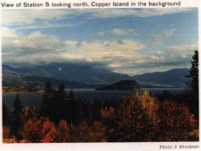
Photo: J.Stockner
A. LOCATION
- British Columbia, Canada.
- 50:0-51:0N, 119:0-119:0W; 347 m above sea level.
B. DESCRIPTION
Shuswap Lake is situated in the Columbia Mountains region of British Columbia where the landscape is characterized by mountainous terrain covered by dense coniferous forests. White birch lines settled areas of the lake shore adding to the beauty of the lake during fall. The mountains surrounding the lake are formed of granite which results in a very low input of nutrients. As a result, Shuswap Lake is very clear and relatively oligotrophic. The high mountains around this lake may reduce its annual solar radiation.This multi-basin lake is comprised of 4 arms which are joined by a short shallow passage known as the "narrows." The two south arms are developed for recreational use while the two north arms remain undeveloped. The lake has several inflow rivers in each arm but only one outlet, Little River, which flows from the southwest arm to Little Shuswap Lake. Shuswap is a nursery lake for the underyearlings of sockeye salmon which spawn in several of the lake's inflow streams. Adams River is the most conspicuous of these spawning streams, accommodating up to 2 million spawners in dominant years.
Besides being of considerable value to the west
coast salmon industry, moderate weather, clear water and easy accessibility
make Shuswap Lake highly desirable as a recreational area. This is evidenced
by the many provincial parks surrounding the lake and the hundreds of houseboats
and pleasure crafts present during the summer months (Q).
C. PHYSICAL DIMENSIONS
| Surface area [km2] | 310 |
| Volume [km3] | 19.1 |
| Maximum depth [m] | 161 |
| Mean depth [m] | 62 |
| Water level | Unregulated |
| Normal range of annual water level fluctuation [m] | 3.0 |
| Length of shoreline [km] | 1,430 |
| Residence time [yr] | 2.1 |
| Catchment area [km2] | 16,200 |
D. PHYSIOGRAPHIC FEATURES
D1 GEOGRAPHICAL
- Bathymetric map: Fig. NAM-47-01.
- Names of main islands: Copper.
- Number of outflowing rivers and channels (name): 1 (Little R.).
D2 CLIMATIC
- Climatic data at Sicamous, 1951-1980 (2)
| Jan | Feb | Mar | Apr | May | Jun | Jul | Aug | Sep | Oct | Nov | Dec | Ann. | |
|---|---|---|---|---|---|---|---|---|---|---|---|---|---|
| Mean temp. [deg C] | -5.0 | -1.4 | 2.4 | 7.8 | 13.1 | 17.1 | 20.0 | 19.2 | 14.0 | 7.7 | 1.5 | -2.6 | 7.8 |
| Precipitation [mm] | 77 | 48 | 37 | 32 | 51 | 64 | 46 | 53 | 56 | 51 | 66 | 80 | 660 |
- Number of hours of bright sunshine (Salmon Arm): 1,632 hr yr-1 (2).
- Solar radiation (Summerland)[MJ m-2 day-1]*
| Jan | Feb | Mar | Apr | May | Jun | Jul | Aug | Sep | Oct | Nov | Dec | Ann. |
|---|---|---|---|---|---|---|---|---|---|---|---|---|
| 3.4 | 6.5 | 11.5 | 16.7 | 20.8 | 22.6 | 23.7 | 19.6 | 14.5 | 8.5 | 3.8 | 2.5 | 12.8 |
Fig. NAM-47-01
Bathymetric map [50 ft=15.24 m](8).

- Water temperature [deg C](1)
| Depth J[m] | an | Feb | Mar | Apr | May | Jun | Jul | Aug | Sep | Oct | Nov | Dec |
|---|---|---|---|---|---|---|---|---|---|---|---|---|
| S*2 | - | - | - | 11.6 | 11.3 | 19.2 | 21.0 | 18.9 | 17.7 | 12.5 | 9.6 | - |
| 3 | - | - | - | 8.3 | - | 18.6 | 20.0 | 18.8 | 17.7 | 12.5 | 9.6 | - |
| 6 | - | - | - | 7.0 | 10.4 | 17.7 | 19.1 | 18.7 | 17.6 | 12.5 | 9.6 | - |
| 9 | - | - | - | 5.9 | 9.8 | 14.3 | 17.6 | 18.4 | 17.3 | 12.5 | 9.6 | - |
| 12 | - | - | - | 5.6 | - | 11.7 | 13.2 | 14.8 | 17.2 | 12.5 | 8.2 | - |
| 15 | - | - | - | 5.0 | 8.5 | - | 12.2 | 11.7 | 16.9 | 12.5 | 6.6 | - |
| 18 | - | - | - | 4.8 | - | - | 11.4 | - | 10.0 | - | 6.4 | - |
| 21 | - | - | - | 4.6 | 4.6 | - | - | - | - | - | - | - |
| 28 | - | - | - | 4.5 | - | 5.8 | 5.6 | 5.2 | 5.7 | 5.2 | - | - |
*2 Surface.
- Freezing period: January-March (not freeze every year and not freeze over).
- Mixing type: Dimictic.
E. LAKE WATER QUALITY
- Water quality is variable. The Salmon Arm is the most productive area
because of considerable nutrient input from agricultural drainage via the
Salmon River. Levels of nutrients are highest in Salmon Arm and lowest
in Austy and Seymour Arms.
E1 TRANSPARENCY [m](Q)
| Jan | Feb | Mar | Apr | May | Jun | Jul | Aug | Sep | Oct | Nov | Dec |
|---|---|---|---|---|---|---|---|---|---|---|---|
| - | - | - | 11.5 | 8.2 | 13.7 | 10.5 | 11.0 | 10.8 | 10.6 | 8.6 | - |
E2 pH (Q)
| Depth J[m] | Jan | Feb | Mar | Apr | May | Jun | Jul | Aug | Sep | Oct | Nov | Dec |
|---|---|---|---|---|---|---|---|---|---|---|---|---|
| S* | - | - | - | 7.8 | 7.6 | 7.7 | 7.3 | 7.7 | 7.9 | 7.5 | 7.3 | - |
E6 CHLOROPHYLL CONCENTRATION [micro l-1](Q)
| Depth J[m] | Jan | Feb | Mar | Apr | May | Jun | Jul | Aug | Sep | Oct | Nov | Dec |
|---|---|---|---|---|---|---|---|---|---|---|---|---|
| ME* | - | - | - | 0.91 | 0.70 | 1.60 | 1.18 | 0.98 | 1.04 | 1.62 | 2.29 | - |
E7 NITROGEN CONCENTRATION (Q)
- NO3-N+NH4-N [mg l-1]
| Depth J[m] | Jan | Feb | Mar | Apr | May | Jun | Jul | Aug | Sep | Oct | Nov | Dec |
|---|---|---|---|---|---|---|---|---|---|---|---|---|
| ME*1 | - | - | - | .094 | .068 | .013 | .002 | .001 | .006 | .008 | .026 | - |
| *2 | - | - | - | .015 | .007 | .011 | .003 | .003 | .006 | .006 | .007 | - |
E8 PHOSPHORUS CONCENTRATION (8)
- Total-P [micro l-1]
| Depth J[m] | Jan | Feb | Mar | Apr | May | Jun | Jul | Aug | Sep | Oct | Nov | Dec |
|---|---|---|---|---|---|---|---|---|---|---|---|---|
| ME* | - | - | - | 5.7 | 3.0 | 3.8 | 4.0 | 2.9 | 2.4 | 2.4 | 3.6 | - |
E9 CHLORIDE CONCENTRATION [mg l-1](4)
- Station 5, 1982: 0.5.
F. BIOLOGICAL FEATURES
Fl FLORA (4)- Emerged macrophytes
- Floating macrophytes
- Submerged macrophytes
- Phytoplankton
Equisetum sp., Alisma plantago-aquatica, A. gramineum, Scheuchzeria palustris, Acorus calanus, Ranunculus flabellaris, Sium sauve, Eleochoris palustris.
Polygonum amphibium, Azolla filiculoides, Nuphar variegatum.
Myriophyllum exalbescens, M. ussuriense, M. spicatum, Potamogeton zosteriformis, P. robbinsii, P. pectinatus, P. praelongus, P. noclosus, P.
crispus, P. epihydrus, P. illinoensis, P. perfoliatus, P. pusilus, Chara sp., Nitella sp., Callitriche hermaphroditica, C. heterophylla, C. stagnalis, Hippurus vulgaris, Zannichellia palustris, Bidens beckii, Utricularia vulgaris, U. intermedea, Elodea canadensis, Najas flexilis, Ceratophyllum demersum, Heteranthera dubia.
Cyclotella spp., Rhizosolenia spp., Asterionella spp., Dinobryon spp., Melosira spp.
F2 FAUNA
- Zooplankton (5, 6)
- Fish
Bosmina coregoni (longispina), B. longirostris, Diaphanosoma leuchtenbergianum, Daphnia thorata, D. longiremis, Holopedium gibberum, Sida crystallina, Cyclops bicuspidatus thomasi, Diaptomus ashlandi, Epischura nevadensis.
Oncorhynchus nerka*, O. tshawytscha*, Salmo gairdneri*, Salvelinus malma, S.
namaycush, Coregonus clupeaformis, Prosopium williamsoni, Richardsonius balteatus, Lota lota, Cottus asper.
* Economically important.
F3 PRIMARY PRODUCTION RATE [mg C m3 hr-1](1)
| Jan | Feb | Mar | Apr | May | Jun | Jul | Aug | Sep | Oct | Nov | Dec |
|---|---|---|---|---|---|---|---|---|---|---|---|
| - | - | - | 0.23 | 1.0 | 1.3 | 1.67 | 1.0 | 0.67 | 0.93 | 1.29 | - |
F4 BIOMASS (6)
- Station 5 (Sorrento), 1987*
- Bacteria [cells ml-1]: 480,000.
- Zooplankton [mg (dry wt.) m-3]: 45.9.
* Early mean values.
F5 FISHERY PRODUCTS(Q)
- Annual fish catch [metric tons]
- Supplementary notes
20
Anadromus sockeye salmon is caught at sea during the commercial catch in the dominant year. Its returns are cyclic with a dominant return occurring every four years. This cyclic dominance is thought to have varying degrees of influence on all trophic levels, since dominant returns are 230 times greater than low year returns. Sockeye underyearling grazing structures the zooplankton community of the hypolimnion-thermocline area but, because of warm surface temperatures of the epilimnion in summer, the zooplankton community there is less affected. Depending on the time of year, nutrients affect community composition and size-structure of phytoplankton.
F7 NOTES ON THE REMARKABLE CHANGES OF BIOTA IN THE LAKE IN RECENT YEARS
- Increase in Eurasian milfoil (Myriophyllum spicatum) colonization of
the littoral zone.
G. SOCIO-ECONOMIC CONDITIONS
G1 LAND USE IN THE CATCHMENT AREA (8)
| Area [km2] | [%] | |
|---|---|---|
| Natural landscape | ||
| - Woody vegetation | 12,393 | 76.5 |
| - Herbaceous vegetation | 1,377 | 8.5 |
| Agricultural land | ||
| - Crop field | 729 | 4.5 |
| - Pasture land | 1,458 | 9 |
| Residential area | 243 | 1.5 |
| Total | 16,200 | 100 |
- Types of important forest vegetation
- Main kinds of crops and/or cropping systems
- Levels of fertilizer application on crop fields: Light.
- Trends of change in land use in recent years
Pseudosuga menziesii (Douglas fir), Pinus contorta (lodge-pole pine), Betula papyrifera (white birch).
Corn, various fruit, hay, alfalfa
Increase in recreational boating, fishing and shoreline development of summer houses.
G2 INDUSTRIES IN THE CATCHMENT AREA AND THE LAKE
- 1987
This is an area of little urban industrial development. The largest agglomeration, Salmon Arm, has a population, in 1981, of 10,780 and only a few service functions.
G3 POPULATION IN THE CATCHMENT AREA (9)
| Population | Population density [km-2] | Major cities (population) | |
|---|---|---|---|
| Urban | ca. 10,000 | Salmon Arm | |
| Rural | ca. 5,000 | (10,780) | |
| Total | 15,000* | 0.9 |
H. LAKE UTILIZATION
H1 LAKE UTILIZATION
- Source of water, navigation and transportation (not commercial except
for some log transport), sightseeing and tourism (no. of visitors in 1987:
over 10,000), recreation (swimming, sport-fishing and yachting), fisheries
and hundreds of house boats cruise the lake each year.
H2 THE LAKE AS WATER RESOURCE
| Use rate | |
|---|---|
| Domestic | From wells+tributaries |
| Irrigation | Not estimated |
| Industrial | Saw mill |
I. DETERIORATION OF LAKE ENVIRONMENTS AND HAZARDS
I1 ENHANCED SILTATION
- Extent of damage: None.
I2 TOXIC CONTAMINATION
- Present status: No information.
I3 EUTROPHICATION
- Nuisance caused by eutrophication
Increase of Eurasian milfoil (Myriophyllum spicatum). There has been mild eutrophication of the Salmon Arm.
I4 ACIDIFICATION
- Extent of damage
- Supplementary notes
Slight acidification detected in watershed, but not serious.
Hydrogen ion concentrations in lake water, stream and rain water have been stable. The lake water has a hardness of 39 and an alkalinity of 34 mg l-1 (conductivity 81 micro S cm-1), and relatively well-buffered with a pH value typically above 7 (1982 pH mean was 7.4).
J. WASTEWATER TREATMENTS
J1 GENERATION OF POLLUTANTS IN THE CATCHMENT AREA
- (c) Limited pollution with wastewater treatment.
J2 APPROXIMATE PERCENTAGE DISTRIBUTION OF POLLUTANT LOADS
| [%] | |
|---|---|
| Non-point sources (agricultural, natural and dispersed settlements) | 75 |
| Point sources Municipal | 25 |
J3 SANITARY FACILITIES AND SEWERAGE
- Municipal wastewater treatment systems
Tertiary treatment with outflow to the lake at depth of 3 m. The effluent contains <10 ppm suspended solids.
L. DEVELOPMENT PLANS
- Development and activity in the Shuswap Lake watershed has intensified
in recent years. Upland residential development, increased residential
use and selected commercial developments along the lake's shorelines have
impacted on its environmental resources. As a result, the Shuswap Lake
Environmental Management Plan was undertaken by the B. C. Ministry of Environment
(10). During 1985 the Regional District of Columbia Shuswap initiated a
management program for the lake. The following are some of the actions
and recommendations taken by this agency.
The spread of Eurasian water milfoil in Shuswap Lake has resulted in the implementation of a mechanical harvesting control program in 1981. To date, the density of this macrophyte remains low (11, 12).
Water quality in the relatively enclosed portion of Tappen Bay and Salmon Arm (Fig. NAM-47-0l) failed to meet the Provincial guidelines for phosphorus for fisheries and recreational uses (10). Tributary streams are also enriched with phosphorus from agricultural inputs rather than from septic systems. A major water quality monitoring program has been set up to determine the optimal waste treatment management program for the lake and to determine appropriate methods for reducing phosphorus loadings (10).
Given the historical patterns of activity and risk that have been commonly associated with alluvial fans, it was recommended that no more development occur on five of the major alluvial fans in the Shuswap Watershed (13).
Given the importance of shoreline areas in the production of fisheries and waterfowl resources, a shoreline habitat protection program was recommended and special action has been taken to protect the Western Grebe colony along the foreshore east of the Salmon River as well as the Bighorn Rocky Mountain Sheep near Chase. Finally, wildlife habitat areas in the Salmon River estuary, the mouth of the Eagle River, Seymour River estuary and Bughouse Bay areas have been kept free of development (10). A fisheries management study is currently underway to assess fishery production and to determine areas for special attention (10).
M. LEGISLATIVE AND INSTITUTIONAL MEASURES FOR UPGRADING LAKE ENVIRONMENTS
M1 NATIONAL AND LOCAL LAWS CONCERNED
- Names of the laws (the year of legislation)
- Federal Fisheries Act
- Canada Water Act
- Responsible authorities
- Ministry of Environment, Waste Management Branch
- Ministry of Environment, Fish and Wildlife
- Main items of control
- Protection of anadromous fish species
- Waste disposal
- Fishing and hunting regulations
- Domestic and commercial water usage
- (l) Department of Fisheries and Oceans
M2 INSTITUTIONAL MEASURES
- British Columbia Ministry of the Environment, Kamloops, BC.
- British Columbia Ministry of Forests, Kamloops, BC.
- Environment Canada, Atmospheric Environment Service, Kamloops, BC.
- Salmon Arm Chamber of Commerce, Mclead Avenue, Salmon Arm, BC.
- Mr. Fred Harper, Regional Wildlife Biologist
M3 RESEARCH INSTITUTES ENGAGED IN THE LAKE ENVIRONMENT STUDIES
- Canada Department of Fisheries and Oceans, Biological Sciences Branch, West Vancouver, BC.
- British Columbia, Ministry of the Environment, Fish and Wildlife Branch
- British Columbia, Ministry of the Environment, Waste Management Branch
N. SOURCES OF DATA
- Questionnaire filled by Dr. J. G. Stockner, Department of Fisheries and Oceans, West Vancouver Laboratory, West Vancouver, British Columbia.
- Stockner, J. G. & Shortreed, K. S. (1983) A Comparative Limnological Survey of 19 Sockeye Salmon (Oncorhynchus nerka) Nursery Lakes in the Fraser River System, British Columbia. Department of Fisheries and Oceans. Can. Tech. Rep. of Fish. and Aquat. Sci. 1190 pp.
- Canadian Climate Normals. 1951-1980. Temperature and Precipitation. Environment Canada, Atmospheric Environment Service.
- Canadian Climate Normals. 1951-1980. Solar Radiation. Environment Canada, Atmospheric Environment Service.
- Hebdem, B., Ministry of Environment. Personal communication.
- Ward, F. J. (1957) Seasonal and Annual Changes in Availability of the Adult Crustacean Plankters of Shuswap Lake. International Pacific Salmon Fisheries Commission, Progress Report no. 3.
- Goodlad, J. C., Gjernes, T. W. & Brannon, E. L. (1974) Factors affecting sockeye salmon (Oncorhynchus nerka) growth in four lakes of the Fraser River system. J. Fish. Res. Board Can., 31: 871-892.
- Ward, F. J. & Larkin, P. A. (1964) Cyclic Dominance in Adams River Sockeye Salmon. International Pacific Salmon Fisheries Commission, Progress Report no. 11.
- NTS scale 1:250,000 Vernon British Columbia Sheet 82L/edition 1 (1963).
- Census of Canada (1981) Population Series, British Columbia, pp. 93-910, Table 4.
- B. C. Ministry of Environment (1987) Shuswap Lake Environmental Management Plan. B. C. Ministry of Environment, West Vancouver, British Columbia.
- Einarson, E. D. (1986) The 1985 Eurasian Water Milfoil Surveilance and Control Program in Shuswap Lake. Littoral Resources Unit, Water Management Branch, B. C. Ministry of Environment Resource Quality Section, Water Management Branch, B. C. M. 0. E., Victoria.
- Einarson, E. D. (1986) Preliminary Assessment of Water Quality of Shuswap Lake Area. Unpublished manuscript. Resource Quality Section, Water Management Branch, B. C. M. 0. E., Victoria, B. C. 15 pp.
- Thurber Consultants (1983) Floodplain Management on Alluvial Fans. Report to the Ministry of the Environment, Water Quality Branch, B. C. M.
0. E., Victoria.
