
LAKE AMATITLAN
Anevening view from the lakeside hill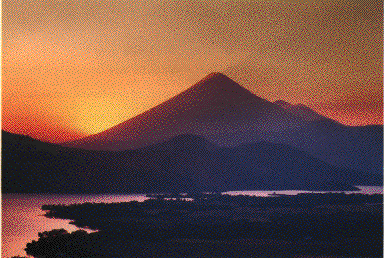
Photo: V. R. Escobar Ulloa
A. LOCATION
- Amatitlan, Guatemala.
- 14:8N, 90:6W; 1,188 m above sea level.
B. DESCRIPTION
Lake Amatitlan (amatl = letter, titlan = mail in the pipil language) is the fourth largest water body in Guatemala, located close to the south of the capital city (alt. 1,500 m) at an altitude of 1,188 m above sea level. The lake consists of two basins connected by a narrow constriction, where a dry dock was constructed to let the railway pass through. This separated the lake into two water bodies with different physical, chemical and biological charac- teristics. The western basin receives all pollution loads coming from the southern part of the capital city as well as from the whole catchment area via the Villalobos River. The water of the same basin is drained by the Michatoya River, which is used for hydroelectric power generation.The lake is directly and negatively affected by the rapidly growing impacts from the capital area, through 1) population growth, 2) consumption of forest trees for fuel, 3) inadequate land use, 4) industrial development in the catchment area, 5) lack of environment consciousness and environmental education among the inhabitants, 6) almost no administrative/legal control for environmental protection, and 7) absence of proper foresight and management program.
Despite these circumstances, L. Amatitlan and surrounding
valleys, mountains and nearby volcanoes present a unique landscape, making
the area a recreation park for a lot of visitors. The lake has also been
used in other multiple ways. In pre-Columbian days, it was a place for
rituals where offerings were deposited. During the colonial times, the
lake was a center of fisheries and its catchment area was the most important
site of production of cochineal, which was the main product for export
when industrial chemicals had not yet replaced the natural dye. The lake
water is also being used for domestic use, irrigation and industrial activities
(13, 28, 29).
C. PHYSICAL DIMENSIONS
| Surface area [km2] | 15.2 |
| Volume [km3] | 0.286 |
| Maximum depth [m] | 33 |
| Mean depth [m] | 18 |
| Water level | Unregulated |
| Normal range of annual water level fluctuation [m] | 1.5 2.3 |
| Catchment area [km2] | 368 |
D. PHYSIOGRAPHIC FEATURES
D1 GEOGRAPHICAL
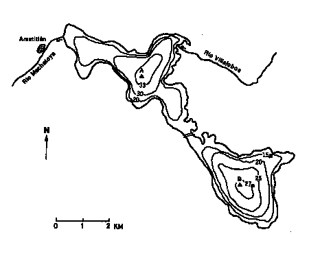
- Bathymetric map: Fig. NAM-41-1.
- Number of main islands: None.
- Number of outflowing rivers and channels (name): 1 (Michatoya R.).
D2 CLIMATIC
- Climatic data (17)
| Jan | Feb | Mar | Apr | May | Jun | Jul | Aug | Sep | Oct | Nov | Dec | Ann. | |
|---|---|---|---|---|---|---|---|---|---|---|---|---|---|
| Mean temp. [deg C]*1 | 18.0 | 19.0 | 21.0 | 21.4 | 20.8 | 20.9 | 21.2 | 20.9 | 19.8 | 20.4 | 20.3 | 20.9 | 20.4 |
| Precipitation [mm]*2 | 6 | 13 | 29 | 21 | 133 | 219 | 179 | 215 | 214 | 88 | 6 | 1 | 1,124 |
- Number of hours of bright sunshine (1986): 1,716.8 hr yr-1 (17).
- Solar radiation: 18.6 MJ m-2 day 1 (17).
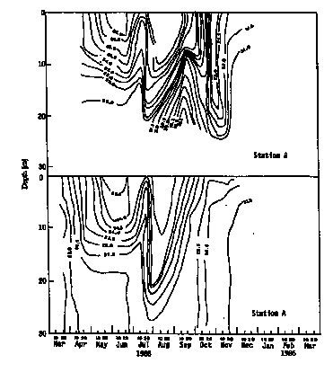
- Water temperature [deg C](4)
Range; 22.5 27.0 (1988).
- Fig. NAM-41-1
Bathymetric map [m](31).
- Fig. NAM-41-2
Seasonal and vertical distribution of water temperature [deg C].
E. LAKE WATER QUALITY
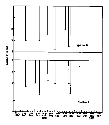
E1 TRANSPARENCY [m](4), 1988.
- Secchi disc: Range; 1.00 2.75 (mean 1.75).
Fig. NAM-41-3
Secchi disc transparency.
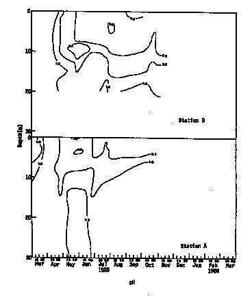
E2 pH (4)
- Range, 1988; 6.1 9.1 (mean 8.2 7.9).
Fig. NAM-41-4: pH profiles.
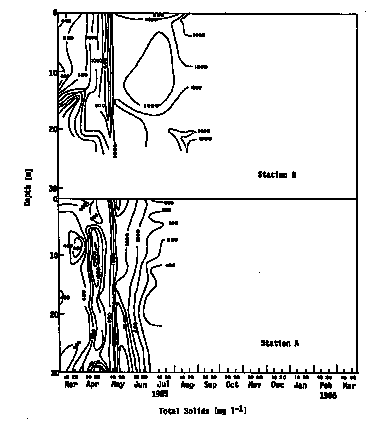
E3 SS [mg l-1](3)
- Range; 395 500.
Fig. NAM-41-5
Total solid profiles [mg l-1].
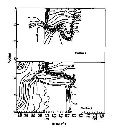
E4 DO [mg l-1](3)
Range; 4 10.- Fig. NAM-41-6: DO profiles [mg l-1].
E5 COD [mg l-1](3)
- Range; 1 9.
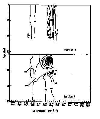
E6 CHLOROPHYLL CONCENTRATION [mg l-1](4)
- 1988
Minimum: 0.37, maximum: 2.00, annual mean: 10.75.
Fig. NAM-41-7: Chlorophyll concentration profiles [mg l-1].
E7 NITROGEN CONCENTRATION
- Total-N [mg l-1](4)
Annual mean, 1988; 0.628 (dry season 0.433, rainy season 0.864).
E8 PHOSPHORUS CONCENTRATION (4)
- Total-P [mg l-1]
Annual mean, 1988 ; 0.44 (dry season 0.62, rainy season 0.32).
E9 CHLORIDE CONCENTRATION [mg l-1](3)
- Range; 133 168.
F. BIOLOGICAL FEATURES
F1 FLORA
- Emerged macrophytes: Jussiaea peruviana, Typha, Scirpus (9, 14).
- Floating macrophytes: Eichhornia crassipes (9).
- Submerged macrophytes (23)
- Phytoplankton (30)
Potamogeton perfoliatus, Ceratophyllum demersum, Elodea sp.
Cyanophyceae (Microcystis aeruginosa, Microcystis sp., Lyngbya limnetica, Merismopedia sp., Nostoc sp.); Chlorophyceae (Kirchneriella obesa, K. sp., Oocystis sp., Closterium sp., Staurastrum sp.); Dinophyceae (Ceratium sp.); Bacillariophyceae (Tabellaria sp., Melosira granulata, Nitzschia sp., N.
acicularis, Diatoma sp., Surirella sp.).
F2 FAUNA
- Fish (14)
Cichlasoma nigrafasciatum, C. godmanii*, C. sp. (guapote)*, Astianax fasciates, Tilapia mossambica* (* economically important).
F5 FISHERY PRODUCTS (14)
- Annual fish catch [metric tons]
180 (120 kg ha-1).
G. SOCIO-ECONOMIC CONDITIONS
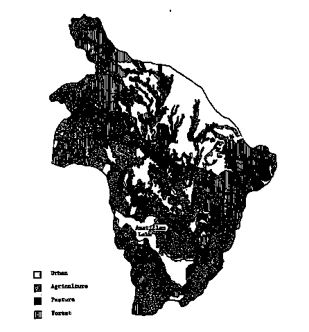
G1 LAND USE IN THE CATCHMENT AREA (29)
| Area [km2] | [%] | |
|---|---|---|
| Natural landscape | ||
| - Woody vegetation | ||
| -- Natural forest | 83.21 | 23 |
| -- Secondary growth | 27.39 | 7 |
| -- Planted forest | 2.25 | 1 |
| Agricultural land | ||
| - Annual crop | 72.07 | 20 |
| - Perennial crop | 49.39 | 13 |
| Vegetable | 3.87 | 1 |
| - Pasture | 52.16 | 14 |
| Urban residential area | 55.88 | 15 |
| Industrial area | 7.1 | 2 |
| Recreation area | 6.16 | 2 |
| Others | 8.12 | 2 |
| Total | 368.00 | 100 |
- Main species of planted forest
- Main kinds of crops and cropping systems
- Levels of fertilizer application on crop field: Moderate.
- Trends of change in land use in recent years
Cupressus lusitanica, Pinus oocarpa, Eucalyptus spp. (11).
Maize, sorghum, wheat, beans, coffee, sugar cane, banana and other fruits, vegetables, flowers. Cropping systems range widely from traditional ways to modern systems with irrigation, fertilization, control of pests and diseases, use of improved seeds and greenhouses (2, 12).
Recent changes consisted basically of the increase of human settlements without any urban planning; deforestation due to firewood consumption and the building of new industrial plants. The greatest forest destruction took place during the years 1973 1981 (15).
- Fig. NAM-41-8: Land use in the catchment area.
G2 INDUSTRIES IN THE CATCHMENT AREA AND THE LAKE (27)
| No. of establishment | |
|---|---|
| Secondary industry | |
| - Food, drink, tabacco | 94 |
| - Textile, clothing, leather | 37 |
| - Timber, wood industry | 11 |
| - Paper industry, publishing, printing | 7 |
| - Chemicals and oil derivatives | 95 |
| - Non-metal refinery | 43 |
| - Basic metal refinery | 9 |
| - Metal products, machinery | 41 |
| - Other manufacturing industries | 4 |
- Number of domestic animals in the catchment area
Cattle 21,100, swine 9,900, poultry 6,210,700 (31).
G3 POPULATION IN THE CATCHMENT AREA (30)
| Population | Population density [km 2] | Major cities | |
|---|---|---|---|
| Total | 369,533 | 1,004 |
H. LAKE UTILIZATION
H1 LAKE UTILIZATION
- Source of water, navigation and transportation, sightseeing and tourism
(10,000 visitors per year), recreation (swimming, sport-fishing, yachting)
and fisheries (Q).
H2 THE LAKE AS WATER RESOURCE (3, 4)
| Use rate [m3 yr-1] | |
|---|---|
| Power plant | 31x1.0E+6 |
| Cooling water for thermoelectric plant "La Laguna" (30 MW) | N.A. |
| Domestic use* | N.A. |
| Outflow from the lake | 111x1.0E+6 |
I. DETERIORATION OF LAKE ENVIRONMENTS AND HAZARDS
I1 ENHANCED SILTATION
- Extent of damage: Serious.
- Supplementary notes
Total solids concentration is less (<1,000 mg l-1) in the dry season (March April), and increases (>1,000 mg l-1) during the rainy season (May October)(29).
I2 TOXIC CONTAMINATION
- Present status: Serious.
- Main contaminants and their concentrations (20)
| Name of contaminant | July August 1983 Concentration [mg l-1] |
|---|---|
| Calcium* | 88.32 |
| Copper* | 2.11 |
| Phenol* | 1.087 |
| Nitrates* | 8.87 |
| Zinc* | 13.66 |
| Bicarbonate | 410.42 |
| Phosphates | 0.52 |
| Potassium | 7.36 |
| Sodium | 219.21 |
| Silicate | 38.97 |
- Lead contamination (25)
| In water [mg l-1] | Sediment [mg kg 1] |
|---|---|
| 1.583 | 149.07 |
- Average concentration of sulphate of alkyl benzene [ppm](22)
| Month | Villalobos River estuary | Machatoya River outlet | Residue | [%] Residue |
|---|---|---|---|---|
| Jul | 5.32 | 4.92 | 0.40 | 7.5 |
| Aug | 6.578 | 5.394 | 1.184 | 18.0 |
| Sep | 7.802 | 4.0 | 3.802 | 48.7 |
| Oct | 16.07 | 10.394 | 5.676 | 35.3 |
- Probable number of total coliforms and faecals (30)
| Station | Range of MPN [cells 100 ml 1] |
|---|---|
| A | 140-2,400 |
| B | 47-2,400 |
| C | 56-2,400 |
| D* | 78-280 |
| E* | 0-110 |
| F | 49-3,500 |
| G | 310-16,000 |
| H | 49-3,500 |
- Supplementary notes
There exists an accumulation of non-biodegradable synthetic detergents in the lake.
Station F, on the western side of the lake, corresponds to the outlet of Villalobos River, and showed high pollution load in the river water (15).
I3 EUTROPHICATION
- Nuisance caused by eutrophication (26)
- Phosphorus generation in the catchment area [t yr-1](3)
Unusual algal bloom (Microcystis aeruginosa, M. sp., Lyngbya limnetica, Merismopedia sp., Nostoc sp.), disturbed filtration in cleaning beds, and foul smell of tap water.
| Sources | Poultry | Cattle | Domestic | Total |
|---|---|---|---|---|
| P | 173 | 212 | 500 | 885 |
- Estimated nitrogen loading to the lake (3)
| Forest | Agricultural land | Pasture | Urban area | Total [t yr-1] | |
|---|---|---|---|---|---|
| Emission rate [g m-2 yr-1] | 0.30 | 0.50 | 0.30 | 0.50 | |
| Area in 1972[km2] | 112 | 112 | 55 | 27 | 149 |
| Area in 1980[km2] | 92 | 130 | 78 | 68 | 187.5 |
- Supplementary notes
Reliable data on nutrient concentrations are too limited to conclude how much they have changed since 1971 (29). Progressive accumulation of nutrients in bottom mud indicates the advance of eutrophication (18). Overgrowth of such macrophytes as Elodea sp. and Eichhornia sp. is another feature of eutrophication (29). Since the macrophyte growth is more extensive on the east side of the lake, its eastern part seems more eutrophic than the western part (23). L. Amatitlan has been a eutrophic lake since the beginning of monitoring in 1985 (29), and is now hypertrophic and has been irreversibly damaged (15).
I4 ACIDIFICATION
- Extent of damage: None.
J. WASTEWATER TREATMENTS
J1 GENERATION OF POLLUTANTS IN THE CATCHMENT AREA
- (d) Measurable pollution with limited wastewater treatment.
J2 APPROXIMATE PERCENTAGE DISTRIBUTION OF POLLUTANT LOADS (Q)
- N.A.
J3 SANITARY FACILITIES AND SEWERAGE
- Percentage of municipal population in the catchment area provided with
adequate sanitary facilities: 38% (29).
| No. of families | [%] | |
|---|---|---|
| Toilet (flush) | 38,373 | 54 |
| Pit latrine and others | 29,742 | 42 |
| No facility | 2,765 | 44 |
| Total | 70,880 | 100 |
- Percentage of rural population with adequate sanitary facilities: N.A.
- Municipal wastewater treatment system
- Industrial wastewater treatment systems
No. of tertiary treatment systems: 4.
No. of secondary treatment systems: 7. No. of primary treatment systems: 5.
A major number of industries lack their own systems; generally they have underground absorption wells. Some of them are connected illegally to municipal sewerage systems for rain water discharge (27).
K. IMPROVEMENT WORKS IN THE LAKE
K1 RESTORATION (7)
- Collection and disposal of waterborne solid wastes were carried out
in Villalobos River to diminish surface pollution on the lake and to help
clean the lake. During the first trial in 1988, approximately 30 t were
gathered in a period of 60 days.
K2 AERATION: None.
K3 OTHERS
- Recent developments in the environmental management in and around the
lake include:
- Registry of boats on the lake and the supervision of its coastal areas in closed seasons (7).
- Registry of solid and liquid wastes generated by industries in the catchment area (7).
- Census of properties close to the lake (7).
- Tree planting in areas exposed to soil erosion and the establishment of nurseries by the aid of private enterprises (7).
- Building infrastructures by municipalities (7).
- Development of an information system including periodical surveys of hydrological balance, land use in the watersheds of the Villalobos River and the lake, sewage treatment systems, and the use of water (15).
A multidisciplinary commission worked on the upgrading of the lake environments and proposed some countermeasures on short, medium and long terms (8). The governments of Guatemala and Mexico made the following agreements on ecological issues and identified problems: e.g. enlargement of sewerage systems, improvements of wastewater treatment and rehabilitation of existing treatment plants in the urban zone, interception of silt loads of rivers in the catchment area, etc. However, these have not yet been implemented (Q).
M. LEGISLATIVE AND INSTITUTIONAL MEASURES FOR UPGRADING LAKE ENVIRONMENTS (Q)
M1 NATIONAL AND LOCAL LAWS CONCERNED
- Names of the laws (the year of legislation)
- Constitution of the Republic of Guatemala, 59, 64, 96, 97, 119, 121, 122, 126, 127, 128, 257 (1985) (10)
- Law of Protection and Improvement of the Environment Decree No. 68 86
- Law of Protected Areas, Decree No. 4 89 (1989)
- There are other governmental agreements with respect to the protection
of Lake Amatitlan, fishing activities on the lake, minimum requirements
and maximum limits of pollution by wastewater loads, and the creation of
commissions to work on the lake environments.
M3 RESEARCH INSTITUTES ENGAGED IN THE LAKE ENVIRONMENT STUDIES
- None.
N. SOURCES OF DATA
- Questionnaire filled by Ing. Vicente Escobar Ulloa, Guatemala.
- Aguilera Mejia, R. G. (1984) Determinacion de la Productividad Primeria del Lago de Amatitlan. Estudio Espacial, U.S.A.C., Facultad de Ingenieria, E.R.I.S., Guatemala.
- Aragon Castillo, V. R. (1974) Aprovechamientos agricolas potenciles de la cuencue del rio Villalobos hasta la desembocadura del lago de Amatitlan. Tesis, U.S.A.C., Facultad de Agronomia, Guatemala.
- Basterrechea Diaz, M. (1984) Comparative limnology and the eutrophication of warm lake: Lake Amatitlan, Guatemala. Ph. D. Thesis (civil and environmental engineering), University of Iowa.
- Basterrechea, M., et al (1989) Estado actual del lago de Amatitlan y su cuenca y el potencial que podria tener su manejo integrado. Primer Taller Sobre Manejo de Lagos y Embalses en Centro America, Honduras.
- Boletin Hidrologico No. 17 (1988) Ano Hidrologico 1985 1986. INDE, Departamento de Planificacion, Unidad de Estudios Basicos, Guatemala.
- Bran, J. R. & Fratz, F. (1988) Diagnostico Plantas de Tratamiento, sur Ciudad de Guatemala. Comite del Lago de Amatitlan, Comite de Reconstruccion Nacional, Guatemala.
- Comite del Lago de Amatitlan (1989) Informe Actividades 1988. Guatemala.
- Comision Multidisciplinaria Interinstitucional para la Recuperacion del Lago de Amatitlan (1981) Informe Final de la Comision Tecnica. Ministerio de Salud Publica y Asistencia Social, Unidad Ejecutora del Programa de Acueductos Rurales, Guatemala.
- Common Aquatic Weeds, Agriculture Handbook No. 352. Agricultural Research Service, United States Department of Agriculture.
- Constitucion Politica de la Republica de Guatemala (1987) Tercera Edicion. Guatemala, Centro America.
- Curley, G., Marco Antonia, Mario Dary, R. & Mario Saavedra, P. (1973) Inventario Preliminar de los Recursos Naturales Renovables de Guatemala. Govierno de la Republica de Guatemala, Ministerio de Agricultura, Ganaderia y Alimentacion, Guatemala.
- Direccion Nacional de Estadistica (1984) III Censo Nacional Agropecuario 1979, Vol. II, III. Ministerio de Ecconomia, Guatemala.
- Diccionario Geografico de Guatemala (1976) Tomo I, Instituto Geografico Nacional. Segunda Edicion. Tipografia Nacional, Guatemala.
- DITEPESCA, Estadisticas (1988) Departmento de Pesca Continental, DIGESEPE, Ministerio de Agricultura, Ganaderia y Alimentacion.
- Evaluacion de los Estudios Existentes Sobre el Lago de Amatitlan (1988) Instituto Centroamericano de Investigacion y Tecnologia Industrial, GTZ, Guatemala.
- Guia para la Aplicacion de Sensores Remotos (1984) Proyecto de Aplication de Sensores Remotos en Estudios Geograficos, Ministerio de la Defensa Nacional, Instituto Geografico Militar, Guatemala.
- INSIVUMEH (1988) Estadisticas Metereologicas. Departamento de Metereologia Guatemala.
- Madriz, C. R. (1984) Evaluacion del fosforo y oxigeno en la interfase, cieno agua como una medida de eutroficacion en el lago de Amatitlan. Tesis, U.S.A.C., Facultad de Ciencia Quimicas y Farmacia, Guatemala.
- Minuta (1987) Acuerdos en Materia de Ecologia, Presidentes Guatemala- Mexico. Guatemala.
- Muralles Araujo, M. L. (1984) Deteccion y cuantificacion de sustancia quimicas para establecer niveles indicadores de contaminacion de agua en las aguas de invierno del lago de Amatitlan. Tesis, U.S.A.C., Facultad de Ciencias Quimicas y Farmacia, Guatemala.
- Orozco, V. S. (1982) Legislacion Municipal de la Republica de Guatemala, Recopilacion. Tipografia Nacional, Guatemala.
- Paz Barranco, H. I. (1983) Determinacion del nivel actual en el transporte y descarga del lago de Amatitlan del surfactante amoniaco del alkil benceno, el cual se degrada muy lentamente y proviene del uso creciente de detergentes sinteticos. Tesis, U.S.A.C., Facultad de Ciencias Quimicas y Farmacia, Guatemala.
- Perez, M. M. (1977) Distribucion de Elodea en el Lago de Amatitlan, Como Posible Indicador del Grado de Contaminacion de Sus Aguas. U.S.A.C, Escuela Biologia, Facultad de Ciencias Quimicas y Farmacia, Guatemala.
- Perfil Ambiental de la Republica de Guatemala (1987) Universidad Rafael Landivar, Instituto de Ciencias Ambientales y Tecnologia Agricola, Guatemala.
- Pineda Gonzales, J. R. (1981) Determinacion de cobre, mercurio y plomo en aguas y sedimentos del lago de Amatitlan. Tesis, U.S.A.C., Facultad de Ciencias Quimicas y Farmacia, Guatemala.
- Preliminary Report of the Consultantship in Restoration and Management of Lake Amatitlan, Guatemala (1983) Provided to the Municipality of Guatemala. FEMCO, S.A. September 5 to September 28.
- Proyecto Amatitlan (1988) Aportaciones Agro-industriales, Iden tificacion y Cuantificacion. Cordon y Merida INGS, Guatemala.
- Samayoa de Pineda, A. J. (1984) Amatitlan Tradiciones.
- Simposium Sobre Estudios Recientes Sobre Contaminacion del Lago de Amatitlan (1987) CATIE, PRMC, Guatemala.
- Vasquez Ramirez, C. E. (1975) Evaluacion del numero mas probable de coliformes totales y fecales del lago de Amatitlan. Tesis, U.S.A.C., Facultad de Ingenieria Quimica, Guatemala.
- Weiss, C. M. (1971) Water Quality Investigations, Guatemala, Lake Amatitlan 1969 1970. Guatemala.
