
NORTHWOOD LAKE
A view on the lake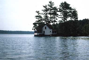
Photo: M. Martin
A. LOCATION
New Hampshire, USA.43:3N, 71:5W; 158 m above sea level.
B. DESCRIPTION
Northwood Lake is a long, narrow, shallow lake located in southeastern New Hampshire, in the town of Northwood, Rockingham County. It is situated approximately 18 miles from Concord, and has 2 miles of shoreline along Route 4, the major east-west highway between the capital city area and the state university, the seashore, and the state of Maine. It is a natural lake raised by damming, having an area of 278 hectares, a mean depth of 2.8 meters, and a maximum depth of 7.3 meters.The lake functions as the final settling basin for several lakes in its 6,226 hectares watershed, prior to its discharge forming the Little Suncook River. The watershed is primarily rural forested and agricultural lands. A large dairy farm and associated corn fields lie along its major tributary Narrows Brook.
Northwood Lake has a free and unencumbered boat launch, a commercial marine, a town beach that is available to non-residents, and a Boy Scout camp. Most of the lake's shoreline is developed, consisting primarily of single family camps and homes. A restaurant and several businesses are located near the lake along Route 4 and a trailer park exists on the shoreline at Northwood Narrows (Q, 3).
C. PHYSICAL DIMENSIONS (1)
| Surface area [km2] | 3 |
| Volume [km3] | 0.0097 |
| Maximum depth [m] | 7.6 |
| Mean depth [m] | 3.7 |
| Water level | Regulated |
| Normal range of annual water | |
| level fluctuation [m] | 1.5 |
| Residence time [yr] | 0.3 |
| Catchment area [km2] | 41 |
D. PHYSIOGRAPHIC FEATURES
D1 GEOGRAPHICAL (1)Bathymetric map: Fig. NAM-36-01.
Number of outflowing rivers and channels (name): 1 (Northwood Lake Outlet).
D2 CLIMATIC (1)
Climatic data at Concord, June 1980-May 1981
Mean temp. [deg C]
| Jan | Feb | Mar | Apr | May | Jun | Jul | Aug | Sep | Oct | Nov | Dec | Ann. |
|---|---|---|---|---|---|---|---|---|---|---|---|---|
| -11 | -1 | 1 | 8 | 14 | 19 | 21 | 19 | 15 | 7 | -2 | -7 | 6.9 |
Solar radiation: 32.5 MJ m-2 day-1.
- Possible Sunshine [% yr-1]
| 1979 | 1980 | 1981 | 1982 |
|---|---|---|---|
| 53 | 59 | 58 | 58 |
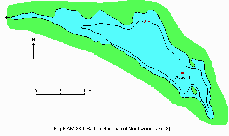 Fig. NAM-36-01
Bathymetric map (2).
Water temperature [deg C] Station 1*, June 1980-May 1981 [m]
| Depth | Jan | Feb | Mar | Apr | May | Jun | Jul | Aug | Sep | Oct | Nov | Dec |
|---|---|---|---|---|---|---|---|---|---|---|---|---|
| 0 | - | - | - | 11.2 | 14.2 | 22.0 | 26.0 | 19.8 | 18.8 | 13.5 | 4.0 | - |
| 1 | - | - | - | 11.1 | 14.2 | 22.0 | 26.0 | 19.8 | 18.8 | 13.5 | 4.0 | - |
| 2 | - | - | - | 11.1 | 14.2 | 20.5 | 26.0 | 19.8 | 18.5 | 13.4 | 4.0 | - |
| 3 | - | - | - | 11.0 | 14.2 | 19.5 | 25.9 | 19.8 | 18.2 | 13.3 | 4.0 | - |
| 4 | - | - | - | 11.0 | 14.2 | 17.5 | 24.2 | 19.7 | 17.9 | 13.3 | 4.0 | - |
| 5 | - | - | - | 11.0 | 14.2 | 17.5 | 22.2 | 19.6 | 17.5 | 13.2 | 4.0 | - |
| 6 | - | - | - | 10.9 | 14.2 | - | - | - | 17.1 | 13.2 | 4.0 | - |
| 6.5 | - | - | - | - | 14.2 | - | - | - | - | 13.1 | 4.0 | - |
Mixing type: Dimictic.
Notes on water mixing and thermocline formation: No stratification observed.
E. LAKE WATER QUALITY (1)
E1 TRANSPARENCY [m]Station 1*, June 1980-May 1981 [m]
| Depth | Jan | Feb | Mar | Apr | May | Jun | Jul | Aug | Sep | Oct | Nov | Dec |
|---|---|---|---|---|---|---|---|---|---|---|---|---|
| - | 2.0 | - | 3.0 | 2.5 | 3.0 | 4.8 | 3.6 | 2.9 | 4.3 | 2.9 | 2.2 |
Station 1, June 1980-May 1981
[m]
| Depth | Jan | Feb | Mar | Apr | May | Jun | Jul | Aug | Sep | Oct | Nov | Dec |
|---|---|---|---|---|---|---|---|---|---|---|---|---|
| 0-1 | 6.2 | 6.4 | - | 6.2 | 6.2 | 6.6 | 6.6 | - | 2.9 | 6.2 | 6.6 | 5.8 |
| 2-3 | 6.0 | 6.2 | - | 6.0 | 6.1 | 6.6 | 6.0 | 4.1 | 6.3 | 6.3 | 6.4 | 5.8 |
| 4-5 | 5.9 | 6.0 | - | 6.0 | 6.1 | 6.4 | 6.3 | 6.3 | 6.2 | 6.3 | 6.4 | 5.7 |
| B* | - | - | - | 6.0 | 6.1 | - | - | 6.3 | 6.3 | 6.4 | - | - |
E3 RESIDUE [mg l-1]
Pleasant Lake Brook, June 1980-May 1981
[m]
| Depth | Jan | Feb | Mar | Apr | May | Jun | Jul | Aug | Sep | Oct | Nov | Dec |
|---|---|---|---|---|---|---|---|---|---|---|---|---|
| 21 | 45 | 35 | 31 | 49 | 62 | 67 | 30 | 95 | 2 | 25 | 51 |
Station 1*, June 1980-May 1981
[m]
| Depth | Jan | Feb | Mar | Apr | May | Jun | Jul | Aug | Sep | Oct | Nov | Dec |
|---|---|---|---|---|---|---|---|---|---|---|---|---|
| 0 | - | - | - | 11.0 | 9.9 | 8.7 | 8.2 | 8.0 | 8.9 | 8.9 | 11.7 | - |
| 1 | - | - | - | 10.9 | 9.8 | 8.6 | 8.2 | 8.1 | 8.9 | 8.9 | 11.7 | - |
| 2 | - | - | - | 10.9 | 9.8 | 8.7 | 8.2 | 8.0 | 8.9 | 8.9 | 11.7 | - |
| 3 | - | - | - | 10.9 | 9.8 | 8.4 | 8.2 | 8.0 | 8.9 | 8.9 | 11.7 | - |
| 4 | - | - | - | 10.9 | 9.8 | 8.2 | 7.4 | 8.0 | 8.7 | 8.8 | 11.7 | - |
| 5 | - | - | - | 10.8 | 9.8 | 7.6 | 6.4 | 7.9 | 8.4 | 8.8 | 11.7 | - |
| 6 | - | - | - | 10.6 | 9.8 | - | - | 7.9 | 8.2 | 8.8 | 11.7 | - |
| 6.5 | - | - | - | 9.8 | - | - | - | - | - | - | - | - |
E6 CHLOROPHYLL CONCENTRATION [micro g l-1]
Station 1*, June 1980-May 1981
[m]
| Jan | Feb | Mar | Apr | May | Jun | Jul | Aug | Sep | Oct | Nov | Dec |
|---|---|---|---|---|---|---|---|---|---|---|---|
| 1.71 | 0.28 | - | 2.33 | 5.32 | 5.14 | 2.54 | 3.42 | 3.71 | 2.82 | 2.21 | 1.90 |
Total-N [mg l-1]
Station 1*1, June 1980-May 1981
[m]
| Jan | Feb | Mar | Apr | May | Jun | Jul | Aug | Sep | Oct | Nov | Dec | |
|---|---|---|---|---|---|---|---|---|---|---|---|---|
| 0-1 | .33 | .66 | - | .36 | .35 | .50 | .27 | - | .33 | .43 | - | .36 |
| 2-3 | .37 | .48 | - | .36 | .40 | .42 | .32 | .25 | .74 | .35 | - | .42 |
| 3-4 | .53 | .48 | - | .35 | .34 | .48 | .27 | .31 | .39 | .28 | - | .40 |
| B*2 | - | - | - | .34 | .31 | - | - | .25 | .40 | .36 | - | - |
Total-P [mg l-1]
Station 1*1, June 1980-May 1981
[m]
| Jan | Feb | Mar | Apr | May | Jun | Jul | Aug | Sep | Oct | Nov | Dec | |
|---|---|---|---|---|---|---|---|---|---|---|---|---|
| 0-1 | .010 | .028 | - | .016 | .015 | .024 | .014 | - | .010 | .009 | .015 | .014 |
| 2-3 | .009 | .020 | - | .016 | .020 | .024 | .013 | .013 | .010 | .009 | .013 | .019 |
| 4-5 | .022 | .032 | - | .018 | .019 | .030 | .013 | .009 | .008 | .009 | .023 | .024 |
| B* | - | - | - | .029 | .018 | - | - | .004 | .009 | .011 | - | - |
F. BIOLOGICAL FEATURES
F1 FLORA (1)Emerged macrophytes
Cephalanthus occidentalis Sagittaria latifolia, Cyperaceae, Sparganium, Typha, Carex, Eriocaulon septangulare, Dulichium arundinaceum, Pontederia cordata, Eleocharis, Phragmites communis, Scirpus.
Floating macrophytes: Nuphar, Nymphaea, Brasenia schreberi.
Submerged macrophytes
Potamogeton, Vallisneria americana, Myriophyllum humile, Utricularia, Nitella.
Phytoplankton
Asterionella, Tabellaria, Anabaena, Lyngbya, Chrysochromulina breviturrita, Mallomonas, Dinobryon, Synura.
F2 FAUNA
Zooplankton (1)
Rotifers (Kellicottia, Keratella, Polyarthra), Crustaceans (Daphnia), Calanoid copepods, Cyclopoid copepods, Nauplius larvae, Cilliates (Tintinnidium).
Fish (4, 5)
Stocked with Morone americana (white perch), Ictalurus natalis (horned pout), Micropterus dolomieui (small mouth bass), Perca flavescens (yellow perch), Notemigonus chrysoleucas (golden shiner), Astacidae, crayfish, Esox niger (eastern chain pickerell), also present Micropterus salmoides (large mouth bass), minnows, suckers, sunfish.
G. SOCIO-ECONOMIC CONDITIONS
G1 LAND USE IN THE CATCHMENT AREA (1)1982
| Area [km2] | [%] | |
|---|---|---|
| Natural landscape | ||
| Forested | ca.26 | 63 |
| Wetland/waterbody | ca. 7 | 16 |
| Open land | <0.5 | |
| Agricultural land | ca. 6 | 14 |
| Residential area | ca. 2 | 6 |
| Others | ||
| Commercial area | <0.5 | |
| Total | 41 | 100 |
Numbers of domestic animals in the catchment area
Cattle <100, horses <25, sheep <10, poultry <10.
G3 POPULATION IN THE CATCHMENT AREA (Q)
1980
| Population | Major cities | ||
|---|---|---|---|
| Population | density [km-2] | (population) | |
| Total | 2,175 | 53.0 | None |
H. LAKE UTILIZATION
H1 LAKE UTILIZATION (Q)Sightseeing and tourism (no. of visitors in 1982: approximately 2,200) and recreation (swimming, yachting, sport-fishing).
I. DETERIORATION OF LAKE ENVIRONMENTS AND HAZARDS (Q)
I1 ENHANCED SILTATIONExtent of damage: Not serious.
I2 TOXIC CONTAMINATION
Present status: None.
Environmental quality standards for contamination in the lake
Toxic concentrations and combinations are evaluated in accordance with EPA's published water quality criteria for 64 toxic substances dated November 1980.
I3 EUTROPHICATION
Nuisance caused by eutrophication
Unusual algal bloom (Chrysochromulina breviturrita) with rotten odor of lake.
Nitrogen and phosphorus loadings to the lake [kg P yr-1]
1981
| Sources | Industrial | Domestic | Agricultural | Natural | Total |
|---|---|---|---|---|---|
| T-P | - | 162.1 | 244.1 | 613 | 1,018.2 |
Extent of damage: Detected but not serious.
J. WASTEWATER TREATMENTS (1)
J1 GENERATION OF POLLUTANTS IN THE CATCHMENT AREA- d) Measurable pollution with limited wastewater treatment.
In June, 1978, Northwood Lake developed into an extremely offensive rotten- cabbage. Samples of lake water revealed an abundance of a small, bi- flagellated organism, later determined to be Chrysochromulina breviturrita. This was a brand new species of algae, not described in the literature until 1978 (Nicolls, 1978). During the investigations of this algal problem, high phosphorus levels (up to 50 mg l-1) were found in runoff from a nearby dairy farm. Prior to this algal bloom, the Water Supply and Pollution Control Commission (WSPCC) had received no other complaints concerning nuisance plant growths in Northwood Lake. However, the following year a shortlived, isolated, Anabaena (blue-green algae) bloom was observed in the Lynn Grove - Pine Point area. A general biological survey of the lake, conducted during the summer of 1979, revealed a shallow mesotrophic lake, with relatively low levels of phosphorus and algae. It appeared that although the lake was still in good shape subtle changes were occurring in the watershed to cause sporadic algal blooms. Because of the rarity of the Chrysochromulina organism, and because of the many unanswered questions concerning the high runoff phosphorus levels and sporadic algal bloom, the State/EPA Agreement for FY 1980 called for a diagnostic/feasibility study of Northwood Lake, to be conducted by the WSPCC and funded partly by the Clean Lakes Program.
J3 SANITARY FACILITIES AND SEWERAGE
Percentage of municipal population in the catchment area provided with adequate sanitary facilities (on-site treatment systems) or public sewerage: 100 septic systems for lake shore communities (90% adequate).
Municipal wastewater treatment systems: None.
K. IMPROVEMENT WORKS IN THE LAKE
K1 RESTORATION (Q)Two applications of copper sulfate in 1978 to reduce the bloom of C. breviturrita.
L. DEVELOPMENT PLANS (Q)
Much of the south side is still available for development and will probably be developed within the next few years.M. LEGISLATIVE AND INSTITUTIONAL MEASURES FOR UPGRADING LAKE ENVIRONMENTS (Q)
M1 NATIONAL AND LOCAL LAWS CONCERNEDNames of the laws
- Federal Water Pollution Control Act Main items of control
- Algae & other aquatic nuisances
- Exotic aquatic weeds
- Illegal dumping & other violations
- Department of Environmental Services, Water Supply and Pollution Control Commisssion, Biology Bureau
N. SOURCES OF DATA
(Q) Questionnaire filled by New Hampshire Water Supply and Pollution
Control
Commission, Concord, New Hampshire.
(1) Towne, R. E. & Estabrook, R. H. (1982) Northwood Lake
Diagnostic/Feasibility
Study. New Hampshire Water Supply and
PollutionControl Commission, Staff Report No. 131.
(2) Classification and Priority Listing of N. H. Lakes Rockingham and
Strafford Counties, Volume 2, Part 6. New
Hampshire Water Supply and
Pollution Control Commission, Staff Report No. 121.
March,1981.
(3) Towne, R. E. & Estabrook, R. H. (1979) A Trophic Study
of Northwood Lake,
Northwood, N. H. New Hampshire Water Supply
and Pollution Control
Commission.
(4) Newell, A. E. (1970) Biological Survey of the Lakes and Ponds
in
Cheshire, Hillsborough and Rockingham Counties.
State of New Hampshire
Fish and Game Department, Survey Report No. 8C.
(5) Scarola, J. F. (1973) Freshwater Fishes of New Hampshire.New
Hampshire
Fish and Game Department, Division of Inland and
Marine Fisheries.
N. SOURCES OF DATA
(Q) Questionnaire filled by New Hampshire Water Supply and Pollution
Control
Commission, Concord, New Hampshire.
(1) Towne, R. E. & Estabrook, R. H. (1982) Northwood Lake
Diagnostic/Feasibility Study. New Hampshire
Water Supply and Pollution
Control Commission, Staff Report No. 131.
(2) Classification and Priority Listing of N. H. Lakes, Rockingham
and
Strafford Counties, Volume 2, Part 6. New
Hampshire WaterSupply and
Pollution Control Commission, Staff Report No. 121.
March,1981.
(3) Towne, R. E. & Estabrook, R. H. (1979) A Trophic Study
of Northwood Lake,
Northwood, N. H. New Hampshire Water Supply
and Pollution Control
Commission.
(4) Newell, A. E. (1970) Biological Survey of the Lakes and Ponds
in
Cheshire, Hillsborough and Rockingham Counties.
State of New Hampshire
Fish and Game Department, Survey Report No. 8C.
(5) Scarola, J. F. (1973) Freshwater Fishes of New Hampshire.New
Hampshire
Fish and Game Department, Division of Inland and
Marine Fisheries.
