
WESTERN BROOK POND
A view on the lake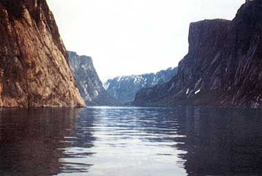
Photo: J. Kerekes
A. LOCATION
Newfoundland, Canada.49:4N, 57:6W; 30 m above sea level.
B. DESCRIPTION
The ultraoligotrophic Western Brook Pond in Gros Morne National Park is a fjord lake which, after the retreat of the ice and the rebound of the land, became separated from the sea. It is accessible by a foot trail of about 4.8 km from the main road along the seashore. Although more than 60% of the lake's volume is below sea level, its water is entirely fresh. The scenic grandeur of Western Brook Pond is overwhelming. It is certainly among the most grandiose lakes in Canada's National Parks. The wide western end of the lake is surrounded by relatively flat, low-lying land. In the gorge where the lake narrows and the topography rises suddenly, the lake is confined by steep rock walls 600 m high. The sudden change in elevation often contributes to sudden atmospheric turbulences and strong shifting winds which make the lake very hazardous for small crafts. The lake was first surveyed in 1972 with the formation of Gros Morne National Park. Prior to that, only the occasional local person visited the lake. It is now a popular destination for park visitors for hiking, sightseeing and taking a cruise on a small tour boat.The catchment basin is 7.4 times the size of the lake surface area. The lake receives drainage from more than 20 streams. The majority of these streams fall down or cascade from the highland plateau, draining areas lying over igneous rocks with poorly developed soils. These waters are very dilute, low in calcium, and pH is around 5.5. By contrast, the largest inflow, Stag Brook, at the western end of the lake, carries drainage from sedimentary rocks with higher calcium and pH. The frequent atmospheric turbulences keep the water mass well mixed along the length of the lake basin which is sufficient to maintain near circumneutral pH in the lake.
The lake water is very clear, with values of close to 5 Hazen units, but it may reach 10 Hazen units near the surface owing to the dispersion of coloured water from some of the inflows.
The productivity of the lake is extremely low which is well reflected in the hypolimnetic oxygen depletion rate. The oxygen concentration remains very high throughout the water column during stratification period and the depletion of oxygen is almost unmeasurable. Taking differences in water temperature into account and expressing dissolved oxygen as percent air saturation, the water column remains supersaturated from the surface to the bottom (165 m) at the end of summer with dissolved oxygen concentration higher near the bottom than at the surface.
The lake supports Atlantic salmon (Salmo salar)(both land locked and anadromous) and land locked arctic charr (Salvelinus alpinus). The lake was frequented by small groups of anglers in the 1970's, but after a few years of angling, the catches greatly declined. The lake is now closed to angling.
C. PHYSICAL DIMENSIONS (Q)
| Surface area [km2] | 23 |
| Volume [km3] | 1.65 |
| Maximum depth [m] | 165 |
| Mean depth [m] | 72.5 |
| Water level | Unregulated |
| Length of shoreline [km] | 42.5 |
| Residence time [yr] | 15.4 |
| Catchment area [km2] | 171 |
D. PHYSIOGRAPHIC FEATURES
D1 GEOGRAPHICALSketch map: Fig. NAM-31-0l.
Bathymetric map: Fig. NAM-31-02.
Names of main islands: The area of island is 0.023 km2.
Number of outflowing rivers and channels (name): 1 (Western Brook).
D2 CLIMATIC
Climatic data at Rocky Harbour*, 1987 (7)
Mean temp. [deg C]
| Jan | Feb | Mar | Apr | May | Jun | Jul | Aug | Sep | Oct | Nov | Dec | Ann. |
|---|---|---|---|---|---|---|---|---|---|---|---|---|
| -9.1 | -6.4 | -4.9 | 3.7 | 6.5 | 11.5 | 16.4 | 15.3 | 11.7 | 8.1 | 0.6 | -3.5 | 4.2 |
| Jan | Feb | Mar | Apr | May | Jun | Jul | Aug | Sep | Oct | Nov | Dec | Ann. |
|---|---|---|---|---|---|---|---|---|---|---|---|---|
| 106 | 100 | 26 | 72 | 51 | 78 | 33 | 82 | 167 | 160 | 115 | 115 | 1,104 |
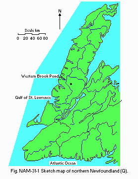
Sketch map of northern Newfoundland (Q).
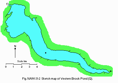
Bathymetric map [m](Q).
Number of hours of bright sunshine (Stephenville A*): 1,432 hr yr-1
(2).
* 148 km distance from the lake.
Solar radiation (St. John's West CDA*)[MJ m-2 day-1]
| Jan | Feb | Mar | Apr | May | Jun | Jul | Aug | Sep | Oct | Nov | Dec | Ann. |
|---|---|---|---|---|---|---|---|---|---|---|---|---|
| 4.14 | 7.08 | 10.42 | 13.60 | 16.54 | 19.60 | 19.94 | 15.72 | 12.02 | 6.82 | 4.11 | 3.03 | 11.1 |
1972, 1982 and 1973
| [m] | 1972 | 1982 | 1973 | |
|---|---|---|---|---|
| Depth | 26 Jul | 10 Aug | 8 Sep | 11 Dec |
| 0 | 13.0 | 13.2 | 12.0 | 5.05 |
| 10 | 12.2 | 12.9 | 12.0 | 5.05 |
| 20 | 10.6 | 12.3 | 11.5 | 5.05 |
| 40 | 7.7 | 7.4 | 9.5 | 5.05 |
| 60 | 5.7 | 5.8 | 6.5 | 5.05 |
| 90 | 4.9 | 5.0 | 5.0 | 5.05 |
| 120 | 4.7 | 4.7 | 4.5 | 5.05 |
| 150 | 4.6 | 4.5 | 4.5 | 5.05 |
Februaty-March (very variable and not freeze over in some years).
Mixing type: Dimictic.
E. LAKE WATER QUALITY
E1 TRANSPARENCY [m](5) Deep station, 1972| [m] | |||
|---|---|---|---|
| Depth | Aug | Sep | Dec |
| 10.0 | 6.5 | 9.8 |
| Depth | Jul | Aug | Sep | Dec |
|---|---|---|---|---|
| 0 | 7.4 | 7.05 | 6.7 | 6.94 |
| 10 | 7.6 | 7.0 | - | - |
| 20 | 7.3 | - | - | - |
| 30 | 7.2 | - | - | - |
| 40 | 7.4 | - | - | - |
| 100 | 7.0 | 6.9 | 6.8 | 6.90 |
| 150 | 7.2 | 6.9 | 6.6 | - |
Extremely low.
E4 DO [mg l-1](5)
Deep Station, 1973
| [m] | |
|---|---|
| Depth | Aug |
| 0 | 10.0 |
| 20 | 10.4 |
| 30 | 10.4 |
| 50 | 12.3 |
| 70 | 12.5 |
| 90 | 12.6 |
| 120 | 12.7 |
| 150 | 12.8 |
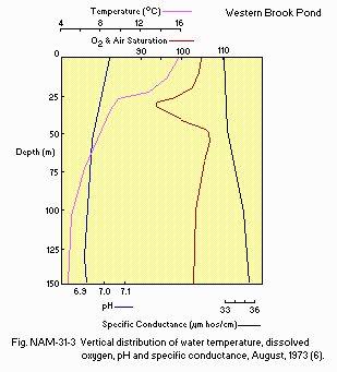
Vertical distribution of water temperature, dissolved oxygen, pH and specific conductance, August 1973 (6).
E6 CHLOROPHYLL CONCENTRATION(5)
Chlorophyll a [micro g l-1]
Deep Station, 1973
| [m] | |||
|---|---|---|---|
| Depth | Jul | Aug | Dec |
| 0 | 0.4 | 0.8 | 0.3 |
| 5 | 0.4 | - | - |
| 10 | 0.4 | 0.6 | 0.3 |
| 20 | 0.4 | 0.2 | 0.3 |
| 30 | 0.2 | 0.2 | 0.3 |
| 40 | 0.2 | 0.1 | 0.3 |
Total-P [mg l-1]
Deep Station, 1972
| [m] | |||
|---|---|---|---|
| Depth | Jul | Aug | Dec |
| 0 | 2.5 | 3.1 | 1.9 |
| 30 | - | 1.6 | - |
| 100 | 1.9 | 1.6 | 1.9 |
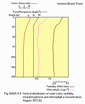
Vertical distribution of water color, turbidity, total phosphorus and chlorophyll a concentration, August 1973 (6).
E9 CHLORIDE CONCENTRATION [mg l-1](6)
Deep Station, 26 July 1972
| [m] | |
|---|---|
| Depth | Jul |
| S* | 4.8 |
F. BIOLOGICAL FEATURES (6)
F1 FLORAEmerged macrophytes: Typha latifolia, Scirpus validus.
Floating macrophytes: Nuphar variegatum.
Submerged macrophytes: Potamogeton richardsonii.
F2 FAUNA
Zooplankton
Kellicottia sp., Gastropus sp., Asplanchna sp., Polyarthra sp., Hexarthra sp., Conochilus sp., Holopedium gibberum, Eurosimina sp., Epichura lacustris, Diaptomus sp., D. minutus.
Benthos
List of benthic fauna obtained by a 232 cm2 Eckman dredge in 1973 (6).
| Date | No.of | Depth | Organism | No.of |
|---|---|---|---|---|
| 1973 | grabs | [m] | individuals | |
| 8/9 | 3 | 3 | Chironomidae | |
| Prodiamesa sp. | 1 | |||
| Chironomus sp. | 12 | |||
| Stictochironomus sp. | 16 | |||
| Parametriocnemus sp. | 2 | |||
| Tanytarsus sp. | 7 | |||
| Hirudinea | ||||
| Helobdella sp. | 6 | |||
| Mollusca | ||||
| Sphaeridae too soft to identify | ||||
| Trichoptera | ||||
| Drusinus sp. | 1 | |||
| Oligochaeta | ||||
| Lumbriculus sp. | 17 | |||
| 8/16 | 1 | 158 | Nematoda | 2 |
| Chironomidae | ||||
| Harnischia sp. | 1 | |||
| Terrestrial insects | 21 |
Salmo salar, Salvelinus fontinalis, S. alpinus, Gasterosteus aculeatus, Anguilla rostrata.
F7 NOTES ON THE REMARKABLE CHANGES OF BIOTA IN THE LAKE IN RECENT YEARS
In the 70's the angling catches decreased greatly and the lake is now closed to angling.
G. SOCIO-ECONOMIC CONDITIONS
G1 LAND USE IN THE CATCHMENT AREA1976
The lake and its catchment is in Gros Morne National Park. A large portion of its catchment is non-forested tundra on high plateau.
G2 INDUSTRIES IN THE CATCHMENT AREA AND THE LAKE
1988: None.
G3 POPULATION IN THE CATCHMENT AREA
1988: None.
H. LAKE UTILIZATION
H1 LAKE UTILIZATIONSource of water, sightseeing and tourism (no. of visitors 2 June to 3 Octorber in 1988: 9,200).
I. DETERIORATION OF LAKE ENVIRONMENTS AND HAZARDS
I1 ENHANCED SILTATIONExtent of damage: None. I2 TOXIC CONTAMINATION
Present status: None.
I3 EUTROPHICATION
Nuisance caused by eutrophication: None.
Nitrogen and phosphorus loadings to the lake (6)
1973: 77.1 [mg P m-2 yr-1](from natural sources).
I4 ACIDIFICATION
Extent of damage: Detected but not serious.
Supplementary notes
The drainage basin receives 10 - 15 kg ha yr-1 wet excess SO4 deposition which is causing depressed pH levels in the inflows (very low in calcium concentration), draining catchments lying over igneous rocks on the highland plateau. By contrast inflows at low elevation, such as Stag Brook (Ca 6.1 mg l-1, pH 7.4) drain soils lying over sedimentary rock formation. The frequent strong winds mix well the lake water resulting in relatively high concentration of calcium (2.2 mg 1-1) and near circumneutral pH along the length of the lake. A regular monitoring program of sampling of surface waters in lakes on the highland plateau is conducted by Environment Canada. Other federal agencies may conduct monitoring at the request or in cooperation with the Canadian Parks Service.
J. WASTEWATER TREATMENTS
J1 GENERATION OF POLLUTANTS IN THE CATCHMENT AREA- a) Pristine lake environments.
| [%] | |
|---|---|
| Non-point sources | |
| (natural) | 100% |
| Total | 100% |
L. DEVELOPMENT PLANS
The only existing development is a tour boat service to carry approximately 30 persons at a time. A modest well controlled expansion of the boat service is planned with the construction of a small docking facility at the western end of the lake. A foot trail to encircle the lake, leading to the high plateau, is planned. The lake has only foot access and the construction of vehicle access is not contemplated. The Canadian Parks Service intends to maintain the pristine character of Western Brook Pond.M. LEGISLATIVE AND INSTITUTIONAL MEASURES FOR UPGRADING LAKE ENVIRONMENTS (Q)
M1 NATIONAL AND LOCAL LAWS CONCERNED Names of the laws (the year of legislation)- National Parks Act (1930, last amendment C48 in 1988)
- Gros Morne National Park is designated as a World Heritage Site Responsible authorities
- Canadian Parks Service
- UNESCO designation at the recommendation of the Canadian Government Main items of control
- Canadian Parks Service controls access and all development on the basin of Western Brook Pond which is entirely within the boundaries of Gros Morne National Park.
- Gros Morne National Park, Rocky Harbour, Newfoundland
N. SOURCES OF DATA
- Questionnaire filled by Dr. J. Kerekes, Canadian Wildlife Service, Bedford Institute of Oceanography, Dartmouth, N. S.
- Dadswell, M. J. (1970) A Physical and Biological Survey of the Aquatic Environment (Fresh-water) of the Proposed Gros Morne National Park, Newfoundland. Canadian Wildlife Service Ms. Report. 76 pp.
- Canadian Climate Normals, 1951-1980. Environment Canada, Atmospheric Environment Service.
- Kerekes, J. & Schwinghamer, P. (1975) Lake Drainage and Morphometry. Aquatic Re. sources Inventory, Gros Morne National Park, Nfld. Can. Wildlife Service Ms. Report. 155 pp.
- Kerekes, J. & Schwinghamer, P. (1975) Hydrographic Maps, Area and Volume Curves. Aquatic Resources Inventory, Gros Morne National Park, Nfld. Canadian Wildlife Service Ms. Report. 101 pp.
- Kerekes, J. & Schwinghamer, P. (1975) Selected Limnological Measurements in 43 lakes and 72 streams. Aquatic Resources Inventory, Gros Morne National Park, Nfld. Canadian Wildlife Service Ms. Report. 44 pp.
- Kerekes, J. (1978) Limnological Conditions. Aquatic Resources Inventory, Gros Morne National Park, Nfld. Canadian Wildlife Service Ms. Report. 155 pp.
- Gros Morne National Park (1989) Unpublished data.
