
GREAT BEAR LAKE
A view of Mc tavish Arm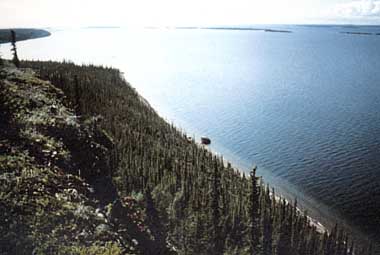
Photo: L. Johson
A. LOCATION
Northwest Territories, Canada.65:0-67:0N, 118:0-123:0W; 186 m above sea level.
B. DESCRIPTION
Located on the Arctic Circle (66¡¦0'N), Great Bear Lake is the largest lake within the borders of Canada. With its almost equally large companion, Great Slave Lake, and their combined drainage, the Mackenzie River, this water system completely dominates the geography of the Mackenzie District of the Northwest Territories.Great Bear Lake lies across the junction between two major physiographic regions: the Kazan portion of the Canadian Shield and the Interior Plains (1). Originally formed by the broadening and deepening of preglacial valleys by erosional effects of ice during the Pleistocene (2), the lake has subsequently been altered by changes in the land form resulting from rebound following melting of the ice.
Precambrian rocks of the Shield form the eastern margin of McTavish Arm (3). This region of the lake has magnificent scenery amongst the many islands and long fjord-like indentations of the coastline. The complex rocks of the Precambrian are made up of sedimentary and metamorphic deposits supplemented by igneous intrusions forming dykes and sills (4, 5, 6, 7). Between the Shield and the Interior Plains region which forms most of the western shoreline, there is a narrow band of Ordovician rocks composed of limestone and dolomite with sandstone and conglomerate inclusions (8). The Great Bear Plain (8, 9) is largely composed of glacial till underlain with Mesozoic strata of undivided limestone. The terrain in this region is gently rolling, generally below 300 m in elevation with occasional hills such as Grizzley Bear Mountain or the Scented Grass Hills reaching an elevation of 450 m.
At the height of the most recent glaciation the majority of the land to the east of the Mackenzie River was covered by the Laurentide ice-sheet, but an unglaciated region is known to have existed to the west of Great Bear Lake along the front dividing the Laurentide from the Cordilleran ice-sheets (10). About 10,000 years B. P. the ice-margin approximately coincided with the Shield boundary (11). The ice-sheet crossed the basic northward slope of the land blocking drainage thus giving rise to the very large proglacial lake, Glacial Lake McConnell, covering the area now occupied by both Great Bear and Great Slave Lakes and the land between them (12, 13). This immense lake drained to the south-east; its strand-lines, still visible 145 m above the present level of Great Bear Lake, attest to its original size. With the retreat of the ice the land rebounded unequally causing a noticeable tilt to the strand-lines and the formation of an outlet at the western end of what is now Smith Arm. As the land surface continued to change the outlet switched from this region to its present location at the western end of Keith Arm. Archaeological evidence suggests this outlet was established by about 4000 B. P., some 12 m above the present lake level. Further archaeological evidence indicates that the present lake level had been established by about 2600 years B. P. (14, 15).
At the present time Great Bear Lake occupies a position close to the northern limit of trees. To the south and west are forests, largely of black and white spruce interspersed with muskeg in the lower-lying poorly drained regions. To the north the forest declines giving way to tundra with trees in the more sheltered areas only.
In Pre-European times the area was occupied by various Indian tribes of the Athapascan language group: the Hares on the north-western shore, Slaveys and Mountain people in the vicinity of Bear River, Dogribs along the southern- eastern shores and Copper Indians in the east, together making up a group recognised as the Satudene (15, 16). The northern shores of the lake were occasionally visited by the Inuit on hunting forays from the Coronation Gulf region.
The first European penetration was the establishment of a fur-trading post by the Northwest Fur Company in 1799 (17, 18). Initial geological investigations in the region were carried out in 1898 by Dr. J. Mackintosh Bell and Charles Camsell (19). They noted the possibility of valuable metal ores on the eastern shores of McTavish Arm (19). In 1903 E. A. Preble entered the region via the Camsell River, a route pioneered by Charles Camsell a year or two earlier (20). Preble (21) collected birds and fishes along the south sides of MCTavish and Keith Arms, adding considerably to the natural history of the region. In 1930 Gilbert LaBine staked claims for silver and cobalt at Echo Bay. A mine was established but it was found that the associated pitchblende deposits had the relatively high radium content of 1 g/6.5 tons of ore (22). The uranium ore was discarded as of little commercial value. With the advance of physics the demand for radium declined, production became unprofitable and the mine was closed in 1940. However, the mine was re-opened in 1942 by Eldorado Mining and Refining Company to supply uranium for the Manhatten Project. Quantities of uranium were to be found in the tailings from the radium extraction process which, having previously been dumped in the lake, were recovered by dredging. This mine was closed in 1964 but certain workings were maintained for the extraction of silver by Echo Bay Mines Ltd.
The first biological survey of the lake, sponsored by the Fisheries Research Board of Canada, was carried out by Miller and Kennedy in 1945 (23, 24, 25). Thereafter, between 1963 and 1965 the Fisheries Research Board carried out a more detailed biological and limnological survey (26, 27, 28). This three- year programme utilized the former mine tugboat M. V. Radium Gilbert as the survey ship. The relatively large size of this vessel enabled a bathymetric survey to be made as well as detailed investigations of temperature structure in the deepest regions. Investigations that have had a bearing on the lake circulation and theoretical aspects of the temperature of maximum density of fresh water with increasing pressure (29, 30). Observations on fish, plankton and benthos distribution and density also were made.
The northerly latitude of Great Bear Lake, combined with its great volume and immense heat budget (40,600 cal cm-2)(26), ensure that it has many of the characteristics of a polar lake although in a northern continental setting. This appears to account for anomalies with respect to the fish species complement. Despite the general correlation between increasing lake size and increasing species richness (32) when the effect of latitude is removed, Great Bear Lake exhibits the opposite effect: fewer species in the lake than might be expected and fewer species in the lake than exist within the drainage basin as a whole. This is manifest in several ways: 1) all species except lake trout Salvelinus namaycush and deep-water sculpin Myoxocephalus quadricornis are confined to the warmer shallower more secluded bays, 2) certain species occurring both upstream and downstream of the lake do not occur in the lake itself (lake chub Couesius plumbeus and troutperch Percopsis omiscomaycus) and 3) other species occur in only very limited locations (walleye Stizostedion vitreum or at very small size (relative to neighbouring lakes) and at very few locations (burbot Lota lota). This is a very clear-cut case of environmental exclusion.
C. PHYSICAL DIMENSIONS (26, 34)
| Surface area [km2] | 31,153 |
| Volume [km3] | 2,236 |
| Maximum depth [m] | 446 |
| Mean depth [m] | 71.7 |
| Water level | Unregulated |
| Normal range of annual water | |
| level fluctuation [m] | 0.2-0.3 |
| Length of shoreline [km] | 2,719* |
| Residence time [yr] | 124 |
| Catchment area [km2] | 114,717 |
D. PHYSIOGRAPHIC FEATURES
D1 GEOGRAPHICALSketch map: Fig. NAM-30-01.
Bathymetric map: Fig. NAM-30-02.
Names of main islands (26)
| Area [km2] | ||
|---|---|---|
| McTavish Arm: | Achook | |
| Cornwall | ||
| Broadway | ||
| Hogarth | 432.3 | |
| Stevens | ||
| Workman | ||
| Richardson | ||
| Superstition | ||
| McVicar Arm: | Unnamed | 73.5 |
| Keith Arm: | George | |
| Lionel | 4.0 | |
| Smith Arm: | Ikanyo | |
| Ekka | ||
| Kroger | 135.1 | |
| Crosswise | ||
| Dease Arm: | Rich | |
| Prospect | 114.4 | |
| Narakay Island | ||
| Total area | 759.3 |
D2 CLIMATIC
Climatic data at Port Radium, 1950-1974 (35)
Mean temp. [deg C]
| Jan | Feb | Mar | Apr | May | Jun | Jul | Aug | Sep | Oct | Nov | Dec | Ann. |
|---|---|---|---|---|---|---|---|---|---|---|---|---|
| -27 | -27 | -19.1 | -10.7 | 1.2 | 9.0 | 12.0 | 10.6 | 5.3 | -3.2 | -14.8 | -23 | -7.2 |
| Jan | Feb | Mar | Apr | May | Jun | Jul | Aug | Sep | Oct | Nov | Dec | Ann. |
|---|---|---|---|---|---|---|---|---|---|---|---|---|
| 11 | 8 | 14 | 6 | 14 | 14 | 35 | 43 | 25 | 27 | 25 | 14 | 236 |
| End |
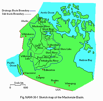
Sketch map of the MacKenzie Basin.
Number of hours of bright sunshine (Norman Wells): 1,854* hr yr-1. * 40% of total possible. Solar radiation (Cambridge Bay A)[MJ m-2 day-1](35)
| Jan | Feb | Mar | Apr | May | Jun | Jul | Aug | Sep | Oct | Nov | Dec | Ann. |
|---|---|---|---|---|---|---|---|---|---|---|---|---|
| 0.19 | 1.82 | 7.57 | 16.03 | 21.76 | 23.16 | 18.54 | 11.97 | 6.20 | 2.85 | 0.39 | - | 10 |
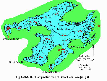
Bathymetric map [m](Q).
Water temperature [deg C](26, 29, 30)
Six miles west of Port Radium, 1964-1965
| [m] | 1964 | [m] | 1965 | |||||
|---|---|---|---|---|---|---|---|---|
| Depth | Jul*1 | Jul*2 | Aug*3 | Aug*4 | Depth | Apr*5 | Aug*6 | Aug*7 |
| 0 | 2.36 | 3.00 | 3.77 | 5.22 | 0 | ice | 2.75 | 3.54 |
| 3 | 2.92 | 2 | 0.04 | |||||
| 5 | 2.92 | 5 | 0.04 | |||||
| 10 | 2.93 | 4.30 | 10 | 0.04 | 2.68 | |||
| 19 | 3.71 | |||||||
| 20 | 4.26 | 20 | 0.06 | 2.64 | ||||
| 30 | 2.90 | 30 | 0.18 | |||||
| 48 | 3.65 | 49 | 3.42 | |||||
| 50 | 2.33 | 4.12 | 50 | 1.37 | 2.68 | |||
| 99 | 3.41 | |||||||
| 100 | 3.02 | 3.03 | 3.93 | 100 | 2.91 | 2.66 | ||
| 106 | 3.64 | 148 | 3.43 | |||||
| 123 | 3.52 | |||||||
| 150 | 3.37 | 3.57 | 3.87 | 150 | 3.50 | 2.67 | ||
| 155 | 3.65 | |||||||
| 188 | 3.64 | |||||||
| 200 | 3.63 | 3.87 | 200 | 3.53 | 3.55 | |||
| 201 | 3.63 | |||||||
| 230 | 3.59 | 246 | 3.42 | |||||
| 250 | 3.62 | 3.62 | 250 | 3.53 | 3.55 | |||
| 280 | 3.61 | 3.60 | ||||||
| 299 | 3.59 | 295 | 3.43 | |||||
| 300 | 3.57 | 3.59 | 300 | 3.51 | 3.53 | |||
| 317 | 3.57 | |||||||
| 328 | 3.57 | |||||||
| 347 | 3.57 | |||||||
| 350 | 3.59 | 350 | 3.52 | 3.55 | ||||
| 396 | 3.56 | 390 | 3.52 | |||||
| 398 | 3.56 | |||||||
| 400 | 3.56 | 3.58 | 400 | 3.51 |
Mixing type: Monomictic.
Notes on water mixing and thermocline formation
Complete circulation only occurs intermittently (1 year in three of observation) when heating is slow. In other years circulation only occurs in upper 200-250 m.
E. LAKE WATER QUALITY
E1 TRANSPARENCY [m](26)A station*, August 1963-1965: 30.
Bear's Bottom, August 1963-1965: 27-29.
McVicar Arm, August 1963-1965: 10 (maximum reading).
* 35 km west of Port Radium (66¡¦0'N, 118¡¦9'W) in a water depth of 200 m.
E2 pH (26) All readings in the lake fall between 7.8 and 8.1.
E4 DO [mg l-1](26) Bear's Bottom, 1964
[m]
| Depth | 22 Jul | 11 Aug | 27 Aug |
|---|---|---|---|
| 0 | 14.05 | 13.4 | 13.21 |
| 3 | 14.31 | 13.35 | - |
| 10 | 14.17 | 13.27 | 14.0 |
| 100 | 14.03 | 13.32 | 13.4 |
| 200 | 13.25 | 12.83 | 13.73 |
| 300 | 13.05 | 12.79 | 13.48 |
| 350 | 12.05 | 12.72 | 13.05 |
| 400 | 12.27 | 12.40 | 12.78 |
Total-N [mg l-1]
Bear's Bottom, 1963-1964
[m]
| Depth | Jan | Feb | Mar | Apr | May | Jun | Jul | Aug | Sep | Oct | Nov | Dec |
|---|---|---|---|---|---|---|---|---|---|---|---|---|
| 0 | - | - | - | - | - | - | - | 0.49 | - | - | - | - |
Total-P [mg l-1]
Bear's Bottom, 1963-1964; samples filtered in the field and analysed 2-3 months later. Most samples showed no measurable phosphate. Maximum values: <0.1 mg l-1.
F. BIOLOGICAL FEATURES
F1 FLORAEmerged macrophytes
There is little emergent vegetation along the shorelines on account of ice- scour. In the most secluded bays there are stands of Equisetum (list incomplete).
Submerged macrophytes: Hippuris vulgaris (list incomplete).
F2 FAUNA
Zooplankton (27)
Limnocalanus macruras, Senecella calanoides, Diaptomus sicilis, Cyclops scutifer, C. vernalis, Daphinia middendorffiana, D. longispina hyalina var. microcephala, Bosmina longirostris, Leptodora kindtii, Epischura nevadensis.
Fish
Salvelinus namaycush*, Coregonus clupeaformis*, C. artedii, Porsopium cylindraceum, Stizostedion vitueum, Esox lucius, Catostomus catostomus, Thymallus arcticus, Myoxocephalus quadricornis thompsonii, Cottus cognatus, Pungitius pungitius (23, 24, 25, 27, 28)(*economically important). Also taken: Oncorhynchus keta, O. kisutch (one specimen only), Salvelinus malma.
Benthos (27)
<10 m (Gammarus lacustris, Pontoporeia affinis, Hyalella azteca, Valvata cincerahelicoidea, Gyraulus deflectus, Lymnea elodes, Sphaerium nitidum, Pisidium idahoensis, P. casertanum, P. lilljeborgi; Mysis relicta), >10 m (Pontoporeia affinis, Mysis relicta, Myoxocephalus quadricornis), >100 m (Myoxocephalus quadricornis, Hydra sp., Mysis relicta (rare)).
F4 BIOMASS
Zooplankton* [no m-2]
August-September 1964-1965
167,000 (38,000-471,000)
* In the different arms.
F5 FISHERY PRODUCTS
Annual fish catch [metric tons]
1988
Sport-catch: 20.
Native domestic fishery: 15.
G. SOCIO-ECONOMIC CONDITIONS
G1 LAND USE IN THE CATCHMENT AREATypes of important forest or scrub vegetation
Coniferous forest, largely Picea glauca, P. mariana and Pinus banksiana.
Types of the other important vegetation: Tundra and muskeg swamp.
Main kinds of crops and/or cropping systems: None.
G2 INDUSTRIES IN THE CATCHMENT AREA AND THE LAKE 1988
| Gross | No. of | No. of | Main products or | |
|---|---|---|---|---|
| product | persons | establish- | major industries | |
| per year | engaged | ments | ||
| (US$) | ||||
| Primary industry | ||||
| Fisheries (sport) | 5 million | 300 | 5 | Trophy-sized lake |
| trout | ||||
| Secondary industry | Silver mine now | |||
| closed |
| Population | Major cities | ||
|---|---|---|---|
| Population | density [km-2] | (population) | |
| Rural | 700* | ||
| Total | 700 | 0-19 | None |
H. LAKE UTILIZATION
H1 LAKE UTILIZATION (31)Source of water, recreation (sport-fishing, yachting) and fisheries (limited domestic fishery).
H2 THE LAKE AS WATER RESOURCES
1988
Domestic water use: Negligible.
I. DETERIORATION OF LAKE ENVIRONMENTS AND HAZARDS
I1 ENHANCED SILTATION- Extent of damage: None.
- Present status: None.
- Extent of damage: None.
J. WASTEWATER TREATMENTS
J1 GENERATION OF POLLUTANTS IN THE CATCHMENT AREA- a) Pristine lake environments.
K. IMPROVEMENT WORKS IN THE LAKE
None.L. DEVELOPMENT PLANS
None.M. LEGISLATIVE AND INSTITUTIONAL MEASURES FOR UPGRADING LAKE ENVIRONMENTS (Q)
M1 NATIONAL AND LOCAL LAWS CONCERNED- Names of the laws (the year of legislation)
- Fisheries Act (1970)
- Northwest Territories Fishing Regulations (1978) (Both act and regulations updated annually.)
- Responsible authorities
- Department of Fisheries and Oceans, Ottawa
- Great Bear Lake Management Committee (1986)
- Freshwater Institute, Department of Fisheries and Oceans, Winnipeg (active research on fish stocks only)
N. SOURCES OF DATA
- Questionnaire filled by Dr. L. Johnson, Canada Department of Fisheries and Oceans, Freshwater Institute, Winnipeg, Manitoba.
- Bostock, H. S. (1970) Physiographic regions of Canada. "Geology and Economic Minerals of Canada" (ed. Douglas, R. J. W.), pp. 9-30. Department of Energy, Mines and Resources, Ottawa.
- Flint, R. F. (1971) Glacial and Quaternary Geology. Wiley, New York. 892 pp.
- Douglas, R. J. W. (1968) Geological Map of Canada no. 1250A, 1:500,000. Geological Survey, Department of Energy, Mines and Resources, Ottawa.
- Kidd, D. F. (1932a) Great Bear Lake-Coppermine River area. Can. Min. Metall. Bull., 245: 512-526.
- Kidd, D. F. (1932b) Great Bear Lake-Coppermine River area, Mackenzie District, Northwest Territories. Can. Geol. Surv. Summ. Rep. 1931, 47-69.
- Kidd, D. F. (1932c) The Great Bear Lake-Coppermine River district. Can. Min. J., 53: 5-12.
- Kidd, D. F. (1933) Great Bear Lake area, Northwest Territories. Can. Geol. Surv. Summ. Rep. 1932: 1-36.
- Douglas, R. J. W. Physiographic regions of Canada. "Geology and Economic Minerals of Canada, Vol. II, Maps and Charts". Geological Survey, Department of Energy, Mines and Resources, Ottawa.
- Douglas, R. J. W., Norris, D. K., Thorsteinson, R. & Tozer, E. T. (1963) Geology and Petroleum Potentialities of Northern Canada. Can. Geol. Surv. Paper 63-31. 28 pp.
- Prest, V. K., Grand, D. R. & Rampton, V. N. (1967) Glacial Map of Canada. Geological Survey, Department of Energy, Mines and Resources, Ottawa.
- Bird, J. B. (1967) The Physiography of Arctic Canada. 336 pp. Johns Hopkins, Baltimore.
- Craig, B. D. (1965) Glacial Lake McConnell and the Surficial Geology of Parts of the Slave and Redstone Rivers Map Area, District of Mackenzie. Geol. Surv. Can. Bull. 122. 33 pp.
- Craig, B. G. & Fyles, J. G. (1960) Pleistocene Geology of Arctic Canada. Geol. Surv. Can. Pap. 60-10. 21 pp.
- McNeish, S. S. (1964) Two archaeological sites on Great Bear Lake, N. W. T., Canada. American Antiquity, 19: 234-253.
- Clark, D. W. (1987) Archaeological Survey of Canada. Paper 136. National Museum, Ottawa.
- Morris, M. W. (1972) Great Bear Lake Indians: a historical and human ecology. Musk-ox, 11: 3-17.
- Franklin, J. (1828) Extracts from Franklin's Second Journey to the Polar Sea in the Years 1825, 1826 and 1827. 320 pp. John Murray, London.
- Johnson, L. (1976) The Great Bear Lake: its place in history. Arctic, 28: 230-244.
- Bell, J. M. (1902) Report on the Topography and Geology of Great Bear Lake and a Chain of Lakes and Streams thence to Great Slave Lake. Canada Geological Survey, Annual Report 1899. S. E. Dawson, Ottawa.
- Camsell, C. (1937) Great Bear Lake exploration. Can. Geog. J., 14: 126- 151.
- Preble, E. A. (1908) A Biological Investigation of the Mackenzie- Athabasca Region. U.S. Department of Agriculture (North American Fauna, no. 27), Washington, D. C.
- Eldorado Mining and Refining Co. (1967) "Annual Report." Port Hope, Ontario.
- Miller, R. B. (1947) Great Bear Lake. "Northwest Can. Fish. Surv. 1944- 45" (Bull. Fish. Res. Board Can. 72), pp. 31-44.
- Miller, R. B. & Kennedy, W. A. (1948) Observations on the lake trout of Great Bear Lake. J. Fish. Res. Board Can., 7: 176-189.
- Kennedy W. A. (1949) Some Observations on the Coregonine Fish of Great Bear Lake, N. W. T. Bull. Fish. Res. Board Can. 82. 10 pp.
- Johnson, L. (1975a) Physical and chemical characteristics of Great Bear Lake. J. Fish. Res. Board Can., 32: 1971-1987.
- Johnson, L. (1975b) Distribution of fish species in Great Bear Lake, Northwest Territories, with reference to zooplankton, benthic invertebrates and environmental conditions. J. Fish. Res. Board Can., 32: 1989-1975.
- Johnson, L. (1976) The stability of populations of lake trout (Salvelinus namaycush (Walbaum) ), Arctic char (Salvelinus alpinus L.) and whitefish (Coregonus clupeaformis (Mitchell)) and their associated species in unexploited lakes of the Canadian Northwest Territories. J. Fish. Res. Board Can., 33: 2459-2488.
- Johnson, L. (1964) Temperature regime of deep lakes. Science, 144: 1336-1337.
- Johnson, L. (1966) Temperature of maximum density and its effect on the circulation in Great Bear Lake. J. Fish. Res. Board Can., 23: 963-973.
- Yaremchuk, G. C. B. (1986) Results of a Nine-year Study (1972-80) of Sport-fishing Exploitation of Lake Trout (Salvelinus namaycush) on Great Slave and Great Bear Lakes, NWT: the Nature of the Resource and Management Options. Can. Tech. Rep. Fish. Aquat. Sci. no. 1436.
- Barbour, C. L., & Brown, J. H. (1974) Fish species diversity in lakes. Amer. Nat., 108: 473-489.
- Clarke, A. H. (1973) Freshwater molluscs of the Canadian Interior Basin. Malacologia, 13: 1-509.
- Hydrographic Chart no. 6390: Great Bear Lake. 2 August, 1974.
- Anon. (1950-74) Monthly Record of Meteorological Observations. Environment Canada, Atmospheric Environmental Service, MeteorologicalBranch, Ottawa.
