
AISHIHIK LAKE
Outlet of the lake at its southern end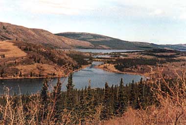
Photo: S. Johnston
A. LOCATION
Yukon Territory, Canada.61:5-61:8N, 137:0-137:0W; 914 m above sea level.
B. DESCRIPTION
Aishihik Lake is named in the Southern Tutchone Indian language meaning for "under the tail", referring to the shape of the bay at the north end of the lake adjacent to the abandoned Aishihik Village. The lake lies within the Ruby Range Ecoregion which is part of the Boreal Corderilla Ecozone of the Yukon Territory. At an elevation of 914 meters above sea level, the lake is bordered to the west by the Ruby Range and to the east by undulating terrain reaching some 1,500 m. Aishihik Lake drains southwestward to the Pacific Ocean via Canyon Lake and the Aishihik, Dezadeash and Alsek Rivers.The geology of this ecoregion typically includes granodiorite, quartz diorite and granite. The presence of glacio-fluvial and morainal materials in valleys and along mountain flanks provides evidence of glaciation which originated from the Coast and St. Elias Mountains.
Aishihik Lake lies in an area of discontinuous permafrost, the presence and exposure of which lead to significant siltation in the northern end of Aishihik Lake when the lake level was artificially raised after the construction of a dam at the lake outlet in the mid-1970's. The degree of permafrost laden soils sloughing into the lake apparently has decreased as the shoreline has begun to stabilize. Significant shore erosion took place during early stage of the reservoir's life, but data do not exist to state if such conditions have continued.
At elevations below treeline (1200 m a. s. l.), white spruce forests predominate with black spruce occurring in the poorer drained areas. Deciduous trees, though not as abundant, include aspen, balsam poplar and paper birch. Frequently, forests and stream banks are interspersed with sedge meadows. Shrub birch and willows are predominant in the subalpine regions.
Historically, Aishihik Lake was a major gathering place and settlement area for the Southern Tutchone people whose subsistence needs were in part fulfilled through fishing the resources of Aishihik Lake. The principal settlement, Aishihik Village, was located at the north end of the lake.
During the construction of the Alaska Highway (during WW II), an airport was maintained at Aishihik, near the village. Many of the Indian residents died as a result of disease outbreaks (influenza, measles, pneumonia).
Although the inhabitants of the Aishihik Lake area had moved by the mid 1960's to be closer to medical and educational support in Haines Junction, the area still provides an important food fishery to the members of the Champagne/Aishihik Band (located in Haines Junction). Resource use will likely increase in future years as the interest of Indian people in maintaining traditional lifestyles continues to rise. As well, improved access resulting from the construction of a flow control dam in the mid 1970's at the outlet of Aishihik Lake, continues to enhance the recreational fishing opportunities at Aishihik Lake.
The Aishihik River Power Development Project commenced in 1972 and involved the construction of flow control dams at the outlet of Aishihik and Canyon Lakes, a power canal from the outlet of Canyon Lake and an underground power generating station (30 megawatts). During the power project construction period, numerous studies were conducted on lake limnology and stream characteristics by the Federal Department of Environment-Fisheries and Marine Service to attempt to document pre-impact baseline information. Most of the limnological information in this summary originates from these studies (Q).
C. PHYSICAL DIMENSIONS (4, 5)
| Surface area [km2] | 146 |
| Volume [km3] | 4.38 |
| Maximum depth [m] | 120*1 |
| Mean depth [m] | 30 |
| Water level | Regulated |
| Normal range of annual water | |
| level fluctuation [m] | 1.8*2-0.8*3 |
| Length of shoreline [km] | 153 |
| Residence time [yr] | 14.6*4 |
| Catchment area [km2] | 2,765 |
*3 Actual 1987-dam regulated.
*4 Based on 1987 daily discharge rates.
D. PHYSIOGRAPHIC FEATURES
D1 GEOGRAPHICALSketch map: Fig. NAM-27-0l.
Bathymetric map: Fig. NAM-27-02.
Number of outflowing rivers and channels (name): 1 (East Aishihik R.).
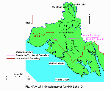
Sketch map (Q).
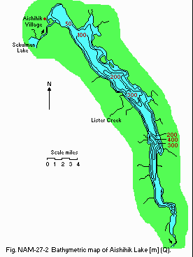
Bathymetric map [m](Q).
D2 CLIMATIC
Climatic data at AES Aishihik A Station, 1951-1980 (6)
Mean temp. [deg C]
| Jan | Feb | Mar | Apr | May | Jun | Jul | Aug | Sep | Oct | Nov | Dec | Ann. |
|---|---|---|---|---|---|---|---|---|---|---|---|---|
| -23.6 | -16.9 | -12.2 | -3.7 | 4.2 | 9.8 | 12.1 | 10.3 | 5.1 | -2.6 | -13.6 | -21.9 | -4.4 |
| Jan | Feb | Mar | Apr | May | Jun | Jul | Aug | Sep | Oct | Nov | Dec | Ann. |
|---|---|---|---|---|---|---|---|---|---|---|---|---|
| 2 | 9 | 10 | 8 | 22 | 41 | 49 | 41 | 25 | 16 | 12 | 12 | 247 |
Solar radiation (Whitehorse Airport)[MJ m-2 day-1](6a)
| Jan | Feb | Mar | Apr | May | Jun | Jul | Aug | Sep | Oct | Nov | Dec | Ann. |
|---|---|---|---|---|---|---|---|---|---|---|---|---|
| 1.3 | 4.0 | 9.2 | 15.7 | 19.6 | 21.0 | 18.8 | 15.0 | 9.0 | 4.4 | 1.6 | 0.7 | 10.0 |
Station 54*1, 1972
[m]
| Depth | 16 Jun | 21 Jun | 1 Jul | 12 Jul |
|---|---|---|---|---|
| S* | 4.0 | 5.0 | 9.0 | 14.8 |
| 2.0 | 4.0 | 5.0 | 5.0 | 14.0 |
| 4.0 | 4.0 | 5.5 | 5.0 | 11.0 |
| 6.0 | 4.0 | 5.5 | 5.0 | 8.0 |
| 10.0 | 4.0 | 4.7 | 5.0 | 6.3 |
| 15.0 | 4.0 | 4.8 | 5.0 | 5.2 |
| 20.0 | 4.0 | 5.1 | 5.0 | 4.9 |
| 30.0 | 4.0 | 4.8 | 5.0 | 4.2 |
Mixing type: Dimictic.
E. LAKE WATER QUALITY
E1 TRANSPARENCY [m]Station 51, August, 1972 (2) and 1975 (8)
[m]
| Depth | 1972 | 1975 |
|---|---|---|
| N.A. | 0.2 |
[m]
| Depth | 1972 | 1975 |
|---|---|---|
| 6.0 | 1.4 |
[m]
| Depth | 1972 | 1975 |
|---|---|---|
| 8.5 | 3.7 |
[m]
| Depth | 1972 | 1975 |
|---|---|---|
| 8.5 | 2.1 |
[m]
| Depth | 1972 | 1975 |
|---|---|---|
| +9.0 | 3.7 |
[m]
| Depth | 1972 | 1975 |
|---|---|---|
| +9.0 | 4.9 |
[m]
| Depth | 1972 | 1975 |
|---|---|---|
| N.A. | 7.3 |
Station 51, 21 June 1972
[m]
| Depth | DO | %*1 |
|---|---|---|
| S*2 | 10.8 | 100 |
| 2 | 10.7 | 99 |
| 4 | 10.4 | 105 |
| 6 | 11.9 | 94 |
Station 54, 21 June 1972
[m]
| Depth | DO | % |
|---|---|---|
| S | 11.1 | 87 |
| 2 | 11.2 | 88 |
| 4 | 10.5 | 80 |
| 6 | 11.3 | 88 |
| 10 | 11.3 | 86 |
| 15 | 11.3 | 87 |
| 20 | 11.2 | 87 |
| 30 | 11.1 | 86 |
[m]
| Depth | DO |
|---|---|
| S | 10.6 |
| 2 | 10.9 |
| 4 | 10.8 |
| 6 | 10.9 |
Nitrite [mg l-1](7)
Station 54, July 1972
| Surface | 15-18 m | 30-35 m |
|---|---|---|
| <0.005 | <0.005 | <0.005 |
[m]
| Depth | 1972 | 1975 |
|---|---|---|
| <.01 | .005 |
[m]
| Depth | 1972 | 1975 |
|---|---|---|
| <.01 | <.005 |
[m]
| Depth | 1972 | 1975 |
|---|---|---|
| <.01 | <.005 |
Station 54, July 1972
| Surface | 15-18 m | 30-35 m |
|---|---|---|
| N.D. | 0.23 | 0.04 |
[m]
| Depth | 1972 | 1975 |
|---|---|---|
| - | .04 |
[m]
| Depth | 1972 | 1975 |
|---|---|---|
| - | .03 |
[m]
| Depth 1972 | 1975 | |
|---|---|---|
| - | .02 |
PO4 [mg l-1]
Station 54, July 1972
| Surface | 15-18 m | 30-35 m |
|---|---|---|
| <0.01 | 0.01 | <0.01 |
[m]
| Depth | 1972 | 1975 |
|---|---|---|
| - | .02 |
[m]
| Depth | 1972 | 1975 |
|---|---|---|
| - | .005 |
[m]
| Depth | 1972 | 1975 |
|---|---|---|
| - | .005 |
Station 54, July 1972
| Surface | 15-18 m | 30-35 m |
|---|---|---|
| <0.01 | 0.015 | 0.02 |
[m]
| Depth | 1972 | 1975 |
|---|---|---|
| .01 | .02 |
[m]
| Depth | 1972 | 1975 |
|---|---|---|
| <.01 | <.01 |
[m]
| Depth | 1972 | 1975 |
|---|---|---|
| <.01 | <.01 |
F. BIOLOGICAL FEATURES
F2 FAUNAZooplankton (7)
Juvenile copepods (54%); Diaptomus probilofensis (27%); Cyclops sp. (16%); Daphnia pulex (2.4%); Senecella calanoides (0.5%); Heterescope septentrionalis (0.1%)(summarized relative abundance in surface and vertical plankton surveys from all lake stations in 1972).
Benthos (7)
Tendipedidae larvae, Oligochaeta, dipteran larvae, gastropods, polychaetes (summary of dredge surveys from all lake stations; the dredge results may not be truly representative of the benthos composition due to the prevalence of small boulders on the lake bottom in 1972 in the descending order of abundance).
Fish (7)
Coregonus clupeaformis, Salvelinus namaycush, Prosopium cyclindraceum, Thymallus arcticus, Esox lucius, Catastomus catastomus, Lota lota, Cottus cognatus.
F5 FISHERY PRODUCTS (10)
Estimated by Morphoedaphic index.
Annual fish catch (estimated): 20,414 kg.
G. SOCIO-ECONOMIC CONDITIONS
G1 LAND USE IN THE CATCHMENT AREA (2)1988
Types of important forest or scrub vegetation
White & black spruce, aspen, balsam poplar, paper birch, willow, shrub birch, soapberry, alder and ericaceous shrubs.
Types of the other important vegetation: Sedges, mosses and lichens.
Main kinds of crops and/or cropping systems: None.
Trends of change in land use in recent years Road to the campground at north end of the lake improved. Reservoir for Aishihik hydro development from mid-1970's.
G2 INDUSTRIES IN THE CATCHMENT AREA AND THE LAKE
1988
Fisheries
Indian food fishery, located primarily at north end of Canyon Lake
and at north end of Aishihik Lake, is composed of a relatively few number
of individuals (less than 50 estimated). Catches are not monitored but
are believed to be small (estimates: 200 kg lake trout, 600 kg whitefish,
50 kg sucker, 100 kg grayling). There is also recreational fishery on Aishihik
Lake. Catches are not monitored on a regular basis nor is effort. Yukon
Territory Parks and Recreation conducted a recreation use survey in 1988
but data are not yet available. There is also a late winter recreational
ice fishery involving mostly resident fishermen.
Power generation
There is a hydro-electric power plant near outlet of Canyon Lake.
G3 POPULATION IN THE CATCHMENT AREA
1988:(rural)
One person at Soldier Bay on continuous basis and 25 (max.) at Aishihik
Village June through September. Closest urban centre is the town of Haines
Junction (not in the catchment area).
H. LAKE UTILIZATION
H1 LAKE UTILIZATIONNavigation and transportation (to access other lakes in the headwaters for hunting, fishing and recreational pursuits), sightseeing and tourism (approximately 40 tourists/week during July and August (pers. comm. Yukon Gov't Parks & Rec.)), recreation (sport-fishing, hunting; estimated 20 hunters/week during August and September use lake for travel (pers. comm. Yukon Gov't Parks & Rec.)), fisheries (and trapping (2 traplines in the area)).
H2 THE LAKE AS WATER RESOURCES (12)
1988
| Use rate | |
|---|---|
| Domestic | 10 [galls day-1] |
| Irrigation | - |
| Industrial | - |
| Power plant | 128.478 [m3 sec-1] |
| and produces 369.9 GWh | |
| Others | - |
I. DETERIORATION OF LAKE ENVIRONMENTS AND HAZARDS
I1 ENHANCED SILTATIONExtent of damage
Minimal to moderate except at higher water level. Frequent siltation of the north end of Aishihik Lake caused by high water levels and erosion of exposed permafrost as well as by the increased activity at Aishihik Village by the Champagne/Aishihik Band who plans to increase the use of this area.
I2 TOXIC CONTAMINATION [mg l-1]
Station 54, July 1972 (7)
| Depth [m] | Surface | 15-18 | 30-35 |
|---|---|---|---|
| Zinc | <0.01 | 0.03 | 0.12* |
| Copper | N. D. | <0.01 | <0.01 |
| Iron | <0.03 | <0.03 | 0.83* |
| Lead | <0.02 | 0.26 | 0.46* |
1972 (7) and 1975 (Q)
| Station 51 | Station 54 | Station 58 | ||||
|---|---|---|---|---|---|---|
| 8/72 | 8/75 | 8/72 | 8/75 | 8/72 | 8/75 | |
| Zinc | <.01 | <.01 | <.01 | <.01 | <.01 | <.01 |
| Copper | - | <.02 | <.01 | <.02 | <.01 | <.02 |
| Iron | .11 | .55 | <.03 | .06 | <.03 | .03 |
| Lead | <.02 | <.01 | <.02 | <.01 | <.13 | <.01 |
J. WASTEWATER TREATMENTS
J1 GENERATION OF POLLUTANTS IN THE CATCHMENT AREA- a) No major human settle. ments or activities producing significant
pollution, except siltation at high water level.
K. IMPROVEMENT WORKS IN THE LAKE
Kl RESTORATIONNo major restoration recently.
L. DEVELOPMENT PLANS
Champagne/Aishihik Band has recently improved road access to Aishihik Village and has constructed/renovated a number of buildings around the former village site, plans to increase use of this area and use it as a summer retreat for fishing, hunting, berry picking, etc. The north end of Aishihik and Sekulmun Lakes has been selected by the Band for inclusion in their land claims negotiations with the Federal Government. These negotiations are currently in progress and should be completed soon.There was/is a plan to divert some streams from other adjacent watersheds into the Aishihik drainage to increase the hydroelectric generation potential. This plan is not currently being actively pursued. This area has had some mining exploration activity in the past. The degree to which this would occur in future largely depends on world mineral prices. There are no mines in operation in the drainage now.
M. LEGISLATIVE AND INSTITUTIONAL MEASURES FOR UPGRADING LAKE ENVIRONMENTS
M1 NATIONAL AND LOCAL LAWS CONCERNEDNames of the laws (the year of legislation)
- Canada Water Act
- Canada Fisheries Act
- Northern Inland Waters Act
- Canada Environmental Protection Act
- Gasoline Handling Act
- Yukon-Placer Mining Act Responsible authorities
- Department of the Environment
- Department of Fisheries & Oceans; Environment
- Department of Indian Affairs & Northern Development
- Department of the Environment
- Yukon Territorial Government
- Department of Indian Affairs & Northern Development Main items of control
- Water quality guidelines and phosphate control
- Fish harvesting, protection of fish habitats & pollution of fish habitats
- Water use licensing (hydro, mining, etc.)
- Persistent toxic chemicals during manufacturing, use & disposal
- Gasoline storage tanks & shipment facility criteria & maintenance
- Access to water for placer-mining purposes
The Federal Department of Fisheries and Oceans has agreed to transfer fisheries management responsibility to the Yukon Territorial Government. This is tentatively supposed to happen in 1989. The Federal and Territorial Governments have approved/ratified an agreement in principle with respect to Yukon Indian land claims. Individual Band negotiations are under way following the framework agreement which was ratified. The Champagne/Aishihik Band negotiation will include the Aishihik drainage with regards to land tenure, nature resources, land use, etc.
M3 RESEARCH INSTITUTES ENGAGED IN THE LAKE ENVIRONMENT STUDIES
No research being done currently on the lake.
N. SOURCES OF DATA
- Questionnaire filled by Drs. S. Johnston & M. Jarvis, Dept. of Fisheries & Oceans, Whitehorse, Yukon Territory.
- The Champagne-Aishihik Indian Band (1988) From Trail to Highway: Kwaday kwatan ts'an ek'an tan kwatsin: A Guide to the Places and the People along the Whitehorse, Yukon to Haines, Alaska Corridor. 49 pp. Morris Printing Co. Ltd., Victoria, B. C.
- Oswald, E. T. & Senyk, J. P. (1977) Ecoregions of Yukon Territory. 115 pp. Fisheries and Environment Canada.
- Environment Canada, Fisheries Service (1973) Fisheries Problems Associated with the Proposed Aishihik River Power Development. 45 pp. Interim Report.
- Robertson, R. A. & Eliasen, B. R. (1974) Environmental engineering studies associated with Aishihik River hydroelectric development. "The Aishihik Hydroelectric Development: Implications for Fisheries Resource Maintenance" (ed. Shouwenburg, W. J.), 60 pp. Environment Canada, Fisheries & Marine Service, Northern Operations Branch, Pacific Region, Technical Report PAC/T-74-19, Appendix B.
- Yukon Energy Corp. (1988) Annual Water License Report 1987. Submitted to the Yukon Territory Water Board, July 11, 1988.
- Environment Canada, Atmospheric Environment Service. Canadian Climate Normals 1951-1980. Temperature and Precipitation. The North-Yukon Territory and Northwest Territories.
- ) Environment Canada, Atmospheric Environment Service. Canadian Climate Normals 1951-1980.
- Kussat, R. (1973) Report on the 1972 Aishihik Lake, Yukon Territory limnological survey, Manuscript Report 1973-1. "The Aishihik Hydroelectric Development: Implications for Fisheries Resource Mfaintenance" (ed. Shouwenburg, W. J.), 80 pp. Environment Canada, Fisheries & Marine Service, Northern Operations Branch, Pacific Region, Technical Report PAC/T-74-19, Appendix E.
- Cleugh, T. & Graham, C. (1975) Memorandum Report on the 1975 Aishihik Lake Water Chemistry Survey. Environment Canada, Fisheries & Marine Service, file no. 5900-B5-A13.
- Walker, C. E. & Brown, R. F. (1974) Stream Studies in the Aishihik System with Reference to Hydroelectric Development. Environment Canada, Fisheries & Marine Service, Northern Operations Branch, Pacific Region, Report PAC/T.-74-9.
- Horler, A. (1982) On Estimating the Productivity of Select Yukon Lakes Using the Morphoedaphic Index; Yukon Lake Survey 1981. Draft Report, Dept. Fisheries & Oceans, Whitehorse, Yukon.
- Yukon Land Use Planning Program. Department of Indian Affairs and Northern Development (403-667-3100).
- Yukon Electric Co. Ltd. (1988) Annual Report; 1989-1990 Annual Forecast. Yukon Energy Corp.
