
KOOTENAY LAKE
A view on the lakeshore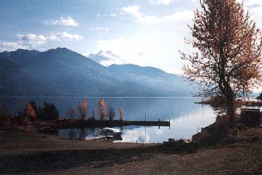
Photo: G. Bell
A. LOCATION
British Columbia, Canada.49:8N, 116:5W; 529.7 m above sea level.
B. DESCRIPTION
Kootenay Lake is a long narrow and deep fjord-like lake. The basin has steep sides, a relatively flat bottom, a U-shaped cross-section profile and a very narrow littoral zone. At each end of the lake the bottom gradually shallows up to the deltas of the Kootenay and Duncan Rivers. Relatively gentle slopes are associated with the deltas of the larger streams that flow into the lake from its flanks but these deltas are of limited areal extent.The geological origin of Kootenay Lake is said to be the result of river erosion which commenced in the late Cretaceous and continued through the Tertiary keeping pace with the growing mountain ranges until ice filled the valley in the Pleistocene. Valley glaciers originating in the Purcell and Selkirk Mountains fed the main ice mass from the sides. During this time the large valley glacier that occupied what is now the West Arm (outlet) of Kootenay Lake flowed into the Kootenay ice mass from the west. A large terminal moraine formed near what is now the big bend in the Kootenay River near Libby, Montana. As ice melted a lake formed behind the moraine and drained southward over it. As ice melted from the West Arm drainage became established over a lower divide near Nelson causing the West Arm to drain toward the west. The southerly drainage over the moraine dried up and the Kootenay River began to follow its present arcuate path (Fig. NAM-25-01).
The lake has long served as a transportation route. Native Indian populations first used the lake and associated river systems as part of their migration and trading routes. Mining activity began in the drainage basin with the discovery of gold in the 1820's near Bonners Ferry, Idaho. Although mineralization was known around the shores of Kootenay Lake as early as 1825, it was not until 1890 that wholesale staking and development began. For the most part the late development, as in the upper Kootenay Valley (Kimberley), was due to the late change in attitude of the miners from the search for 'easily won' placer deposits to the more laborious techniques of lode-mining. Mining activity in the Kootenay basin blossomed between 1905 and 1920, then collapsed during the depression years. Fruit growing was touted as a significant industry in the bench lands around the West and North Arms in the early 1900's; however a short growing season ended this dream. Fruit production has remained an important agricultural crop at the south end of the lake near Creston, B. C.
Today Kootenay Lake is a major recreation area for both local residents and tourists. A well known sports fishery, sailing and beautiful scenery draw many to the area.
Water quality in the lake was affected by the construction of a fertilizer plant in the early 1950's. Large loadings of phosphorus entered the Kootenay River drainage causing nuisance blue-green algae blooms in the 1950's, 1960's and early 1970's. Pollution abatement measures and subsequent closure of the plant, together with construction of the Libby Dam on the Kootenay River, have reduced phosphorus loadings to the lake to less than historic levels in 1988.
The overall impact of reductions to phosphorus loading to the lake and a subsequent decrease in algal productivity is not yet well understood. No discernible annual trends in zooplankton were evident in a 1984 study. A major decline in Kokanee stocks associated with the lake outlet may be in part related to the reduction of phosphorus to the lake (1).
C. PHYSICAL DIMENSIONS (1, 2)
| Surface area [km2] | 389 |
| Volume [km3] | 36.7 |
| Maximum depth [m] | 154 |
| Mean depth [m] | 94 |
| Water level | Regulated |
| Normal range of annual water | |
| level fluctuation [m] | 4 |
| Length of shoreline [km] | 198.4* |
| Residence time [yr] | 1.8 |
| Catchment area [km2] | 45,584 |
D. PHYSIOGRAPHIC FEATURES
D1 GEOGRAPHICALSketch map: Fig. NAM-25-0l (1).
Bathymetric map: Fig. NAM-25-02 (1).
Names of main islands: None.
Number of outflowing rivers and channels (name): 1 (Kootenay R.).
D2 CLIMATIC
Climatic data at Harrop, 1983-1988*
Mean temp. [deg C]
| Jan | Feb | Mar | Apr | May | Jun | Jul | Aug | Sep | Oct | Nov | Dec | Ann. |
|---|---|---|---|---|---|---|---|---|---|---|---|---|
| -2.2 | -0.5 | 3.3 | 7.7 | 11.7 | 15.6 | 17.4 | 17.9 | 11.6v7.2 | -0.3 | -2.7 | 7.2 |
| Jan | Feb | Mar | Apr | May | Jun | Jul | Aug | Sep | Oct | Nov | Dec | Ann. |
|---|---|---|---|---|---|---|---|---|---|---|---|---|
| 49 | 38 | 53 | 39 | 49 | 41 | 32 | 28 | 62 | 50 | 91 | 50 | 581 |
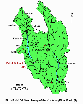
Sketch map of the Kootenay River Basin (1).
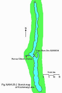
Bathymetric map with location of monitoring sites.
Number of hours of bright sunshine (Castlegar): 1,875.9 hr yr-1* (3).
* 15-19 years mean.
Solar radiation (Summerland)[m-2 day-1](3)
| Jan | Feb | Mar | Apr | May | Jun | Jul | Aug | Sep | Oct | Nov | Dec | Ann. |
|---|---|---|---|---|---|---|---|---|---|---|---|---|
| 3.44 | 6.48 | 11.54 | 16.66 | 20.82 | 22.64 | 23.68 | 19.55 | 14.47 | 8.45 | 3.82 | 2.50 | 12.8 |
Cape Horn, 1986
[m]
| Depth | Jan | Feb | Mar | Apr | May | Jun | Jul | Aug | Sep | Oct | Nov | Dec |
|---|---|---|---|---|---|---|---|---|---|---|---|---|
| 1 | - | - | 4.6 | 4.5 | 12.5 | 16.2 | 14.5 | 18.0 | 15.3 | 11.7 | 9.2 | - |
| 5 | - | - | 4.3 | 4.5 | 11.5 | 14.1 | 14.0 | 17.5 | 15.4 | 11.8 | 9.2 | - |
| 10 | - | - | 4.2 | 4.5 | 9.8 | 12.5 | 13.6 | 17.0 | 15.3 | 11.9 | 9.2 | - |
| 20 | - | - | 3.8 | 4.4 | 8.5 | 10.6 | 12.7 | 13.9 | 13.8 | 11.7 | 9.1 | - |
| 25 | - | - | - | 4.3 | 7.7 | 9.9 | 12.3 | 11.5 | 10.5 | 11.4 | 9.1 | - |
| 30 | - | - | 3.7 | 4.2 | 7.0 | 8.5 | 9.6 | 9.4 | 8.3 | 11.2 | 9.1 | - |
| 60 | - | - | 3.5 | 3.9 | 5.4 | 5.4 | 5.2 | 5.5 | 4.9 | 4.7 | 4.9 | - |
| 130 | - | - | 3.3 | 3.3 | 3.9 | 3.8 | 3.7 | 3.8 | 3.8 | 3.8 | 3.7 | - |
Mixing type: Dimictic.
Notes on water mixing and thermocline formation
Large-scale circulation is primarily determined by three distinct but interdependent physical wave dynamics and river through-flow (1).
E. LAKE WATER QUALITY
E1 TRANSPARENCY [m](5)Cape Horn, 1984
[m]
| Depth | Jan | Feb | Mar | Apr | May | Jun | Jul | Aug | Sep | Oct | Nov | Dec |
|---|---|---|---|---|---|---|---|---|---|---|---|---|
| - | - | 14 | 12.5 | 5.5 | - | 4.1 | 4.5 | 7.2 | 6.0 | 10.5 | - |
Cape Horn, 1986
[m]
| Depth | Jan | Feb | Mar | Apr | May | Jun | Jul | Aug | Sep | Oct | Nov | Dec |
|---|---|---|---|---|---|---|---|---|---|---|---|---|
| 1 | - | - | 10.3 | 7.8 | 8.3 | 8.3 | 8.0 | 8.4 | 7.3 | 7.5 | 8.2 | - |
| 20 | - | - | 8.2 | 7.8 | 8.1 | 8.0 | 8.0 | 8.0 | 7.8 | 7.7 | 8.1 | - |
| 30 | - | - | 8.2 | 7.9 | 8.0 | 7.9 | 7.9 | 7.9 | 7.7 | 7.7 | 8.1 | - |
| 60 | - | - | 8.1 | 7.9 | 8.0 | 7.9 | 7.9 | 7.8 | 7.7 | 7.7 | 7.9 | - |
| 130 | - | - | 8.0 | 7.8 | 7.9 | 7.8 | 7.8 | 7.7 | 7.7 | 7.6 | 7.8 | - |
Cape Horn, 1984
[m]
| Depth | Jan | Feb | Mar | Apr | May | Jun | Jul | Aug | Sep | Oct | Nov | Dec |
|---|---|---|---|---|---|---|---|---|---|---|---|---|
| 1 | - | - | <1.0 | <1.0 | - | <1.0 | - | <1.0 | <1.0 | <1.0 | - | |
| 130 | - | - | <1.0 | <1.0 | - | <1.0 | <1.0 | <1.0 | <1.0 | <1.0 | - |
Cape Horn, 1986
[m]
| Depth | Jan | Feb | Mar | Apr | May | Jun | Jul | Aug | Sep | Oct | Nov | Dec |
|---|---|---|---|---|---|---|---|---|---|---|---|---|
| 1 | - | - | 11.9 | 12.5 | 11.1 | 10.3 | 9.7 | 9.6 | 11.1 | 11.1 | 10.4 | - |
| 20 | - | - | 11.6 | 12.1 | 11.0 | 10.2 | 9.8 | 9.1 | 9.9 | 9.8 | 10.2 | - |
| 30 | - | - | 11.4 | 12.0 | 13.7 | 10.4 | 10.0 | 9.3 | 10.2 | 9.7 | 10.2 | - |
| 60 | - | - | 11.3 | 11.7 | 10.9 | 10.6 | 10.5 | 10.2 | 10.9 | 10.4 | 10.5 | - |
| 130 | - | - | 10.5 | 13.2 | 10.6.10.3 | 10.4 | 9.8 | 9.9 | 9.9 | 10.0 | - |
Cape Horn, 1984
[m]
| Depth | Jan | Feb | Mar | Apr | May | Jun | Jul | Aug | Sep | Oct | Nov | Dec |
|---|---|---|---|---|---|---|---|---|---|---|---|---|
| 1 | - | - | 0.9 | 0.8 | 1.8 | - | 2.4 | 2.7 | 1.2 | 2.5 | 1.4 | - |
| 5 | - | - | 0.9 | 2.0 | 3.7 | - | 3.1 | 3.0 | 1.6 | 2.3 | 1.5 | - |
| 10 | - | - | 0.9 | 1.9 | 2.8 | - | 3.2 | 3.3 | 1.4 | 2.2 | 1.5 | - |
| 15 | - | - | 0.9 | 1.6 | 2.4 | - | 2.6 | 1.5 | 1.5 | 2.5 | 1.4 | - |
| 20 | - | - | 0.8 | 1.4 | 1.4 | - | 2.3 | 1.2 | 0.9 | 2.6 | 1.4 | - |
Cape Horn,1984
NO2 + NO3-N [mg l-1]
[m]
| Depth | Jan | Feb | Mar | Apr | May | Jun | Jul | Aug | Sep | Oct | Nov | Dec |
|---|---|---|---|---|---|---|---|---|---|---|---|---|
| 1 | - | - | .12 | .11 | .04 | - | .03 | - | <.02 | .02 | .07 | - |
| 65 | - | - | .13 | .13 | .13 | - | .13 | .14 | .14 | .14 | .15 | - |
| 130 | - | - | .13 | .14 | .14 | - | .14 | .14 | .15 | .17 | .16 | - |
[m]
| Depth | Jan | Feb | Mar | Apr | May | Jun | Jul | Aug | Sep | Oct | Nov | Dec |
|---|---|---|---|---|---|---|---|---|---|---|---|---|
| 1 | - | - | <.005 | <.005 | .005 | - | .005 | - | .005 | <.005 | <.005 | - |
| 65 | - | - | <.005 | <.005 | <.005 | - | <.005 | <.005 | <.005 | <.005 | <.005 | - |
| 130 | - | - | <.005 | <.005 | <.005 | - | <.005 | <.005 | <.005 | <.005 | <.005 | - |
Total-P [mg l-1]
Cape Horn, 1984
[m]
| Depth | Jan | Feb | Mar | Apr | May | Jun | Jul | Aug | Sep | Oct | Nov | Dec |
|---|---|---|---|---|---|---|---|---|---|---|---|---|
| 1 | - | - | .004 | .008 | .009 | - | .010 | - | .008 | .007 | - | - |
| 65 | - | - | .005 | .008 | .005 | - | .007 | .006 | .009 | .005 | - | - |
| 130 | - | - | .006 | .011 | .009 | - | .010 | .005 | .008 | .008 | - | - |
Phosphorus input via Kootenay River has been drastically reduced since 1968. The installation of settling ponds by Cominco's fertilizer operation at Kimberley in 1969 and start up of an effluent recycling program in 1975 have been the major causes contributing to the decline. The annual means of total and ortho phosphorus concentrations in the Kootenay River were cut in half from 1968 to 1969 and have continued to decline very significantly (Fig. NAM- 25-04). The rate of decline levelled off in 1977. Presently the annual phosphorus loading is probably at or near historic levels prior to fertilizer plant input (1).
Concurrent with the declining phosphorus input, annual mean total and ortho phosphorus concentrations at all lake sites and depths have declined very significantly. Unlike the river, the decline in lake phosphorus concentrations has continued, although much slower, since 1977. A strong north-south gradient in spring ortho phosphorus concentrations was present up to 1978 but has now all but disappeared. Spring means of total and ortho phosphorus were similar for all three sites in phosphorus concentrations to changes in river input is likely due to the short residence time of Kootenay Lake (approximately 1.8 years)(1, 5).
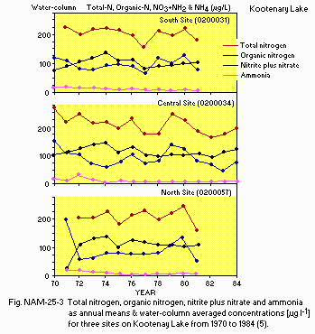
Total nitrogen, organic nitrogen, nitrite plus nitrate and ammonia as annual means & water-column averaged concentrations [micro g l-1] for three sites on Kootenay Lake from 1970 to 1984 (5).
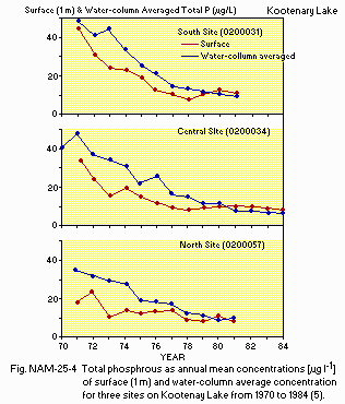
Total phosphorus as annual mean concentrations [micro g l-1] of surface (1 m) and water-column averaged concentration for three sites on Kootenay Lake from 1970 to 1984 (5).
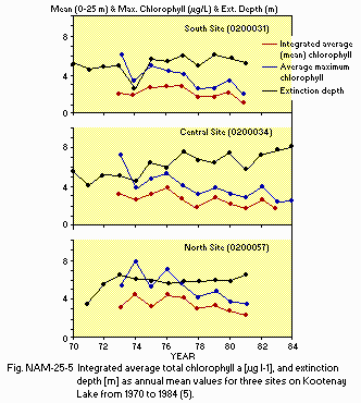
Integrated average total chlorophyll a [micro g l-1], and extinction depth (m) as annual mean values for three sites on Kootenay Lake from 1970 to 1984 (5).
F. BIOLOGICAL FEATURES
1981F1 FLORA
Emerged macrophytes
Typha latifolia, Alisma plantago-aquatica, Equisetum palustre, E. fluviatile, Scheuchzeria palustris, Sium sauve, Scirpus lacustris, Myosotis laxa, Rorippa nasturtium-aquaticum, Veronica americana, Sagittaria sp., Eleocharis acicularis, E. palustris, Sparganium eurycarpum, Veronica americana, Sagittaria sp., Eleocharis acicularis, E. palustris, Sparganium eurycarpum, S. angustifolium, Mimulus guttatus, Polygonum sp.
Floating macrophytes
Lemna minor, Ricciocarpus natans, Spirodella polyrhiza, Polygonum amphibium.
Submerged macrophytes (6)
Potamogeton crispus, P. perfoliatus, P. illinoensis, P. friesii, P. robbinsii, P. zosteriformis, P. natans, P. gramineus, P. pusillus, P. pectinatus, P. praelongus, P. amplifolius, P. alpinus, Myriophyllum exalbescens, M. ussuriense, Ranunculus flabellaris, R. flammula, R. huperboreus, R. aquatilis, Callitriche anceps, C. heterophylla, C. hermaphroditica, Elodea canadensis, Utricularia vulgaris, Vallisneria spiralis, Najas flexilis, Ceratophyllum demersum, Zannichellia palustris, Chara sp., Isoetes sp.
Phytoplankton (1987, composite samples of 1, 5, 10, 15 and 20 m at Cape Horn) Cryptomonas sp., Chroomonas acuta, Synedra acus, Fragilaria crotonensis, Rhizosolenia eriensis, Cyclotella glomerata, C. ocellata, C. kutzingiana, Tabellaria fenestrata, Navicula spp., Mallomonas quadrigula, Elakatothrix, Oocystis, Ankistrodesmus, Gloeocystis, Pseudanabaena sp., Aphanothece sp., Dinobryon bavaricum, D. divergens, Peridinium sp., Asterionella formosa (4).
F2 FAUNA
Zooplankton (4)
Copepods (Diaptomus ashlandi, D. kenai, Cyclops bicuspidatus), Epishura
nevadensis, Mysis relicta (introduced into the lake in late 1940's), cladocerans
(usually evident in summer and fall; Daphnia, Diaphanosoma, Ceriodaphnia),
Rotifers (Keratella cochlearis, Polyarthra, Kellicottia longispina, Asplanchnidae).
Fish (7)
Salmo gairdneri*, Salvelinus malma*, Onchorhynchus nerka*, Lota lota*,
Prosopium williamsoni*, Acipenser transmontanus, Salvelinus fontinalis,
Micropterus salmoides, Perca flavescens.
* Important for recreational fishery.
Supplementary notes (7)
Distinct stocks of at least salmo and Onchorhynchus for each of the
three (North, South & West) arms of the lake. This may also be true
for Salvelinus malma, Lota and Acipenser. The lake is renowned for its
Gerrard stock of Salmo which is unique due to their large size (up to 18
kg), late age at maturation and highly predacious nature.
F3 PRIMARY PRODUCTION RATE [g C m-2 yr-1](8)
Mean of North and South Arms, 1977: 175.
F4 BIOMASS
Phytoplankton* [mm3 m-3]
Cape Horn site, 1984
Cyanophyta: 61.
Total phytoplankton: 406.
* Annual arithmetic mean of water-column integrated (0-25 m) biovolume.
Zooplankton* [mg (dry wt.) m-2]
Cape Horn site, 1984
Cladocerans: 119.
Copepods: 1865.
Mysids: 4248.
* Annual arithmetic mean of total biomass .
F6 PAST TRENDS (5)
Significant decreases in annual means of integrated chlorophyll a (Fig.
NAM- 25-05) were observed only for site 0200034 (Cape Horn). However, annual
means of maximum chlorophyll a concentrations for each sample date showed
significant decreases for all sites. Spring means of integrated chlorophyll
a and maximum chlorophyll a concentrations were generally higher than annual
means and showed larger decreases since 1975.
F7 NOTE ON THE REMARKABLE CHANGES OF BIOTA IN THE LAKE IN RECENT
YEARS
None evident in recent years. There was a major drop in Onchorhynchus
numbers in the West Arm of the lake in the late 1970's. The West Arm Onchorhynchus
fishery was closed in 1980 and except for a brief opening in 1983 remainds
closed. The reason for lack of survival is not known but several possible
explanations have been put forth including reduced carry over of Mysis
relicta into the West Arm due to water level controls, disruption of rearing
habitat due to drawdown, reduced productivity of benthos due to reduction
of nutrient load to lake and overfishing in the 1960's and 1970's.
G. SOCIO-ECONOMIC CONDITIONS
G1 LAND USE IN THE CATCHMENT AREA (9)1982-86
| Area [km2] | [%] | |
|---|---|---|
| Natural landscape | ||
| Others | ca. 45,000*1 | 99 |
| Agricultural land | ca. 300 | less than 1 |
| Residential area*2 | very small | |
| Others | very small | |
| Total | 45,584 |
*2 Combined agricultural use.
Types of important forest or scrub vegetation
Fir, spruce, lodgepole pine, cedar, hemlock, balsam fir.
Main kinds of crops and/or cropping systems
Hay and grain; fruit trees in Creston area only.
Levels of fertilizer application on crop fields: Light.
Trends of change in land use in recent years
Increased logging in watersheds; surface mining for coal began in mid-70's, no further expansion at this time.
G2 INDUSTRIES IN THE CATCHMENT AREA AND THE LAKE (10)*1
1981
| Gross product | No. of | No. of | Main product | |
|---|---|---|---|---|
| per year*2 | persons | establish- | or major | |
| (US $1.00) | engaged | ments | industries | |
| Primary industry | ||||
| Crop | 14,600,000*3 | 685*3 | N.A. | Hay, grain, |
| production | beef cattle, | |||
| diary, fruit | ||||
| (Creston) | ||||
| Fisheries*4 | 1,600,000 | 70,000 angler | ||
| (recreational) | [days/yr](11) | |||
| Others | ||||
| forestry | 1,000*3 | N.A. | Saw & pulp logs | |
| mining | 557,700,000 | 4,465*3 | 5 coal | Metallurgical |
| mines | & thermal coal | |||
| & lead/zinc | ||||
| concentrate | ||||
| Secondary industry | ||||
| Manufacturing | 407,786,000*3 | 2,800*3 | 1 pulp | Lumber, pulp |
| mill | & misc. | |||
| Tertiary industry | ||||
| Tourism | Unknown value |
*2 Current conversion rate to US%.
*3 Canada only.
*4 Fisheries on the lake concerned.
- Number of domestic animals in the catchment area
Cattle 31,843 (Creston area 8,843, East Kootenay 15,000, assume USA 8,000); swine, sheep and poultry are negligible.
1982
| Population | Major cities | ||
|---|---|---|---|
| Population | density [km-2] | (population) | |
| Total | 38,000* | <1 | Cranbrook (17,000) |
H. LAKE UTILIZATION
H1 LAKE UTILIZATIONSource of water and recreation (swimming, sport-fishing, yachting).
H2 THE LAKE AS WATER RESOURCES
| Use rate [m3 day-1] | |
|---|---|
| Domestic | 383 |
| Irrigation | 340,372 [m3 per season](275 acre feet) |
| Industrial | 668.5 |
| Others | |
| Conservation* | 30,837,500 [m3 per season](25,000 acre feet) |
I. DETERIORATION OF LAKE ENVIRONMENTS AND HAZARDS
I1 ENHANCED SILTATIONExtent of damage: Not serious.
I2 TOXIC CONTAMINATION
Present status: Detected but not serious.
Main contamination, their concentrations and sources (1)
1979
| Name of | Range of concentrations | Main Sources |
|---|---|---|
| contaminants | [ppm] in bottom mud | |
| T-Cu | 14-142 | Waste dumps; historic disposal of |
| T-Pb | 10-3,050 | waste rock & tailings; primarily |
| T-Zn | 45-3,440 | detrital sulphide minerals* |
I3 EUTROPHICATION
Nuisance caused by eutrophication
Unusual algal bloom (Anabaena): During 1960's and early 1970's, not evident now.
Nitrogen and phosphorus loadings to the lake
1977
| Sources | Natural | Total |
|---|---|---|
| Nitrate | 95%* | ca. 1,180,000 kg yr-1 |
| PO4-P | 70-90% | 51,000 kg yr-1 |
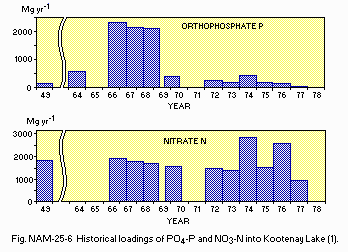
(1) Historical loadings of PO4-P and NO3-N into Kootenay Lake.
Supplementary notes
Orthophosphate-P (OP) loads increased from an estimated 140 Mg yr-1
in 1949 to 2,350 Mg yr-1 in 1966 and then decreased to 51 Mg yr-1 by 1977.
The peak value in 1966 represents an areal loading rate of 6 g m-2 yr-1,
a 17-fold increase over the 1949 loading. The 1977 rate was 0.13 g m-2
yr-1. The cause of the increase in OP loadings from 1949 to 1966 was the
discharge of phosphate-rich effluent from the Cominco fertilizer plant
in Kimberley. This plant began production in 1953, doubled production in
1962 and tripled production in 1965. In early 1969 pollution control measures
were improved at the plant and discharges of P were reduced dramatically.
The improvements were not working at their optimum until 1975 (Water Resources
Service, 1976a). The nitrate-N (NN) loads were fairly constant except during
1974, 1976 and 1977. The high loads in 1974 and 1976 resulted from increased
water flows without compensatory decreases in NN concentration. Construction
of the Libby Dam on the Kootenai [spelling in USA] River in Montana also
acted as a nutrient sink further reducing nutrient reaching Kootenay Lake.
The fertilizer plant in Kimberley was closed down in 1987. Loadings have
not been accurately calculated since 1977, although winter overturn values
suggest that 1984 values are approximately the same.
I4 ACIDIFICATION
Extent of damage: None.
Past trends in hydrogen ion concentration in lake water
No change evident in hydrogen ion concentration in lake water.
J. WASTEWATER TREATMENTS
J1 GENERATION OF POLLUTANTS IN THE CATCHMENT AREA- d) Measurable pollution with limited wastewater treatment.
No scientific quantification has been done; the following is an estimate only. Most pollutants are discharged into the Kootenay River and its tributaries. They are no longer measurable when the Kootenay River reaches the lake.
| [%] | |
|---|---|
| Non-point sources | 20 |
| (agricultural, natural and | |
| dispersed settlements) | |
| Point sources | |
| Municipal | 20 |
| Industrial | 60 |
| Total | 100% |
Percentage of municipal population in the catchment area provided with
adequate sanitary facilities (on-site treatment systems) or public sewerage: 90% (USA unknown).
Percentage of rural population with adequate sanitary facilities (on-site treatment systems): 85%.
Municipal wastewater treatment systems (numbers for Canada only)
No. of tertiary treatment systems: 2 (spray irrigation & ground disposal).
No. of secondary treatment systems: 4 (probably 2 more plants in USA).
Industrial wastewater treatment systems
No. of industrial wastewater treatment systems: 7.
Surface mines: settling ponds/flocculation and control of nitrogen based explosives.
Pulp mill: discharge to ground during low river flow, biological treatment ponds when discharged directly to river.
Cominco Sullivan Mine & Concentrator: lime treatment of effluent to reduce metals.
K. IMPROVEMENT WORKS IN THE LAKE
N.A.
L. DEVELOPMENT PLANS
No formal development plans.M. LEGISLATIVE AND INSTITUTIONAL MEASURES FOR UPGRADING LAKE ENVIRONMENTS
M1 NATIONAL AND LOCAL LAWS CONCERNEDNames of the laws (the year of legislation)
- Waste Management Act (1982)
- Waste Management Act (1979)
- Environment Management Act
- Federal Fisheries Act Responsible authorities
- Government of British Columbia, Ministry of Environment
- Government of British Columbia, Ministry of Environment
- Government of British Columbia, Ministry of Environment
- Government of British Columbia in cooperation with Government of Canada Main items of control
- Discharge of waste to land, air, water
- Licencing of consumptive and nonconsumptive water use
- Prevention of any activities which would have detrimental environmental impact
- Management and protection of fisheries Supplementary notes Many other pieces of legislation affect the lake directly or indirectly i.e. Forest Act, Mining Act. Also federal legislation such as Environmental Protection Act.
M3 RESEARCH INSTITUTES ENGAGED IN THE LAKE ENVIRONMENT STUDIES
N.A.
N. SOURCES OF DATA
- Questionnaire filled by Dr. R. Crozier, British Columbia Ministry of the Environment, Kootenay Region, Nelson, British Columbia.
- Daley, R. J., Carmack, E. C., Gray, C. B. J., Pharo, C. H., Jasper, S. & Wiegand, R. C. The effects of upstream impoundments on the limnology of Kootenay Lake, B. C.
- British Columbia Ministry of Environment. Water Management, Kootenay Region, Nelson, B. C.
- Environment Canada, Atmospheric Environment Service. Canadian Climate Normals. British Columbia, 1951-1980.
- British Columbia Ministry of Environment. Waste Management, Kootenay Region, Nelson, B. C.
- Crozier, Richard J. & Duncan, W. F. A., (1984) Kootenay Lake, Compilation and Synopsis of Physical, Chemical and Biological Data from 1968 to 1984. British Columbia Ministry of Environment.
- Warrington, P. D. Database for Aquatic Plants, Morphometry and Water and Sediment Chemistry for the Lakes in British Columbia. Resource Quality Section, Water Management Branch, British Columbia Ministry of Environment.
- ) Newroth, P. & Victoria, B. C. (1988) Personal communication.
- Andrusak, H. & Brown, C. Kootenay Lake Fisheries Management Plan 1987- 1989. British Columbia Ministry of Environment.
- Gray, C. Data. Canada Centre for Inland Waters, National Water Research Institute, Lakes Research Branch, Burlington, Ontario.
- National Topographic System. 1:250,000. Surveys & Mapping Branch, Department of Energy Mines & Resources. 1986 Sheet 82F, Edition 3, and 1981 Sheet 82K.
- British Columbia Regional Index (1986) British Colombia Ministry of Economic Development.
- Hammond, J. & Lindsay, B., Ministry of Environment, Recreational Fisheries. Personal communication.
- Census of Canada (1981) East Kootenay, Cranbrook, Kimberley Area and Central Kootenay Census Divisions.
