
PYRAMID LAKE
A view on the lakeshore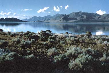
Photo: K. Hamilton
A. LOCATION
Nevada, USA.40:0N, 119:5W; 1,160 m above sea level.
B. DESCRIPTION
Pyramid Lake occupies a large, north-south oriented endorheic graben wholly within the Pyramid Lake Paiute Indian Reservation at the western margin of the Great Basin Desert. It is the largest remnant of pluvial Lake Lahontan, which at maximum Pleistocene development was about 22,300 km2. Presently, Pyramid Lake is the deepest terminal saline lake in the western hemisphere. Modern climate is typical of a mid-latitude steppe with low annual precipitation, most occurring during winter. Pyramid Lake receives about 85% of its annual water input from Truckee River, whose origin is Lake Tahoe in the Sierra Nevada mountains to the southwest. The lake is slightly saline and moderately alkaline, about 5 g l-1 salinity and 23 meq l-1 alkalinity. Order of cation abundance is: Na+ >K+ ¡¦Mg2+ >Ca2+, and among anions: Cl- >HCO3- >CO32- >SO42- . Dissolved orthophosphate concentrations are moderately high (¡¦70 mg P m- 3), while dissolved inorganic nitrogen concentrations are low (¡¦100 mg N m- 3), yielding low N: P ratios, indicative of potential nitrogen limitation.Lakewide precipitations of calcium carbonate ("whitings") occur irregularly (29), and massive calcium carbonate "tufa" deposits surround the lake. One of these tufa formations provides the lake's name (3). Anaho Island is the only major island, and hosts large nesting colonies of colonial birds, most notably, white pelicans (Pelecanus erythrorhynchos). Primary productivity is low for a saline lake, although moderate (about 500 mg m-2 day-1) compared with freshwater lakes (10). Large summer-autumn blooms of the nitrogen fixing cyanobacterium, Nodularia spumigena, occur regularly and contribute large amounts of nitrogen to the lake's annual nitrogen budget (1, 2).
Pyramid Lake was first recorded by Anglo Americans in 1844, who found the Native Americans consuming two endemic fishes, cui-ui (Chasmistes cujus) and Lahontan cutthroat trout (Salmo clarki henshawi). The Pyramid Lake Paiute Indian Reservation was established in 1859, following a brief period of armed conflict (3). Disputes over land, water and fisheries rights continued between Paiutes and Anglos and persist today as water rights and water quality litigation between the Pyramid Lake Paiute Tribe and upstream water users (4). Derby Dam was constructed in 1905 on the Truckee River,56 km upstream from Pyramid Lake. About 50% of the annual discharge to the lake was subsequently diverted out of the catchment basin for agriculture. Pyramid Lake's elevation declined 26 m between 1905 and 1967 and its salinity increased from about 3.7 g l-1 to its present level. Pyramid Lake supported a nationally renown sport fishery for Lahontan cutthroat trout prior to the 1940's and retains the world's sport-fishing size record for this species. However, as the lake level declined a large delta formed at the terminus of Truckee River, preventing spawning migrations of cui-ui and cutthroat trout. This delta and Derby Dam impeded upstream migration resulting in demise of the Lahontan cutthroat trout in 1938 (5). Lahontan cutthroat trout were reintroduced in the 1950's and a trophy sport fishery reestablished, although all recruitment is presently by artificial propagation. As a result of declines in both species, cui-ui were federally listed as endangered and Lahontan cutthroat trout as threatened. Major recovery efforts for both species are currently underway. Additional environmental concerns include maintaining lake water quality as populations upstream in the Truckee River watershed (primarily Reno and Sparks, Nevada), rapidly expand (Q).
C. PHYSICAL DIMENSIONS (Q)
| Surface area [km2] | 453 |
| Volume [km3] | 27 |
| Maximum depth [m] | 105 |
| Mean depth [m] | 60 |
| Length of shoreline [km] | 160 |
| Residence time [yr] | 50 |
| Catchment area [km2] | 4,730 |
D. PHYSIOGRAPHIC FEATURES
D1 GEOGRAPHICALBathymetric map: Fig. NAM-23-02.
Names of main islands: Anaho (3.03 km2).
Number of outflowing rivers and channels (name): None.
D2 CLIMATIC
Climatic data at Sutcliffe, Nevada, 1980-1988*
Mean temp. [deg C]
| Jan | Feb | Mar | Apr | May | Jun | Jul | Aug | Sep | Oct | Nov | Dec | Ann. |
|---|---|---|---|---|---|---|---|---|---|---|---|---|
| 2.1 | 4.4 | 6.5 | 10.5 | 14.9 | 20.0 | 23.7 | 24.2 | 18.8 | 13.0 | 7.3 | 3.9 | 12.4 |
| Jan | Feb | Mar | Apr | May | Jun | Jul | Aug | Sep | Oct | Nov | Dec | Ann. |
|---|---|---|---|---|---|---|---|---|---|---|---|---|
| 25 | 21 | 21 | 17 | 11 | 14 | 5 | 5 | 14 | 16 | 38 | 22 | 209 |
Number of hours of bright sunshine: 3,764 hr yr-1.
Solar radiation: 385 MJ m-2 day-1.
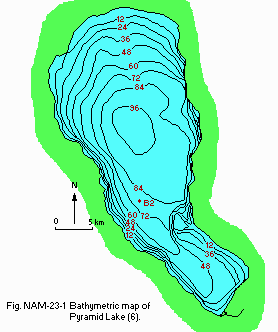
Bathymetric map (6).
Water temperature: cf. Fig. NAM-23-02 and 03.
Freezing period: None.
Mixing type: Monomictic.
Notes on water mixing and thermocline formation
Irregularly meromictic following abnormally high fluvial input.
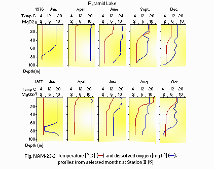
Temperature [deg C] and dissolved oxygen [mg l-1]; profiles from selected months at Station II (6).
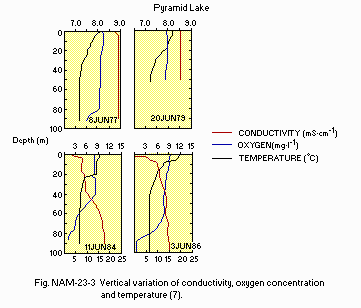
Vertical variation of conductivity, oxygen concentration and temperature (7).
E. LAKE WATER QUALITY
E1 TRANSPARENCY: Fig. NAM-23-04.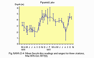
Mean Secchi disc readings and ranges for three stations, March 1976-October 1977 (8).
E2 pH (Q)
Station II, 1976
[m]
| Depth | Jan | Feb | Mar | Apr | May | Jun | Jul | Aug | Sep | Oct | Nov | Dec |
|---|---|---|---|---|---|---|---|---|---|---|---|---|
| 1 | 9.2 | 9.2 | 9.2 | 9.1 | 9.2 | 9.2 | 9.1 | 9.2 | 9.2 | 9.3 | 9.3 | 9.2 |
| 40 | 9.3 | 9.2 | 9.2 | 9.1 | 9.2 | 9.2 | 9.1 | 9.1 | 9.2 | 9.3 | 9.2 | 9.2 |
| 80 | 9.2 | 9.2 | 9.2 | 9.2 | 9.2 | 9.2 | 9.1 | 9.1 | 9.2 | 9.2 | 9.2 | 9.2 |
Station II: see Fig. NAM-23-02 and 03.
E6 CHLOROPHYLL CONCENTRATION: Fig. NAM-23-05, 06 and 07.
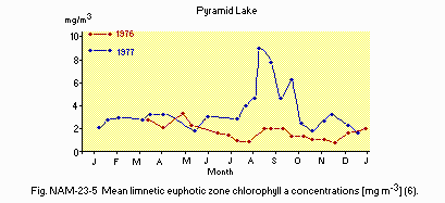
Mean limnetic euphotic zone chlorophyll a concentrations [micro g l-1](6).
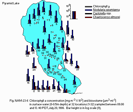
Chlorophyll a concentration [micro g l-1 x1.0E+3] and biovolume [micro m3 ml-1] of Nodularia spumigena. Cyclotella spp. and Chaetoceros elmorei in surface water (0 - 0.5 m depth) at 32 locations (1-32) sampled between 09.00 and 13.40 PDT, 20 July 1986 (9).
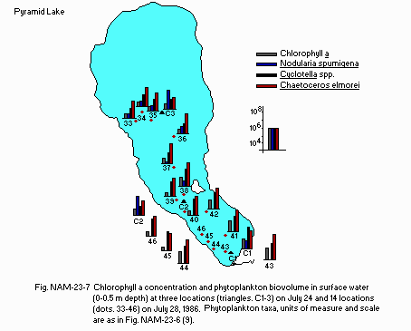
Chlorophyll a concentration and phytoplankton biovolume in surface water (0- 0.5 m depth) at three locations on July 24 and 14 locations on July 28, 1986. Phytoplankton taxa, units of measure and scale are as in Fig. NAM-23-06 (9).
E7 NITROGEN CONCENTRATION
NO3-N: Fig. NAM-23-08.
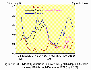
Monthly variations in nitrate (NO3-N) by depth in the lake January 1976 through December 1977 (6).
Total-N [mg l-1](Q)
Station B, 1979
[m]
| Depth | Jan | Feb | Mar | Apr | May | Jun | Jul | Aug | SeP | Oct | Nov | Dec |
|---|---|---|---|---|---|---|---|---|---|---|---|---|
| 3 | .770 | - | .800 | - | .760 | .600 | .660 | .780 | .810 | .810 | .870 | - |
| 70* | .760 | - | .830 | - | .750 | .790 | .800 | .880 | .980 | .890 | .900 | - |
NH4-N and NO3-N: Fig. NAM-23-09.
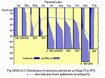
Distribution of ammonia and nitrate as N [micro g l-1] in 1979 (11).
E8 PHOSPHORUS CONCENTRATION
PO4-P: Fig. NAM-23-10 and 11.
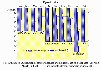
Distribution of total phosphate and soluble reactive phosphate (SRP) as P [micro g l-1] in 1979 (11).
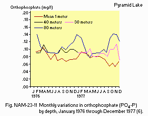
Monthly variations in orthophosphate (PO4-P) by depth, January 1976 through December 1977 (6).
Total-P [mg l-1](Q)
Station B, 1979
[m]
| Depth | Jan | Feb | Mar | Apr | May | Jun | Jul | Aug | Sep | Oct | Nov | Dec |
|---|---|---|---|---|---|---|---|---|---|---|---|---|
| 3 | .110 | - | .100 | - | .100 | .100 | .090 | .100 | .090 | .090 | .100 | - |
| 70* | .110 | - | .110 | - | .100 | .110 | .120 | .160 | .140 | .140 | .140 | - |
E9 CHLORIDE CONCENTRATION [g l-1]
[m]
| Depth | Jan | Feb | Mar | Apr | May | Jun | Jul | Aug | Sep | Oct | Nov | Dec |
|---|---|---|---|---|---|---|---|---|---|---|---|---|
| 1 | 2.0 | 1.9 | 2.0 | 2.0 | 2.0 | 2.0 | 2.0 | 2.1 | 2.0 | 2.0 | 2.1 | 2.0 |
| 40 | 2.0 | 1.9 | 2.0 | 2.0 | 2.0 | 2.0 | 2.0 | 2.0 | 2.0 | 2.0 | 2.1 | 2.0 |
| 80 | 2.0 | 1.9 | 2.0 | 2.0 | 2.0 | 2.0 | 2.0 | 2.0 | 2.0 | 2.0 | 2.0 | 2.0 |
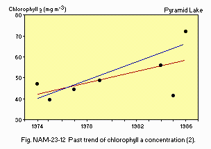
Past trend of chlorophyll a concentration (2).
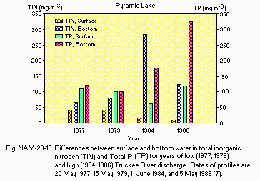
Differences between surface and bottom water in total inorganic nitrogen (TIN) and total phosphorus (TP) for years of low (1977, 1979) and high (1984, 1986) Truckee River discharge. Dates of profiles are 20 May 1977, 15 May 1979, 11 June 1984, and 5 May 1986 (7).
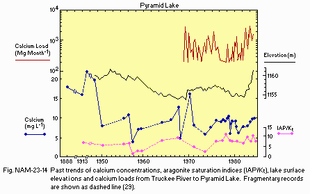
Past trends of calcium concentrations, aragonite saturation indices (IAP/Kt), lake surface elevations and calcium loads from Truckee River to Pyramid Lake. Fragmentary records are shown as dashed line (29).
F. BIOLOGICAL FEATURES
F1 FLORA (6, 17)Emerged macrophytes: None.
Floating macrophytes: None.
Submerged macrophytes: Zannichellia palustris, Ruppia maritima.
Phytoplankton
Nodularia spumigena, Cyclotella spp., Chaetoceros elmorei, Coscinodiscus sp.
F2 FAUNA (6, 17)
Zooplankton
Diaptomus sicilis, Moina hutchinsoni, Ceriodaphnia quadrangula, Diaphanosoma leuchtenbergianum, Daphnia schodleri, Cyclops vernalis.
Benthos
Oligochaeta (Limnodrilus hoffmeisteri), Hirudinea (Helobdella stagnalis), Amphipoda (Hyallela azteca), Ostracoda (Eucypris sp.), Odonata (Argia emma), Coleoptera (Hydrobius fuscipes), Chironomidae (Chironomus sp.).
Fish
Gila bicolor, Catostomus tahoensis, Salmo clarki henshawi*, Chasmistes cujus**, Archoplites interruptus.
*Salmo clarki henshawi is federally listed as threatened, 1975. **Chasmistes cujus is federally listed as endangered, 1967.
F5 FISHERY PRODUCTS (22)
Annual sport-fish catch [metric tons]
1986: 30.
Fishery products other than fish: None.
Estimated potential production of G. bicolor amounts to 100 kg ha-1 yr-1, and that of S. clarki henshawi to 20 kg ha-1 yr-1 based on primary production (PPR) and empirical PPR to G. bicolor trophic efficiency in mesocosms.
F7 NOTES ON THE REMARKABLE CHANGES OF BIOTA IN THE LAKE IN RECENT YEARS
Because of extinction in 1938, S. clarki henshawi was reintroduced in the 1950's and listed as federally threatened in 1975 (13). C. cujus population has declined dramatically and listed as federally endangered in 1967 (14, 15). Salinity increases due to reduction in lake volume, favoring salt tolerant algae (2, 16), zooplankton (17) and benthic invertebrates (18).
G. SOCIO-ECONOMIC CONDITIONS
G1 LAND USE IN THE RESERVATION AREA* (6, 19)1982
| Area [km2] | [%] | |
|---|---|---|
| Natural landscape | ||
| Woody vegetation | 137.6 | 98.9 |
| Herbaceous vegetation | 0 | |
| Agricultural land | ||
| Crop field | 4.85 | 0.3 |
| Residential area | 10.33 | 0.7 |
| Others | 0.81 | 0.1 |
| Total | 1,391.99 | 100 |
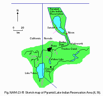
Sketch map of Pyramid Lake Indian Reservation Area (6, 19).
Types of important forest: Populus fremonyi, Juniperus utahensis.
Types of important herbaceous vegetation (6)
Artemesia tridentata, Atriplex confertifolia, Chrysothamnus nauseosus,
Sarcobatus vermiculatus.
Trends of change in land use
Same today as 5 years ago. A few more acres are in agriculture use
(primarily alfalfa, some pasture).
G2 INDUSTRIES IN THE CATCHMENT AREA AND THE LAKE (20)
1987
| Gross product | No. of | No. of | Main product | |
|---|---|---|---|---|
| per year | persons | establish- | or major | |
| (US$) | engaged | ments | industries | |
| Primary industry | ||||
| Crop | 658,125 | 43 | 43 | Alfalfa |
| production | ||||
| Animal | 319,150 | 75 | 1 | Cattle |
| husbandry | ||||
| Fisheries | 257,437 | 23,087 | 1 | Fishing |
| Others | 86,047 | 9,236 | 1 | Boating and camping |
| Secondary | 180,000 | 9 | 1 | Aggregates/ |
| industry | gravel | |||
| Tertiary | 512,430 | 5 | 1 | Bar/store |
| industry |
Number of domestic animals in the reservation area: Cattle 1,700.
G3 POPULATION IN THE RESERVATION AREA (21)
1987
| Population | Major cities | ||
|---|---|---|---|
| Population | density [km-2] | (population) | |
| Urban | ca. 220,000 | Reno/Sparks | |
| Rural | 1,370 | Wadsworth, Nixon, Sutcliffe |
H. LAKE UTILIZATION (22)
H1 LAKE UTILIZATION Source of water, sightseeing and tourism, recreation (swimming, sport-fishing) and fisheries.H2 THE LAKE AS WATER RESOURCE 1988
| Use rate [m3 day-1] | |
|---|---|
| Hatchery lake operation | 13,626 |
| (recycled back to lake) |
I. DETERIORATION OF LAKE ENVIRONMENTS AND HAZARDS
I1 ENHANCED SILTATIONExtent of damage: Serious.
Supplementary notes (23, 24)
Bank erosion on the Lower Truckee River, especially in the Nixon area, has resulted in loss of crop land, and houses having to be moved. In 1986, material from eroded banks completely filled-in the Marble Bluff Reservoir below Nixon (approximately 5 km above Pyramid Lake). The declining lake level has adversely affected the hydraulics of the Lower Truckee River, resulting in bank erosion, and formation of a massive delta at the river mouth. In addition, spawning gravels have become heavily silted, resulting in low egg survival for threatened Lohontan Cutthroat Trout and endangered Cui-ui.
I3 EUTROPHICATION Nuisance caused by eutrophication
Unusual algal bloom (Nodularia spumigena)(1, 2, 6, 7, 10, 11).
Nitrogen and phosphorus loadings to the lake
Fluvial P-load to lake increased from 1973-1891, then declined following P removal from Reno/Sparks sewage effluent. Fluvial nitrogen loads show no long-term trend other than a positive correlation with Truckee River discharge (7, 25). Fluvial nitrogen loads are expected to decrease following nitrification/denitrification at Reno/Sparks sew age beginning in 1989 (26).
I4 ACIDIFICATION Extent of damage: None. Past trends of pH in lake water
| Year | pH | Year | pH | Year | pH |
|---|---|---|---|---|---|
| 1882 | 9.0 | 1957 | 9.0 | 1971 | 9.2 |
| 1913 | 9.0 | 1958 | 8.5 | 1973 | 8.5 |
| 1951 | 9.2 | 1959 | 8.9 | 1975 | 9.3 |
| 1955 | 9.1 | 1964 | 9.4 | 1988 | 9.1 |
| 1956 | 9.1 | 1967 | 9.1 |
J. WASTEWATER TREATMENTS
J1 GENERATION OF POLLUTANTS IN THE CATCHMENT AREA- d) Measurable pollution with limited wastewater treatment.
| Washoe County, Nevada | [%] |
|---|---|
| Non-point sources | 4 |
| (Agricultural, natural and | |
| dispersed settlements) | |
| Point sources | |
| Municipal | 96 |
| Total | 100 |
K. IMPROVEMENT WORKS IN THE LAKE (Q)
K1 RESTORATION Reintroduction of Lahontan Cutthroat Trout in 1950'. Maintained only by hatchery production to present.K3 OTHERS Construction of boat launching docks, vehicle access and maintenance.
L. DEVELOPMENT PLANS (Q)
Housing projects in the Nixon, Wadsworth and Suycliff areas, ongoing since about 1979. Growth rate of Reno/Sparks estimated at 3.5% a year. Sewage lagoon planned for Wadsworth. Expansion of tertiary treatment at Reno/Sparks Joint Sewage Treatment Plan; piping of effluent to Lahontan Reservoir is also being considered.M. LEGISLATIVE AND INSTITUTIONAL MEASURES FOR UPGRADING LAKE ENVIRONMENTS (Q)
M1 NATIONAL AND LOCAL LAWS CONCERNED Names of the laws (the year of legislation)- Endangered Species Act (1973)
- Amendments to Clean Water Act (1987) Responsible authorities
- Pyramid Lake Tribal Council
- U.S. Fish and Wildlife Service
- U.S. Environmental Protection Agency
- Nevada Department of Environmental Protection Main items of control
- Indian Tribes via Tribal Council, granted same authority as States*.
- State and Federal H2O quality standards and effluent discharge permits.
- Enforcement of Endangered Species Act against "taking" of listed species.
- Tribal litigation to enforce 2 and 3. * Regarding establishment of water quality standards and safe drinking water.
- U.S. Fish and Wildlife Service: National Fishery Research Centre (Seattle, WA), Great Basin Complex Office (Reno, NV) Cooperative Fish and Wildlife Research Unit (Columbia, MO).
- University of California, Davis
- U.S. Geological Survey, Denver, Colorado
- Desert Research Institute, Reno, Nevada
N. SOURCES OF DATA
- Questionnaire filled by Prof. D. L. Galat, Cooperative Fish & Wildlife Research Unit, University of Missouri, Columbia, and Dr. L. Carlson, Resource Management Department, Pyramid Lake Fisheries, Sutcliffe, Nevada, based on data obtained from the following sources (1-23).
- Horne, A. J. & Galat, D. L. (1985) Limnol. Oceanogr., 30: 1229-1239.
- Galat, D. L., Verdin, J. P. & Sims, L. L. (1989) Hydrobiologia, (in press).
- Wheeler, S. S. (1974) The Desert Lake: the Story of Nevada's Pyramid Lake. Caxton Printers, Ltd., Caldwell, Idaho.
- Knack, M. C. & Stewart, 0. C. (1984) As Long as the River Shall Run: An Ethnohistory of Pyramid Lake Indian Reservation. Univ. of California Press.
- Trelease, T. J. (1953) The death of a lake. Field and Stream, February.
- Galat, D. L., Lider, E. L., Vigg, S. & Robertson, S. R. (1981) Hydrobiologia, 82: 281-317.
- Galat, D. L. & Verdin, J. P. (1988) Can. J. Fish. Aquat. Sci., 45: 1959- 1967.
- Sigler, W. F. & Kennedy, J. L. (1978) Pyramid Lake Ecological Study. W. F. Sigler & Associates, Logan, Utah.
- Galat, D. L. & Verdin, J. P. (1989) J. Plankton Res., 11: (in press).
- Galat, D. L. (1986) Int. Revue ges. Hydrobiol., 71: 621-654.
- Hamilton-Galat, K. & Galat, D. L. (1983) Hydrobiologia, 105: 27-43.
- Vigg, S. (1981) Great Basin Nat., 41: 395-408.
- Sigler, W. F., Helm, W. T., Kucera, P. A., Vigg, S. & Workman, G. W. (1983) Great Basin Nat., 43: 1-29.
- Scoppettone, G. G., Coleman, M. & Wedemeyer, G. A. (1986) Life History and Status of the Endangered Cui-ui of Pyramid Lake, Nevada. Fish & Wildlife Res. 1, U.S. Fish & Wildlife Service, Washington, D. C.
- Sigler, W. F., Vigg, S. & Bres, M. (1985) Great Basin Nat., 45: 571-603.
- Galat, D. L. & McConnell, (1981) Effect of Increasing Total Dissolved Solids on the Dynamics of Pyramid Lake Microcosm Communities. Cooperative Fishery Research Unit, Colorado State University, Ft. Collins.
- Galat, D. L. & Robinson, R. (1983) Hydrobiologia, 105: 115-131.
- Galat, D. L., Coleman, M. & Robinson, R. (1988) Hydrobiologia, 158: 133- 144.
- Pyramid Lake Paiute Tribe (1982) Management Agency Evaluation for Continued 208 Water Quality Monitoring. Pyramid Lake Indian Tribal Council, Nixon, Nevada.
- Pyramid Lake Paiute Tribe. Personal communication with Tribal Planner, Tribal Treasurer, Cattlemen's Assoc.
- Pyramid Lake Paiute Tribe (1987) Community Block Grant.
- Pyramid Lake Fisheries. Personal communication with Resource Management Department and Fisheries Director.
- U.S. Fish & Wildlife Service (1983) Restoration of a Reproductive Population of Lahontan Cutthroat Trout (Salmo clarki henshawi) to the Truckee River/Pyramid Lake System. U.S. Fish & Wildlife Service, Great Basin Complex, Reno, Nevada.
- Hoffman, R. J. & Scoppettone, G. G. (1982) Survival of Lahontan Cutthroat Trout Eggs Relative to the Quality of the Truckee River, Nevada. Open-File Report 82-xxx. U.S. Geological Survey, Carson City, Nevada.
- Galat, D. L. (1989) Long-term Trends in Fluvial Nutrient Loading to Pyramid Lake, Nevada. Cooperative Fish & Wildlife Research Unit, University of Missouri, Columbia.
- U.S. Environmental Protection Agency (1980) Draft Environmental Impact Statement: Reno/Sparks Joint Water Pollution Control Plant Master Project. EPA-9-CA-C-32-0114. U.S. EPA, Region 9, San Francisco, California.
- Washoe Council of Governments (1978) Water Quality Management Plan - Washoe County, Nevada. Washoe Council of Governments, Reno, Nevada.
- Galat, D. L. (1982) Primary Production as a Predictor of Potential Fish Production: Application to Pyramid Lake, Nevada. Doctoral Dissertation, Colorado State University, Ft. Collins.
- Galat, D. L. & Jacobsen, R. L. (1985) Arch. Hydrobiol., 105: 137-159.
