TWIN LAKES
An aerial view of the whole lake from the northeast
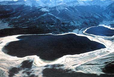
Photo: J. F. LaBounty
A. LOCATION
Colorado, USA.
39:5N, 106:0W; 2,804 m above sea level.
B. DESCRIPTION
Twin Lakes are located on the eastern slope of the
Rocky Mountains in western North America. They lie at an altitude of 2,804
m above mean sea level, in the Montane Life Zone of Colorado. Twin Lakes
are a pair of connected lakes which were originally formed by the morainal
damming of Lake Creek by a Pleistocene glacier. This creek, a small tributary
of the Arkansas River, was the main source of inflow to the lakes in their
natural state.
The Lake Creek watershed is relatively small,
with an area of only 238 km2. While the lakes themselves lie in deposits
of glacial till, Lake Creek drains mainly the crystalline rocks and eroded
ore bodies of the eastern slope of the Sawatch Range, along the Continental
Divide. Consequently, the deeper sediments of both lakes, which are composed
of a fine glacial rock flour, have accumulated large quantities of heavy
metals, including iron, manganese, copper, zinc, lead, and cadmium.
The climate here is cool and semi-arid. Twin Lakes
are dimictic, with an ice cover usually lasting from early December to
early May in an average year. Maximum ice thickness ranges from about 60
cm, in an average year, to a meter or more during severe winters. Summer
thermal stratification normally reaches its maximum in August, with surface
water temperatures in the range of 15¡¦to 18¡¦, and bottom temperatures
of about 9¡¦.
Upper Twin Lakes had a normal surface elevation
nearly 2 m higher than the lower lake, and the natural fluctuation of surface
elevation in each lake probably did not exceed 0.6 m annually. The normal
surface area of the upper lake was about 220 ha, with a corresponding maximum
depth of about 25 m. Lower Twin Lakes was larger in surface area, about
610 ha, but more shallow, with a maximum depth of about 23 m. Both lakes
were probably oligotrophic, but they harbored diverse zooplankton and fish
communities. One species of native trout was described as being endemic
to Twin Lakes.
Permanent settlement began in this area in the
late 1870's, and almost immediately the settlers began changing the ecology
of Twin Lakes through the introduction of exotic species, and by modifications
of the hydraulic regime, which were aimed at converting the lakes into
water-supply reservoirs for irrigation and mining.
Since the turn of the century, a series of hydraulic
engineering works had converted Twin Lakes into a pair of connected reservoirs.
First, the natural outlet of the lower lake was dammed, and a deeper, gated
outlet was constructed about 1 km to the north. This arrangement allowed
a potential vertical fluctuation of 7.8 m in the water surface elevation
of the lower lake. Next, the stream connecting the lake was dredged into
a channel that allowed the two bodies of water to fluctuate essentially
as one. Finally, a tunnel was constructed under the Continental Divide
to divert water from the western slope into Lake Creek. This transmountain
diversion increased the total annual discharge of Lake Creek by an average
of 42%. It is important to note here that this additional inflow was all
added during the irrigation season, which extends from approximately June
through September. Thus, the extra flow had the effect of increasing and
prolonging the natural runoff peak in Lake Creek.
The net result of these hydraulic changes was
increased erosion in the inflow area of the upper lake. What had originally
been a marshy meadow was now an eroded floodplain, and the resulting woody
debris was deposited in the bottom of Upper Twin Lakes. During severe winters,
with prolonged ice and snow cover, this allochthonous organic deposit exerted
a biochemical oxygen demand that resulted in extreme hypolimnetic anoxia,
with toxic metal releases from the sediments. Primary production in the
upper lake was also limited by intense flushing and turbidity during the
spring runoff period. In fact, the upper lake functioned as a settling
basin and buffer for the lower lake (1).
C. PHYSICAL DIMENSIONS (3, 6)
|
| Basin |
Upper Lake |
Lower Lake* |
|
| Surface area [km2] |
3.8 |
7.4 |
| Volume [km3] |
55 |
0.118 |
| Maximum depth [m] |
30.2 |
29.3 |
| Mean depth [m] |
14.5 |
16.0 |
| Normal range of annual water |
| level fluctuation [m] |
2.5-4.5 |
| Length of shoreline [km] |
10.7 |
13.7 |
| Residence time [yr] |
0.47 |
| Catchment area [km2] |
238 |
* This is after raising of lake levels behind new dam in October 1983.
D. PHYSIOGRAPHIC FEATURES
D1 GEOGRAPHICAL
Sketch map: Fig. NAM-21-01.
Names of main islands: None.
Number of outflowing rivers and channels (name): 1 (Lake Creek).
D2 CLIMATIC
Climatic data at Station 3*, 1982 (1, 2)
|
| Jan |
Feb |
Mar |
Apr |
May |
Jun |
Jul |
Aug |
Sep |
Oct |
Nov |
Dec |
Ann. |
|
| -7.8 |
- |
- |
- |
5.2 |
9.7 |
13.4 |
13.3 |
9.0 |
2.4 |
-3.1 |
-5.9 |
2.3 |
Precipitation [mm]
|
| Jan |
Feb |
Mar |
Apr |
May |
Jun |
Jul |
Aug |
Sep |
Oct |
Nov |
Dec |
Ann. |
|
| 34 |
- |
- |
- |
- |
- |
69 |
- |
- |
- |
- |
- |
469 |
* Lower Lake.
Solar radiation [MJ m-2 day-1](1, 2)
|
| Jan |
Feb |
Mar |
Apr |
May |
Jun |
Jul |
Aug |
Sep |
Oct |
Nov |
Dec |
Ann. |
|
| 10.0 |
- |
- |
- |
28.2 |
27.3 |
26.6 |
26.8 |
21.4 |
21.5 |
- |
- |
11.8 |
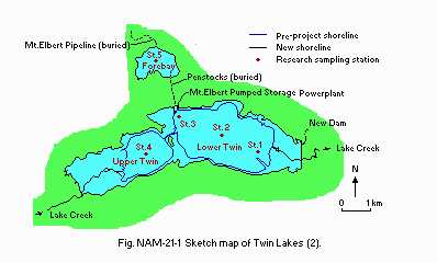
Fig. NAM-21-01
Sketch map (2).
Water temperature [deg C](2)
Station 4*, 1982
[m]
|
| Jan |
Feb |
Mar |
Apr |
May |
Jun |
Jul |
Aug |
Sep |
Oct |
Nov |
Dec |
Ann. |
|
| 1 |
- |
- |
- |
- |
7.2 |
8.0 |
11.4 |
14.7 |
12.5 |
7.2 |
4.7 |
- |
| 13 |
- |
- |
- |
- |
6.9 |
6.8 |
7.5 |
8.4 |
9.0 |
7.8 |
5.3 |
- |
* Upper Lake.
Station 2*, 1982
[m]
|
| Depth |
Jan |
Feb |
Mar |
Apr |
May |
Jun |
Jul |
Aug |
Sep |
Oct |
Nov |
Dec |
|
| 1 |
- |
- |
- |
- |
7.4 |
9.4 |
13.9 |
15.4 |
N.A. |
8.8 |
5.6 |
- |
| 13 |
- |
- |
- |
- |
6.5 |
8.9 |
10.1 |
11.0 |
11.7 |
8.9 |
5.2 |
- |
* Lower Lake.
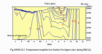
Fig. NAM-21-02
Temperature isopleths for Station 4 in Upper Lake during 1982 (2).
Freezing period: Early December-early May.
E. LAKE WATER QUALITY
E1 TRANSPARENCY [m](3)
Station 4*1, 1972-1975
|
| Depth |
Jan |
Feb |
Mar |
Apr |
May |
Jun |
Jul |
Aug |
Sep |
Oct |
Nov |
Dec |
|
| S*2 |
- |
- |
- |
- |
- |
- |
1.9 |
4.1 |
6.5 |
- |
- |
- |
| E*3 |
- |
- |
- |
- |
- |
4.3 |
5.1 |
7.3 |
9.7 |
11.2 |
11.2 |
- |
*1 Upper Lake. *2 Secchi depth. *3 Euphotic depth.
Station 2*, 1972-1975
|
| Depth |
Jan |
Feb |
Mar |
Apr |
May |
Jun |
Jul |
Aug |
Sep |
Oct |
Nov |
Dec |
|
| S |
- |
- |
- |
- |
- |
3.5 |
4.6 |
4.2 |
5.0 |
3.5 |
4.0 |
- |
| E |
- |
- |
- |
- |
9.1 |
8.2 |
9.8 |
9.9 |
11.0 |
9.8 |
- |
- |
* Lower Lake.
E2 pH (2)
Station 4*, 1982
[m]
|
| Depth |
Jan |
Feb |
Mar |
Apr |
May |
Jun |
Jul |
Aug |
Sep |
Oct |
Nov |
Dec |
|
| 1 |
- |
- |
- |
- |
6.83 |
6.74 |
6.64 |
6.98 |
6.92 |
6.81 |
7.12 |
- |
| 13 |
- |
- |
- |
- |
6.84 |
6.48 |
6.37 |
6.37 |
6.34 |
6.74 |
6.9 |
- |
* Upper Lake.
Station 2*, 1982
[m]
|
| Depth |
Jan |
Feb |
Mar |
Apr |
May |
Jun |
Jul |
Aug |
Sep |
Oct |
Nov |
Dec |
|
| 1 |
- |
- |
- |
- |
6.7 |
7.45 |
7.60 |
7.87 |
7.42 |
7.12 |
7.0 |
- |
| 13 |
- |
- |
- |
- |
6.9 |
6.97 |
6.68 |
6.65 |
6.55 |
7.16 |
7.35 |
- |
* Lower Lake.
E4 DO [mg l-1]: Fig. NAM-21-03 and 04.
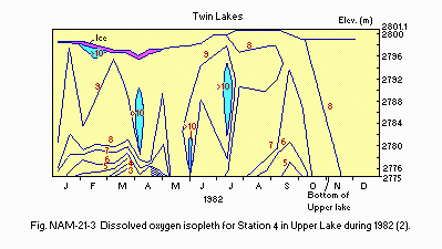
Fig. NAM-21-03
Dissolved oxygen isopleth for Station 4 in Upper Lake during 1982 (2).
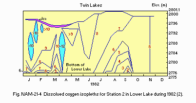
Fig. NAM-21-04
Dissolved oxygen isopleths for Station 2 in Lower Lake during 1982
(2).
E6 CHLOROPHYLL CONCENTRATION [micro g l-1](2)
Upper Lake, 1982
[m]
|
| Depth |
Jan |
Feb |
Mar |
Apr |
May |
Jun |
Jul |
Aug |
Sep |
Oct |
Nov |
Dec |
|
| 0.1 |
- |
- |
- |
- |
- |
- |
0.49 |
- |
- |
- |
5.26 |
- |
| 1.0 |
- |
- |
- |
- |
- |
- |
- |
- |
- |
- |
- |
- |
| 3.0 |
2.79 |
- |
2.10 |
- |
- |
0.96 |
- |
- |
- |
3.43 |
- |
- |
| 5.0 |
1.49 |
2.00 |
- |
2.35 |
- |
1.24 |
- |
- |
2.45 |
2.67 |
4.45 |
- |
| 9.0 |
- |
- |
- |
2.19 |
1.92 |
- |
0.97 |
1.43 |
1.70 |
- |
- |
- |
Lower Lake, 1982
[m]
|
| Depth |
Jan |
Feb |
Mar |
Apr |
May |
Jun |
Jul |
Aug |
Sep |
Oct |
Nov |
Dec |
|
| 0.1 |
3.55 |
- |
- |
- |
- |
- |
- |
- |
- |
4.65 |
6.22 |
- |
| 1.0 |
- |
- |
2.05 |
- |
- |
- |
- |
- |
- |
- |
- |
- |
| 3.0 |
2.41 |
2.37 |
3.04 |
- |
- |
2.93 |
- |
- |
- |
- |
- |
- |
| 5.0 |
- |
2.33 |
- |
- |
- |
3.07 |
- |
3.03 |
- |
5.61 |
6.87 |
- |
| 9.0 |
- |
- |
- |
2.75 |
3.73 |
- |
2.76 |
3.46 |
3.55 |
- |
- |
- |
| 15.0 |
- |
- |
- |
2.77 |
3.24 |
2.66 |
- |
- |
- |
- |
6.71 |
- |
Chlorophyll a [mg m-2]
Upper Lake, 1982
[m]
|
| Depth |
Jan |
Feb |
Mar |
Apr |
May |
Jun |
Jul |
Aug |
Sep |
Oct |
Nov |
Dec |
|
|
31.95 |
31.83 |
31.11 |
35.59 |
34.72 |
15.77 |
10.08 |
24.83 |
32.30 |
45.37 |
70.73 |
- |
Lower Lake, 1982
[m]
|
| Depth |
Jan |
Feb |
Mar |
Apr |
May |
Jun |
Jul |
Aug |
Sep |
Oct |
Nov |
Dec |
|
|
44.16 |
36.69 |
37.69 |
42.65 |
55.78 |
44.74 |
42.34 |
53.20 |
55.06 |
76.79 |
99.74 |
- |
E7 NITROGEN CONCENTRATION (2)
NO3-N [mg l-1]
Upper Lake, 1982
[m]
|
| Depth |
Jan |
Feb |
Mar |
Apr |
May |
Jun |
Jul |
Aug |
Sep |
Oct |
Nov |
Dec |
|
| S*1 |
.038 |
- |
- |
- |
.060 |
- |
.032 |
- |
- |
.048 |
- |
- |
| M*2 |
.038 |
- |
- |
- |
.090 |
- |
.038 |
- |
- |
.048 |
- |
- |
| B*3 |
.042 |
- |
- |
- |
.010 |
- |
.056 |
- |
- |
.048 |
- |
- |
*1 Surface. *2 Middle. *3 Bottom.
Lower Lake, 1982
[m]
|
| Depth |
Jan |
Feb |
Mar |
Apr |
May |
Jun |
Jul |
Aug |
Sep |
Oct |
Nov |
Dec |
|
| S |
<.001 |
- |
- |
- |
.020 |
- |
.010 |
- |
- |
.010 |
- |
- |
| M |
<.001 |
- |
- |
- |
.021 |
- |
.015 |
- |
- |
.010 |
- |
- |
| B |
.004 |
- |
- |
- |
.068 |
- |
.041 |
- |
- |
.010 |
- |
- |
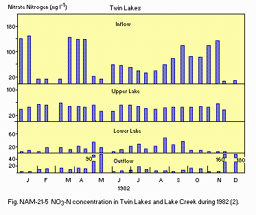
Fig. NAM-21-05 NO3-N concentration in Twin Lakes and Lake Creek during
1982 (2).
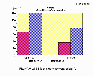
Fig. NAM-21-06
Mean nitrate concentration (1).
E8 PHOSPHORUS CONCENTRATION (2)
Total-P [mg l-1]
Upper Lake, 1982
[m]
|
| Depth |
Jan |
Feb |
Mar |
Apr |
May |
Jun |
Jul |
Aug |
Sep |
Oct |
Nov |
Dec |
|
| S*1 |
.003 |
- |
- |
- |
<.001 |
- |
<.001 |
- |
- |
<.001 |
- |
- |
| M*2 |
.004 |
- |
- |
- |
<.001 |
- |
<.001 |
- |
- |
<.001 |
- |
- |
| B*3 |
.002 |
- |
- |
- |
<.001 |
- |
<.001 |
- |
- |
<.001 |
- |
- |
*1 Surface. *2 Middle. *3 Bottom.
Lower Lake, 1982
[m]
|
| Depth |
Jan |
Feb |
Mar |
Apr |
May |
Jun |
Jul |
Aug |
Sep |
Oct |
Nov |
Dec |
|
| S |
.004 |
- |
- |
- |
.005 |
- |
.003 |
- |
- |
<.001 |
- |
- |
| M |
.021 |
- |
- |
- |
<.001 |
- |
.002 |
- |
- |
<.001 |
- |
- |
| B |
.006 |
- |
- |
- |
<.001 |
- |
.001 |
- |
- |
<.001 |
- |
- |
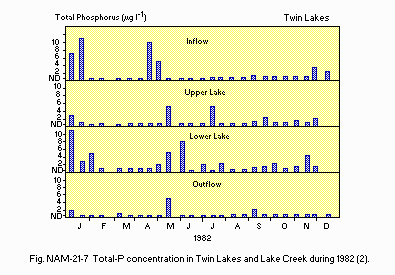
Fig. NAM-21-07
Total-P concentration in Twin Lakes and Lake Creek during 1982 (2).
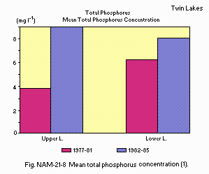
Fig. NAM-21-08
Mean total phosphorus concentration (1).
E10 PAST TRENDS: Fig. NAM-21-09 and 10.
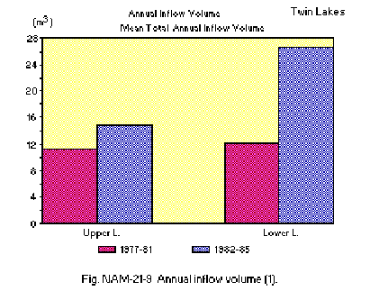
Fig. NAM-21-09
Annual inflow volume (1).
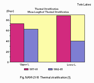
Fig. NAM-21-10
Thermal stratification (l).
F. BIOLOGICAL FEATURES
F1 FLORA
Emerged macrophytes: None.
Floating macrophytes: None.
Submerged macrophytes (4, 7)
Potamogeton amplifolius, P. praelongus, Chara globularis, Chara sp.,
Nitella opaca, Elodea sp.
Phytoplankton (5)
1976
Chysophyta (Dinobryon cylindricum, Mallomonas elongata, M. pseudocoronata),
Chlorophyta (Dictyosphaerium pulchellum, Sphaerocystis schroeteri, Staurastrum
longiradiatum), Bacillariophyta (Asterionella formosa, Synedra amphicephala,
S. delicatissima, S. radians, S. ulna var. danica, Tabellaria flocculosa),
Cyanophyta (Oscillatoria amphibia, O. tenuis).
F2 FAUNA
Zooplankton (5)
1974-1982
Cladocera (Daphnia pulex*, D. rosea*, Bosmina longirostris*), Copepoda
(Diaptomus judayi*, D. connexus*, Cyclops bicuspidatus thomasi*), Rotifera
(Kellicottia longispina*, Keratella cochlearis*, Polyarthra sp., Brachionus
sp.), Mysidacea (Mysis relicta).
* Organisms examined for species identification.
Benthos
Chironomidae, Oligochaeta. Pisidium casertanum, P. pauperculum. Mysis
rest on the bottom during daylight hours and are sometimes captured in
benthic dredges. but they move into the water column to feed at night.
They are more zooplankton than benthos.
Fish (4)
Salvelinus namaycush*, Salmo gairdneri*, S. trutta, S. clarki, Catostomus
commersoni, C. catostomus, Oncorhynchus nerka.
* Important for sport-fishing.
F3 PRIMARY PRODUCTION RATE [mg C m-2 hr-1](2)
Determined by 14C technique
Upper Lake, 1982
Net production
|
|
|
|
|
|
|
|
|
|
|
|
|
Ann. |
| Jan |
Feb |
Mar |
Apr |
May |
Jun |
Jul |
Aug |
Sep |
Oct |
Nov |
Dec |
total |
|
| 2.9 |
1.8 |
2.7 |
2.1 |
5.4 |
2.4 |
0.6 |
3.6 |
4.0 |
2.8 |
2.0 |
- |
12,825 |
Lower Lake, 1982
Net production
|
|
|
|
|
|
|
|
|
|
|
|
|
Ann. |
| Jan |
Feb |
Mar |
Apr |
May |
Jun |
Jul |
Aug |
Sep |
Oct |
Nov |
Dec |
total |
|
| 2.3 |
2.3 |
3.8 |
0.5 |
10.3 |
8.2 |
9.7 |
5.5 |
9.7 |
9.0 |
6.1 |
- |
24,780 |
F4 BIOMASS (2)
Benthos
Upper Lake, 1982
|
|
[No. m-2]* |
[g (dry wt.) m-2]* |
|
| Chironomids |
270 |
0.50 |
| Oligochaetes |
1,585 |
0.33 |
| Pisidium spp. |
54 |
0.03 |
| Mysis relicta |
6 |
0.01 |
Lower Lake, 1982
|
|
[No. m-2]* |
[g (dry wt.) m-2]* |
|
| Chironomids |
762 |
0.85 |
| Oligochaetes |
536 |
0.11 |
| Pisidium spp. |
651 |
0.64 |
| Mysis relicta |
37 |
0.05 |
* 3 samples.
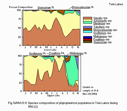 Fig. NAM-21-11
Special composition of phytoplankton population in Twin Lakes during
1982 (2).
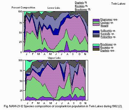
Fig. NAM-21-12
Species composition of zooplankton population in Twin Lakes during
1982 (2).
F6 PAST TRENDS: Fig. NAM-21-13, 14, 15, 16, 17 and 18 (2).
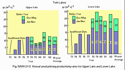
Fig. NAM-21-13
Annual areal primary productivity rates for Upper Lake and Lower Lake.
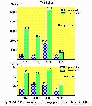
Fig. NAM-21-14
Comparison of average plankton densities, 1979-1982.
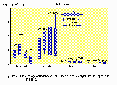
Fig. NAM-21-15
Average abundance of four types of benthic organisms in Upper Lake,
1979-1982.
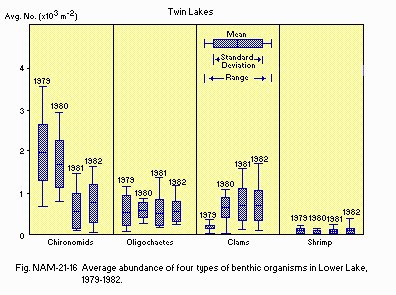
Fig. NAM-21-16
Average abundance of four types of benthic organisms in Lower Lake,
1979-1982.
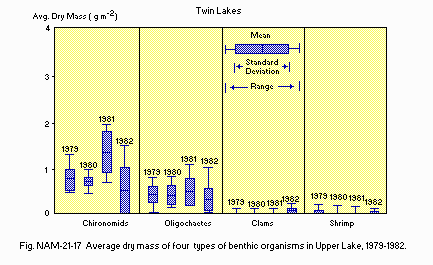
Fig. NAM-21-17
Average dry mass of four types of benthic organisms in Upper Lake,
1979-1982.
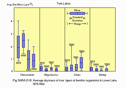
Fig. NAM-21-18
Average dry mass of four types of benthic organisms in Lower Lake,
1979-1982.
G. SOCIO-ECONOMIC CONDITIONS (8)
G1 LAND USE IN THE CATCHMENT AREA
1989
|
|
Area [km2] |
[%] |
|
| Natural landscape |
| Woody vegetation |
118 |
| Herbaceous vegetation |
19 |
| Swamp |
5 |
| Alpine tundra-rock |
94 |
| Residential area |
<2 |
<1 |
| Total |
238 |
100 |
Types of important forest: Fir, pine, aspen and sagebrush.
Types of important herbaceous vegetation: Bunch grasses and sedges.
Types of the other important vegetation
Alpine vegetation (mat and cushion plants, dwarf willows).
Main kinds of crops: None.
Levels of fertilizer application on crop fields: None.
Trends of change in land use
Area immediately around lakes taken over as forest service managed
camping and picnic areas. Private cabins and resort facilities removed.
Some new cabins built in areas further away from lakes on private land.
G2 INDUSTRIES IN THE CATCHMENT AREA AND THE LAKE
1989: None.
G3 POPULATION IN THE CATCHMENT AREA
1989
|
|
|
Population |
Major cities |
|
Population |
density [km-2] |
(population) |
|
| Urban |
None |
| Rural |
ca. 100-200* |
|
Twin Lakes |
| Total |
* Depending on season - more in summer.
H. LAKE UTILIZATION (8)
H1 LAKE UTILIZATION
Source of water, sight-seeing and tourism (in summer 1988, 16,201 visited
Mt. Elbert powerplant visitor's centre - summer only 3 months) and recreation
(sport-fishing in summer and ice-fishing in winter).
H2 THE LAKE AS WATER RESOURCE
|
|
Use rate [m3 day-1] |
|
| Domestic & |
| Industrial*1 |
100,482 |
| Irrigation |
113,557/ha irrigated annually. |
| Power plant*2 |
200 MW |
*1 These 2 are lumped by the Bureau as "M & I" (municipal and industrial)
water.
*2 Pumped-storage hydroelectric plant.
I. DETERIORATION OF LAKE ENVIRONMENTS AND HAZARDS (8)
I1 ENHANCED SILTATION Extent of damage: None.
I2 TOXIC CONTAMINATION Present status: None.
I3 EUTROPHICATION
Nitrogen and phosphorus loadings to the lake [kg day-1]
1984
|
| Sources |
Natural |
Total |
|
| DIN |
52.7 |
52.7 |
| T-P |
6.8 |
6.8 |
Supplementary notes: Lake is oligotrophic.
I4 ACIDIFICATION
Extent of damage: None.
I5 OTHER HAZARDS
Potential for release of heavy metals from sediments during extreme
winter anoxia - Fe, Mn, Cu, Zn, especially. Sediment accumulations are
result of glacial action and erosion on natural ore bodies in the watershed.
J. WASTEWATER TREATMENTS (8)
J1 GENERATION OR POLLUTANTS IN THE CATCHMENT AREA
a) Pristine lake environments.
K. IMPROVEMENT WORKS IN THE LAKE (8)
None.
L. DEVELOPMENT PLANS (8)
U.S. Forest Service manages area for camping, picnicking, hiking - outdoor
recreation. Colorado Division of Wildlife manages sport.fishing of the
lakes - mostly stocked rainbow trout (Salmo gairdneri) and self-sustaining
lake trout (Salvelinus namaycush).
N. SOURCES OF DATA
-
Questionnaire prepared by the editors with the support of Dr. J. F. LaBounty,
Environmental Sciences Section, Bureau of Reclamation, United State Department
of the Interior, Denver, Colorado, based on the following sources.
-
Sartoris, J. J. (1988) Twin Lakes, Colorado, USA: Ecological studies of
the effects of pumped-storage hydroelectric development on a pair of Montane
Lakes. Report to the Third International Conference on the Conservation
and Management of Lakes "Balaton '88", Keszthely, September 1988.
-
LaBounty, J. F., Sartoris, J. J. & Lieberman, D. M. (1984) Effects
of Operating Mt. Elbert Pumped-Storage Powerplant on Twin Lakes, Colorado:
1982 Report of Findings. U.S. Bureau of Reclamation, Denver, Colorado.
Report No. REC-ERC-84-23.
-
Sartoris, J. J., LaBounty, J. F. & Newkirk, H. D. (1977) Historical,
Physical and Chemical Limnology of Twin Lakes, Colorado. U.S. Bureau of
Reclamation, Denver, Colorado. Report No. REC-ERC-77-13.
-
Gregg, R. E. (1976) Ecology of Mysis relicta in Twin Lakes, Colorado. U.S.
Bureau of Reclamation, Denver, Colorado. Report No. REC-ERC-76-14.
-
Lieberman, D. M. (1983) Common Plankton of Twin Lakes, Colorado. U.S. Bureau
of Reclamation, Denver, Colorado. Report No. REC-ERC-82-21.
-
LaBounty, J. F., Campbell, S. G. & Sartoris, J. J. (1985) Primary Productivity
(14C) at Twin Lakes, Colorado: 1973-1981 Study Results. U.S. Bureau of
Reclamation, Denver, Colorado. Report No. REC-ERC-85-8.
-
LaBounty, J. F., Crysdale, R. A. & Eller, D. W (1976) Dive Studies
at Twin Lakes, Colorado 1974-1975. U.S. Bureau of Reclamation, Denver,
Colorado. Report No. REC-ERC-76-15.
-
Sartoris, J. J. Personal communication.

